Tandora County

Last updated

Map all coordinates using: OpenStreetMap  
Download coordinates as: KML  ·  GPX
Tandora
New South Wales
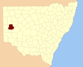
Tandora NSW.PNG
Location in New South Wales
Lands administrative divisions around Tandora:
Mootwingee Mootwingee Young
Yancowinna Tandora Livingstone
Menindee Menindee Livingstone

Tandora County is one of the 141 Cadastral divisions of New South Wales. It is located to the north west of the Darling River, to the area to the north (but not including) Menindee.

Darling River river in Australia

The Darling River is the third longest river in Australia, measuring 1,472 kilometres (915 mi) from its source in northern New South Wales to its confluence with the Murray River at Wentworth, New South Wales. Including its longest contiguous tributaries it is 2,844 km (1,767 mi) long, making it the longest river system in Australia.

The name Tandora is of unknown origin. [1] [ failed verification ]

Parishes within this county

A full list of parishes found within this county; their current LGA and mapping coordinates to the approximate centre of each location is as follows:

Local government in Australia

Local government in Australia is the third tier of government in Australia administered by the states and territories, which in turn are beneath the federal tier. Local government is not mentioned in the Constitution of Australia and two referenda in the 1970s and 1980s to alter the Constitution relating to local government were unsuccessful. Every state government recognises local government in their respective constitutions. Unlike Canada or the United States, there is only one level of local government in each state, with no distinction such as cities and counties.

ParishLGACoordinates
Bellar Unincorporated 32°08′34″S142°16′15″E / 32.14278°S 142.27083°E / -32.14278; 142.27083 (Bellar)
Burke Unincorporated 31°56′18″S142°24′03″E / 31.93833°S 142.40083°E / -31.93833; 142.40083 (Burke)
Burnayto Unincorporated 31°44′00″S142°13′48″E / 31.73333°S 142.23000°E / -31.73333; 142.23000 (Burnayto)
Eckerboon Unincorporated 31°34′55″S142°24′09″E / 31.58194°S 142.40250°E / -31.58194; 142.40250 (Eckerboon)
Hartung Unincorporated 32°17′21″S142°05′46″E / 32.28917°S 142.09611°E / -32.28917; 142.09611 (Hartung)
Herbert Unincorporated 32°00′56″S142°24′28″E / 32.01556°S 142.40778°E / -32.01556; 142.40778 (Herbert)
Hume Central Darling Shire 32°18′43″S142°22′37″E / 32.31194°S 142.37694°E / -32.31194; 142.37694 (Hume)
Kars Unincorporated 32°15′05″S142°13′34″E / 32.25139°S 142.22611°E / -32.25139; 142.22611 (Kars)
Maiden Central Darling Shire 32°08′50″S142°26′36″E / 32.14722°S 142.44333°E / -32.14722; 142.44333 (Maiden)
Malakoff Unincorporated 31°52′42″S142°35′02″E / 31.87833°S 142.58389°E / -31.87833; 142.58389 (Malakoff)
Malta Unincorporated 31°56′28″S142°03′24″E / 31.94111°S 142.05667°E / -31.94111; 142.05667 (Malta)
Mulga Gaari Central Darling Shire 31°57′37″S142°41′32″E / 31.96028°S 142.69222°E / -31.96028; 142.69222 (Mulga Gaari)
Mulga Unincorporated 32°03′22″S142°16′15″E / 32.05611°S 142.27083°E / -32.05611; 142.27083 (Mulga)
Mutlow Unincorporated 31°34′59″S142°33′08″E / 31.58306°S 142.55222°E / -31.58306; 142.55222 (Mutlow)
Nadbuck Unincorporated 31°34′53″S142°13′53″E / 31.58139°S 142.23139°E / -31.58139; 142.23139 (Nadbuck)
Nelia Gaari Central Darling Shire
Pamamaroo Central Darling Shire 32°05′29″S142°35′06″E / 32.09139°S 142.58500°E / -32.09139; 142.58500 (Pamamaroo)
PattersonUnincorporated 31°56′36″S142°13′40″E / 31.94333°S 142.22778°E / -31.94333; 142.22778 (Patterson)
Quondong Unincorporated 32°16′02″S141°58′40″E / 32.26722°S 141.97778°E / -32.26722; 141.97778 (Quondong)
Silistria Unincorporated 32°08′46″S142°05′15″E / 32.14611°S 142.08750°E / -32.14611; 142.08750 (Silistria)
Sturt Unincorporated 31°43′56″S142°24′07″E / 31.73222°S 142.40194°E / -31.73222; 142.40194 (Sturt)
Tandore Central Darling Shire 32°15′43″S142°36′27″E / 32.26194°S 142.60750°E / -32.26194; 142.60750 (Tandore)
Titabaira Central Darling Shire 32°15′01″S142°28′48″E / 32.25028°S 142.48000°E / -32.25028; 142.48000 (Titabaira)
Topar Unincorporated 31°44′57″S142°03′07″E / 31.74917°S 142.05194°E / -31.74917; 142.05194 (Topar)
Weinteriga Central Darling Shire 32°10′01″S142°39′54″E / 32.16694°S 142.66500°E / -32.16694; 142.66500 (Weinteriga)
Wills Unincorporated 31°36′18″S142°03′32″E / 31.60500°S 142.05889°E / -31.60500; 142.05889 (Wills)
Worungil Unincorporated 31°43′42″S142°32′56″E / 31.72833°S 142.54889°E / -31.72833; 142.54889 (Worungil)

Related Research Articles

Binda Town in New South Wales, Australia

Binda is a village in the Southern Tablelands region of New South Wales, Australia in Upper Lachlan Shire. At the 2016 census, Binda had a population of 280 people.

South Creek (New South Wales) river in New South Wales, Australia

The South Creek or Wianamatta, a creek that is part of the Hawkesbury-Nepean catchment, is located on the Cumberland Plain, also referred to as Greater Western Sydney, New South Wales, Australia.

Darbalara, New South Wales Town in New South Wales, Australia

Darbalara is a rural community on the east bank of the junction of the Murrumbidgee River and Tumut River in the Riverina. It is situated by road, about 25 kilometres north east of Gundagai and 25 kilometres south of Coolac.

Gloucester County, New South Wales Cadastral in New South Wales, Australia

Gloucester County was one of the original Nineteen Counties in New South Wales, and is now one of the 141 cadastral divisions of New South Wales. It includes the area around Port Stephens. It is bounded on the north and west by the Manning River, and on the south-west by the Williams River.

Northumberland County, New South Wales Cadastral in New South Wales, Australia

Northumberland County was one of the original Nineteen Counties in New South Wales and is now one of the 141 Cadastral divisions of New South Wales. It included the area to the north of Broken Bay, including Lake Macquarie and Newcastle. It was bounded by the part of the Hawkesbury River to the south, the Macdonald River to the south-west, and the Hunter River to the north.

St Vincent County Cadastral in Australian Capital Territory

St Vincent County was one of the original Nineteen Counties in New South Wales and is now one of the 141 Cadastral divisions of New South Wales. It included the south coast area encompassing Batemans Bay, Ulladulla, Jervis Bay and inland to Braidwood. The Shoalhaven River is the boundary to the north and west, and the Deua River the boundary to the south.

Roxburgh County Cadastral in New South Wales, Australia

Roxburgh County was one of the original Nineteen Counties in New South Wales and is now one of the 141 Cadastral divisions of New South Wales. It includes the area to the north east of Bathurst, lying to the north and east of the Fish River to the junction of the Turon River. It includes Sofala. The Gudgegong River is the border to the north.

Gowen County Cadastral in New South Wales, Australia

Gowen County is one of the 141 Cadastral divisions of New South Wales. It is located to the east of the Castlereagh River in the area to the east of Gilgandra, to Coonabarabran in the north-east. This includes land on both sides of the Newell Highway.

Irrara County Cadastral in New South Wales, Australia

Irrara County is one of the 141 Cadastral divisions of New South Wales. It is located south of the border with Queensland, east of the Paroo River, and west of the Warrego River.

Boorowa River

Boorowa River, a perennial stream that is part of the Lachlan catchment within the Murray–Darling basin, is located in the central–western region of New South Wales, Australia.

Cobrabald River

Cobrabald River, a mostly perennial river that is part of the Namoi catchment within the Murray–Darling basin, is located in the Northern Tablelands district of New South Wales, Australia.

Tando is a village in Dagestan, Russia.

Mulga Gaari, New South Wales is a remote rural locality of Darling Shire, and a cadastral parish of Tandora County, Australia. Mulga Gaari is located at 31°57'37.0"S 142°41'32.0"E on the Barrier Highway west of Wilcannia The parish is bounded to the south by the Menindee Lakes.

Titabaira, New South Wales

Titabaira, New South Wales is a remote rural locality of Central Darling Shire and civil parish of Tandora County located at 32°15′01″S 142°28′48″E on the Menindee Lakes. It is located to the north west of the Darling River, to the area to the north of Menindee.

Tandore, New South Wales

Tandore, New South Wales is a remote rural locality of Central Darling Shire and civil parish of Tandora County. It is located on the Menindee Lakes to the north west of the Darling River, to the area to the north of Menindee.

Weinteriga, New South Wales

Weinteriga, New South Wales is a remote rural locality of Central Darling Shire and civil parish of Tandora County. It is located on the Menindee Lakes to the north west of the Darling River, to the area to the north of Menindee.

Little Topar is a village on the Barrier Highway in Western New South Wales, between Broken Hill and Wilcannia, New South Wales.

Hume Parish, New South Wales

Hume Parish, New South Wales is a remote rural locality of Central Darling Shire and civil parish of Tandora County in far West New South Wales. The Parish is located at 32°18′43″S 142°22′37″E on Lake Menindee, on the out-skirts of Menindee township.

Quondong, New South Wales

Quondong, New South Wales is a remote rural locality and civil parish of Tandora County, a cadasteral division of far North West New South Wales.

Worungil, New South Wales is a remote rural locality and civil parish of Tandora County in far West New South Wales. Worungil is located at 31°43′42″S 142°32′56″E on the Barrier Highway east of Broken Hill.
References

  1. "Tandora". Geographical Names Register (GNR) of NSW. Geographical Names Board of New South Wales . Retrieved 4 August 2013. OOjs UI icon edit-ltr-progressive.svg