Gunderbooka New South Wales | |||||||||||||||
---|---|---|---|---|---|---|---|---|---|---|---|---|---|---|---|
|
Gunderbooka County is one of the 141 Cadastral divisions of New South Wales.
The Warrego River is the western boundary, and the Culgoa River and Darling River is the south-eastern boundary. It includes the area down to where the Warrego meets the Darling, to the north of Bourke (including North Bourke).
The village of Ford's Bridge, the town of Engonnia and Burke all lie just outside the county with North Bourke being the only settlement currently in the county. The entirety of the county is incorporated, with the seat of government being located in Bourke.
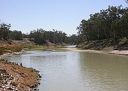
Gunderbooka is believed to be derived from a local Aboriginal word and is also the name of Gundabook Station. [1]
The area occupied by the country was the traditional lands of three groups of Aboriginal tribes.
Living In the west of the County along the Warrego river, were the Gunu people, living in the south along the flood plain of the Darling River were the Barranbidgee people with the Wangoibon tribes living on the adjacent river bank of the Darling River, in what is today Cowper Country.
In the north of the County lived the Manuwari people.
The first Europeans to the County were the expedition of Charles Sturt in 1828. Followed by the expedition of Thomas Mitchell in 1835.
Poet Henry Lawson came to the Country walking from Bourke to Hungerford in 1892.
And another poet, Oglevy coined the phrase "Back of Burke" to describe the remoteness of the northern part of the country during his time working in Engonnia in the years around Federation.
A full list of parishes found within this county; their current LGA and mapping coordinates to the approximate centre of each location is as follows:
The Darling River is the third-longest river in Australia, measuring 1,472 kilometres (915 mi) from its source in northern New South Wales to its confluence with the Murray River at Wentworth. Including its longest contiguous tributaries it is 2,844 km (1,767 mi) long, making it the longest river system in Australia. The Darling River is the outback's most famous waterway.
Sir Thomas Livingstone Mitchell, often called Major Mitchell, was a Scottish surveyor and explorer of Southeastern Australia. He was born in Scotland and served in the British Army during the Peninsular War. In 1827 he took up an appointment as Assistant Surveyor General of New South Wales. The following year he became Surveyor General and remained in this position until his death. Mitchell was knighted in 1839 for his contribution to the surveying of Australia.
Bogan River, a perennial river that is part of the Macquarie–Barwon catchment within the Murray–Darling basin, is located in the central west and Orana regions of New South Wales, Australia.
Menindee is a small town in the far west of New South Wales, Australia, in Central Darling Shire, on the banks of the Darling River, with a sign-posted population of 980 and a 2016 census population of 551. Menindee was the first town to be established on the Darling River. There are two distinct theories for the derivation of the township’s name: (a) from the Barkindji word "minandichi" for the shallow ephemeral lake north-west of the present-day township; (b) from the Barkindji word 'milhthaka', meaning "yolk of an egg".
Bourke is a town in the north-west of New South Wales, Australia. The administrative centre and largest town in Bourke Shire, Bourke is approximately 800 kilometres (500 mi) north-west of the state capital, Sydney, on the south bank of the Darling River. it is also situated:
The Warrego River is an intermittent river that is part of the Darling catchment within the Murray–Darling basin, which is located in South West Queensland and in the Orana region of New South Wales, Australia. The Warrego River is the northernmost tributary of the Darling River.
The Willandra Lakes Region is a World Heritage Site in the Murray region of New South Wales, Australia. The Willandra Lakes Region is the traditional meeting place of the Muthi Muthi, Ngiyampaa and Barkinji Aboriginal tribes. The 240,000-hectare (590,000-acre) area was inscribed on the World Heritage List at the 5th Session of the World Heritage Committee in 1981.
Bourke Shire is a local government area in the Orana region of New South Wales, Australia. The Shire is located adjacent to the Darling River, which is known as the Barwon River upstream from Bourke; and located adjacent to the Mitchell Highway. The northern boundary of the Shire is located adjacent to the border between New South Wales and Queensland. The shire is a wool and beef producing area.
Irrara County is one of the 141 Cadastral divisions of New South Wales. It is located south of the border with Queensland, east of the Paroo River, and west of the Warrego River.
South West Queensland is a remote region in the Australian state of Queensland which covers 319,808 km2 (123,479 sq mi). The region lies to the south of Central West Queensland and west of the Darling Downs and includes the Maranoa district and parts of the Channel Country. The area is noted for its cattle grazing, cotton farming, opal mining and oil and gas deposits.
Landsborough's Blazed Tree is a heritage-listed blazed tree at Mitchell Highway, Bakers Bend, Shire of Murweh, Queensland, Australia. It was marked by William Landsborough. It was added to the Queensland Heritage Register on 18 June 2009.
Landsborough's Blazed Tree is a heritage-listed tree at Mitchell Highway, Charleville, Shire of Murweh, Queensland, Australia. It was marked by William Landsborough. It was added to the Queensland Heritage Register on 18 June 2009.
The Barindji, also written Parrintyi, are an indigenous Australian people of the state of New South Wales. They are to be distinguished from the Paaruntyi, who spoke a similar language but whom they called the spitting people.
The Kula, also known as the Kurnu, were an indigenous Australian people of the state of New South Wales.
Menamurtee located at 31°04′22″S 143°10′00″E, south of White Cliffs, New South Wales in Central Darling Shire is a remote rural locality and civil parish of Yungnulgra County in far North West New South Wales.
Moonamurtie, New South Wales south of White Cliffs, New South Wales in Central Darling Shire is a remote rural locality and civil parish of Yungnulgra County in far North West New South Wales.
Ullollie, New South Wales is a remote rural locality and civil parish of Yungnulgra County in far North West New South Wales.
Canpadore Parish, Yanda County in Bourke Shire is a civil parish of Yanda County, a cadasteral division of New South Wales; a Cadastral division of New South Wales.
Dunlop Parish is a civil parish, of Yanda County, a cadasteral division of New South Wales; a Cadastral division of New South Wales.
Enngonia, formerly known as Eringonia, is a small town in the north-west of New South Wales, Australia, in Bourke Shire, approximately 98 kilometres (61 mi) north of the regional centre of Bourke. The Warrego River runs just to the west of the town. The central street, Belalie Street, is otherwise the Mitchell Highway running north–south.