Windeyer County

Last updated

Map all coordinates using: OpenStreetMap  ·  Google Maps
Download coordinates as: KML  ·  GPX
Windeyer
New South Wales

Windeyer NSW.PNG

Location in New South Wales
Lands administrative divisions around Windeyer:
South Australia Menindee Livingstone
South Australia Windeyer Perry
Hamley (SA) Tara Wentworth

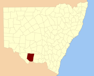
Windeyer County is one of the 141 Cadastral divisions of New South Wales. It is located between the Darling River and the border with South Australia. The Silver City Highway runs through it. Coombah Roadhouse is located there.

Darling River river in Australia

The Darling River is the third longest river in Australia, measuring 1,472 kilometres (915 mi) from its source in northern New South Wales to its confluence with the Murray River at Wentworth, New South Wales. Including its longest contiguous tributaries it is 2,844 km (1,767 mi) long, making it the longest river system in Australia.

South Australia State of Australia

South Australia is a state in the southern central part of Australia. It covers some of the most arid parts of the country. With a total land area of 983,482 square kilometres (379,725 sq mi), it is the fourth-largest of Australia's states and territories by area, and fifth largest by population. It has a total of 1.7 million people, and its population is the second most highly centralised in Australia, after Western Australia, with more than 77 percent of South Australians living in the capital, Adelaide, or its environs. Other population centres in the state are relatively small; Mount Gambier, the second largest centre, has a population of 28,684.
Silver City Highway highway in New South Wales

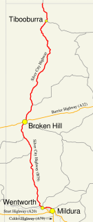
The Silver City Highway is a 683-kilometre-long (424 mi) highway that links Buronga, New South Wales to the Queensland border via Wentworth, Broken Hill, and Tibooburra, in the arid Far West region of New South Wales. A short branch also connects to the Calder Highway on the Victorian border at Curlwaa. This branch is also signed as the Calder Highway, despite legally being part of the Silver City Highway. Parts of the highway north of Broken Hill are unsealed. The namesake of the highway is derived from the moniker for Broken Hill–the "Silver City", which the highway travels through.

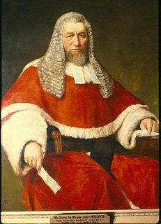
Windeyer County was named in honour of the barrister and politician Richard Windeyer (1806-1847). [1]

Richard Windeyer was a journalist, barrister and Australian politician.

Parishes within this county

A full list of parishes found within this county; their current LGA and mapping coordinates to the approximate centre of each location is as follows:

Local government in Australia is the third tier of government in Australia administered by the states and territories, which in turn are beneath the federal tier. Local government is not mentioned in the Constitution of Australia and two referenda in the 1970s and 1980s to alter the Constitution relating to local government were unsuccessful. Every state government recognises local government in their respective constitutions. Unlike Canada or the United States, there is only one level of local government in each state, with no distinction such as cities and counties.

Parish LGA Coordinates
Abena Unincorporated 33°06′32″S141°57′53″E / 33.10889°S 141.96472°E / -33.10889; 141.96472 (Abena)
Antita Unincorporated 32°49′37″S141°31′19″E / 32.82694°S 141.52194°E / -32.82694; 141.52194 (Antita)
Badham Unincorporated 33°04′24″S141°17′24″E / 33.07333°S 141.29000°E / -33.07333; 141.29000 (Badham)
Barlow Unincorporated 32°42′27″S141°22′21″E / 32.70750°S 141.37250°E / -32.70750; 141.37250 (Barlow)
Barrawanna Wentworth Shire 33°17′36″S142°07′56″E / 33.29333°S 142.13222°E / -33.29333; 142.13222 (Barrawanna)
Barry Unincorporated 32°58′30″S141°06′12″E / 32.97500°S 141.10333°E / -32.97500; 141.10333 (Barry)
Bingalong Unincorporated 32°46′46″S142°11′58″E / 32.77944°S 142.19944°E / -32.77944; 142.19944 (Bingalong)
Bingerry Wentworth Shire 33°17′40″S141°58′54″E / 33.29444°S 141.98167°E / -33.29444; 141.98167 (Bingerry)
Bluebush Unincorporated 32°49′31″S141°05′23″E / 32.82528°S 141.08972°E / -32.82528; 141.08972 (Bluebush)
Boree Wentworth Shire 33°06′33″S141°28′17″E / 33.10917°S 141.47139°E / -33.10917; 141.47139 (Boree)
Buckalow Unincorporated 32°57′40″S141°26′57″E / 32.96111°S 141.44917°E / -32.96111; 141.44917 (Buckalow)
Coombah Unincorporated 32°53′24″S141°37′58″E / 32.89000°S 141.63278°E / -32.89000; 141.63278 (Coombah)
Cuthero Unincorporated 33°03′21″S142°12′23″E / 33.05583°S 142.20639°E / -33.05583; 142.20639 (Cuthero)
Ellerslie Unincorporated 32°48′51″S142°04′46″E / 32.81417°S 142.07944°E / -32.81417; 142.07944 (Ellerslie)
Erreman Wentworth Shire 33°27′09″S142°15′32″E / 33.45250°S 142.25889°E / -33.45250; 142.25889 (Erreman)
Illawla Wentworth Shire 33°21′24″S141°58′00″E / 33.35667°S 141.96667°E / -33.35667; 141.96667 (Illawla)
Kertne Wentworth Shire 33°26′23″S142°06′02″E / 33.43972°S 142.10056°E / -33.43972; 142.10056 (Kertne)
Kilon Wentworth Shire 33°20′19″S142°20′19″E / 33.33861°S 142.33861°E / -33.33861; 142.33861 (Kilon)
Kudgee Unincorporated 32°50′09″S141°42′27″E / 32.83583°S 141.70750°E / -32.83583; 141.70750 (Kudgee)
Mallara Wentworth Shire 33°26′37″S142°28′49″E / 33.44361°S 142.48028°E / -33.44361; 142.48028 (Mallara)
Meroo Unincorporated 33°02′05″S141°38′15″E / 33.03472°S 141.63750°E / -33.03472; 141.63750 (Meroo)
Milang Unincorporated 32°58′14″S141°32′05″E / 32.97056°S 141.53472°E / -32.97056; 141.53472 (Milang)
Mooley Unincorporated 32°54′23″S142°17′28″E / 32.90639°S 142.29111°E / -32.90639; 142.29111 (Mooley)
Mulga Unincorporated 32°44′36″S141°05′40″E / 32.74333°S 141.09444°E / -32.74333; 141.09444 (Mulga)
Mullojama Wentworth Shire 33°24′28″S142°29′23″E / 33.40778°S 142.48972°E / -33.40778; 142.48972 (Mullojama)
Leichhardt Unincorporated 33°03′35″S142°03′05″E / 33.05972°S 142.05139°E / -33.05972; 142.05139 (Leichhardt)
Nadbuck Unincorporated 32°58′14″S141°48′47″E / 32.97056°S 141.81306°E / -32.97056; 141.81306 (Nadbuck)
Nalim Unincorporated 32°53′46″S141°43′08″E / 32.89611°S 141.71889°E / -32.89611; 141.71889 (Nalim)
Ootoowa Wentworth Shire 33°25′47″S141°54′42″E / 33.42972°S 141.91167°E / -33.42972; 141.91167 (Ootoowa)
Orara Wentworth Shire 33°25′38″S142°22′07″E / 33.42722°S 142.36861°E / -33.42722; 142.36861 (Orara)
Palinor Wentworth Shire 33°17′57″S141°50′16″E / 33.29917°S 141.83778°E / -33.29917; 141.83778 (Palinor)
Pearson Unincorporated 32°39′26″S141°04′35″E / 32.65722°S 141.07639°E / -32.65722; 141.07639 (Pearson)
Polia Wentworth Shire 33°16′07″S142°18′45″E / 33.26861°S 142.31250°E / -33.26861; 142.31250 (Polia)
Popilta Wentworth Shire 33°08′20″S141°46′18″E / 33.13889°S 141.77167°E / -33.13889; 141.77167 (Popilta)
Popio Unincorporated 33°05′36″S141°47′34″E / 33.09333°S 141.79278°E / -33.09333; 141.79278 (Popio)
Power Unincorporated 32°57′27″S142°03′06″E / 32.95750°S 142.05167°E / -32.95750; 142.05167 (Power)
Ramleh Unincorporated 32°45′17″S141°50′19″E / 32.75472°S 141.83861°E / -32.75472; 141.83861 (Ramleh)
Spinifex Unincorporated 32°51′13″S141°17′53″E / 32.85361°S 141.29806°E / -32.85361; 141.29806 (Spinifex)
Urntah Wentworth Shire 33°12′02″S142°05′48″E / 33.20056°S 142.09667°E / -33.20056; 142.09667 (Urntah)
Wallara Unincorporated 32°46′01″S141°57′55″E / 32.76694°S 141.96528°E / -32.76694; 141.96528 (Wallara)
Wanneba Unincorporated 32°43′17″S141°42′25″E / 32.72139°S 141.70694°E / -32.72139; 141.70694 (Wanneba)
Wannella Unincorporated 32°55′07″S141°56′27″E / 32.91861°S 141.94083°E / -32.91861; 141.94083 (Wannella)
Whurlie Unincorporated 32°57′18″S142°09′54″E / 32.95500°S 142.16500°E / -32.95500; 142.16500 (Whurlie)
Willotia Unincorporated 32°51′41″S142°18′26″E / 32.86139°S 142.30722°E / -32.86139; 142.30722 (Willotia)
Yaltolka Unincorporated 33°00′25″S142°17′13″E / 33.00694°S 142.28694°E / -33.00694; 142.28694 (Yaltolka)
Yarlalla Wentworth Shire 33°09′29″S141°56′05″E / 33.15806°S 141.93472°E / -33.15806; 141.93472 (Yarlalla)
Yartla Wentworth Shire 33°09′38″S142°11′21″E / 33.16056°S 142.18917°E / -33.16056; 142.18917 (Yartla)

Related Research Articles

Victor Windeyer Australian judge and general

Major General Sir William John Victor Windeyer, was an Australian judge, soldier, educator, and a Justice of the High Court of Australia.

William Charles Windeyer Australian politician and judge

Sir William Charles Windeyer was an Australian politician and judge.

Darbalara, New South Wales Town in New South Wales, Australia

Darbalara is a rural community on the east bank of the junction of the Murrumbidgee River and Tumut River in the Riverina. It is situated by road, about 25 kilometres north east of Gundagai and 25 kilometres south of Coolac.

Townsend County Cadastral in New South Wales, Australia

Townsend County is one of the 141 Cadastral divisions of New South Wales. It is in the south of New South Wales with the Murray River to the south. Deniliquin is located there.

Cowper County Cadastral in New South Wales, Australia

Cowper County, New South Wales is one of the 141 Cadastral divisions of New South Wales.

Gowen County Cadastral in New South Wales, Australia

Gowen County is one of the 141 Cadastral divisions of New South Wales. It is located to the east of the Castlereagh River in the area to the east of Gilgandra, to Coonabarabran in the north-east. This includes land on both sides of the Newell Highway.

Kennedy County Cadastral in New South Wales, Australia

Kennedy County is one of the 141 Cadastral divisions of New South Wales. It is located to the west of the Bogan River in the area around Tottenham and Tullamore.

Oxley County Cadastral in New South Wales, Australia

Oxley County, New South Wales is one of the 141 Cadastral divisions of New South Wales. It is located between the Bogan River on the west, and the Macquarie River on the east. This is the area approximately between Warren and Nyngan.

Margaret Windeyer Australian librarian and feminist

Margaret Windeyer was an Australian librarian and feminist.

Bolivia, New South Wales Town in New South Wales, Australia

Bolivia is a locality on the Northern Tablelands in the New England region of New South Wales, Australia. The remains of the settlement comprises the former Bolivia Hotel, a disused post office, a disused railway siding and a community hall.

Deepwater, New South Wales Town in New South Wales, Australia

Deepwater is a parish and village 40 kilometres north of Glen Innes on the Northern Tablelands, New South Wales, Australia. At the 2006 census, Deepwater had a population of 307, with 489 people in the area.

Windeyer may refer to:

The Coolumbooka River, a perennial river of the Snowy River catchment, is located in the Monaro region of New South Wales, Australia.

Electoral district of County of Durham

The Electoral district of County of Durham was an electorate of the New South Wales Legislative Council at a time when some of its members were elected and the balance were appointed by the Governor. It was named after Durham County, which lies on the north side of the Hunter River.

Gordon Phillip Windeyer is an Australian former track and field athlete who competed in the high jump. He was the gold medallist in the event at the 1974 British Commonwealth Games, setting a games record mark. A three-time winner at the Australian Athletics Championships in the 1970s, he is a former Australian record holder with a best of 2.21 m.

Richard Windeyer Thompson was an Australian politician.

The Windeyer Family (Australia) is a prominent family in the Australian Legal profession. Members of the family include:

Mary Windeyer (1837-1912) community worker

Lady Mary Elizabeth Windeyer was an Australian women's rights campaigner, particularly in relation to women's suffrage in New South Wales, a philanthropist and charity organizer.

Windeyer, New South Wales Town in New South Wales, Australia

Windeyer is a locality in the Mid-Western Regional Council of New South Wales, Australia. It had a population of 176 as of the 2016 census.

References

  1. "Windeyer". Geographical Names Register (GNR) of NSW. Geographical Names Board of New South Wales . Retrieved 11 August 2013.