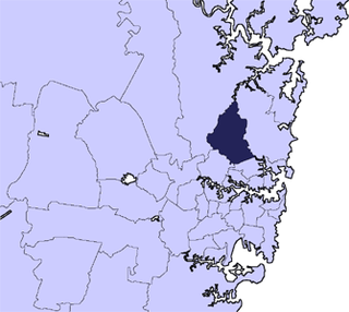
Ku-ring-gai Council is a local government area on the Upper North Shore of Sydney, in the state of New South Wales, Australia. The region is named after the Kuringgai tribe who once inhabited the area.

Killara, is a suburb on the Upper North Shore of Sydney in the state of New South Wales, Australia 14 kilometres (8.7 mi) north-west of the Sydney Central Business District in the local government area of Ku-ring-gai Council. East Killara is a separate suburb and West Killara is a locality within Killara.

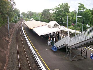
Killara railway station is located on the North Shore line, serving the Sydney suburb of Killara. It is served by Sydney Trains T1 North Shore line services. Killara Railway Station has heritage significance at a local level and is set among expansive gardens, rare in the Sydney Metropolitan train network.
Killara High School is a coeducational public secondary school, located on Koola Avenue in East Killara, Sydney. Established in 1968, Killara High School is one of the highest performing comprehensive non-selective public schools in the state. The success of the school in the Higher School Certificate (HSC) and its reputation as a school with an extensive program of curriculum enrichment make the school highly desirable. Activities such as music, art, dance, drama, debating, sport and strong participation in the Duke of Edinburgh's Award Scheme are included in the co-curricular program. Enrolment rose 21% from 2002 to a population of 1400 students in 2009. It now has 1580 students (2016). Currently, accepted catchment areas include Roseville, West Lindfield, Lindfield, East Lindfield, West Killara, Killara, East Killara, West Gordon and East Gordon.
West Killara is a locality in the suburb of Killara, a suburb located on the Upper North Shore Sydney, in the state of New South Wales, Australia. It is located 14 kilometres north-west of the Sydney Central Business District in the local government area of Ku-ring-gai Council.

East Killara is a suburb on the Upper North Shore of Sydney in the state of New South Wales, Australia. East Killara is located 15 kilometres north of the Sydney Central Business District in the local government area of Ku-ring-gai Council. Killara is a separate suburb to the south-west, which shares the postcode of 2071.

Middle Harbour Creek, a tributary of Middle Harbour, is a youthful tide-dominated, drowned-valley estuary north–west of Sydney Harbour, in Sydney, New South Wales, Australia.

Stewart, is a remote civil parish of Poole County in far North West New South Wales. Stewart is located 10 miles south of Cameron's Corner.

Marra Parish is a Civil Parish of Killara County, New South Wales.

Bonny Parish, New South Wales is a civil parish of Killara County, located in Central Darling Shire.

Towri Parish is a civil parish of Killara County, located in Central Darling Shire at Latitude 31°03′38″S and 144°05′36″E.

Tallandra is a civil parish of Killara County, located in Central Darling Shire at Latitude -31°24′11″S and Longitude 143°40′25″E.

Geigle Parish is a civil parish of Killara County, New South Wales and is located in Central Darling Shire at Latitude -31°23′18″S 143°52′21″E and Longitude 143°52′21″E.

Mount Jack parish is a civil parish of Killara County, located in Central Darling Shire, New South Wales.

Killara Parish in the County of Killara is a civil parish of Killara County, located in Central Darling Shire at Latitude.

Graham Parish in the County of Killara is a civil parish of New South Wales located in Central Darling Shire at Latitude 31°01′12″S and Longitude 143°40′20″E.

Muntawa Parish in the County of Killara is a civil parish of New South Wales located in Central Darling Shire at Latitude 31°01′12″S and Longitude 143°40′20″E.

Moollawoolka is a rural locality and a civil parish of Killara County, in New South Wales


