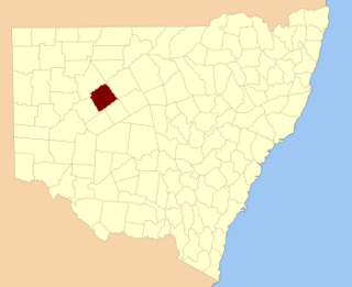
For lands administration purposes, New South Wales is divided into 141 counties, which are further divided into parishes. The counties were first set down in the Colony of New South Wales, which later became the Australian state of New South Wales.

Irrara County is one of the 141 Cadastral divisions of New South Wales. It is located south of the border with Queensland, east of the Paroo River, and west of the Warrego River.

Killara County is one of the 141 Cadastral divisions of New South Wales. The Darling River is its south eastern boundary.

Rankin County is one of the 141 Cadastral divisions of New South Wales. It includes part of the Paroo-Darling National Park. The border to the north-west is the Darling River.

Dunlop Parish is a civil parish, of Yanda County, a cadasteral division of New South Wales; a Cadastral division of New South Wales.
Marra Parish is a Civil Parish of Killara County, New South Wales.

Bonny Parish, New South Wales is a civil parish of Killara County, in Central Darling Shire.

Towri Parish is a civil parish of Killara County, located in Central Darling Shire at Latitude 31°03′38″S and 144°05′36″E.

Tallandra is a civil parish of Killara County, located in Central Darling Shire at Latitude -31°24′11″S and Longitude 143°40′25″E.

Geigle Parish is a civil parish of Killara County, New South Wales and is located in Central Darling Shire at Latitude -31°23′18″S 143°52′21″E and Longitude 143°52′21″E.

Dolora Parish is a civil parish of Killara County, located in Central Darling Shire of NSW at Latitude 31°20′07″S and 143°59′32″E.

Jamison Parish is a civil parish of Killara County, located in Central Darling Shire at 31°15′20″S 143°57′33″E.

Walker Parish is a civil parish of Killara County, located in Central Darling Shire at Latitude 31°03′38″S and 144°05′36″E.
Myali Parish is a civil parish of Killara County, located in Central Darling Shire at Latitude 31°03′38″S and 144°05′36″E.

Killara Parish in the County of Killara is a civil parish of Killara County, located in Central Darling Shire at Latitude.

Hay Parish is a civil parish of Killara County, located in Central Darling Shire at Latitude 31°06′35″S and Longitude144°08′50″E.

Graham Parish in the County of Killara is a civil parish of New South Wales located in Central Darling Shire at Latitude 31°01′12″S and Longitude 143°40′20″E.

Muntawa Parish in the County of Killara is a civil parish of New South Wales located in Central Darling Shire at Latitude 31°01′12″S and Longitude 143°40′20″E.
Pulacarra is a rural locality and civil parish of Killara County located at Latitude -30.730499267 and Longitude 144.070999145

Moollawoolka is a rural locality and a civil parish of Killara County, in New South Wales


