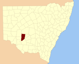
Waljeers County

Last updated

Map all coordinates using: OpenStreetMap  
Download coordinates as: KML  ·  GPX
Waljeers
New South Wales
Waljeers NSW.PNG
Location in New South Wales
Lands administrative divisions around Waljeers:
Manara Mossgiel Mossgiel
Kilfera Waljeers Franklin
Caira Waradgery Nicholson

Waljeers County is one of the 141 Cadastral divisions of New South Wales. It contains the town of Booligal.

The name Waljeers is derived from a local Aboriginal word of the Muthi Muthi tribe. [1]

Indigenous Australians are the Aboriginal and Torres Strait Islander peoples of Australia, descended from groups that existed in Australia and surrounding islands before British colonisation. The time of arrival of the first Indigenous peoples on the continent and nearby islands is a matter of debate among researchers. The earliest conclusively human remains found in Australia are those of Mungo Man LM3 and Mungo Lady, which have been dated to around 50,000 years BP. Recent archaeological evidence from the analysis of charcoal and artefacts revealing human use suggests a date as early as 65,000 BP. Luminescence dating has suggested habitation in Arnhem Land as far back as 60,000 years BP. Genetic research has inferred a date of habitation as early as 80,000 years BP. Other estimates have ranged up to 100,000 years and 125,000 years BP.

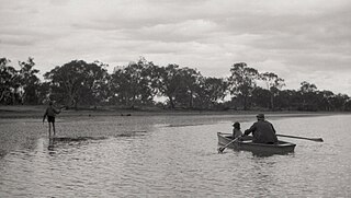
Lake Waljeers is one of largest lakes located north of the Lachlan River and the river crossing at Thellangering.

Fishing on Lake Waljeers Boating on Lake Waljeers.jpg
Fishing on Lake Waljeers

Parishes within this county

A full list of parishes found within this county; their current LGA and mapping coordinates to the approximate centre of each location is as follows:

Local government in Australia

Local government in Australia is the third tier of government in Australia administered by the states and territories, which in turn are beneath the federal tier. Local government is not mentioned in the Constitution of Australia and two referenda in the 1970s and 1980s to alter the Constitution relating to local government were unsuccessful. Every state government recognises local government in their respective constitutions. Unlike Canada or the United States, there is only one level of local government in each state, with no distinction such as cities and counties.

ParishLGACoordinates
Abbotsford Central Darling Shire 33°13′50″S144°19′26″E / 33.23056°S 144.32389°E / -33.23056; 144.32389 (Abbotsford Parish)
Alma Balranald Shire 33°23′34″S144°16′18″E / 33.39278°S 144.27167°E / -33.39278; 144.27167 (Alma Parish)
Annan Carrathool Shire 33°21′04″S144°39′15″E / 33.35111°S 144.65417°E / -33.35111; 144.65417 (Annan Parish)
Arrawatta Balranald Shire 33°43′41″S144°28′14″E / 33.72806°S 144.47056°E / -33.72806; 144.47056 (Arrawatta Parish)
Avondale Carrathool Shire 33°24′02″S144°25′43″E / 33.40056°S 144.42861°E / -33.40056; 144.42861 (Avondale Parish)
Benanimie Hay Shire 33°51′50″S144°49′35″E / 33.86389°S 144.82639°E / -33.86389; 144.82639 (Benanimie Parish)
Billabong Carrathool Shire 33°20′21″S144°25′52″E / 33.33917°S 144.43111°E / -33.33917; 144.43111 (Billabong Parish)
Boondara Carrathool Shire 33°17′23″S144°39′13″E / 33.28972°S 144.65361°E / -33.28972; 144.65361 (Boondara Parish)
Brassbutt Balranald Shire 34°07′21″S144°23′39″E / 34.12250°S 144.39417°E / -34.12250; 144.39417 (Brassbutt Parish)
Buckonyong Balranald Shire 34°06′37″S144°09′18″E / 34.11028°S 144.15500°E / -34.11028; 144.15500 (Buckonyong Parish)
Bulgarbugerygam Balranald Shire 33°42′33″S144°14′07″E / 33.70917°S 144.23528°E / -33.70917; 144.23528 (Bulgarbugerygam Parish)
Bullogal Balranald Shire 33°55′09″S144°31′18″E / 33.91917°S 144.52167°E / -33.91917; 144.52167 (Bullogal Parish)
Bungarry Balranald Shire 34°03′30″S144°17′00″E / 34.05833°S 144.28333°E / -34.05833; 144.28333 (Bungarry Parish)
Campbell Carrathool Shire 33°29′14″S144°30′18″E / 33.48722°S 144.50500°E / -33.48722; 144.50500 (Campbell Parish)
Carngham Hay Shire 33°32′02″S144°37′36″E / 33.53389°S 144.62667°E / -33.53389; 144.62667 (Carngham Parish)
Corrong Balranald Shire 34°09′20″S144°29′39″E / 34.15556°S 144.49417°E / -34.15556; 144.49417 (Corrong Parish)
Culparling Balranald Shire 33°30′33″S144°15′37″E / 33.50917°S 144.26028°E / -33.50917; 144.26028 (Culparling Parish)
Culpataro Balranald Shire 33°37′36″S144°23′51″E / 33.62667°S 144.39750°E / -33.62667; 144.39750 (Culpataro Parish)
Dimboola Balranald Shire 33°57′34″S144°28′54″E / 33.95944°S 144.48167°E / -33.95944; 144.48167 (Dimboola Parish)
Ellisland Balranald Shire 33°16′40″S144°18′56″E / 33.27778°S 144.31556°E / -33.27778; 144.31556 (Ellisland Parish)
Goona Warra Hay Shire 33°59′57″S144°39′07″E / 33.99917°S 144.65194°E / -33.99917; 144.65194 (Goona Warra Parish)
Gregory Balranald Shire 33°56′28″S144°10′41″E / 33.94111°S 144.17806°E / -33.94111; 144.17806 (Gregory Parish)
Howatson Carrathool Shire 33°20′35″S144°46′29″E / 33.34306°S 144.77472°E / -33.34306; 144.77472 (Howatson Parish)
Kingswell Hay Shire 33°34′27″S144°44′50″E / 33.57417°S 144.74722°E / -33.57417; 144.74722 (Kingswell Parish)
Lagan Balranald Shire 34°05′09″S144°23′59″E / 34.08583°S 144.39972°E / -34.08583; 144.39972 (Lagan Parish)
Largs Carrathool Shire 33°21′03″S144°32′01″E / 33.35083°S 144.53361°E / -33.35083; 144.53361 (Largs Parish)
Larnaca Hay Shire 33°35′46″S144°34′53″E / 33.59611°S 144.58139°E / -33.59611; 144.58139 (Larnaca Parish)
Lowan Central Darling Shire 33°14′09″S144°29′03″E / 33.23583°S 144.48417°E / -33.23583; 144.48417 (Lowan Parish)
Marowie Balranald Shire 33°52′18″S144°26′53″E / 33.87167°S 144.44806°E / -33.87167; 144.44806 (Marowie Parish)
Massie Hay Shire 33°42′56″S144°44′18″E / 33.71556°S 144.73833°E / -33.71556; 144.73833 (Massie Parish)
Matamong Balranald Shire 34°03′36″S144°29′21″E / 34.06000°S 144.48917°E / -34.06000; 144.48917 (Matamong Parish)
Mekai Carrathool Shire 33°22′51″S144°45′57″E / 33.38083°S 144.76583°E / -33.38083; 144.76583 (Mekai Parish)
Merrimajeel Hay Shire 33°55′29″S144°37′39″E / 33.92472°S 144.62750°E / -33.92472; 144.62750 (Merrimajeel Parish)
Moodarnong Hay Shire 33°49′29″S144°48′57″E / 33.82472°S 144.81583°E / -33.82472; 144.81583 (Moodarnong Parish)
Mossgiel Central Darling Shire 33°10′56″S144°35′50″E / 33.18222°S 144.59722°E / -33.18222; 144.59722 (Mossgiel Parish)
Mulloga Balranald Shire 34°06′02″S144°16′36″E / 34.10056°S 144.27667°E / -34.10056; 144.27667 (Mulloga Parish)
Murnia Carrathool Shire 33°14′06″S144°48′40″E / 33.23500°S 144.81111°E / -33.23500; 144.81111 (Murnia Parish)
Murra Hay Shire 33°45′38″S144°35′19″E / 33.76056°S 144.58861°E / -33.76056; 144.58861 (Murra Parish)
Nandum Balranald Shire 34°00′49″S144°10′00″E / 34.01361°S 144.16667°E / -34.01361; 144.16667 (Nandum Parish)
Natue Hay Shire 33°50′51″S144°42′21″E / 33.84750°S 144.70583°E / -33.84750; 144.70583 (Natue Parish)
Nyanda Hay Shire 33°48′42″S144°42′51″E / 33.81167°S 144.71417°E / -33.81167; 144.71417 (Nyanda Parish)
Pimpara Balranald Shire 34°11′48″S144°22′20″E / 34.19667°S 144.37222°E / -34.19667; 144.37222 (Pimpara Parish)
Sebastopol Balranald Shire 33°46′04″S144°22′30″E / 33.76778°S 144.37500°E / -33.76778; 144.37500 (Sebastopol Parish)
Simson Central Darling Shire
St Andrew Hay Shire 33°33′06″S144°30′50″E / 33.55167°S 144.51389°E / -33.55167; 144.51389 (St Andrew Parish)
Tarrawong Balranald Shire 33°52′40″S144°13′16″E / 33.87778°S 144.22111°E / -33.87778; 144.22111 (Tarrawong Parish)
Tartoo Hay Shire 33°41′16″S144°38′32″E / 33.68778°S 144.64222°E / -33.68778; 144.64222 (Tartoo Parish)
Tinna Hay Shire 33°47′42″S144°34′57″E / 33.79500°S 144.58250°E / -33.79500; 144.58250 (Tinna Parish)
Toms Lake Hay Shire 33°38′17″S144°45′04″E / 33.63806°S 144.75111°E / -33.63806; 144.75111 (Toms Lake Parish)
Toopruck Balranald Shire 34°13′41″S144°15′47″E / 34.22806°S 144.26306°E / -34.22806; 144.26306 (Toopruck Parish)
Tooralboung Balranald Shire 34°10′16″S144°09′00″E / 34.17111°S 144.15000°E / -34.17111; 144.15000 (Tooralboung Parish)
Trawalla Central Darling Shire 33°12′12″S144°44′25″E / 33.20333°S 144.74028°E / -33.20333; 144.74028 (Trawalla Parish)
Tyson Balranald Shire 33°50′08″S144°22′20″E / 33.83556°S 144.37222°E / -33.83556; 144.37222 (Tyson Parish)
Waljeers Balranald Shire 34°03′10″S144°36′27″E / 34.05278°S 144.60750°E / -34.05278; 144.60750 (Waljeers Parish)
Waverley Carrathool Shire 33°25′08″S144°39′00″E / 33.41889°S 144.65000°E / -33.41889; 144.65000 (Waverley Parish)
Wickham Balranald Shire 33°27′51″S144°16′03″E / 33.46417°S 144.26750°E / -33.46417; 144.26750 (Wickham Parish)
Willandra Central Darling Shire 33°09′18″S144°20′11″E / 33.15500°S 144.33639°E / -33.15500; 144.33639 (Willandra Parish)
Wyunga Balranald Shire 34°00′37″S144°20′14″E / 34.01028°S 144.33722°E / -34.01028; 144.33722 (Wyunga Parish)
Yaloo Hay Shire 33°57′06″S144°44′07″E / 33.95167°S 144.73528°E / -33.95167; 144.73528 (Yaloo Parish)
Yarto Hay Shire 33°27′26″S144°45′58″E / 33.45722°S 144.76611°E / -33.45722; 144.76611 (Yarto Parish)

Related Research Articles

Koraleigh Town in New South Wales, Australia

Koraleigh is a small village in the west of the Riverina region of New South Wales, Australia. The village is on the Murray River and in Murray River Council local government area. Koraleigh is 6 kilometres (3.7 mi) northeast of Nyah, Victoria and 15 kilometres (9.3 mi) south of Tooleybuc.

Yass River river in New South Wales, Australia

The Yass River, a perennial river that is part of the Murrumbidgee catchment within the Murray–Darling basin, is located in the Southern Tablelands and South Western Slopes districts of New South Wales, Australia.

Booligal Town in New South Wales, Australia

Booligal is a village in the Riverina area of western New South Wales (NSW), Australia. It is located on the Cobb Highway, on the Lachlan River north of Hay. Booligal is a part of Hay Shire local government area.

Mossgiel is a location in New South Wales, Australia, in Carrathool Shire. It was a township on the coach route between the Lachlan and Darling Rivers, 50 km southeast of Ivanhoe near the junction with the road to Hillston. The settlement experienced a steady decline during the 20th century. Nowadays Mossgiel township consists of one house and a community hall.

Northumberland County, New South Wales Cadastral in New South Wales, Australia

Northumberland County was one of the original Nineteen Counties in New South Wales and is now one of the 141 Cadastral divisions of New South Wales. It included the area to the north of Broken Bay, including Lake Macquarie and Newcastle. It was bounded by the part of the Hawkesbury River to the south, the Macdonald River to the south-west, and the Hunter River to the north.

The Cordeaux River, a perennial river of the Hawkesbury-Nepean catchment, is located in the Southern Highlands and Macarthur regions of New South Wales, Australia.

Telegherry River river in New South Wales, Australia

Telegherry River, a perennial river of the Mid-Coast Council system, is located in the Mid North Coast and Upper Hunter regions of New South Wales, Australia.

The Branch River, a watercourse of the Mid-Coast Council system, is located in the Mid North Coast and Upper Hunter regions of New South Wales, Australia.

Wallamba River, a watercourse of the Mid-Coast Council system, is located in the Mid North Coast district of New South Wales, Australia.

Wallingat River, a watercourse of the Mid-Coast Council system, is located in the Mid North Coast district of New South Wales, Australia.

Wang Wauk River, a perennial river of the Great Lakes system, is located in the Mid North Coast region of New South Wales, Australia.

Wards River, a mostly perennial river of the Mid-Coast Council system, is located in the Mid North Coast and Upper Hunter regions of New South Wales, Australia.

The Wyong River is a perennial river that is located in the Central Coast region of New South Wales, Australia.

Yowaka River, a perennial river of the Pambula River catchment, is located in the South Coast region of New South Wales, Australia.

Muthi Muthi

The Muthi Muthi people are an Aboriginal group of the Kulin Nation whose traditional lands are located in the Northern Riverina and Far West regions of New South Wales. Clans of the Mathi include the Kunjie Kunjie, Yita Yita, Baingo, Tati Tati and Berriat (Parindji).

Adelong Creek river in New South Wales, Australia

The Adelong Creek, a perennial river that is part of the Murrumbidgee catchment within the Murray–Darling basin, is located in the South West Slopes, and Riverina regions of New South Wales, Australia.

Yandumblin, New South Wales

Yandumblin is a rural locality of Hay Shire Council and a civil parish of Nicholson County, in the Riverina region of Australia.
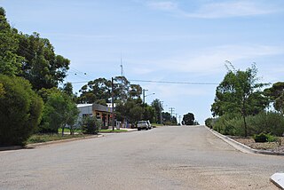
Waljeers, Waljeers Parish of Waljeers County, New South Wales, Australia

Waljeers is a Civil parish of Waljeers County in the Riverina area of Far West, New South Wales.

Goona Warra, Waljeers Civil parish in New South Wales

Goona Warra is a civil parish of Waljeers County in the Riverina area Far West, New South Wales.

Campbell Parish is a Civil parish of Waljeers County between Ivanhoe, New South Wales and Booligal, New South Wales on the Hay Plain. The parish is on the Lauchlin River at 33°29'14.0"S 144°30'18.0"E.
References

  1. "Waljeers". Geographical Names Register (GNR) of NSW. Geographical Names Board of New South Wales . Retrieved 11 August 2013. OOjs UI icon edit-ltr-progressive.svg