Menindee County

Last updated
Map all coordinates using: OpenStreetMap  ·  Google Maps
Download coordinates as: KML  ·  GPX
Menindee
New South Wales

Menindee NSW.PNG

Location in New South Wales
Lands administrative divisions around Menindee:
South Australia Yancowinna Tandora
South Australia Menindee Livingstone
South Australia Windeyer Perry

Menindee County is one of the 141 Cadastral divisions of New South Wales. It is located between the Darling River and the South Australian border. Menindee is at its north-eastern edge. The Menindee Lakes are located there.

Darling River river in Australia

The Darling River is the third longest river in Australia, measuring 1,472 kilometres (915 mi) from its source in northern New South Wales to its confluence with the Murray River at Wentworth, New South Wales. Including its longest contiguous tributaries it is 2,844 km (1,767 mi) long, making it the longest river system in Australia.

Menindee, New South Wales Town in New South Wales, Australia

Menindee, frequently but erroneously spelled "Menindie", is a small town in the far west of New South Wales, Australia, in Central Darling Shire, on the banks of the Darling River, with a sign-posted population of 980 and a 2016 census population of 551.

Menindee Lakes

The Menindee Lakes is a chain of shallow ephemeral freshwater lakes connected to the Darling River to form a storage system. The lakes lie in the far west region of New South Wales, Australia, near the town of Menindee.

The name Menindee is of unknown origin. [1]

Parishes within this county

A full list of parishes found within this county; their current LGA and mapping coordinates to the approximate centre of each location is as follows:

Local government in Australia is the third tier of government in Australia administered by the states and territories, which in turn are beneath the federal tier. Local government is not mentioned in the Constitution of Australia and two referenda in the 1970s and 1980s to alter the Constitution relating to local government were unsuccessful. Every state government recognises local government in their respective constitutions. Unlike Canada or the United States, there is only one level of local government in each state, with no distinction such as cities and counties.

Parish LGA Coordinates
Bintullia Unincorporated 32°40′32″S142°11′08″E / 32.67556°S 142.18556°E / -32.67556; 142.18556 (Bintullia)
Buckalow East Unincorporated 32°38′22″S141°15′12″E / 32.63944°S 141.25333°E / -32.63944; 141.25333 (Buckalow East)
Buckalow West Unincorporated 32°33′51″S141°05′00″E / 32.56417°S 141.08333°E / -32.56417; 141.08333 (Buckalow West)
Buckalow Unincorporated 32°33′35″S141°13′43″E / 32.55972°S 141.22861°E / -32.55972; 141.22861 (Buckalow)
Burta Unincorporated 32°30′00″S141°04′59″E / 32.50000°S 141.08306°E / -32.50000; 141.08306 (Burta)
Caari Unincorporated 32°29′07″S141°48′34″E / 32.48528°S 141.80944°E / -32.48528; 141.80944 (Caari)
Cawndilla Central Darling Shire 32°27′28″S142°11′24″E / 32.45778°S 142.19000°E / -32.45778; 142.19000 (Cawndilla)
Coonalhugga Central Darling Shire 32°41′36″S142°19′44″E / 32.69333°S 142.32889°E / -32.69333; 142.32889 (Coonalhugga)
Coultra Unincorporated 32°15′35″S141°04′04″E / 32.25972°S 141.06778°E / -32.25972; 141.06778 (Coultra)
Doon Unincorporated 32°20′27″S141°12′56″E / 32.34083°S 141.21556°E / -32.34083; 141.21556 (Doon)
Enmore Unincorporated unknown
Ita Unincorporated 32°39′33″S141°26′12″E / 32.65917°S 141.43667°E / -32.65917; 141.43667 (Ita)
Kinchega Central Darling Shire 32°31′07″S142°19′39″E / 32.51861°S 142.32750°E / -32.51861; 142.32750 (Kinchega)
Laidley Central Darling Shire 32°25′10″S142°18′07″E / 32.41944°S 142.30194°E / -32.41944; 142.30194 (Laidley)
Mitta Unincorporated 32°41′56″S142°00′07″E / 32.69889°S 142.00194°E / -32.69889; 142.00194 (Mitta)
Mundybah Unincorporated 32°19′53″S141°55′44″E / 32.33139°S 141.92889°E / -32.33139; 141.92889 (Mundybah)
Naloira Central Darling Shire 32°34′22″S142°20′32″E / 32.57278°S 142.34222°E / -32.57278; 142.34222 (Naloira)
Nettlegoe Unincorporated 32°33′10″S142°00′55″E / 32.55278°S 142.01528°E / -32.55278; 142.01528 (Nettlegoe)
Paringi Unincorporated 32°22′03″S142°08′06″E / 32.36750°S 142.13500°E / -32.36750; 142.13500 (Paringi)
Perry Central Darling Shire 32°20′55″S142°21′31″E / 32.34861°S 142.35861°E / -32.34861; 142.35861 (Perry)
Pinnelco Central Darling Shire 32°37′41″S142°18′37″E / 32.62806°S 142.31028°E / -32.62806; 142.31028 (Pinnelco)
Putta Unincorporated 32°25′28″S141°12′03″E / 32.42444°S 141.20083°E / -32.42444; 141.20083 (Putta)
Rantyga Unincorporated 32°18′09″S141°36′13″E / 32.30250°S 141.60361°E / -32.30250; 141.60361 (Rantyga)
Tandou Central Darling Shire 32°32′32″S142°12′05″E / 32.54222°S 142.20139°E / -32.54222; 142.20139 (Tandou)
Waneba Unincorporated 32°37′08″S141°37′28″E / 32.61889°S 141.62444°E / -32.61889; 141.62444 (Waneba)
Wanga Unincorporated 32°26′05″S141°18′54″E / 32.43472°S 141.31500°E / -32.43472; 141.31500 (Wanga)
Wendi Unincorporated 32°30′19″S141°35′55″E / 32.50528°S 141.59861°E / -32.50528; 141.59861 (Wendi)
West Mitta Unincorporated 32°40′44″S141°48′33″E / 32.67889°S 141.80917°E / -32.67889; 141.80917 (West Mitta)
West Wendi Unincorporated 32°25′59″S141°27′09″E / 32.43306°S 141.45250°E / -32.43306; 141.45250 (West Wendi)

Related Research Articles

Kinchega National Park Protected area in New South Wales, Australia

The Kinchega National Park is a protected national park that is located in the Far West region of New South Wales, in eastern Australia. The 44,259-hectare (109,370-acre) national park is located approximately 840 kilometres (520 mi) west of Sydney and 111 kilometres (69 mi) south-east of Broken Hill. The park adjoins the town of Menindee. The eastern edge of the Kinchega National Park is formed by the Darling River.

The Division of Barrier was an Australian electoral division in the state of New South Wales. The division was proclaimed in 1900, and was one of the original 65 divisions to be contested at the first federal election. It was named for the Barrier Ranges near the city of Broken Hill in western New South Wales. In 1901, it included Broken Hill, Wilcannia, White Cliffs and Tibooburra and the surrounding pastoral areas. In 1906, it gained Menindee, Wentworth from Riverina and in 1913, it gained Balranald and Deniliquin from Riverina. It was abolished in 1922 with Broken Hill, Wentworth and Balranald being transferred to Darling and Deniliquin transferred to Riverina. It was a very safe seat for the Australian Labor Party, although both its members left the ALP at the end their terms: Josiah Thomas to join the Nationalists, and Michael Considine to sit as an independent.

Central Darling Shire Local government area in New South Wales, Australia

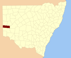
Central Darling Shire is a local government area in the Far West region of New South Wales, Australia. The Shire is located adjacent to the Barrier Highway. Central Darling Shire was constituted in 1959 and at 53,511 square kilometres (20,661 sq mi), it is the largest incorporated local government area in New South Wales.

Livingstone County, New South Wales Cadastral in New South Wales, Australia

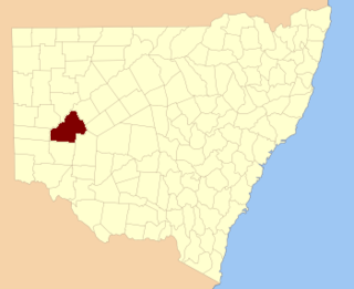
Livingstone County is one of the 141 Cadastral divisions of New South Wales. The Darling River is the western and north-western boundary, near Menindee.

Tandora County Cadastral in New South Wales, Australia

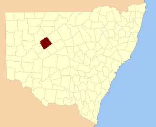
Tandora County is one of the 141 Cadastral divisions of New South Wales. It is located to the north west of the Darling River, to the area to the north Menindee.

Outback Rugby League

The Outback Rugby League Cup is a New South Wales Country Rugby League (NSWCRL) Group Competition which is based in Broken Hill in the far west of New South Wales and surrounding districts such as Wilcannia and Menindee.

Menindee railway station

Menindee railway station is located on the Broken Hill line in New South Wales, Australia. It serves the town of Menindee.

Titabaira, New South Wales

Titabaira, New South Wales is a remote rural locality of Central Darling Shire and civil parish of Tandora County located at 32°15′01″S 142°28′48″E on the Menindee Lakes. It is located to the north west of the Darling River, to the area to the north of Menindee.

Tandore, New South Wales

Tandore, New South Wales is a remote rural locality of Central Darling Shire and civil parish of Tandora County. It is located on the Menindee Lakes to the north west of the Darling River, to the area to the north of Menindee.

Weinteriga, New South Wales

Weinteriga, New South Wales is a remote rural locality of Central Darling Shire and civil parish of Tandora County. It is located on the Menindee Lakes to the north west of the Darling River, to the area to the north of Menindee.

Hume Parish, New South Wales

Hume Parish, New South Wales is a remote rural locality of Central Darling Shire and civil parish of Tandora County in far West New South Wales. The Parish is located at 32°18′43″S 142°22′37″E on Lake Menindee, on the out-skirts of Menindee township.

Quondong, New South Wales

Quondong, New South Wales is a remote rural locality and civil parish of Tandora County, a cadasteral division of far North West New South Wales.

Parish of Budda

Budda Parish in Cobar Shire is a civil parish of Rankin County,; a Cadastral division of New South Wales.

Parish of Tankarook

Tankarrok Parish in Cobar Shire is a civil parish of Rankin County,; a Cadastral division of New South Wales.

Parish of Buckinbe

Buckinbe Parish in Cobar Shire is a civil parish of Rankin County,; a Cadastral division of New South Wales.

Parish of Wallandra

Wallandra Parish in Cobar Shire is a civil parish of Rankin County, a Cadastral division of New South Wales. The Parish is on the Darling River upstream of Wilcannia, New South Wales and is located at 30°55′11″S 144°33′51″E. The only town of the parish is Tilpa, New South Wales.

References

  1. "Menindee County". Geographical Names Register (GNR) of NSW. Geographical Names Board of New South Wales.