Blaxland County

Last updated

Map all coordinates using: OpenStreetMap  
Download coordinates as: KML
Blaxland
New South Wales
Blaxland NSW.PNG
Location in New South Wales
Lands administrative divisions around Blaxland:
Mouramba Mouramba Flinders
Mossgiel Blaxland Cunningham
Franklin Dowling Gipps

Blaxland County is one of the 141 Cadastral divisions of New South Wales. It is bounded to the south by the Lachlan River and a small part of Waverley Creek. It includes Mount Hope and the Nombinnie Nature Reserve.

Blaxland County was named in honour of John Blaxland, landowner and merchant. [1]

Parishes within this county

A full list of parishes found within this county; their current LGA and mapping coordinates to the approximate centre of each location is as follows:

ParishLGACoordinates
Back Roto Carrathool Shire 33°07′59″S145°33′45″E / 33.13306°S 145.56250°E / -33.13306; 145.56250 (Back Roto)
Back Wallandra Carrathool Shire 33°08′14″S145°42′33″E / 33.13722°S 145.70917°E / -33.13722; 145.70917 (Back Wallandra)
Back Whoey Cobar Shire 33°06′42″S146°12′06″E / 33.11167°S 146.20167°E / -33.11167; 146.20167 (Back Whoey)
Beauport Cobar Shire 32°53′22″S146°35′59″E / 32.88944°S 146.59972°E / -32.88944; 146.59972 (Beauport)
Bogalo Cobar Shire 32°42′10″S146°14′02″E / 32.70278°S 146.23389°E / -32.70278; 146.23389 (Bogalo)
Bogalo South Cobar Shire 32°46′37″S146°13′38″E / 32.77694°S 146.22722°E / -32.77694; 146.22722 (Bogalo South)
Booberoi Cobar Shire 33°03′34″S146°31′00″E / 33.05944°S 146.51667°E / -33.05944; 146.51667 (Booberoi)
Boothumble Cobar Shire 32°55′46″S146°13′04″E / 32.92944°S 146.21778°E / -32.92944; 146.21778 (Boothumble)
Buckley Carrathool Shire 33°18′51″S145°44′41″E / 33.31417°S 145.74472°E / -33.31417; 145.74472 (Buckley)
Bundure Cobar Shire 32°39′56″S146°04′56″E / 32.66556°S 146.08222°E / -32.66556; 146.08222 (Bundure)
Bundure South Cobar Shire 32°44′10″S146°04′14″E / 32.73611°S 146.07056°E / -32.73611; 146.07056 (Bundure South)
Burthong Cobar Shire 32°24′53″S146°17′54″E / 32.41472°S 146.29833°E / -32.41472; 146.29833 (Burthong)
Burthong South Cobar Shire 32°30′37″S146°15′36″E / 32.51028°S 146.26000°E / -32.51028; 146.26000 (Burthong South)
Cagellico Cobar Shire 33°00′17″S146°16′13″E / 33.00472°S 146.27028°E / -33.00472; 146.27028 (Cagellico)
Calytria Cobar Shire unknown
Coan Cobar Shire 32°45′21″S145°43′40″E / 32.75583°S 145.72778°E / -32.75583; 145.72778 (Coan)
Cobram Cobar Shire 32°32′08″S146°03′26″E / 32.53556°S 146.05722°E / -32.53556; 146.05722 (Cobram)
Coree Cobar Shire 32°40′28″S145°56′04″E / 32.67444°S 145.93444°E / -32.67444; 145.93444 (Coree)
Creamy Hills Cobar Shire 32°58′57″S146°28′15″E / 32.98250°S 146.47083°E / -32.98250; 146.47083 (Creamy Hills)
Currawallah Cobar Shire 32°40′36″S146°24′17″E / 32.67667°S 146.40472°E / -32.67667; 146.40472 (Currawallah)
East Gilgunnia Cobar Shire 32°27′59″S145°57′44″E / 32.46639°S 145.96222°E / -32.46639; 145.96222 (East Gilgunnia)
Eeramaran Cobar Shire 32°28′54″S146°21′04″E / 32.48167°S 146.35111°E / -32.48167; 146.35111 (Eeramaran)
Eribendery Cobar Shire 33°07′45″S146°21′18″E / 33.12917°S 146.35500°E / -33.12917; 146.35500 (Eribendery)
Euabalong Cobar Shire 33°05′09″S146°25′10″E / 33.08583°S 146.41944°E / -33.08583; 146.41944 (Euabalong)
Gilgunnia Cobar Shire unknown
Gonn Cobar Shire 32°52′17″S145°44′29″E / 32.87139°S 145.74139°E / -32.87139; 145.74139 (Gonn)
Gooan Cobar Shire 32°30′04″S145°56′50″E / 32.50111°S 145.94722°E / -32.50111; 145.94722 (Gooan)
Gounelgerie Carrathool Shire 32°58′00″S145°31′58″E / 32.96667°S 145.53278°E / -32.96667; 145.53278 (Gounelgerie)
Guagong Cobar Shire unknown
Guapa Cobar Shire 32°33′24″S146°13′37″E / 32.55667°S 146.22694°E / -32.55667; 146.22694 (Guapa)
Guapa West Cobar Shire 32°37′25″S146°07′45″E / 32.62361°S 146.12917°E / -32.62361; 146.12917 (Guapa West)
Gunnagi Carrathool Shire 33°11′08″S145°28′56″E / 33.18556°S 145.48222°E / -33.18556; 145.48222 (Gunnagi)
Hyandra Cobar Shire 33°10′36″S146°12′04″E / 33.17667°S 146.20111°E / -33.17667; 146.20111 (Hyandra)
Illewong Cobar Shire 32°53′01″S146°20′15″E / 32.88361°S 146.33750°E / -32.88361; 146.33750 (Illewong)
Illewong West Cobar Shire 32°53′27″S146°12′36″E / 32.89083°S 146.21000°E / -32.89083; 146.21000 (Illewong West)
Ina Cobar Shire 33°01′43″S146°02′55″E / 33.02861°S 146.04861°E / -33.02861; 146.04861 (Ina)
Jundrie Carrathool Shire 33°19′34″S146°00′07″E / 33.32611°S 146.00194°E / -33.32611; 146.00194 (Jundrie)
Keginni Cobar Shire 32°36′10″S145°39′04″E / 32.60278°S 145.65111°E / -32.60278; 145.65111 (Keginni)
Killeen Cobar Shire 32°29′37″S145°47′28″E / 32.49361°S 145.79111°E / -32.49361; 145.79111 (Killeen)
Killeen South Cobar Shire 32°33′18″S145°46′14″E / 32.55500°S 145.77056°E / -32.55500; 145.77056 (Killeen South)
Mahurangi Cobar Shire 33°02′44″S145°40′46″E / 33.04556°S 145.67944°E / -33.04556; 145.67944 (Mahurangi)
Mahurangi East Cobar Shire 33°02′52″S145°46′01″E / 33.04778°S 145.76694°E / -33.04778; 145.76694 (Mahurangi East)
Manopa Carrathool Shire 33°00′24″S145°35′50″E / 33.00667°S 145.59722°E / -33.00667; 145.59722 (Manopa)
Marobee Cobar Shire 32°33′51″S146°25′27″E / 32.56417°S 146.42417°E / -32.56417; 146.42417 (Marobee)
Marobee East Cobar Shire 32°36′43″S146°32′07″E / 32.61194°S 146.53528°E / -32.61194; 146.53528 (Marobee East)
Marooba Carrathool Shire 32°51′39″S145°37′11″E / 32.86083°S 145.61972°E / -32.86083; 145.61972 (Marooba)
Matakana Cobar Shire 32°57′34″S145°53′25″E / 32.95944°S 145.89028°E / -32.95944; 145.89028 (Matakana)
Matakana South Cobar Shire 33°04′09″S145°53′25″E / 33.06917°S 145.89028°E / -33.06917; 145.89028 (Matakana South)
Meldior Cobar Shire 32°51′43″S146°28′46″E / 32.86194°S 146.47944°E / -32.86194; 146.47944 (Meldior)
Mellelea Cobar Shire 33°02′25″S146°10′56″E / 33.04028°S 146.18222°E / -33.04028; 146.18222 (Mellelea)
Merrimerriwa Cobar Shire 32°43′23″S145°35′52″E / 32.72306°S 145.59778°E / -32.72306; 145.59778 (Merrimerriwa)
Moora Cobar Shire 32°58′58″S146°21′44″E / 32.98278°S 146.36222°E / -32.98278; 146.36222 (Moora)
Mordie Carrathool Shire 32°54′58″S145°31′44″E / 32.91611°S 145.52889°E / -32.91611; 145.52889 (Mordie)
Mount Allen Cobar Shire 32°44′02″S145°52′49″E / 32.73389°S 145.88028°E / -32.73389; 145.88028 (Mount Allen)
Mount Hope Cobar Shire 32°53′33″S145°51′40″E / 32.89250°S 145.86111°E / -32.89250; 145.86111 (Mount Hope)
Mount Solitary Cobar Shire 32°54′23″S145°56′45″E / 32.90639°S 145.94583°E / -32.90639; 145.94583 (Mount Solitary)
Mulga Cobar Shire 32°59′00″S146°02′34″E / 32.98333°S 146.04278°E / -32.98333; 146.04278 (Mulga)
Nombinnie Cobar Shire 32°47′28″S145°46′49″E / 32.79111°S 145.78028°E / -32.79111; 145.78028 (Nombinnie)
North Hyandra Carrathool Shire 33°13′44″S146°00′35″E / 33.22889°S 146.00972°E / -33.22889; 146.00972 (North Hyandra)
North Peak Cobar Shire 32°27′21″S146°09′26″E / 32.45583°S 146.15722°E / -32.45583; 146.15722 (North Peak)
Oneida Carrathool Shire 33°05′54″S145°51′31″E / 33.09833°S 145.85861°E / -33.09833; 145.85861 (Oneida)
Roto Carrathool Shire 33°10′25″S145°34′26″E / 33.17361°S 145.57389°E / -33.17361; 145.57389 (Roto)
Salamagundia Carrathool Shire 33°09′43″S145°54′32″E / 33.16194°S 145.90889°E / -33.16194; 145.90889 (Salamagundia)
South Peak Cobar Shire 32°24′04″S145°59′48″E / 32.40111°S 145.99667°E / -32.40111; 145.99667 (South Peak)
South Thule Cobar Shire 32°24′10″S145°42′27″E / 32.40278°S 145.70750°E / -32.40278; 145.70750 (South Thule)
South Yackerboon Cobar Shire 32°24′51″S145°49′47″E / 32.41417°S 145.82972°E / -32.41417; 145.82972 (South Yackerboon)
Tallebung Cobar Shire 32°40′06″S146°32′18″E / 32.66833°S 146.53833°E / -32.66833; 146.53833 (Tallebung)
Tara Cobar Shire 32°35′18″S146°18′31″E / 32.58833°S 146.30861°E / -32.58833; 146.30861 (Tara)
Tara South Cobar Shire 32°37′39″S146°18′10″E / 32.62750°S 146.30278°E / -32.62750; 146.30278 (Tara South)
Tarcombe Cobar Shire 32°23′41″S146°05′54″E / 32.39472°S 146.09833°E / -32.39472; 146.09833 (Tarcombe)
Tarran Cobar Shire 32°27′08″S146°28′00″E / 32.45222°S 146.46667°E / -32.45222; 146.46667 (Tarran)
Thule Cobar Shire 32°20′44″S145°42′57″E / 32.34556°S 145.71583°E / -32.34556; 145.71583 (Thule)
Torcobil Carrathool Shire 33°15′10″S145°47′00″E / 33.25278°S 145.78333°E / -33.25278; 145.78333 (Torcobil)
Ulalu Carrathool Shire 33°08′40″S146°02′14″E / 33.14444°S 146.03722°E / -33.14444; 146.03722 (Ulalu)
Ulambong Cobar Shire unknown
Ulumba Carrathool Shire 32°48′20″S145°35′05″E / 32.80556°S 145.58472°E / -32.80556; 145.58472 (Ulumba)
Urambie Cobar Shire 32°46′30″S146°27′27″E / 32.77500°S 146.45750°E / -32.77500; 146.45750 (Urambie)
Urambie East Cobar Shire 32°45′30″S146°34′15″E / 32.75833°S 146.57083°E / -32.75833; 146.57083 (Urambie East)
Uranaway Carrathool Shire 33°18′10″S145°53′18″E / 33.30278°S 145.88833°E / -33.30278; 145.88833 (Uranaway)
Victor Cobar Shire 32°38′38″S145°49′44″E / 32.64389°S 145.82889°E / -32.64389; 145.82889 (Victor)
Wagga Cobar Shire 32°37′44″S145°45′21″E / 32.62889°S 145.75583°E / -32.62889; 145.75583 (Wagga)
Walla Wollong Cobar Shire 32°49′10″S146°22′03″E / 32.81944°S 146.36750°E / -32.81944; 146.36750 (Walla Wollong)
Wallandra Carrathool Shire 33°11′19″S145°40′32″E / 33.18861°S 145.67556°E / -33.18861; 145.67556 (Wallandra)
Warbreccan Cobar Shire 32°24′36″S145°34′43″E / 32.41000°S 145.57861°E / -32.41000; 145.57861 (Warbreccan)
Warrabillong Cobar Shire 32°48′50″S146°32′08″E / 32.81389°S 146.53556°E / -32.81389; 146.53556 (Warrabillong)
West Uabba Carrathool Shire 33°15′30″S146°00′03″E / 33.25833°S 146.00083°E / -33.25833; 146.00083 (West Uabba)
Whoey Cobar Shire 33°10′35″S146°18′15″E / 33.17639°S 146.30417°E / -33.17639; 146.30417 (Whoey)
Wilga Carrathool Shire 33°12′28″S145°47′35″E / 33.20778°S 145.79306°E / -33.20778; 145.79306 (Wilga)
Yackerboon Cobar Shire 32°23′14″S145°48′18″E / 32.38722°S 145.80500°E / -32.38722; 145.80500 (Yackerboon)
Yara Cobar Shire 32°49′44″S146°02′25″E / 32.82889°S 146.04028°E / -32.82889; 146.04028 (Yara)
Yara East Cobar Shire 32°54′53″S146°06′17″E / 32.91472°S 146.10472°E / -32.91472; 146.10472 (Yara East)
Yathong Cobar Shire unknown

Related Research Articles

Blue Mountains (New South Wales) Region in New South Wales, Australia

The Blue Mountains are a mountainous region and a mountain range located in New South Wales, Australia. The region borders on Sydney's metropolitan area, its foothills starting about 50 kilometres (31 mi) west of centre of the state capital, close to Penrith on the outskirts of Greater Sydney region. The public's understanding of the extent of the Blue Mountains is varied, as it forms only part of an extensive mountainous area associated with the Great Dividing Range. Officially the Blue Mountains region is bounded by the Nepean and Hawkesbury rivers in the east, the Coxs River and Lake Burragorang to the west and south, and the Wolgan and Colo rivers to the north. Geologically, it is situated in the central parts of the Sydney Basin.

Gregory Blaxland

Gregory Blaxland was an English pioneer farmer and explorer in Australia, noted especially for initiating and co-leading the first successful crossing of the Blue Mountains by European settlers.

William Lawson (explorer)

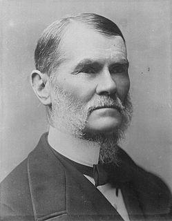
William Lawson, MLC was an English-born Australian explorer, land owner, grazier and politician who migrated to Sydney, New South Wales in 1800. Along with his close friends and colleagues Gregory Blaxland and William Wentworth, he pioneered the first successful crossing of the Blue Mountains by European settlers.

Division of Blaxland Australian federal electoral division

The Division of Blaxland is an Australian electoral division in the state of New South Wales.

Blaxland, New South Wales Town in New South Wales, Australia

Blaxland is a town in the Blue Mountains of New South Wales, Australia. Blaxland is located 70 kilometres west of Sydney in the local government area of the City of Blue Mountains. It is at an altitude of 234 metres and borders the townships of Glenbrook, Mount Riverview and Warrimoo.

South Creek (New South Wales)

The South Creek or Wianamatta, a creek that is part of the Hawkesbury-Nepean catchment, is located on the Cumberland Plain, also referred to as Greater Western Sydney, New South Wales, Australia.

George Evans (explorer)

George William Evans was a surveyor and early explorer in the Colony of New South Wales. Evans was born in Warwick, England, migrating to Australia in October 1802.

William Forster (Australian politician)

William Forster was a pastoral squatter, colonial British politician, Premier of New South Wales from 27 October 1859 to 9 March 1860, and poet.

Blaxland railway station

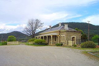
Blaxland railway station is located on the Main Western line in New South Wales, Australia. It serves the Blue Mountains suburb of Blaxland opening on 11 July 1867 as Wascoes, being renamed Blaxland on 21 April 1879.

1813 in Australia featured a number of important developments. Gregory Blaxland, William Lawson and William Charles Wentworth crossed the Blue Mountains which opened up the interior of New South Wales for European settlement. John and Elizabeth Macarthur sent the first wool exports from their properties.

Broke, New South Wales Town in New South Wales, Australia

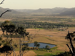
Broke is a village of approximately 292 people in the Hunter Region of New South Wales, Australia in Singleton Shire. It is located 157 kilometres (98 mi) to the north of Sydney on the original early colonial road from Sydney to Singleton.

John Blaxland (explorer)

John Blaxland was a pioneer settler and explorer in Australia.

Helen Blaxland

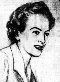
Dame Helen Frances Blaxland, DBE was an Australian charity fundraiser, heritage conservationist, skilful flower arranger and nonfiction writer.

Bowenfels, New South Wales Town in New South Wales, Australia

Bowenfels is a small town on the western outskirts of Lithgow, New South Wales, Australia.

Mount York

Mount York, a mountain in the western region of the Explorer Range, part of the Blue Mountains Range that is a spur off the Great Dividing Range, is located approximately 150 kilometres (93 mi) west of Sydney, just outside Mount Victoria in New South Wales, Australia. Mount York has an elevation of 1,061 metres (3,481 ft) AHD  and is a projection of the Blue Mountains dissected plateau, creating a promontory of the western escarpment with a minor rise at its summit.

Nymboida, New South Wales Town in New South Wales, Australia

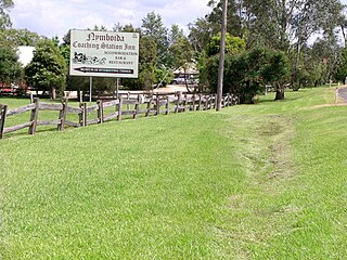
Nymboida is a rural village in the Northern Rivers region of New South Wales, Australia. It is about 21 kilometres south-west of Coutts Crossing, 44 kilometres south-west of Grafton and approximately 687 km north of Sydney. Nymboida is close to the challenging and popular white water rafting waters of the Nymboida River along the Armidale–Grafton Road. The village is in the Clarence Valley Council local government area.

Blaxlands Corner, New South Wales New South Wales, Australia

Blaxlands Corner is a locality on the North Shore of Sydney in the state of New South Wales, Australia. Blaxlands Corner is at the intersection of Longueville Road, Northwood Road, and River Road West, in the southern part of Lane Cove adjacent to Longueville. It contains the Longueville Sporting Club, three petrol stations, a bottle shop, a veterinary clinic, a travel and cruise agency and a couple of other small stores.

1813 crossing of the Blue Mountains Australian mountaineering expedition

The 1813 crossing of the Blue Mountains was the expedition led by Gregory Blaxland, William Lawson and William Charles Wentworth, which became the first successful crossing of the Blue Mountains in New South Wales by European settlers. The crossing enabled the settlers to access and use the land west of the mountains for farming, and made possible the establishment of Australia's first inland settlement at Bathurst.

Blaxland Creek, a watercourse that is part of the Hawkesbury–Nepean catchment, is located in Greater Western Sydney, Australia.

Blaxland Shire was a local government area in the Central West region of New South Wales, Australia.

References

  1. "Blaxland County". Geographical Names Register (GNR) of NSW. Geographical Names Board of New South Wales. OOjs UI icon edit-ltr-progressive.svg