
Chippendale is a small inner-city suburb of Sydney, New South Wales, Australia on the southern edge of the Sydney central business district, in the local government area of the City of Sydney. Chippendale is located between Broadway to the north and Cleveland Street to the south, Sydney Central railway station to the east and the University of Sydney to the west.

Karoonda is in the middle of the Murray Mallee region of South Australia. Karoonda takes its name from the Aboriginal word for "winter camp". The current boundaries include the former town of Lowaldie, which was the next stop on the railway line away from Adelaide.

Narwee is a suburb in southern Sydney, in the state of New South Wales, Australia. Narwee is located 18 kilometres south of the Sydney central business district and is part of the St George area. Narwee is in local government areas of City of Canterbury-Bankstown and Georges River Council. The postcode is 2209, which it shares with neighbouring Beverly Hills.
Dunkeld is a town in Victoria, Australia, at the southern end of the Grampians National Park, in the Shire of Southern Grampians. It is approx 283 km west of Melbourne on the Glenelg Highway. The town's population is holding steady but ageing. At the 2016 census, Dunkeld had a population of 678.

Ariah Park is a small town in the Riverina region of New South Wales, Australia, 35 kilometres (22 mi) west of Temora and 65 kilometres (40 mi) south of West Wyalong. The town is within the Temora Shire near Burley Griffin Way. On Census night 2011, Ariah Park had a population of 268 people. The town is listed by the National Trust as a Conservation Area.

Humula is a small country town between Tarcutta and Tumbarumba in New South Wales, Australia. Humula was once named "American Yards" or "American Fields" during the gold rush, where many Chinese came for gold years ago. At the 2016 census, Humula had a population of 124 people.
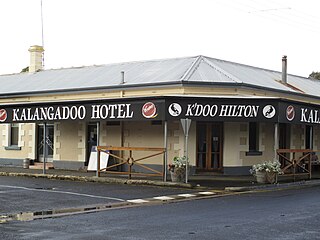
Kalangadoo, formerly Kalangadoo East, is a locality in the Australian state of South Australia located about 348 kilometres (216 mi) south-east of the state capital of Adelaide and about 31 kilometres (19 mi) north of the regional centre of Mount Gambier.

Ben Lomond is a village on the Northern Tablelands in the New England region of New South Wales, Australia. The village is situated 6 km off the New England Highway between Armidale and Glen Innes. It was located in the Guyra Shire local government area until that council was amalgamated into the Armidale Regional Council on 12 May 2016, with parts of the surrounding district in Glen Innes Severn Shire and Inverell Shire. It is primarily a farming area, with most of the residents involved in sheep, cattle and grain farming.
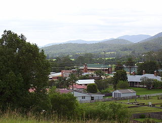
Stroud is a small country town one hour north of Newcastle, New South Wales, Australia. It is part of the Mid-Coast Council local government area. The major road through Stroud is the Bucketts Way. At the 2006 census, Stroud had a population of 669.

Wycheproof is a small town in the centre of the Shire of Buloke, in north western Victoria, Australia. As of the 2016 census, it had a population of 635.
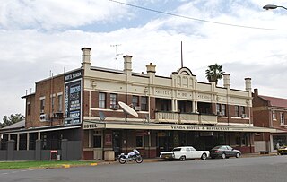
Yenda is a town in the Riverina district of New South Wales, Australia. The town is located about 16 kilometres (9.9 mi) east of Griffith, 65 kilometres (40 mi) north-west of Narrandera, and 550 kilometres (340 mi) west of Sydney in the Murrumbidgee Irrigation Area of southern New South Wales. Although most of the original 15-acre farms have been consolidated into large vineyards and most farmhouses have disappeared, farm roads are named after the original settlers. In 1940 Yenda had two clothing stores, two bakers, two butchers, two grocery stores, two barbers, one newsagency, one pharmacy, one cinema, one Greek restaurant and one bank but residents now do their shopping in nearby Griffith. At the 2011 census, Yenda had a population of 1,503.
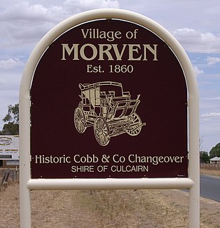
Morven is a small village about 7 kilometres east of Culcairn in the eastern Riverina district of New South Wales, Australia. At the 2006 census, Morven had a population of 464 people.
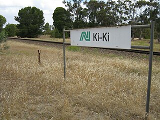
Ki Ki is a small town in South Australia. It is on the Dukes Highway (A8) adjacent to the Adelaide-Melbourne railway, the main links between Adelaide and Melbourne. The town is the primary settlement for the Hundred of Livingston.
The Temora–Roto railway line is a partly closed railway line in the southwest of New South Wales, Australia. It branches from the Lake Cargelligo line at the town of Temora and travels west through the northern part of the Riverina to the towns of Griffith and Hillston. A connection to the Broken Hill line created a cross-country route, although this was never utilised to its full potential, and the line beyond Hillston was built to low grade 'pioneer' standards.

Watheroo is a small town in the Wheatbelt region of Western Australia. There are 181 residents, according to the 2016 census.
Burrungule is a locality in South Australia.

Koolunga is a town in the Mid North of South Australia. According to the 2016 Australian Census, the population of the town and surrounding area is approximately 200.
Peebinga is a town and locality in the Australian state of South Australia. Peebinga was the terminus of the Peebinga railway line which was built in 1914 as part of a major state government project to open up the Murray Mallee for grazing and cropping.
Moolboolaman is a rural locality in the Bundaberg Region, Queensland, Australia. In the 2016 census, Moolboolaman had a population of 434 people.
