Hunter County

Last updated
Map all coordinates using: OpenStreetMap  ·  Google Maps
Download coordinates as: KML  ·  GPX
Hunter
New South Wales

Hunter NSW.PNG

Location in New South Wales
Lands administrative divisions around Hunter:
Phillip Brisbane Durham
Phillip Hunter Northumberland
Roxburgh Cook Cumberland

Hunter County was one of the original Nineteen Counties in New South Wales and is now one of the 141 Cadastral divisions of New South Wales. It lies between the Hunter River in the north, and the Colo River in the south, including much of Wollemi National Park. Macdonald River lies to the east.

Nineteen Counties area of New South Wales colony to which European settlement was legally restricted from 1826 until 1861

The Nineteen Counties were the limits of location in the colony of New South Wales, Australia. Settlers were permitted to take up land only within the counties due to the dangers in the wilderness.

New South Wales State of Australia

New South Wales is a state on the east coast of Australia. It borders Queensland to the north, Victoria to the south, and South Australia to the west. Its coast borders the Tasman Sea to the east. The Australian Capital Territory is an enclave within the state. New South Wales' state capital is Sydney, which is also Australia's most populous city. In September 2018, the population of New South Wales was over 8 million, making it Australia's most populous state. Just under two-thirds of the state's population, 5.1 million, live in the Greater Sydney area. Inhabitants of New South Wales are referred to as New South Welshmen.

Hunter River (New South Wales) river

The Hunter River is a major river in New South Wales, Australia. The Hunter River rises in the Liverpool Range and flows generally south and then east, reaching the Tasman Sea at Newcastle, the second largest city in New South Wales and a major harbour port. Its lower reaches form an open and trained mature wave dominated barrier estuary.

Hunter County was named in honour of Governor John Hunter (1737-1821). [1]

Parishes within this county

A full list of parishes found within this county; their current LGA and mapping coordinates to the approximate centre of each location is as follows:

Local government in Australia is the third tier of government in Australia administered by the states and territories, which in turn are beneath the federal tier. Local government is not mentioned in the Constitution of Australia and two referenda in the 1970s and 1980s to alter the Constitution relating to local government were unsuccessful. Every state government recognises local government in their respective constitutions. Unlike Canada or the United States, there is only one level of local government in each state, with no distinction such as cities and counties.

Parish LGA Coordinates
Angorawa City of Hawkesbury 33°18′54″S150°44′04″E / 33.31500°S 150.73444°E / -33.31500; 150.73444 (Angorawa Parish)
Arndell Muswellbrook Shire 32°21′54″S150°34′04″E / 32.36500°S 150.56778°E / -32.36500; 150.56778 (Arndell Parish)
Baerami Muswellbrook Shire 32°24′54″S150°27′04″E / 32.41500°S 150.45111°E / -32.41500; 150.45111 (Baerami Parish)
Blackwater Muswellbrook Shire 32°40′54″S150°24′04″E / 32.68167°S 150.40111°E / -32.68167; 150.40111 (Blackwater Parish)
Bulga Singleton Council 32°49′54″S150°49′04″E / 32.83167°S 150.81778°E / -32.83167; 150.81778 (Bulga Parish)
Bureen Muswellbrook Shire 32°28′54″S150°39′04″E / 32.48167°S 150.65111°E / -32.48167; 150.65111 (Bureen Parish)
Capertee City of Lithgow 33°05′54″S150°23′04″E / 33.09833°S 150.38444°E / -33.09833; 150.38444 (Capertee Parish)
Caroora Muswellbrook Shire 32°33′54″S150°25′04″E / 32.56500°S 150.41778°E / -32.56500; 150.41778 (Caroora Parish)
Colo City of Hawkesbury 33°23′24″S150°47′04″E / 33.39000°S 150.78444°E / -33.39000; 150.78444 (Colo Parish)
Cook City of Hawkesbury 33°15′54″S150°35′04″E / 33.26500°S 150.58444°E / -33.26500; 150.58444 (Cook Parish)
Coonbaralba Singleton Council 32°36′54″S150°53′04″E / 32.61500°S 150.88444°E / -32.61500; 150.88444 (Coonbaralba Parish)
Coorongooba City of Lithgow 32°57′54″S150°18′04″E / 32.96500°S 150.30111°E / -32.96500; 150.30111 (Coorongooba Parish)
Coricudgy Muswellbrook Shire 32°52′54″S150°25′04″E / 32.88167°S 150.41778°E / -32.88167; 150.41778 (Coricudgy Parish)
Doyle Singleton Council 32°35′54″S150°48′04″E / 32.59833°S 150.80111°E / -32.59833; 150.80111 (Doyle Parish)
Glen Alice City of Lithgow 33°03′54″S150°15′04″E / 33.06500°S 150.25111°E / -33.06500; 150.25111 (Glen Alice Parish)
Grono City of Hawkesbury 33°18′54″S150°49′04″E / 33.31500°S 150.81778°E / -33.31500; 150.81778 (Grono Parish)
Gullongulong Singleton Council 32°53′54″S150°41′04″E / 32.89833°S 150.68444°E / -32.89833; 150.68444 (Gullongulong Parish)
Gungalwa Muswellbrook Shire 32°32′54″S150°39′04″E / 32.54833°S 150.65111°E / -32.54833; 150.65111 (Gungalwa Parish)
Hawkesbury City of Hawkesbury 33°24′24″S150°52′04″E / 33.40667°S 150.86778°E / -33.40667; 150.86778 (Hawkesbury Parish)
Hungerford Muswellbrook Shire 32°36′54″S150°32′04″E / 32.61500°S 150.53444°E / -32.61500; 150.53444 (Hungerford Parish)
Hunter Muswellbrook Shire 32°28′54″S150°45′04″E / 32.48167°S 150.75111°E / -32.48167; 150.75111 (Hunter Parish)
Innes City of Lithgow 33°04′54″S150°29′04″E / 33.08167°S 150.48444°E / -33.08167; 150.48444 (Innes Parish)
Ivory City of Hawkesbury 33°09′54″S150°45′04″E / 33.16500°S 150.75111°E / -33.16500; 150.75111 (Ivory Parish)
Jamison City of Lithgow 32°59′54″S150°22′04″E / 32.99833°S 150.36778°E / -32.99833; 150.36778 (Jamison Parish)
Kekeelbon Singleton Council 32°48′54″S150°32′04″E / 32.81500°S 150.53444°E / -32.81500; 150.53444 (Kekeelbon Parish)
Kindarun Singleton Council 32°49′54″S150°42′04″E / 32.83167°S 150.70111°E / -32.83167; 150.70111 (Kindarun Parish)
Lemington Singleton Council 32°32′54″S151°00′04″E / 32.54833°S 151.00111°E / -32.54833; 151.00111 (Lemington Parish)
Macdonald City of Hawkesbury 33°17′54″S150°56′04″E / 33.29833°S 150.93444°E / -33.29833; 150.93444 (Macdonald Parish)
Martindale Muswellbrook Shire 32°34′54″S150°44′04″E / 32.58167°S 150.73444°E / -32.58167; 150.73444 (Martindale Parish)
McLean Singleton Council 32°58′54″S150°24′04″E / 32.98167°S 150.40111°E / -32.98167; 150.40111 (Mclean Parish)
Medhurst Singleton Council 32°45′54″S150°37′04″E / 32.76500°S 150.61778°E / -32.76500; 150.61778 (Medhurst Parish)
Mediwah Muswellbrook Shire 32°27′54″S150°32′04″E / 32.46500°S 150.53444°E / -32.46500; 150.53444 (Mediwah Parish)
Mellong City of Hawkesbury 33°15′54″S150°44′04″E / 33.26500°S 150.73444°E / -33.26500; 150.73444 (Mellong Parish)
Mirrie Muswellbrook Shire 32°36′54″S150°24′04″E / 32.61500°S 150.40111°E / -32.61500; 150.40111 (Mirrie Parish)
Monundilla Muswellbrook Shire 32°42′54″S150°31′04″E / 32.71500°S 150.51778°E / -32.71500; 150.51778 (Monundilla Parish)
Myrtle Singleton Council 32°50′54″S150°36′04″E / 32.84833°S 150.60111°E / -32.84833; 150.60111 (Myrtle Parish)
Nullo Muswellbrook Shire 32°45′54″S150°24′04″E / 32.76500°S 150.40111°E / -32.76500; 150.40111 (Nullo Parish)
Palomorang Singleton Council 32°45′54″S150°43′04″E / 32.76500°S 150.71778°E / -32.76500; 150.71778 (Palomorang Parish)
Parnell Singleton Council 32°41′54″S150°54′04″E / 32.69833°S 150.90111°E / -32.69833; 150.90111 (Parnell Parish)
Parr City of Hawkesbury 33°20′24″S150°38′04″E / 33.34000°S 150.63444°E / -33.34000; 150.63444 (Parr Parish)
Parry Singleton Council 32°59′54″S150°30′04″E / 32.99833°S 150.50111°E / -32.99833; 150.50111 (Parry Parish)
Phillip Singleton Council 32°45′54″S150°29′04″E / 32.76500°S 150.48444°E / -32.76500; 150.48444 (Phillip Parish)
Piribil Singleton Council 32°31′54″S150°50′04″E / 32.53167°S 150.83444°E / -32.53167; 150.83444 (Piribil Parish)
Poppong Singleton Council 32°44′54″S150°51′04″E / 32.74833°S 150.85111°E / -32.74833; 150.85111 (Poppong Parish)
Putty Singleton Council 32°58′54″S150°45′04″E / 32.98167°S 150.75111°E / -32.98167; 150.75111 (Putty Parish)
Six Brothers City of Hawkesbury 33°11′54″S150°37′04″E / 33.19833°S 150.61778°E / -33.19833; 150.61778 (Six Brothers Parish)
Sturt Singleton Council 32°52′54″S150°30′04″E / 32.88167°S 150.50111°E / -32.88167; 150.50111 (Sturt Parish)
Tollagong Singleton Council 32°55′54″S150°37′04″E / 32.93167°S 150.61778°E / -32.93167; 150.61778 (Tollagong Parish)
Tomalpin Muswellbrook Shire 32°32′54″S150°33′04″E / 32.54833°S 150.55111°E / -32.54833; 150.55111 (Tomalpin Parish)
Tonga Singleton Council 32°40′54″S150°45′04″E / 32.68167°S 150.75111°E / -32.68167; 150.75111 (Tonga Parish)
Tupa Singleton Council 33°00′54″S150°37′04″E / 33.01500°S 150.61778°E / -33.01500; 150.61778 (Tupa Parish)
Wambo Singleton Council 32°31′54″S150°55′04″E / 32.53167°S 150.91778°E / -32.53167; 150.91778 (Wambo Parish)
Wareng Singleton Council 32°50′54″S150°47′04″E / 32.84833°S 150.78444°E / -32.84833; 150.78444 (Wareng Parish)
Weeney City of Hawkesbury 33°03′54″S150°46′04″E / 33.06500°S 150.76778°E / -33.06500; 150.76778 (Weeney Parish)
White Muswellbrook Shire 32°39′54″S150°38′04″E / 32.66500°S 150.63444°E / -32.66500; 150.63444 (White Parish)
Whybrow Singleton Council 32°37′54″S151°00′04″E / 32.63167°S 151.00111°E / -32.63167; 151.00111 (Whybrow Parish)
Wilpen Muswellbrook Shire 32°28′54″S150°26′04″E / 32.48167°S 150.43444°E / -32.48167; 150.43444 (Wilpen Parish)
Windsor City of Hawkesbury 33°10′54″S150°49′04″E / 33.18167°S 150.81778°E / -33.18167; 150.81778 (Windsor Parish)
Wirraba City of Hawkesbury 33°06′54″S150°33′04″E / 33.11500°S 150.55111°E / -33.11500; 150.55111 (Wirraba Parish)
Wolgan City of Lithgow 33°09′54″S150°30′04″E / 33.16500°S 150.50111°E / -33.16500; 150.50111 (Wolgan Parish)
Wollemi City of Hawkesbury 33°06′54″S150°39′04″E / 33.11500°S 150.65111°E / -33.11500; 150.65111 (Wollemi Parish)
Womerah City of Hawkesbury 33°14′54″S150°53′04″E / 33.24833°S 150.88444°E / -33.24833; 150.88444 (Womerah Parish)
Wonga City of Hawkesbury 33°22′24″S150°54′04″E / 33.37333°S 150.90111°E / -33.37333; 150.90111 (Wonga Parish)
Yengo City of Hawkesbury 33°02′54″S150°49′04″E / 33.04833°S 150.81778°E / -33.04833; 150.81778 (Yengo Parish)

Related Research Articles

Goulburn River (New South Wales) river in New South Wales, Australia

Goulburn River, a perennial river of the Hunter River catchment, is located in the Upper Hunter region of New South Wales, Australia.

Woodberry, New South Wales Suburb of Maitland, New South Wales, Australia

Woodberry is one of the eastern-most suburbs of the City of Maitland in the Hunter Region of New South Wales, Australia. At the 2011 census, Woodberry's population was 3,155. Most of the population lives in residential subdivisions while almost 84% of the suburbs land is rural in nature. Rental accommodation is occupied by 33.33% of the residents.

Durham County, New South Wales Cadastral in New South Wales, Australia

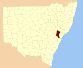
Durham County was one of the original Nineteen Counties in New South Wales and is now one of the 141 Cadastral divisions of New South Wales. It is bordered on the south and west by the Hunter River, and on the north and east by the Williams River. It includes Aberdeen and Muswellbrook. Before 1834, the area known as Durham County included what later became Gloucester and most of Brisbane counties, as far west as the Liverpool Range, and east to the Pacific, including Port Stephens, as shown on an 1832 map.

Northumberland County, New South Wales Cadastral in New South Wales, Australia

Northumberland County was one of the original Nineteen Counties in New South Wales and is now one of the 141 Cadastral divisions of New South Wales. It included the area to the north of Broken Bay, including Lake Macquarie and Newcastle. It was bounded by the part of the Hawkesbury River to the south, the Macdonald River to the south-west, and the Hunter River to the north.

Brisbane County Cadastral in New South Wales, Australia

Brisbane County was one of the original Nineteen Counties in New South Wales and is now one of the 141 Cadastral divisions of New South Wales. It includes Scone, Merriwa and Murrurundi. The Goulburn River is the boundary to the south and the Hunter River the boundary to the south-east. The Liverpool Range area is the boundary to the north, and the Krui River the boundary to the west.

Bow River, a partly perennial stream of the Hunter River catchment, is located in the Hunter district of New South Wales, Australia.

Chichester River river in Australia

The Chichester River, a perennial stream of the Hunter River catchment, is located in the Hunter region of New South Wales, Australia.

Isis River, a perennial river of the Hunter River catchment, is located in the Upper Hunter region of New South Wales, Australia.

Krui River, a perennial river of the Hunter River catchment, is located in the Upper Hunter region of New South Wales, Australia.

Munmurra River, a perennial river of the Hunter River catchment, is located in the Upper Hunter region of New South Wales, Australia.

Pages River river in Australia

Pages River, a perennial river of the Hunter River catchment, is located in the Hunter region of New South Wales, Australia.

Wangat River, a perennial river of the Hunter River catchment, is located in the Hunter region of New South Wales, Australia.

Williams River (New South Wales) river in New South Wales, Australia

The Williams River is a perennial stream that is a tributary of the Hunter River, in the Hunter Region of New South Wales, Australia.

Worondi Rivulet, a perennial stream of the Hunter River catchment, is located in the Upper Hunter region of New South Wales, Australia.

Cooba Bulga Stream, a mostly perennial stream of the Hunter River catchment, is located in the Hunter region of New South Wales, Australia.

Pages Creek, a mostly perennial stream of the Hunter River catchment, is located in the Hunter region of New South Wales, Australia.

Moonan Brook, a mostly perennial stream of the Hunter River catchment, is located in the Hunter region of New South Wales, Australia.

Rouchel Brook, a perennial stream of the Hunter River catchment, is located in the Hunter region of New South Wales, Australia.

Stewarts Brook, a perennial stream of the Hunter River catchment, is located in the Hunter region of New South Wales, Australia.

References

  1. "Hunter County". Geographical Names Register (GNR) of NSW. Geographical Names Board of New South Wales.