Durham County, New South Wales

Last updated

Map all coordinates using: OpenStreetMap  
Download coordinates as: KML  ·  GPX
Durham
New South Wales
Durham NSW.PNG
Location in New South Wales
Lands administrative divisions around Durham:
Brisbane Hawes Gloucester
Brisbane Durham Gloucester
Hunter Northumberland Gloucester

Durham County was one of the original Nineteen Counties in New South Wales and is now one of the 141 Cadastral divisions of New South Wales. It is bordered on the south and west by the Hunter River, and on the north and east by the Williams River. It includes Aberdeen and Muswellbrook. Before 1834, the area known as Durham County included what later became Gloucester and most of Brisbane counties, as far west as the Liverpool Range, and east to the Pacific, including Port Stephens, as shown on an 1832 map.

Nineteen Counties area of New South Wales colony to which European settlement was legally restricted from 1826 until 1861

The Nineteen Counties were the limits of location in the colony of New South Wales, Australia. Settlers were permitted to take up land only within the counties due to the dangers in the wilderness.

New South Wales State of Australia

New South Wales is a state on the east coast of Australia. It borders Queensland to the north, Victoria to the south, and South Australia to the west. Its coast borders the Tasman Sea to the east. The Australian Capital Territory is an enclave within the state. New South Wales' state capital is Sydney, which is also Australia's most populous city. In December 2018, the population of New South Wales was over 8 million, making it Australia's most populous state. Just under two-thirds of the state's population, 5.1 million, live in the Greater Sydney area. Inhabitants of New South Wales are referred to as New South Welshmen.

Hunter River (New South Wales) river

The Hunter River is a major river in New South Wales, Australia. The Hunter River rises in the Liverpool Range and flows generally south and then east, reaching the Tasman Sea at Newcastle, the second largest city in New South Wales and a major harbour port. Its lower reaches form an open and trained mature wave dominated barrier estuary.

Contents

Durham County was named in honour of John George Lambton, First Earl of Durham (1792-1840). [1]

Parishes within this county

A full list of parishes found within this county; their current LGA and mapping coordinates to the approximate centre of each location is as follows:

Local government in Australia

Local government in Australia is the third tier of government in Australia administered by the states and territories, which in turn are beneath the federal tier. Local government is not mentioned in the Constitution of Australia and two referenda in the 1970s and 1980s to alter the Constitution relating to local government were unsuccessful. Every state government recognises local government in their respective constitutions. Unlike Canada or the United States, there is only one level of local government in each state, with no distinction such as cities and counties.

ParishLGACoordinates
Allyn Dungog Shire 32°07′54″S151°28′04″E / 32.13167°S 151.46778°E / -32.13167; 151.46778 (Allyn Parish)
Althorpe Muswellbrook Shire 32°24′54″S150°46′04″E / 32.41500°S 150.76778°E / -32.41500; 150.76778 (Althorpe Parish)
Auckland Singleton Council 32°30′54″S151°06′04″E / 32.51500°S 151.10111°E / -32.51500; 151.10111 (Auckland Parish)
Avenal Dungog Shire 32°18′54″S151°34′04″E / 32.31500°S 151.56778°E / -32.31500; 151.56778 (Avenal Parish)
Balmoral Muswellbrook Shire 32°14′54″S150°59′04″E / 32.24833°S 150.98444°E / -32.24833; 150.98444 (Balmoral Parish)
Barford Dungog Shire 32°32′54″S151°38′04″E / 32.54833°S 151.63444°E / -32.54833; 151.63444 (Barford Parish)
Belltrees Upper Hunter Shire 31°58′54″S151°10′04″E / 31.98167°S 151.16778°E / -31.98167; 151.16778 (Belltrees Parish)
Boonabilla Dungog Shire 32°07′54″S151°22′04″E / 32.13167°S 151.36778°E / -32.13167; 151.36778 (Boonabilla Parish)
Bronte Upper Hunter Shire 31°53′54″S151°24′04″E / 31.89833°S 151.40111°E / -31.89833; 151.40111 (Bronte Parish)
Brougham Muswellbrook Shire 32°18′54″S150°53′04″E / 32.31500°S 150.88444°E / -32.31500; 150.88444 (Brougham Parish)
Butterwick Port Stephens Council 32°39′54″S151°38′04″E / 32.66500°S 151.63444°E / -32.66500; 151.63444 (Butterwick Parish)
Carrow Dungog Shire 32°14′54″S151°21′04″E / 32.24833°S 151.35111°E / -32.24833; 151.35111 (Carrow Parish)
Chalmers Upper Hunter Shire 32°02′54″S151°13′04″E / 32.04833°S 151.21778°E / -32.04833; 151.21778 (Chalmers Parish)
Colonna Dungog Shire 32°14′54″S151°31′04″E / 32.24833°S 151.51778°E / -32.24833; 151.51778 (Colonna Parish)
Darlington Singleton Council 32°30′54″S151°11′04″E / 32.51500°S 151.18444°E / -32.51500; 151.18444 (Darlington Parish)
Doon Upper Hunter Shire 32°05′54″S151°15′04″E / 32.09833°S 151.25111°E / -32.09833; 151.25111 (Doon Parish)
Dungog Dungog Shire 32°25′54″S151°43′04″E / 32.43167°S 151.71778°E / -32.43167; 151.71778 (Dungog Parish)
Dyrring Singleton Council 32°25′54″S151°17′04″E / 32.43167°S 151.28444°E / -32.43167; 151.28444 (Dyrring Parish)
Fingal Dungog Shire 32°27′54″S151°36′04″E / 32.46500°S 151.60111°E / -32.46500; 151.60111 (Fingal Parish)
Foy Muswellbrook Shire 32°13′54″S151°09′04″E / 32.23167°S 151.15111°E / -32.23167; 151.15111 (Foy Parish)
Glendon Dungog Shire 32°21′54″S151°22′04″E / 32.36500°S 151.36778°E / -32.36500; 151.36778 (Glendon Parish)
Goorangoola Singleton Council 32°23′54″S151°08′04″E / 32.39833°S 151.13444°E / -32.39833; 151.13444 (Goorangoola Parish)
Gotha Singleton Council 32°18′54″S151°17′04″E / 32.31500°S 151.28444°E / -32.31500; 151.28444 (Gotha Parish)
Gresford Dungog Shire 32°29′54″S151°32′04″E / 32.49833°S 151.53444°E / -32.49833; 151.53444 (Gresford Parish)
Herschell Muswellbrook Shire 32°13′54″S151°05′04″E / 32.23167°S 151.08444°E / -32.23167; 151.08444 (Herschell Parish)
Holywell Dungog Shire 32°19′54″S151°30′04″E / 32.33167°S 151.50111°E / -32.33167; 151.50111 (Holywell Parish)
Houghton Dungog Shire 32°36′0″S151°33′57″E / 32.60000°S 151.56583°E / -32.60000; 151.56583 (Houghton Parish)
Howick Singleton Council 32°27′54″S150°56′04″E / 32.46500°S 150.93444°E / -32.46500; 150.93444 (Howick Parish)
Lewinsbrook Dungog Shire 32°22′54″S151°33′04″E / 32.38167°S 151.55111°E / -32.38167; 151.55111 (Lewinsbrook Parish)
Liddell Muswellbrook Shire 32°21′54″S151°00′04″E / 32.36500°S 151.00111°E / -32.36500; 151.00111 (Liddell Parish)
Liebeg Singleton Council 32°14′54″S151°15′04″E / 32.24833°S 151.25111°E / -32.24833; 151.25111 (Liebeg Parish)
Mamaran Upper Hunter Shire 31°47′54″S151°24′04″E / 31.79833°S 151.40111°E / -31.79833; 151.40111 (Mamaran Parish)
Marwood Singleton Council 32°33′54″S151°21′04″E / 32.56500°S 151.35111°E / -32.56500; 151.35111 (Marwood Parish)
Middlehope Dungog Shire 32°39′54″S151°38′04″E / 32.66500°S 151.63444°E / -32.66500; 151.63444 (Middlehope Parish)
Mirannie Singleton Council 32°27′54″S151°20′04″E / 32.46500°S 151.33444°E / -32.46500; 151.33444 (Mirannie Parish)
Moonan Upper Hunter Shire 31°56′54″S151°14′04″E / 31.94833°S 151.23444°E / -31.94833; 151.23444 (Moonan Parish)
Mount Royal Singleton Council 32°10′54″S151°18′04″E / 32.18167°S 151.30111°E / -32.18167; 151.30111 (Mount Royal Parish)
Oldcastle Upper Hunter Shire 32°00′54″S151°19′04″E / 32.01500°S 151.31778°E / -32.01500; 151.31778 (Oldcastle Parish)
Omadale Upper Hunter Shire 31°51′54″S151°20′04″E / 31.86500°S 151.33444°E / -31.86500; 151.33444 (Omadale Parish)
Prospero Upper Hunter Shire 31°59′54″S151°22′04″E / 31.99833°S 151.36778°E / -31.99833; 151.36778 (Prospero Parish)
Ravensworth Singleton Council 32°29′54″S151°00′04″E / 32.49833°S 151.00111°E / -32.49833; 151.00111 (Ravensworth Parish)
Rosamond Singleton Council 32°09′54″S151°15′04″E / 32.16500°S 151.25111°E / -32.16500; 151.25111 (Rosamond Parish)
Rouchel Upper Hunter Shire 32°07′54″S151°00′04″E / 32.13167°S 151.00111°E / -32.13167; 151.00111 (Rouchel Parish)
Rowan Muswellbrook Shire 32°13′54″S150°57′04″E / 32.23167°S 150.95111°E / -32.23167; 150.95111 (Rowan Parish)
Russell Upper Hunter Shire 32°09′54″S150°57′04″E / 32.16500°S 150.95111°E / -32.16500; 150.95111 (Russell Parish)
Savoy Muswellbrook Shire 32°20′54″S150°57′04″E / 32.34833°S 150.95111°E / -32.34833; 150.95111 (Savoy Parish)
Seaham Port Stephens Council 32°39′25″S151°41′57″E / 32.65694°S 151.69917°E / -32.65694; 151.69917 (Seaham Parish)
Sedgefield Singleton Council 32°31′54″S151°15′04″E / 32.53167°S 151.25111°E / -32.53167; 151.25111 (Sedgefield Parish)
Shenstone Singleton Council 32°23′54″S151°12′04″E / 32.39833°S 151.20111°E / -32.39833; 151.20111 (Shenstone Parish)
St Aubins Upper Hunter Shire 32°10′54″S151°00′04″E / 32.18167°S 151.00111°E / -32.18167; 151.00111 (St Aubins Parish)
St Julian Dungog Shire 32°22′54″S151°28′04″E / 32.38167°S 151.46778°E / -32.38167; 151.46778 (St Julian Parish)
Stanhope Singleton Council 32°33′54″S151°25′04″E / 32.56500°S 151.41778°E / -32.56500; 151.41778 (Stanhope Parish)
Tangory Singleton Council 32°28′54″S151°24′04″E / 32.48167°S 151.40111°E / -32.48167; 151.40111 (Tangory Parish)
Tillegra Dungog Shire 32°20′54″S151°42′04″E / 32.34833°S 151.70111°E / -32.34833; 151.70111 (Tillegra Parish)
Tudor Upper Hunter Shire 32°10′54″S151°08′04″E / 32.18167°S 151.13444°E / -32.18167; 151.13444 (Tudor Parish)
Tyraman Dungog Shire 32°29′54″S151°30′04″E / 32.49833°S 151.50111°E / -32.49833; 151.50111 (Tyraman Parish)
Uffington Dungog Shire, Port Stephens Council 32°35′54″S151°44′04″E / 32.59833°S 151.73444°E / -32.59833; 151.73444 (Uffington Parish)
Underbank Dungog Shire 32°14′54″S151°33′04″E / 32.24833°S 151.55111°E / -32.24833; 151.55111 (Underbank Parish)
Vane Singleton Council 32°26′54″S151°07′04″E / 32.44833°S 151.11778°E / -32.44833; 151.11778 (Vane Parish)
Vaux Muswellbrook Shire 32°20′54″S150°47′04″E / 32.34833°S 150.78444°E / -32.34833; 150.78444 (Vaux Parish)
Wallarobba Dungog Shire 32°28′54″S151°43′04″E / 32.48167°S 151.71778°E / -32.48167; 151.71778 (Wallarobba Parish)
Wolfingham Dungog Shire 32°37′54″S151°29′04″E / 32.63167°S 151.48444°E / -32.63167; 151.48444 (Wolfingham Parish)
Wynn Muswellbrook Shire 32°21′54″S150°52′04″E / 32.36500°S 150.86778°E / -32.36500; 150.86778 (Wynn Parish)

Related Research Articles

County Durham County of England

County Durham is a county in North East England. The county town is Durham, a cathedral city. The largest settlement is Darlington, closely followed by Hartlepool and Stockton-on-Tees. It borders Tyne and Wear to the north east, Northumberland to the north, Cumbria to the west and North Yorkshire to the south. The county's historic boundaries stretch between the rivers Tyne and Tees, thus including places such as Gateshead, Jarrow, South Shields and Sunderland.

Lands administrative divisions of New South Wales Wikimedia list article

The lands administrative divisions of New South Wales refers to the 141 counties within the Colony of New South Wales, that later became the Australian state of New South Wales.

Cook County, New South Wales Cadastral in New South Wales, Australia

Cook County was one of the original Nineteen Counties in New South Wales and is now one of the 141 Cadastral divisions of New South Wales. It includes the area to the west of Sydney in the Blue Mountains, between the Colo River in the north, and the Coxs River in the south and west, encompassing Lithgow, Mount Victoria, Katoomba, Wentworth Falls, Lawson and most of the other towns in the Blue Mountains. The Nepean River is the border to the east. Before 1834, the area was part of the Westmoreland, Northumberland and Roxburgh counties.

Westmoreland County, New South Wales Cadastral in New South Wales, Australia

Westmoreland County was one of the original Nineteen Counties in New South Wales and is now one of the 141 Cadastral divisions of New South Wales. It is to the west of Sydney in the Blue Mountains. Coxs River is the border to the north, and the Wollondilly River to the east. Campbells River is the border in the north-east, where the county extends to near Bathurst, with the Fish River part of the border. It includes the town of Oberon, and the Kanangra-Boyd National Park.

Brisbane County Cadastral in New South Wales, Australia

Brisbane County was one of the original Nineteen Counties in New South Wales and is now one of the 141 Cadastral divisions of New South Wales. It includes Scone, Merriwa and Murrurundi. The Goulburn River is the boundary to the south and the Hunter River the boundary to the south-east. The Liverpool Range area is the boundary to the north, and the Krui River the boundary to the west.

Phillip County Cadastral in New South Wales, Australia

Phillip County was one of the original Nineteen Counties in New South Wales and is now one of the 141 Cadastral divisions of New South Wales. It includes the area to the east of Mudgee and Gulgong. The Cudgegong River is the border to the south-west, and the Goulburn River the border to the north.

Barrona County Cadastral in New South Wales, Australia

Barrona County is one of the 141 Cadastral divisions of New South Wales. It is bounded by the Warrego River in the east and the Paroo River in the west.

Ewenmar County Cadastral in New South Wales, Australia

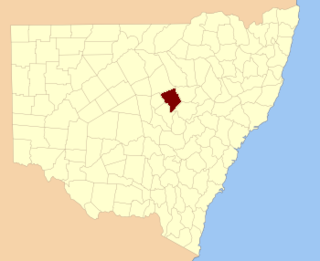
Ewenmar County is one of the 141 Cadastral divisions of New South Wales. It is located between the Macquarie River on the west, and the Castlereagh River on the east. This is the area between Warren and Gilgandra.

Irrara County Cadastral in New South Wales, Australia

Irrara County is one of the 141 Cadastral divisions of New South Wales. It is located south of the border with Queensland, east of the Paroo River, and west of the Warrego River.

Narromine County Cadastral in New South Wales, Australia

Narromine County is one of the 141 Cadastral divisions of New South Wales. It is located between the Bogan River on the west and the Macquarie River on the east, in the area around Narromine.

Oxley County Cadastral in New South Wales, Australia

Oxley County, New South Wales is one of the 141 Cadastral divisions of New South Wales. It is located between the Bogan River on the west, and the Macquarie River on the east. This is the area approximately between Warren and Nyngan.

The East Branch South Fork Eel River, a tributary of the South Fork Eel River, is formed by the confluence of Cruso Cabin Creek and Elkhorn Creek, in Mendocino County in the U.S. state of California. The river is roughly 25 miles (40 km) long, meandering west to its confluence with the South Fork Eel at Benbow Lake State Recreation Area. Major tributaries of the East Branch include Buck Mountain Creek, Squaw Creek, Rays Creek, and Tom Long Creek. The river flows west, turns north, and flows west again, through rugged terrain in the Coast Range of California. The East Branch is the South Fork Eel's largest tributary.

Boyd River, a perennial stream that is part of the Clarence River catchment, is located in the Northern Tablelands district of New South Wales, Australia.

Cobrabald River

Cobrabald River, a mostly perennial river that is part of the Namoi catchment within the Murray–Darling basin, is located in the Northern Tablelands district of New South Wales, Australia.

The Coolumbooka River, a perennial river of the Snowy River catchment, is located in the Monaro region of New South Wales, Australia.

Crookwell River

The Crookwell River is a perennial river that is part of the Lachlan catchment within the Murray–Darling basin, located in the Southern Tablelands and South West Slopes regions of New South Wales, Australia.

The Jooriland River, a perennial river that is part of the Hawkesbury-Nepean catchment, is located in the Central Tablelands and Macarthur regions of New South Wales, Australia.

The Nullica River is an intermittently closed semi-mature saline coastal lagoon or perennial river, located in the South Coast region of New South Wales, Australia.

Worondi Rivulet, a perennial stream of the Hunter River catchment, is located in the Upper Hunter region of New South Wales, Australia.

Jerrabattgulla Creek, a perennial stream of the Shoalhaven River catchment, is located in the Southern Tablelands region of New South Wales, Australia.

References

  1. "Durham". Geographical Names Register (GNR) of NSW. Geographical Names Board of New South Wales . Retrieved 5 August 2013. OOjs UI icon edit-ltr-progressive.svg