Beresford County

Last updated

Map all coordinates using: OpenStreetMap  
Download coordinates as: KML  ·  GPX
Beresford
New South Wales
Beresford NSW.PNG
Location in New South Wales
Lands administrative divisions around Beresford:
Cowley Murray Murray
Wallace Beresford Dampier
Wallace Wellesley Auckland

Beresford County is one of the 141 Cadastral divisions of New South Wales. It contains Cooma and Bredbo. Part of the Murrumbidgee River forms the boundary in the north-west, and a separate part of the river forms part of the western boundary.

Beresford County was named in honour of Viscount William Carr Beresford (1768-1854). [1]

Parishes within this county

A full list of parishes found within this county; their current LGA and mapping coordinates to the approximate centre of each location is as follows:

ParishLGACoordinates
Abercrombie Snowy Monaro Regional Council 36°01′54″S149°15′04″E / 36.03167°S 149.25111°E / -36.03167; 149.25111 (Abercrombie Parish)
Big Badja Snowy Monaro Regional Council 36°02′54″S149°32′04″E / 36.04833°S 149.53444°E / -36.04833; 149.53444 (Big Badja Parish)
Billilingra Snowy Monaro Regional Council 36°00′54″S149°09′04″E / 36.01500°S 149.15111°E / -36.01500; 149.15111 (Billilingra Parish)
Binjura Snowy Monaro Regional Council 36°11′54″S149°06′04″E / 36.19833°S 149.10111°E / -36.19833; 149.10111 (Binjura Parish)
Bransby Snowy Monaro Regional Council 35°55′54″S149°09′04″E / 35.93167°S 149.15111°E / -35.93167; 149.15111 (Bransby Parish)
Bredbo Snowy Monaro Regional Council 35°59′54″S149°00′04″E / 35.99833°S 149.00111°E / -35.99833; 149.00111 (Bredbo Parish)
Brest Snowy Monaro Regional Council 35°57′54″S148°56′04″E / 35.96500°S 148.93444°E / -35.96500; 148.93444 (Brest Parish)
Bulgundramine Snowy Monaro Regional Council 36°25′54″S149°16′04″E / 36.43167°S 149.26778°E / -36.43167; 149.26778 (Bulgundramine Parish)
Bullanamang Snowy Monaro Regional Council 35°56′54″S149°05′04″E / 35.94833°S 149.08444°E / -35.94833; 149.08444 (Bullanamang Parish)
Bunyan Snowy Monaro Regional Council 36°16′54″S149°11′04″E / 36.28167°S 149.18444°E / -36.28167; 149.18444 (Bunyan Parish)
Callaghan Snowy Monaro Regional Council 36°03′54″S149°12′04″E / 36.06500°S 149.20111°E / -36.06500; 149.20111 (Callaghan Parish)
Clifford Snowy Monaro Regional Council 36°05′54″S149°14′04″E / 36.09833°S 149.23444°E / -36.09833; 149.23444 (Clifford Parish)
Colinton Snowy Monaro Regional Council 35°50′54″S149°12′04″E / 35.84833°S 149.20111°E / -35.84833; 149.20111 (Colinton Parish)
Coolringdon Snowy Monaro Regional Council 36°13′54″S148°58′04″E / 36.23167°S 148.96778°E / -36.23167; 148.96778 (Coolringdon Parish)
Cooma Snowy Monaro Regional Council 36°14′54″S149°07′04″E / 36.24833°S 149.11778°E / -36.24833; 149.11778 (Cooma Parish)
Cosgrove Snowy Monaro Regional Council 35°59′54″S149°00′04″E / 35.99833°S 149.00111°E / -35.99833; 149.00111 (Cosgrove Parish)
Dangelong Snowy Monaro Regional Council 36°17′54″S149°16′04″E / 36.29833°S 149.26778°E / -36.29833; 149.26778 (Dangelong Parish)
Duncan Snowy Monaro Regional Council 35°54′54″S148°50′04″E / 35.91500°S 148.83444°E / -35.91500; 148.83444 (Duncan Parish)
Flinders Snowy Monaro Regional Council 35°56′54″S149°00′04″E / 35.94833°S 149.00111°E / -35.94833; 149.00111 (Flinders Parish)
Gladstone Snowy Monaro Regional Council 36°19′54″S149°10′04″E / 36.33167°S 149.16778°E / -36.33167; 149.16778 (Gladstone Parish)
Good Good Snowy Monaro Regional Council 36°02′54″S149°27′04″E / 36.04833°S 149.45111°E / -36.04833; 149.45111 (Good Good Parish)
Gungoandra Snowy Monaro Regional Council 35°53′54″S149°11′04″E / 35.89833°S 149.18444°E / -35.89833; 149.18444 (Gungoandra Parish)
Hill Snowy Monaro Regional Council 35°55′54″S149°28′04″E / 35.93167°S 149.46778°E / -35.93167; 149.46778 (Hill Parish)
Holland Snowy Monaro Regional Council 35°46′54″S149°22′04″E / 35.78167°S 149.36778°E / -35.78167; 149.36778 (Holland Parish)
Jillimatong Snowy Monaro Regional Council 36°17′54″S148°59′04″E / 36.29833°S 148.98444°E / -36.29833; 148.98444 (Jillimatong Parish)
Kybeyan Snowy Monaro Regional Council 36°22′54″S149°27′04″E / 36.38167°S 149.45111°E / -36.38167; 149.45111 (Kybeyan Parish)
Kydra Snowy Monaro Regional Council 36°27′54″S149°25′04″E / 36.46500°S 149.41778°E / -36.46500; 149.41778 (Kydra Parish)
Lucas Snowy Monaro Regional Council 36°15′54″S149°24′04″E / 36.26500°S 149.40111°E / -36.26500; 149.40111 (Lucas Parish)
Michelago Snowy Monaro Regional Council 35°47′54″S149°10′04″E / 35.79833°S 149.16778°E / -35.79833; 149.16778 (Michelago Parish)
Milford Snowy Monaro Regional Council 35°49′54″S149°22′04″E / 35.83167°S 149.36778°E / -35.83167; 149.36778 (Milford Parish)
Montagu Snowy Monaro Regional Council 36°15′54″S149°16′04″E / 36.26500°S 149.26778°E / -36.26500; 149.26778 (Montagu Parish)
Murrumbucca Snowy Monaro Regional Council 36°03′54″S148°59′04″E / 36.06500°S 148.98444°E / -36.06500; 148.98444 (Murrumbucca Parish)
Numeralla Snowy Monaro Regional Council 36°10′54″S149°16′04″E / 36.18167°S 149.26778°E / -36.18167; 149.26778 (Numeralla Parish)
Onslow Snowy Monaro Regional Council 35°48′54″S149°17′04″E / 35.81500°S 149.28444°E / -35.81500; 149.28444 (Onslow Parish)
Palmerston Snowy Monaro Regional Council 36°22′54″S149°27′04″E / 36.38167°S 149.45111°E / -36.38167; 149.45111 (Palmerston Parish)
Rivers Snowy Monaro Regional Council 36°17′54″S149°21′04″E / 36.29833°S 149.35111°E / -36.29833; 149.35111 (Rivers Parish)
Rose Valley Snowy Monaro Regional Council 36°07′54″S149°23′04″E / 36.13167°S 149.38444°E / -36.13167; 149.38444 (Rose Valley Parish)
Rowland Snowy Monaro Regional Council 35°55′54″S149°23′04″E / 35.93167°S 149.38444°E / -35.93167; 149.38444 (Rowland Parish)
Sherlock Snowy Monaro Regional Council 35°49′54″S149°27′04″E / 35.83167°S 149.45111°E / -35.83167; 149.45111 (Sherlock Parish)
Stannard Snowy Monaro Regional Council 36°00′54″S149°21′04″E / 36.01500°S 149.35111°E / -36.01500; 149.35111 (Stannard Parish)
The Brothers Snowy Monaro Regional Council 36°19′54″S149°07′04″E / 36.33167°S 149.11778°E / -36.33167; 149.11778 (The Brothers Parish)
Throsby Snowy Monaro Regional Council 36°23′54″S149°21′04″E / 36.39833°S 149.35111°E / -36.39833; 149.35111 (Throsby Parish)
Tinderry Snowy Monaro Regional Council 35°45′54″S149°15′04″E / 35.76500°S 149.25111°E / -35.76500; 149.25111 (Tinderry Parish)
Undoo Snowy Monaro Regional Council 36°09′54″S149°28′04″E / 36.16500°S 149.46778°E / -36.16500; 149.46778 (Undoo Parish)
Wangrah Snowy Monaro Regional Council 35°52′54″S149°19′04″E / 35.88167°S 149.31778°E / -35.88167; 149.31778 (Wangrah Parish)
Winifred Snowy Monaro Regional Council 36°30′54″S149°24′04″E / 36.51500°S 149.40111°E / -36.51500; 149.40111 (Winifred Parish)
Wise Snowy Monaro Regional Council 35°40′54″S149°20′04″E / 35.68167°S 149.33444°E / -35.68167; 149.33444 (Wise Parish)
Woolumla Snowy Monaro Regional Council 36°05′54″S149°09′04″E / 36.09833°S 149.15111°E / -36.09833; 149.15111 (Woolumla Parish)
York Snowy Monaro Regional Council 36°02′10″S149°05′29″E / 36.03611°S 149.09139°E / -36.03611; 149.09139 (York Parish)

Related Research Articles

Historic counties of England Geographical designations for areas of England, based on historical traditions

The historic counties of England are areas that were established for administration by the Normans, in many cases based on earlier kingdoms and shires created by the Anglo-Saxons and others. They are alternatively known as ancient counties, traditional counties, former counties or simply as counties. In the centuries that followed their establishment, as well as their administrative function, the counties also helped define local culture and identity. This role continued even after the counties ceased to be used for administration after the creation of administrative counties in 1889, which were themselves amended by further local government reforms in the years following.

Macintyre River

The Macintyre River, a perennial river that forms part of the Border Rivers group, is part of the Barwon catchment of the Murray-Darling basin, located in the Northern Tablelands and North West Slopes regions of New South Wales, and the Southern Downs region of Queensland, Australia.

William Beresford, 1st Viscount Beresford

General William Carr Beresford, 1st Viscount Beresford, 1st Marquis of Campo Maior, was an Anglo-Irish soldier and politician. A general in the British Army and a Marshal in the Portuguese Army, he fought alongside The Duke of Wellington in the Peninsular War and held the office of Master-General of the Ordnance in 1828 in Wellington's first ministry.

South Creek (New South Wales)

The South Creek or Wianamatta, a creek that is part of the Hawkesbury-Nepean catchment, is located on the Cumberland Plain, also referred to as Greater Western Sydney, New South Wales, Australia.

Dumaresq River

The Dumaresq River ; a perennial stream of the Macintyre catchment within the Murray–Darling basin, is located in the Northern Tablelands and North West Slopes regions of New South Wales and the Darling Downs region of Queensland, Australia.

Halls Stream

Halls Stream or Rivière Hall is a 25.2-mile-long (40.6 km) tributary of the Connecticut River in eastern North America. For most of its length, it forms the Canada–United States border, with the province of Quebec (Canada) to its west and the state of New Hampshire to its east.

Georgiana County Cadastral in New South Wales, Australia

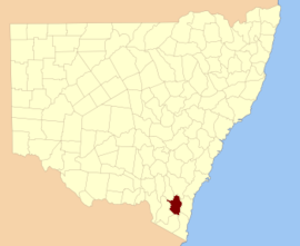
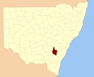
Georgiana County was one of the original Nineteen Counties in New South Wales and is now one of the 141 Cadastral divisions of New South Wales. It lies in the area about halfway between Bathurst and Goulburn. The Lachlan River is the western boundary, with the Crookwell River the southern boundary. It includes Bigga, and the area surrounding the Abercrombie River. It was part of the Electoral district of King and Georgiana from 1856 to 1859.

King County, New South Wales Cadastral in New South Wales, Australia

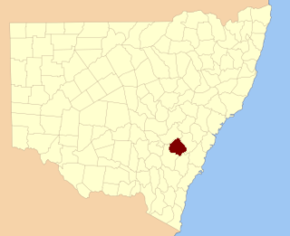
King County was one of the original Nineteen Counties in New South Wales and is now one of the 141 cadastral divisions of New South Wales. It is in the area to the east of Yass. The northern part of it lies between the Lachlan River and the Boorowa River, including the locations of Frogmore, Taylors Flat, Gunnary, Rugby and Rye Park. The Crookwell River is also part of the northern boundary. The Yass River is the southern boundary.

Bathurst County Cadastral in New South Wales, Australia

Bathurst County was one of the original Nineteen Counties in New South Wales and is now one of the 141 Cadastral divisions of New South Wales. It includes the area to the south-west of Bathurst to Cowra and Orange. The Lachlan River is the boundary to the south-west, the Belubula River forms part of the northern boundary, with the Fish River on the northeastern boundary. Blayney is located roughly in the middle.

Brisbane County Cadastral in New South Wales, Australia

Brisbane County was one of the original Nineteen Counties in New South Wales and is now one of the 141 Cadastral divisions of New South Wales. It includes Scone, Merriwa and Murrurundi. The Goulburn River is the boundary to the south and the Hunter River the boundary to the south-east. The Liverpool Range area is the boundary to the north, and the Krui River the boundary to the west.

Bligh County Cadastral in New South Wales, Australia

Bligh County was one of the original Nineteen Counties in New South Wales and is now one of the 141 Cadastral divisions of New South Wales. The Cudgegong River and the Goulburn River are its southern boundaries; the Krui River is the eastern boundary, and the Burragundy River the northern boundary. It includes the villages of Cassilis and Dunedoo.

Buccleuch County Cadastral in New South Wales, Australia

Buccleuch County is one of the 141 Cadastral divisions of New South Wales. It contains the locality of Adjungbilly. The Murrumbidgee River is at the northern boundary, with the Goodradigbee River on the eastern boundary, and the Tumut River on the western boundary. It includes the northern part of the Kosciuszko National Park.

Cowper County Cadastral in New South Wales, Australia

Cowper County, New South Wales is one of the 141 Cadastral divisions of New South Wales.

Selwyn County, New South Wales Cadastral in New South Wales, Australia

Selwyn County is one of the 141 Cadastral divisions of New South Wales. It is located to the east of the Murray River, with part of the Tumut River as its boundary to the north-east. It includes Mount Kosciuszko, the highest mountain in Australia.

Bong Bong Parish Cadastral in New South Wales, Australia

The Parish of Bong Bong is a parish of the County of Camden in the Southern Highlands region of New South Wales. Moss Vale is the largest town in the area. The parish includes the small township of Bong Bong, which was the first village established in the Southern Highlands. The Wingecarribee River forms part of the boundary of the parish in the north and north-east. The Hume Highway passes through a small part of the parish in the north-west. Bowral is just beyond the boundary of the parish in the north-east. Berrima is located just to the north-west. The Illawarra Highway passes through the parish from east to west, and is also a small part of the boundary in the south-west.

The Parish of Berrima is a parish of the County of Camden in the Southern Highlands region of New South Wales. Berrima is the largest town in the parish, and the parish includes the land to the north and north-east of this town. The Wingecarribee River forms part of the boundary of the parish in the south, although some of the land near Berrima that is to the south of the river is also included in the parish. Both the old and new Hume Highway pass through the parish from the south-west to the north-east. Gibraltar creek is part of the boundary in the north-east. Bowral and Mittagong are located just to the east of the parish, along with the Southern Highlands railway line. Mandemar is located in the north-west of the parish.

Cobrabald River

Cobrabald River, a mostly perennial river that is part of the Namoi catchment within the Murray–Darling basin, is located in the Northern Tablelands district of New South Wales, Australia.

The Coolumbooka River, a perennial river of the Snowy River catchment, is located in the Monaro region of New South Wales, Australia.

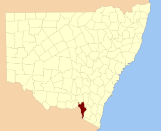
The Towamba River is an open mature wave dominated barrier estuary or perennial river, located in the South Coast region of New South Wales, Australia.

Scout Creek River in Australia

Scout Creek is an urban gully, is located in Hornsby Shire local government area of Sydney, New South Wales, Australia. It is part of the Parramatta River catchment.

References

  1. "Beresford County". Geographical Names Register (GNR) of NSW. Geographical Names Board of New South Wales. OOjs UI icon edit-ltr-progressive.svg