Auckland County

Last updated

Map all coordinates using: OpenStreetMap
Auckland
New South Wales
Auckland NSW.PNG
Location in New South Wales
Lands administrative divisions around Auckland:
Beresford Dampier Pacific Ocean
Wellesley Auckland Pacific Ocean
Croajingolong (Vic) Croajingolong (Vic) Pacific Ocean

Auckland County is one of the 141 cadastral divisions of New South Wales. It is at the extreme south-east of the state, with the Victorian border to the south, and the area to the north of the Brogo River the boundary to the north. It includes Bega, Eden and Merimbula.

The county was named after George Eden, who was the First Earl of Auckland between (1784-1849). [1] In 1852, it had an area of 1,536,000 acres (6,220 km2) and was described as being mountainous with fertile plains. [2]

Parishes within this county

A full list of parishes found within this county; their current LGA and mapping coordinates to the approximate centre of each location is as follows:

ParishLGACoordinates
Bega Bega Valley Shire 36°40′54″S149°54′04″E / 36.68167°S 149.90111°E / -36.68167; 149.90111 (Bega Parish)
Bemboka Bega Valley Shire 36°40′54″S149°37′04″E / 36.68167°S 149.61778°E / -36.68167; 149.61778 (Bemboka Parish)
Bimmil Bega Valley Shire 36°59′54″S149°50′04″E / 36.99833°S 149.83444°E / -36.99833; 149.83444 (Bimmil Parish)
Bondi Snowy Monaro Regional Council 37°06′54″S149°15′04″E / 37.11500°S 149.25111°E / -37.11500; 149.25111 (Bondi Parish)
Bournda Bega Valley Shire 36°48′54″S149°55′04″E / 36.81500°S 149.91778°E / -36.81500; 149.91778 (Bournda Parish)
Boyd Bega Valley Shire 37°00′54″S149°43′04″E / 37.01500°S 149.71778°E / -37.01500; 149.71778 (Boyd Parish)
Bredbendoura Bega Valley Shire 36°45′54″S149°30′04″E / 36.76500°S 149.50111°E / -36.76500; 149.50111 (Bredbendoura Parish)
Brogo Bega Valley Shire 36°37′54″S149°51′04″E / 36.63167°S 149.85111°E / -36.63167; 149.85111 (Brogo Parish)
Bronte Bega Valley Shire 36°34′54″S149°45′04″E / 36.58167°S 149.75111°E / -36.58167; 149.75111 (Bronte Parish)
Buckle Bega Valley Shire 37°18′54″S149°41′04″E / 37.31500°S 149.68444°E / -37.31500; 149.68444 (Buckle Parish)
Burragate Bega Valley Shire 36°58′54″S149°38′04″E / 36.98167°S 149.63444°E / -36.98167; 149.63444 (Burragate Parish)
Candelo Bega Valley Shire 36°43′54″S149°45′04″E / 36.73167°S 149.75111°E / -36.73167; 149.75111 (Candelo Parish)
Cobra Bega Valley Shire 36°53′54″S149°47′04″E / 36.89833°S 149.78444°E / -36.89833; 149.78444 (Cobra Parish)
Colombo Bega Valley Shire 36°33′54″S149°26′04″E / 36.56500°S 149.43444°E / -36.56500; 149.43444 (Colombo Parish)
Coolangubra Bega Valley Shire 36°59′54″S149°30′04″E / 36.99833°S 149.50111°E / -36.99833; 149.50111 (Coolangubra Parish)
Eden Bega Valley Shire 37°03′54″S149°51′04″E / 37.06500°S 149.85111°E / -37.06500; 149.85111 (Eden Parish)
Genoa Snowy Monaro Regional Council 37°08′54″S149°25′04″E / 37.14833°S 149.41778°E / -37.14833; 149.41778 (Genoa Parish)
Gnupa Bega Valley Shire 36°57′54″S149°47′04″E / 36.96500°S 149.78444°E / -36.96500; 149.78444 (Gnupa Parish)
Gooyan Bega Valley Shire 37°14′54″S149°47′04″E / 37.24833°S 149.78444°E / -37.24833; 149.78444 (Gooyan Parish)
Howe Bega Valley Shire 37°21′54″S149°56′04″E / 37.36500°S 149.93444°E / -37.36500; 149.93444 (Howe Parish)
Imlay Bega Valley Shire 37°04′54″S149°44′04″E / 37.08167°S 149.73444°E / -37.08167; 149.73444 (Imlay Parish)
Kameruka Bega Valley Shire 36°44′54″S149°50′04″E / 36.74833°S 149.83444°E / -36.74833; 149.83444 (Kameruka Parish)
Kanoonah Bega Valley Shire 36°55′54″S149°25′04″E / 36.93167°S 149.41778°E / -36.93167; 149.41778 (Kanoonah Parish)
Kiah Bega Valley Shire 37°07′54″S149°56′04″E / 37.13167°S 149.93444°E / -37.13167; 149.93444 (Kiah Parish)
Kokoboreeka Bega Valley Shire 36°23′54″S149°35′04″E / 36.39833°S 149.58444°E / -36.39833; 149.58444 (Kokoboreeka Parish)
Mataganah Bega Valley Shire 36°58′54″S149°34′04″E / 36.98167°S 149.56778°E / -36.98167; 149.56778 (Mataganah Parish)
Meringo Bega Valley Shire 36°41′54″S149°46′04″E / 36.69833°S 149.76778°E / -36.69833; 149.76778 (Meringo Parish)
Mogila Bega Valley Shire 36°41′54″S149°30′04″E / 36.69833°S 149.50111°E / -36.69833; 149.50111 (Mogila Parish)
Mokoreeka Bega Valley Shire 36°27′54″S149°31′04″E / 36.46500°S 149.51778°E / -36.46500; 149.51778 (Mokoreeka Parish)
Mookerwah Bega Valley Shire 36°24′54″S149°43′04″E / 36.41500°S 149.71778°E / -36.41500; 149.71778 (Mookerwah Parish)
Mumbulla Bega Valley Shire 36°29′54″S149°48′04″E / 36.49833°S 149.80111°E / -36.49833; 149.80111 (Mumbulla Parish)
Nalbaugh Bega Valley Shire 37°03′54″S149°23′04″E / 37.06500°S 149.38444°E / -37.06500; 149.38444 (Nalbaugh Parish)
Narrabarba Bega Valley Shire 37°15′54″S149°53′04″E / 37.26500°S 149.88444°E / -37.26500; 149.88444 (Narrabarba Parish)
Nullica Bega Valley Shire 37°07′54″S149°49′04″E / 37.13167°S 149.81778°E / -37.13167; 149.81778 (Nullica Parish)
Numbugga Bega Valley Shire 36°38′54″S149°46′04″E / 36.64833°S 149.76778°E / -36.64833; 149.76778 (Numbugga Parish)
Nungatta Bega Valley Shire 37°12′54″S149°27′04″E / 37.21500°S 149.45111°E / -37.21500; 149.45111 (Nungatta Parish)
Ooranook Bega Valley Shire 36°33′54″S149°34′04″E / 36.56500°S 149.56778°E / -36.56500; 149.56778 (Ooranook Parish)
Pambula Bega Valley Shire 36°52′54″S149°54′04″E / 36.88167°S 149.90111°E / -36.88167; 149.90111 (Pambula Parish)
Pericoe Bega Valley Shire 37°05′54″S149°33′04″E / 37.09833°S 149.55111°E / -37.09833; 149.55111 (Pericoe Parish)
Puen Buen Bega Valley Shire 36°28′54″S149°45′04″E / 36.48167°S 149.75111°E / -36.48167; 149.75111 (Puen Buen Parish)
Sturt Bega Valley Shire 37°11′54″S149°42′04″E / 37.19833°S 149.70111°E / -37.19833; 149.70111 (Sturt Parish)
Tantawangalo Bega Valley Shire 36°45′54″S149°34′04″E / 36.76500°S 149.56778°E / -36.76500; 149.56778 (Tantawangalo Parish)
Towamba Bega Valley Shire 37°07′54″S149°42′04″E / 37.13167°S 149.70111°E / -37.13167; 149.70111 (Towamba Parish)
Victoria Bega Valley Shire 37°20′54″S149°52′04″E / 37.34833°S 149.86778°E / -37.34833; 149.86778 (Victoria Parish)
Waalimma Bega Valley Shire 37°16′54″S149°32′04″E / 37.28167°S 149.53444°E / -37.28167; 149.53444 (Waalimma Parish)
Wallagaraugh Bega Valley Shire 37°19′54″S149°45′04″E / 37.33167°S 149.75111°E / -37.33167; 149.75111 (Wallagaraugh Parish)
Wallagoot Bega Valley Shire 36°43′54″S149°56′04″E / 36.73167°S 149.93444°E / -36.73167; 149.93444 (Wallagoot Parish)
Werri Berri Bega Valley Shire 36°33′45″S149°30′00″E / 36.56250°S 149.50000°E / -36.56250; 149.50000 (Werri Berri Parish)
Wolumla Bega Valley Shire 36°48′54″S149°48′04″E / 36.81500°S 149.80111°E / -36.81500; 149.80111 (Wolumla Parish)
Wonboyn Bega Valley Shire 37°12′54″S149°56′04″E / 37.21500°S 149.93444°E / -37.21500; 149.93444 (Wonboyn Parish)
Wyndham Bega Valley Shire 36°54′49″S149°39′43″E / 36.91361°S 149.66194°E / -36.91361; 149.66194 (Wyndham Parish)
Yambulla Bega Valley Shire 37°11′54″S149°34′04″E / 37.19833°S 149.56778°E / -37.19833; 149.56778 (Yambulla Parish)
Yowaka Bega Valley Shire 36°57′54″S149°50′34″E / 36.96500°S 149.84278°E / -36.96500; 149.84278 (Yowaka Parish)
Yuglamah Bega Valley Shire 36°52′54″S149°30′04″E / 36.88167°S 149.50111°E / -36.88167; 149.50111 (Yuglamah Parish)
Yurammie Bega Valley Shire 36°49′54″S149°40′04″E / 36.83167°S 149.66778°E / -36.83167; 149.66778 (Yurammie Parish)

Related Research Articles

<span class="mw-page-title-main">Gwynedd</span> County and preserved county in Wales

Gwynedd is a county in the north-west of Wales. It borders Anglesey across the Menai Strait to the north, Conwy, Denbighshire, and Powys to the east, Ceredigion over the Dyfi estuary to the south, and the Irish Sea to the west. The city of Bangor is the largest settlement, and the administrative centre is Caernarfon. The preserved county of Gwynedd, which is used for ceremonial purposes, includes the Isle of Anglesey.

<span class="mw-page-title-main">George Eden, 1st Earl of Auckland</span> English politician and colonial administrator

George Eden, 1st Earl of Auckland, was an English Whig politician and colonial administrator. He was thrice First Lord of the Admiralty and also served as Governor-General of India between 1836 and 1842. The province of Auckland, which includes the present regions of Northland, Auckland, Waikato, Bay of Plenty and Gisborne along with the city of Auckland, in New Zealand, was named after him.

<span class="mw-page-title-main">Historic counties of Wales</span> Sub-divisions in Wales

The historic counties of Wales are sub-divisions of Wales. They were used for various functions for several hundred years, but for administrative purposes have been superseded by contemporary sub-national divisions, some of which bear some limited similarity to the historic entities in name and extent. They are alternatively known as ancient counties.

<span class="mw-page-title-main">Merionethshire</span> Historic county of Wales

Merionethshire or Merioneth is one of thirteen historic counties of Wales, a vice county and a former administrative county.

<span class="mw-page-title-main">Denbighshire</span> County in Wales

Denbighshire is a county in the north-east of Wales. It borders the Irish Sea to the north, Flintshire to the east, Wrexham to the southeast, Powys to the south, and Gwynedd and Conwy to the west. Rhyl is the largest town, and Ruthin is the administrative centre. Its borders differ from the historic county of the same name.

<span class="mw-page-title-main">Chirk</span> Town in Wales

Chirk is a town and community in Wrexham County Borough, Wales, 10 miles south of Wrexham, between it and Oswestry. At the 2011 census, it had a population of 4,468. Historically in the traditional county of Denbighshire, and later Clwyd, it has been part of Wrexham County Borough since a local government reorganisation in 1996. The border with the English county of Shropshire is immediately south of the town, on the other side of the River Ceiriog.

<span class="mw-page-title-main">North Wales</span> Geographic region in Wales

North Wales is a region of Wales, encompassing its northernmost areas. It borders mid Wales to the south, England to the east, and the Irish Sea to the north and west. The area is highly mountainous and rural, with Snowdonia National Park and the Clwydian Range and Dee Valley, known for its mountains, waterfalls and trails, wholly within the region. Its population is concentrated in the north-east and northern coastal areas, with significant Welsh-speaking populations in its western and rural areas. North Wales is imprecisely defined, lacking any exact definition or administrative structure. It is commonly defined administratively as its six most northern principal areas, but other definitions exist, with Montgomeryshire historically considered to be part of the region.

<span class="mw-page-title-main">South Wales</span> Region of Wales

South Wales is a loosely defined region of Wales bordered by England to the east and mid Wales to the north. Generally considered to include the historic counties of Glamorgan and Monmouthshire, south Wales extends westwards to include Carmarthenshire and Pembrokeshire. In the western extent, from Swansea westwards, local people would probably recognise that they lived in both south Wales and west Wales. The Brecon Beacons National Park covers about a third of south Wales, containing Pen y Fan, the highest British mountain south of Cadair Idris in Snowdonia.

<span class="mw-page-title-main">Epsom, New Zealand</span> Suburb in Auckland, New Zealand

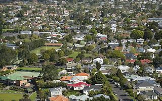
Epsom is a suburb of Auckland, New Zealand. It is located in the centre of the Auckland isthmus between Mount Eden and Greenlane, south of Newmarket, and five km south of Auckland CBD.

<span class="mw-page-title-main">Geography of Wales</span> Overview of the geography of Wales

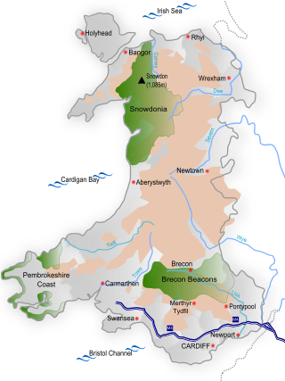
Wales is a country that is part of the United Kingdom and whose physical geography is characterised by a varied coastline and a largely upland interior. It is bordered by England to its east, the Irish Sea to its north and west, and the Bristol Channel to its south. It has a total area of 2,064,100 hectares and is about 170 mi (274 km) from north to south and at least 60 mi (97 km) wide. It comprises 8.35 percent of the land of the United Kingdom. It has a number of offshore islands, by far the largest of which is Anglesey. The mainland coastline, including Anglesey, is about 1,680 mi (2,704 km) in length. As of 2014, Wales had a population of about 3,092,000; Cardiff is the capital and largest city and is situated in the urbanised area of South East Wales.

<span class="mw-page-title-main">Eden, New South Wales</span> Town in New South Wales, Australia

Eden is a coastal town in the South Coast region of New South Wales, Australia. The town is 478 kilometres (297 mi) south of the state capital Sydney and is the most southerly town in New South Wales, located between Nullica Bay to the south and Calle Calle Bay, the northern reach of Twofold Bay, and built on undulating land adjacent to the third-deepest natural harbour in the southern hemisphere, and Snug Cove on its western boundary. At the 2016 census, Eden had a population of 3,151.

<span class="mw-page-title-main">Glen Eden, New Zealand</span> Suburb of Auckland, New Zealand

Glen Eden is a suburb of West Auckland, New Zealand, located at the foothills of Waitākere Ranges. Originally known as Waikumete, the suburb gained the name Glen Eden in 1921. The suburb is in the Waitākere Ward, one of the thirteen administrative areas of Auckland governed by Auckland Council.

<span class="mw-page-title-main">Lands administrative divisions of New South Wales</span>

For lands administrative purposes, New South Wales is divided into 141 counties, which are further divided into parishes. The counties were first set down in the Colony of New South Wales, which later became the Australian state of New South Wales.

<span class="mw-page-title-main">Northumberland County, New South Wales</span> Cadastral in New South Wales, Australia

Northumberland County was one of the original Nineteen Counties in New South Wales and is now one of the 141 Cadastral divisions of New South Wales. It included the area to the north of Broken Bay, which compasses the Central Coast region and Lake Macquarie as well as Newcastle(Greater Newcastle) in the Hunter region. It was bounded by the part of the Hawkesbury River to the south, the Macdonald River to the south-west, and the Hunter River to the north.

<span class="mw-page-title-main">Camden County, New South Wales</span> Cadastral in New South Wales, Australia

Camden County was one of the original Nineteen Counties in New South Wales and is now one of the 141 Cadastral divisions of New South Wales. It included the coastal area near Wollongong south to the Shoalhaven River, and also inland encompassing Berrima and Picton. Its western boundary was the Wollondilly River. The first settlement in the area was Camden Park, established by John Macarthur in 1806, just across the Nepean River from Cumberland County. It was the first land across the Nepean to be settled. Camden is a present-day suburb of Sydney in the same area, although parts of it are in Cumberland.

<span class="mw-page-title-main">St Vincent County</span> Cadastral in Australian Capital Territory

St Vincent County was one of the original Nineteen Counties in New South Wales and is now one of the 141 Cadastral divisions of New South Wales. It included the south coast area encompassing Batemans Bay, Ulladulla, Jervis Bay and inland to Braidwood. The Shoalhaven River is the boundary to the north and west, and the Deua River the boundary to the south.

<span class="mw-page-title-main">Argyle County</span> Cadastral in New South Wales, Australia

Argyle County was one of the original Nineteen Counties in New South Wales and is now one of the 141 Cadastral divisions of New South Wales. It includes the area around Goulburn. It is bounded by Lake George in the south-west, the Shoalhaven River in the east, and the Wollondilly River in the north-east.

<span class="mw-page-title-main">Bathurst County</span> Cadastral in New South Wales, Australia

Bathurst County was one of the original Nineteen Counties in New South Wales and is now one of the 141 Cadastral divisions of New South Wales. It includes the area to the south-west of Bathurst to Cowra and Orange. The Lachlan River is the boundary to the south-west, the Belubula River forms part of the northern boundary, with the Fish River on the northeastern boundary. Blayney is located roughly in the middle.

Willink, New York is a former town in Western New York, United States. The name was derived from Willem Willink, one of the original investors of the Holland Land Company.

<i>The Southern Star</i> (newspaper, Bega, New South Wales)

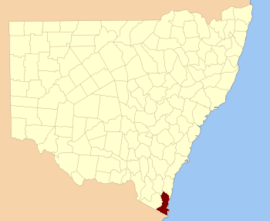
The Southern Star was a bi-weekly English language newspaper published on Wednesday and Saturdays in Bega, New South Wales, Australia. It was previously published as The Bega Gazette and County of Auckland Advertiser, and The Bega Gazette and Eden District or Southern Coast Advertiser.

References

  1. "Auckland County". Geographical Names Register (GNR) of NSW. Geographical Names Board of New South Wales. OOjs UI icon edit-ltr-progressive.svg
  2. "Old Welsh Books with English Translations", The Land of Gold: the Companion for the Welsh Emigrant to Australia, 1852