Cadell County

Last updated

Cadell
New South Wales
Cadell NSW.PNG
Location in New South Wales
Lands administrative divisions around Cadell:
Wakool Townsend Townsend
Wakool Cadell Townsend
Gunbower (Vic) Rodney (Vic) Moira (Vic)

Cadell County is one of the 141 Cadastral divisions of New South Wales. It contains the city of Moama.

Cadell County was named in honour of Francis Cadell (1822–1879), river navigator and entrepreneur [1] who in 1852, in preparation for the launch of his steamer service, explored the Murray River in a canvas boat, travelling 1,300 miles (2,100 km) downstream from Swan Hill. [2]

Cadel_cfounty_nsw_1876_map Cadel cfounty nsw 1876 map.png
Cadel_cfounty_nsw_1876_map

Parishes within this county

A full list of parishes found within this county; their current LGA and mapping coordinates to the approximate centre of each location is as follows:

ParishLGACoordinates
Bama Murray River Council 36°00′54″S144°51′04″E / 36.01500°S 144.85111°E / -36.01500; 144.85111 (Bama)
Benarca Murray River Council 35°57′54″S144°38′04″E / 35.96500°S 144.63444°E / -35.96500; 144.63444 (Benarca)
Bunnaloo Murray River Council 35°45′54″S144°41′04″E / 35.76500°S 144.68444°E / -35.76500; 144.68444 (Bunnaloo)
Burrumbury Murray River Council 35°49′54″S144°25′04″E / 35.83167°S 144.41778°E / -35.83167; 144.41778 (Burrumbury)
Caldwell Murray River Council 35°39′54″S144°28′04″E / 35.66500°S 144.46778°E / -35.66500; 144.46778 (Caldwell)
Caloola Murray River Council 36°00′54″S144°44′04″E / 36.01500°S 144.73444°E / -36.01500; 144.73444 (Caloola)
Caloola Murray River Council 35°59′54″S144°43′04″E / 35.99833°S 144.71778°E / -35.99833; 144.71778 (Caloola)
Gotha Murray River Council 35°37′54″S144°35′04″E / 35.63167°S 144.58444°E / -35.63167; 144.58444 (Gotha)
Gothog Murray River Council 35°40′54″S144°41′04″E / 35.68167°S 144.68444°E / -35.68167; 144.68444 (Gothog)
Gulpa Murray River Council 35°50′54″S144°51′04″E / 35.84833°S 144.85111°E / -35.84833; 144.85111 (Gulpa)
Marah Murray River Council 35°33′54″S144°29′04″E / 35.56500°S 144.48444°E / -35.56500; 144.48444 (Marah)
Mars Murray River Council 35°53′54″S144°39′04″E / 35.89833°S 144.65111°E / -35.89833; 144.65111 (Mars)
Mathoura Murray River Council 35°45′54″S144°46′04″E / 35.76500°S 144.76778°E / -35.76500; 144.76778 (Mathoura)
Moama Murray River Council 36°03′54″S144°48′04″E / 36.06500°S 144.80111°E / -36.06500; 144.80111 (Moama)
Moira Murray River Council 35°55′54″S144°49′04″E / 35.93167°S 144.81778°E / -35.93167; 144.81778 (Moira)
Nallam Murray River Council 35°49′54″S144°46′04″E / 35.83167°S 144.76778°E / -35.83167; 144.76778 (Nallam)
Perricoota Murray River Council 35°57′54″S144°33′04″E / 35.96500°S 144.55111°E / -35.96500; 144.55111 (Perricoota)
Porthole Murray River Council 35°35′54″S144°21′04″E / 35.59833°S 144.35111°E / -35.59833; 144.35111 (Porthole)
Tamar Murray River Council 35°48′54″S144°34′04″E / 35.81500°S 144.56778°E / -35.81500; 144.56778 (Tamar)
Tantonan Murray River Council 35°42′54″S144°23′04″E / 35.71500°S 144.38444°E / -35.71500; 144.38444 (Tantonan)
Tataila Murray River Council 36°02′54″S144°42′04″E / 36.04833°S 144.70111°E / -36.04833; 144.70111 (Tataila)
Thule Murray River Council 35°37′54″S144°24′04″E / 35.63167°S 144.40111°E / -35.63167; 144.40111 (Thule)
Thyra Murray River Council 35°49′54″S144°41′04″E / 35.83167°S 144.68444°E / -35.83167; 144.68444 (Thyra)
Tomara Murray River Council 35°49′54″S144°28′04″E / 35.83167°S 144.46778°E / -35.83167; 144.46778 (Tomara)
Toorangabby Murray River Council 35°54′54″S144°28′04″E / 35.91500°S 144.46778°E / -35.91500; 144.46778 (Toorangabby)
Wirringan Murray River Council 35°40′54″S144°35′04″E / 35.68167°S 144.58444°E / -35.68167; 144.58444 (Wirringan)
Womboota Murray River Council 35°53′54″S144°33′04″E / 35.89833°S 144.55111°E / -35.89833; 144.55111 (Womboota)
Wongal Murray River Council 35°44′54″S144°35′04″E / 35.74833°S 144.58444°E / -35.74833; 144.58444 (Wongal)
Yarraman Murray River Council 35°45′54″S144°30′04″E / 35.76500°S 144.50111°E / -35.76500; 144.50111 (Yarraman)

Related Research Articles

<span class="mw-page-title-main">Wellington County, New South Wales</span> Cadastral in New South Wales, Australia

Wellington County is a county in New South Wales, Australia, which was one of the original Nineteen Counties. The town of Wellington is near the north-eastern edge. The Bell River is the boundary to the west, and the Cudgegong River to the north. It includes land on both sides of the Macquarie River.

<span class="mw-page-title-main">Lands administrative divisions of New South Wales</span>

For lands administrative purposes, New South Wales is divided into 141 counties, which are further divided into parishes. The counties were first set down in the Colony of New South Wales, which later became the Australian state of New South Wales.

<span class="mw-page-title-main">Northumberland County, New South Wales</span> Cadastral in New South Wales, Australia

Northumberland County was one of the original Nineteen Counties in New South Wales and is now one of the 141 Cadastral divisions of New South Wales. It included the area to the north of Broken Bay, which compasses the Central Coast region and Lake Macquarie as well as Newcastle(Greater Newcastle) in the Hunter region. It was bounded by the part of the Hawkesbury River to the south, the Macdonald River to the south-west, and the Hunter River to the north.

<span class="mw-page-title-main">Camden County, New South Wales</span> Cadastral in New South Wales, Australia

Camden County was one of the original Nineteen Counties in New South Wales and is now one of the 141 Cadastral divisions of New South Wales. It included the coastal area near Wollongong south to the Shoalhaven River, and also inland encompassing Berrima and Picton. Its western boundary was the Wollondilly River. The first settlement in the area was Camden Park, established by John Macarthur in 1806, just across the Nepean River from Cumberland County. It was the first land across the Nepean to be settled. Camden is a present-day suburb of Sydney in the same area, although parts of it are in Cumberland.

<span class="mw-page-title-main">St Vincent County</span> Cadastral in Australian Capital Territory

St Vincent County was one of the original Nineteen Counties in New South Wales and is now one of the 141 Cadastral divisions of New South Wales. It included the south coast area encompassing Batemans Bay, Ulladulla, Jervis Bay and inland to Braidwood. The Shoalhaven River is the boundary to the north and west, and the Deua River the boundary to the south.

<span class="mw-page-title-main">Argyle County</span> Cadastral in New South Wales, Australia

Argyle County was one of the original Nineteen Counties in New South Wales and is now one of the 141 Cadastral divisions of New South Wales. It includes the area around Goulburn. It is bounded by Lake George in the south-west, the Shoalhaven River in the east, and the Wollondilly River in the north-east.

<span class="mw-page-title-main">Bathurst County</span> Cadastral in New South Wales, Australia

Bathurst County was one of the original Nineteen Counties in New South Wales and is now one of the 141 Cadastral divisions of New South Wales. It includes the area to the south-west of Bathurst to Cowra and Orange. The Lachlan River is the boundary to the south-west, the Belubula River forms part of the northern boundary, with the Fish River on the northeastern boundary. Blayney is located roughly in the middle.

<span class="mw-page-title-main">Cooper County, New South Wales</span> Cadastral in New South Wales, Australia

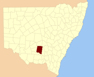
Cooper County is one of the 141 Cadastral divisions of New South Wales. It contains the town of Barellan. The Murrumbidgee River is the southern boundary.

<span class="mw-page-title-main">Sturt County</span> Cadastral in New South Wales, Australia

Sturt County is one of the 141 Cadastral divisions of New South Wales. It contains the locality of Carrathool. The Murrumbidgee River is the southern boundary.

<span class="mw-page-title-main">Cowley County, New South Wales</span> Cadastral in New South Wales, Australia

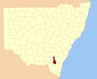
Cowley County is one of the 141 Cadastral divisions of New South Wales. It contains the locality of Cavan. It was originally bordered on the north, east and part of the south by the Murrumbidgee River, and on the west by the Goodradigbee River. A large part of the county was transferred to the Commonwealth to make the Australian Capital Territory in 1909, with the remaining part the area to the north-west of the ACT as far north as the Burrinjuck Dam, and thin strips of land along the western, southern and south-eastern borders of the ACT.

<span class="mw-page-title-main">Waradgery County</span> Cadastral in New South Wales, Australia

Waradgery County is one of the 141 Cadastral divisions of New South Wales. It contains the town of Hay. It includes the area between the Lachlan River and the Murrumbidgee River where they meet. The Lachlan River is the northern boundary of the county, and the Murrumbidgee for a small section is the southern boundary, but the county also includes some of the land to the south of the Murrumbidgee near Hay.

<span class="mw-page-title-main">Nicholson County</span> Cadastral in New South Wales, Australia

Nicholson County is one of the 141 Cadastral divisions of New South Wales. It contains the towns of Hillston, Goolgowi, Gunbar, Merriwagga, Goorawin and Langtree. The Lachlan River is its north-western boundary.

<span class="mw-page-title-main">Auckland County</span> Cadastral in New South Wales, Australia

Auckland County is one of the 141 cadastral divisions of New South Wales. It is at the extreme south-east of the state, with the Victorian border to the south, and the area to the north of the Brogo River the boundary to the north. It includes Bega, Eden and Merimbula.

<span class="mw-page-title-main">Finch County</span> Cadastral in New South Wales, Australia

Finch County is one of the 141 Cadastral divisions of New South Wales. It is bounded by the Narran River in the west, the Barwon River to the south and east, and the Queensland border to the north. It includes Lightning Ridge.

<span class="mw-page-title-main">Irrara County</span> Cadastral in New South Wales, Australia

Irrara County is one of the 141 Cadastral divisions of New South Wales. It is located south of the border with Queensland, east of the Paroo River, and west of the Warrego River.

<span class="mw-page-title-main">Macquarie County</span> Cadastral in New South Wales, Australia

Macquarie County is one of the 141 Cadastral divisions of New South Wales, Australia. It is bordered to the north by the Apsley River, and to the south by the Manning River. It includes Port Macquarie and the area around it.

<span class="mw-page-title-main">Parry County</span> Cadastral in New South Wales, Australia

Parry County is one of the 141 Cadastral divisions of New South Wales. It is bounded by the Peel River and Cockburn River on the north, near Tamworth. The Moonbi Range is on the eastern boundary, and the Peel Range on the western boundary. The Great Dividing Range is the boundary to the south-east. It includes the towns of Dungowan, Ogunbil, Woolomin, Loomberah, Piallamore and Nundle.

<span class="mw-page-title-main">Pottinger County</span> Cadastral in New South Wales, Australia

Pottinger County is one of the 141 Cadastral divisions of New South Wales. It is located to the south west of the Namoi River and Mooki River, near Gunnedah.

<span class="mw-page-title-main">Selwyn County, New South Wales</span> Cadastral in New South Wales, Australia

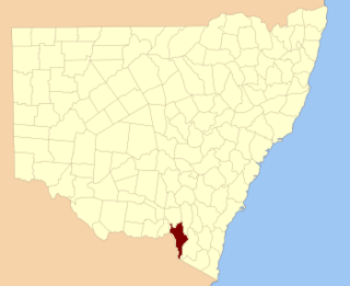
Selwyn County is one of the 141 Cadastral divisions of New South Wales. It is located to the east of the Murray River, with part of the Tumut River as its boundary to the north-east. It includes Mount Kosciuszko, the highest mountain in Australia.

<span class="mw-page-title-main">Vernon County, New South Wales</span> Cadastral in New South Wales, Australia

Vernon County is one of the 141 Cadastral divisions of New South Wales, Australia. The Macleay River is part of the border in the north-east. It includes Walcha.

References

  1. "Cadell County". Geographical Names Register (GNR) of NSW. Geographical Names Board of New South Wales. OOjs UI icon edit-ltr-progressive.svg
  2. "Present condition and prospects of south australia". South Australian Register. 14 September 1852. p. 1S. Retrieved 4 November 2010.