
Raleigh is the capital city of the U.S. state of North Carolina and the seat of Wake County. It is the second-most populous city in North Carolina, after Charlotte. Raleigh is the tenth-most populous city in the Southeast, the 41st-most populous city in the U.S., and the largest city of the Research Triangle metro area. Raleigh is known as the "City of Oaks" for its many oak trees, which line the streets in the heart of the city. The city covers a land area of 147.6 sq mi (382 km2). The U.S. Census Bureau counted the city's population as 467,665 in the 2020 census. It is one of the fastest-growing cities in the United States. The city of Raleigh is named after Sir Walter Raleigh, who established the now-lost Roanoke Colony in present-day Dare County.
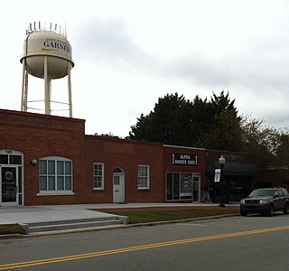
Garner is a town in Wake County, North Carolina, United States and a suburb of Raleigh. The population is 31,159 as of the 2020 census. The city limits are entirely within Wake County, though portions of unincorporated Wake County, as well as the Cleveland community in northern Johnston County, have Garner mailing addresses. It is part of the Research Triangle region of North Carolina and serves as a bedroom community for the region.
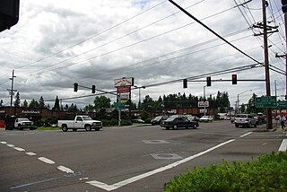
Raleigh Hills is a census-designated place and neighborhood in Washington County, Oregon within the metropolitan area of Portland, Oregon, United States. It is located in the southwest hills in Washington County, with Beaverton to the west, West Slope to the north, and Progress and Garden Home to the south. As of the 2000 census, the census-designated place had a total population of 5,865.
Raleigh County may refer to:
The Geographical Names Board of New South Wales, a statutory authority of the Department of Customer Service in the Government of New South Wales, is the official body for naming and recording details of places and geographical names in the state of New South Wales, Australia.
Mount Raleigh, elevation 3,132 m (10,276 ft), is one of the principal summits of the Pacific Ranges of the Coast Mountains of southern British Columbia in Canada. It is located just southeast of the confluence of the Southgate and Bishop Rivers, northeast of the head of Bute Inlet, and is the highest summit south of the Bishop River's divide with the Lillooet River at Ring Pass, which is at the southeastern edge of the Lillooet Icefield and just north of the Pemberton Icecap. It is also the highest peak south of the pass between the upper basins of Chilko Lake and the Taseko Lakes, just north of which is Monmouth Mountain at 3,182 m (10,440 ft).

Darbalara is a rural community on the east bank of the junction of the Murrumbidgee River and Tumut River in the Riverina. It is situated by road, about 25 kilometres north east of Gundagai and 25 kilometres south of Coolac.
Gloucester was an electoral district of the Legislative Assembly in the Australian state of New South Wales, originally created in 1880, partly replacing Williams, and named after Gloucester or Gloucester County. In 1920, with the introduction of proportional representation, it was absorbed into Oxley, along with Raleigh. It was recreated in 1927, and abolished in 1988 and replaced by Myall Lakes and Port Stephens.
Raleigh was an electoral district of the Legislative Assembly in the Australian state of New South Wales, originally created in 1894, partly replacing Macleay, and named after Raleigh County. In 1920, with the introduction of proportional representation, it was absorbed into Oxley, along with Gloucester. It was recreated in 1927 and abolished in 1981 and partly replaced by Coffs Harbour.
Raleigh is a small town in the Mid North Coast region of New South Wales, Australia, in Bellingen Shire. At the 2011 census, Raleigh had a population of 550. The town is south of Coffs Harbour and Sawtell and north of Nambucca Heads. It is located in Raleigh County and is perhaps named after it. It has one school, Raleigh Public School, which is located opposite a Norco dairy factory. A railway station on the North Coast line opened in 1915, but was subsequently closed and demolished.

Bellinger River, an open and trained mature wave dominated, barrier estuary, is located in the Mid North Coast region of New South Wales, Australia.

Winding Gulf is an unincorporated community in Raleigh County, West Virginia, United States. Winding Gulf is located on Winding Gulf, south of Sophia.
Clive Raleigh Evatt was an Australian politician, barrister and raconteur. He was a member of the New South Wales Legislative Assembly from 1939 until 1959. At various times he sat as a member of the Industrial Labor Party, Labor Party and as an independent.
Packsville is an unincorporated community in Raleigh County, West Virginia, United States. Packsville is located on the Little Marsh Fork, 4.4 miles (7.1 km) south-southeast of Sylvester.
The Bellingen Shire Courier-Sun is a weekly newspaper published in Bellingen, New South Wales, Australia by Australian Community Media. It has been published under a variety of titles since 1889, including The Northern Courier, The Raleigh Sun, Seaboard Valley Star and The Bellinger Courier-Sun.

Oxley is an electoral district of the Legislative Assembly in the Australian state of New South Wales.
Raleigh, an electoral district of the Legislative Assembly in the Australian state of New South Wales, has had two incarnations, the first from 1894 to 1920, the second from 1927 to 1981.
Giinagay Way is a road in the Mid North Coast region of New South Wales linking the towns of Warrell Creek, Macksville, Nambucca Heads and Urunga to Pacific Highway. It runs along a former section of the highway between Eungai Creek and Raleigh that was bypassed by a new parallel alignment between 2016 and 2018.
