Gough County

Last updated

Map all coordinates using: OpenStreetMap  
Download coordinates as: KML  ·  GPX
Gough
New South Wales
Gough NSW.PNG
Location in New South Wales
Lands administrative divisions around Gough:
Arrawatta Clive Clive
Arrawatta Gough Gresham
Murchison Hardinge Clarke

Gough County is one of the 141 Cadastral divisions of New South Wales.

Gough County was named in honour of Field Marshal Sir Hugh Gough, first Viscount Gough (1779-1869). [1]

Hugh Gough, 1st Viscount Gough British field marshal

Field Marshal Hugh Gough, 1st Viscount Gough, was a British Army officer. After serving as a junior officer at the seizure of the Cape of Good Hope during the French Revolutionary Wars, Gough commanded the 2nd Battalion of the 87th Regiment of Foot during the Peninsular War. After serving as commander-in-chief of the British forces in China during the First Opium War, he became Commander-in-Chief, India and led the British forces in action against the Mahrattas defeating them decisively at the conclusion of the Gwalior Campaign and then commanded the troops that defeated the Sikhs during both the First Anglo-Sikh War and the Second Anglo-Sikh War under which the British suffered the most losses and lost battles since the Napoleonic Wars.

Parishes

A full list of parishes found within this county; their current LGA and mapping coordinates to the approximate centre of each location is as follows:

Local government in Australia third tier of government in Australia

Local government in Australia is the third tier of government in Australia administered by the states and territories, which in turn are beneath the federal tier. Local government is not mentioned in the Constitution of Australia and two referenda in the 1970s and 1980s to alter the Constitution relating to local government were unsuccessful. Every state government recognises local government in their respective constitutions. Unlike Canada or the United States, there is only one level of local government in each state, with no distinction such as cities and counties.

ParishLGACoordinates
Anderson Inverell Shire 29°48′54″S151°18′04″E / 29.81500°S 151.30111°E / -29.81500; 151.30111 (Anderson Parish)
Arvid Glen Innes Severn Council 29°21′54″S151°29′04″E / 29.36500°S 151.48444°E / -29.36500; 151.48444 (Arvid Parish)
Auburn Vale Inverell Shire 29°44′54″S151°01′34″E / 29.74833°S 151.02611°E / -29.74833; 151.02611 (Auburn Vale Parish)
Balaclava Inverell Shire 29°47′54″S151°31′04″E / 29.79833°S 151.51778°E / -29.79833; 151.51778 (Balaclava Parish)
Bald Nob Glen Innes Severn Council 29°40′54″S151°58′04″E / 29.68167°S 151.96778°E / -29.68167; 151.96778 (Bald Nob Parish)
Beardy Plains Glen Innes Severn Council 29°42′54″S151°49′04″E / 29.71500°S 151.81778°E / -29.71500; 151.81778 (Beardy Plains Parish)
Ben Lomond Armidale Regional Council 29°59′54″S151°41′04″E / 29.99833°S 151.68444°E / -29.99833; 151.68444 (Ben Lomond Parish)
Blair Hill Glen Innes Severn Council 29°50′54″S151°52′04″E / 29.84833°S 151.86778°E / -29.84833; 151.86778 (Blair Hill Parish)
Boyd Glen Innes Severn Council 29°36′54″S151°49′04″E / 29.61500°S 151.81778°E / -29.61500; 151.81778 (Boyd Parish)
Bundar Glen Innes Severn Council 29°22′54″S151°37′04″E / 29.38167°S 151.61778°E / -29.38167; 151.61778 (Bundar Parish)
Campbell Inverell Shire 29°41′54″S151°12′04″E / 29.69833°S 151.20111°E / -29.69833; 151.20111 (Campbell Parish)
Clifton Glen Innes Severn Council 29°48′54″S151°40′04″E / 29.81500°S 151.66778°E / -29.81500; 151.66778 (Clifton Parish)
Clive Inverell Shire 29°50′54″S151°08′04″E / 29.84833°S 151.13444°E / -29.84833; 151.13444 (Clive Parish)
Deepwater Glen Innes Severn Council 29°29′54″S151°52′04″E / 29.49833°S 151.86778°E / -29.49833; 151.86778 (Deepwater Parish)
Diehard Glen Innes Severn Council 29°40′54″S152°03′04″E / 29.68167°S 152.05111°E / -29.68167; 152.05111 (Diehard Parish)
Ditmas Glen Innes Severn Council 29°41′54″S151°39′04″E / 29.69833°S 151.65111°E / -29.69833; 151.65111 (Ditmas Parish)
Dumaresq Tenterfield Shire 29°11′54″S151°24′04″E / 29.19833°S 151.40111°E / -29.19833; 151.40111 (Dumaresq Parish)
Eden Inverell Shire 29°51′54″S151°21′04″E / 29.86500°S 151.35111°E / -29.86500; 151.35111 (Eden Parish)
Elsmore Inverell Shire 29°48′54″S151°12′04″E / 29.81500°S 151.20111°E / -29.81500; 151.20111 (Elsmore Parish)
Fladbury Glen Innes Severn Council 29°31′54″S151°38′04″E / 29.53167°S 151.63444°E / -29.53167; 151.63444 (Fladbury Parish)
Flagstone Tenterfield Shire 29°13′54″S151°33′04″E / 29.23167°S 151.55111°E / -29.23167; 151.55111 (Flagstone Parish)
Fletcher Glen Innes Severn Council 29°51′54″S151°42′04″E / 29.86500°S 151.70111°E / -29.86500; 151.70111 (Fletcher Parish)
Glen Innes Glen Innes Severn Council 29°43′54″S151°46′04″E / 29.73167°S 151.76778°E / -29.73167; 151.76778 (Glen Innes Parish)
Gordon Glen Innes Severn Council 29°33′54″S151°32′04″E / 29.56500°S 151.53444°E / -29.56500; 151.53444 (Gordon Parish)
Hamilton Glen Innes Severn Council 29°25′54″S151°33′04″E / 29.43167°S 151.55111°E / -29.43167; 151.55111 (Hamilton Parish)
Herbert Inverell Shire 29°50′54″S151°14′04″E / 29.84833°S 151.23444°E / -29.84833; 151.23444 (Herbert Parish)
Highland Home Tenterfield Shire 29°18′54″S151°41′04″E / 29.31500°S 151.68444°E / -29.31500; 151.68444 (Highland Home Parish)
Kingsgate Glen Innes Severn Council 29°45′54″S151°58′04″E / 29.76500°S 151.96778°E / -29.76500; 151.96778 (Kingsgate Parish)
Lands End Glen Innes Severn Council 29°16′54″S151°29′04″E / 29.28167°S 151.48444°E / -29.28167; 151.48444 (Lands End Parish)
Llangothlin Glen Innes Severn Council 29°59′54″S151°41′04″E / 29.99833°S 151.68444°E / -29.99833; 151.68444 (Llangothlin Parish)
Louis Glen Innes Severn Council 29°34′54″S151°46′04″E / 29.58167°S 151.76778°E / -29.58167; 151.76778 (Louis Parish)
Macintyre Inverell Shire 29°56′54″S151°35′04″E / 29.94833°S 151.58444°E / -29.94833; 151.58444 (Macintyre Parish)
Mann Glen Innes Severn Council 29°42′54″S152°06′04″E / 29.71500°S 152.10111°E / -29.71500; 152.10111 (Mann Parish)
Marowan Glen Innes Severn Council 29°51′54″S151°48′04″E / 29.86500°S 151.80111°E / -29.86500; 151.80111 (Marowan Parish)
Mitchell Glen Innes Severn Council 29°41′54″S151°55′04″E / 29.69833°S 151.91778°E / -29.69833; 151.91778 (Mitchell Parish)
Mount Mitchell Glen Innes Severn Council 29°59′54″S151°48′04″E / 29.99833°S 151.80111°E / -29.99833; 151.80111 (Mount Mitchell Parish)
Muir Tenterfield Shire 29°15′54″S151°27′04″E / 29.26500°S 151.45111°E / -29.26500; 151.45111 (Muir Parish)
Newstead Inverell Shire 29°49′54″S151°23′04″E / 29.83167°S 151.38444°E / -29.83167; 151.38444 (Newstead Parish)
Paradise Inverell Shire 29°54′54″S151°31′04″E / 29.91500°S 151.51778°E / -29.91500; 151.51778 (Paradise Parish)
Paradise North Glen Innes Severn Council 29°18′54″S151°34′59″E / 29.31500°S 151.58306°E / -29.31500; 151.58306 (Paradise North Parish)
Parkes Glen Innes Severn Council 29°27′54″S151°58′04″E / 29.46500°S 151.96778°E / -29.46500; 151.96778 (Parkes Parish)
Rangers Valley Glen Innes Severn Council 29°32′54″S151°47′04″E / 29.54833°S 151.78444°E / -29.54833; 151.78444 (Rangers Valley Parish)
Robertson Glen Innes Severn Council 29°40′54″S152°09′04″E / 29.68167°S 152.15111°E / -29.68167; 152.15111 (Robertson Parish)
Ross Inverell Shire 29°43′54″S151°27′04″E / 29.73167°S 151.45111°E / -29.73167; 151.45111 (Ross Parish)
Rusden Glen Innes Severn Council 29°43′54″S151°53′04″E / 29.73167°S 151.88444°E / -29.73167; 151.88444 (Rusden Parish)
Scone Glen Innes Severn Council 29°29′54″S151°36′04″E / 29.49833°S 151.60111°E / -29.49833; 151.60111 (Scone Parish)
Scott Glen Innes Severn Council 29°31′54″S152°01′04″E / 29.53167°S 152.01778°E / -29.53167; 152.01778 (Scott Parish)
Severn Glen Innes Severn Council 29°33′54″S151°51′04″E / 29.56500°S 151.85111°E / -29.56500; 151.85111 (Severn Parish)
Stonehenge Glen Innes Severn Council 29°48′54″S151°43′04″E / 29.81500°S 151.71778°E / -29.81500; 151.71778 (Stonehenge Parish)
Strachan Glen Innes Severn Council 29°22′54″S151°42′04″E / 29.38167°S 151.70111°E / -29.38167; 151.70111 (Strachan Parish)
Strathbogie Glen Innes Severn Council 29°29′54″S151°31′04″E / 29.49833°S 151.51778°E / -29.49833; 151.51778 (Strathbogie Parish)
Strathbogie North Glen Innes Severn Council 29°23′54″S151°34′04″E / 29.39833°S 151.56778°E / -29.39833; 151.56778 (Strathbogie North Parish)
Swanbrook Inverell Shire 29°42′54″S151°17′04″E / 29.71500°S 151.28444°E / -29.71500; 151.28444 (Swanbrook Parish)
Swanvale Inverell Shire 29°43′54″S151°22′04″E / 29.73167°S 151.36778°E / -29.73167; 151.36778 (Swanvale Parish)
Tent Hill Glen Innes Severn Council 29°25′46″S151°40′08″E / 29.42944°S 151.66889°E / -29.42944; 151.66889 (Tent Hill Parish)
The Brothers Glen Innes Severn Council 29°46′54″S152°05′04″E / 29.78167°S 152.08444°E / -29.78167; 152.08444 (The Brothers Parish)
Waterloo Glen Innes Severn Council 29°43′54″S151°35′04″E / 29.73167°S 151.58444°E / -29.73167; 151.58444 (Waterloo Parish)
Wellingrove Glen Innes Severn Council 29°36′54″S151°34′04″E / 29.61500°S 151.56778°E / -29.61500; 151.56778 (Wellingrove Parish)
Wellington Glen Innes Severn Council 29°35′54″S151°39′04″E / 29.59833°S 151.65111°E / -29.59833; 151.65111 (Wellington Parish)
Wellington North Tenterfield Shire 29°17′54″S151°39′04″E / 29.29833°S 151.65111°E / -29.29833; 151.65111 (Wellington North Parish)
Wellington Vale Glen Innes Severn Council 29°23′54″S151°46′04″E / 29.39833°S 151.76778°E / -29.39833; 151.76778 (Wellington Vale Parish)
Yarrow Glen Innes Severn Council 29°52′54″S152°00′04″E / 29.88167°S 152.00111°E / -29.88167; 152.00111 (Yarrow Parish)
Yarrowford Glen Innes Severn Council 29°36′54″S151°46′04″E / 29.61500°S 151.76778°E / -29.61500; 151.76778 (Yarrowford Parish)

Related Research Articles

Gough Island Island in the South Atlantic

Gough Island, also known historically as Gonçalo Álvares after the Portuguese explorer, is a rugged volcanic island in the South Atlantic Ocean. It is a dependency of Tristan da Cunha and part of the British overseas territory of Saint Helena, Ascension and Tristan da Cunha. It is about 400 km (250 mi) south-east of the Tristan da Cunha archipelago, 2,400 km (1,500 mi) north-east from South Georgia Island, 2,700 km (1,700 mi) west from Cape Town, and over 3,200 km (2,000 mi) from the nearest point of South America.

South Creek (New South Wales) river in New South Wales, Australia

The South Creek or Wianamatta, a creek that is part of the Hawkesbury-Nepean catchment, is located on the Cumberland Plain, also referred to as Greater Western Sydney, New South Wales, Australia.

The Geographical Names Board of New South Wales, a statutory authority of the Land and Property Information division, Department of Finance and Services in the Government of New South Wales, is the official body for naming and recording details of places and geographical names in the state of New South Wales, Australia.

Wolli Creek river in New South Wales, Australia

Wolli Creek is an urban watercourse of the Cooks River catchment located in the southern suburbs of Sydney, in New South Wales, Australia.

Michael Andrew Gough is an English former domestic cricketer and umpire. He was a right-handed batsman and a right-arm off-break bowler. Gough is an international umpire and is a member of the Elite Panel of ICC Umpires, representing the England and Wales Cricket Board.

Ian Gough Welsh rugby union player

Ian Gough is a former Wales international rugby union footballer. His usual position was lock forward. He made his debut for the Wales national rugby union team against South Africa in 1998, and was a regular thereafter, including playing in the 2006 Six Nations Championship, and the mid year series against Argentina. He also played within the Irish under-19 international team.

Darbalara, New South Wales Town in New South Wales, Australia

Darbalara is a rural community on the east bank of the junction of the Murrumbidgee River and Tumut River in the Riverina. It is situated by road, about 25 kilometres north east of Gundagai and 25 kilometres south of Coolac.

Gloucester County, New South Wales Cadastral in New South Wales, Australia

Gloucester County was one of the original Nineteen Counties in New South Wales, and is now one of the 141 cadastral divisions of New South Wales. It includes the area around Port Stephens. It is bounded on the north and west by the Manning River, and on the south-west by the Williams River.

St Vincent County Cadastral in Australian Capital Territory

St Vincent County was one of the original Nineteen Counties in New South Wales and is now one of the 141 Cadastral divisions of New South Wales. It included the south coast area encompassing Batemans Bay, Ulladulla, Jervis Bay and inland to Braidwood. The Shoalhaven River is the boundary to the north and west, and the Deua River the boundary to the south.

Cowper County Cadastral in New South Wales, Australia

Cowper County, New South Wales is one of the 141 Cadastral divisions of New South Wales.

Kennedy County Cadastral in New South Wales, Australia

Kennedy County is one of the 141 Cadastral divisions of New South Wales. It is located to the west of the Bogan River in the area around Tottenham and Tullamore.

Mootwingee County Cadastral in New South Wales, Australia

Mootwingee County, New South Wales is one of the 141 Cadastral divisions of New South Wales.

Armidale was an electoral district of the Legislative Assembly in the Australian state of New South Wales, originally created in 1894, partly replacing New England, and named after and including Armidale. In 1920, with the introduction of proportional representation, it was absorbed into Northern Tablelands, along with Gough and Tenterfield. It was recreated in 1927 and abolished in 1981 and partly replaced by the recreated Northern Tablelands.

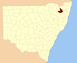
Gough was an electoral district of the Legislative Assembly in the Australian state of New South Wales, which replaced Glen Innes and part of Gwydir in 1904 and was named after the Gough County, which includes the town of Glen Innes. In 1920, with the introduction of proportional representation, it was absorbed into Northern Tablelands, along with Armidale and Tenterfield.

Tenterfield was an electoral district of the Legislative Assembly in the Australian state of New South Wales, originally created in 1859, partly replacing New England and Macleay, and named after, and including, Tenterfield. In 1920, with the introduction of proportional representation, it was absorbed into Northern Tablelands, along with Armidale and Gough. It was recreated in 1927 and abolished in 1981 and partly replaced by the recreated Northern Tablelands.

Glen Innes was an electoral district of the Legislative Assembly in the Australian state of New South Wales, named after Glen Innes. It was created in 1880 and gained a second member in 1889, with voters casting two votes with the two leading candidates being elected. In 1894, it became a single-member electorate and, in 1904, it was abolished and replaced by Gough.

Gough Map Late Medieval map of the island of Great Britain

The Gough Map or Bodleian Map is a Late Medieval map of the island of Great Britain. Its precise date of production and authorship are unknown. It is named after Richard Gough, who bequeathed the map to the Bodleian Library in 1809. He acquired the map from the estate of the antiquarian Thomas "Honest Tom" Martin in 1774. Numerous copies of it have been made, with an interactive online version created at Queen's University, Belfast. It measures 115 x 56 cm.

John George Gough, was one of the founders of the New South Wales Labour Party, initially the Labour Electoral League, the first political Labour movement in Australia. He was also one of Labour's five-member leadership group when the party first made its appearance in the New South Wales parliament in 1891. Representing Young, he was first elected in 1889 to the parliament's lower house as a member of the Protectionist Party, which produced Australia's first two prime ministers, Edmund Barton and Alfred Deakin. From 1891 to 1894 he represented Labour. Proud that his mother was Australian-born, he was a strong nationalist and republican. John Gough’s maternal grandmother was half-aboriginal. He is the only one of Labor’s founding fathers who has been found to have had aboriginal ancestry.

Tallawong railway station Sydney Metro railway station

Tallawong railway station, originally known as Cudgegong Road railway station, is a station near the intersection of Cudgegong and Schofield Roads, Rouse Hill, in Sydney, Australia. The station is the terminus of the Metro North West Line to Chatswood that will later be extended through the Sydney central business district to Bankstown. Beyond the station lies a train depot.

Blowering, New South Wales

Blowering, New South wales is a rural locality in the Snowy Mountains of New South wales and a civil Parish of Buccleuch County.

References

  1. "Gough". Geographical Names Register (GNR) of NSW. Geographical Names Board of New South Wales . Retrieved 3 August 2013. OOjs UI icon edit-ltr-progressive.svg