Wynyard County

Last updated

Map all coordinates using: OpenStreetMap  
Download coordinates as: KML
Wynyard
New South Wales
Wynyard NSW.PNG
Location in New South Wales
Lands administrative divisions around Wynyard:
Bourke Clarendon Harden
Mitchell Wynyard Buccleuch
Goulburn Selwyn Selwyn
Map of Wynyard county from 1897 showing the parishes Wynyard county NSW 1897.jpg
Map of Wynyard county from 1897 showing the parishes
The Murrumbidgee River at Gundagai; the boundary between Wynyard and Clarendon MurrumbidgeeAtGundagai.jpg
The Murrumbidgee River at Gundagai; the boundary between Wynyard and Clarendon

Wynyard County is one of the 141 Cadastral divisions of New South Wales. It contains the city of Wagga Wagga. The Murrumbidgee River lies on the northern edge of the county, and the Tumut River on the eastern edge.

Wynyard County was named in honour of Major-General Robert Henry Wynyard (1802-1864). [1]

Parishes within this county

A full list of parishes found within this county; their current LGA and mapping coordinates to the approximate centre of each location is as follows:

ParishLGACoordinates
Adelong Snowy Valleys Council 35°18′54″S148°02′04″E / 35.31500°S 148.03444°E / -35.31500; 148.03444 (Adelong)
Bago Snowy Valleys Council 35°37′54″S147°59′04″E / 35.63167°S 147.98444°E / -35.63167; 147.98444 (Bago)
Nangus Cootamundra-Gundagai Regional Council 35°08′54″S147°58′04″E / 35.14833°S 147.96778°E / -35.14833; 147.96778 (Bangus)
Batlow Snowy Valleys Council 35°27′54″S148°10′04″E / 35.46500°S 148.16778°E / -35.46500; 148.16778 (Batlow)
Belmore City of Wagga Wagga 35°28′54″S147°53′04″E / 35.48167°S 147.88444°E / -35.48167; 147.88444 (Belmore Parish)
Blanch City of Wagga Wagga 35°16′54″S147°51′04″E / 35.28167°S 147.85111°E / -35.28167; 147.85111 (Blanch)
Book Book City of Wagga Wagga 35°21′54″S147°30′04″E / 35.36500°S 147.50111°E / -35.36500; 147.50111 (Book Book)
Borambola City of Wagga Wagga 35°09′54″S147°38′04″E / 35.16500°S 147.63444°E / -35.16500; 147.63444 (Borambola)
Bulalgee Greater Hume Shire Council 35°33′54″S147°42′04″E / 35.56500°S 147.70111°E / -35.56500; 147.70111 (Bulalgee)
Califat Snowy Valleys Council 35°14′54″S148°05′04″E / 35.24833°S 148.08444°E / -35.24833; 148.08444 (Califat)
Carabost Greater Hume Shire Council 35°36′54″S147°41′04″E / 35.61500°S 147.68444°E / -35.61500; 147.68444 (Carabost)
Coreinbob City of Wagga Wagga 35°14′54″S147°39′04″E / 35.24833°S 147.65111°E / -35.24833; 147.65111 (Coreinbob)
Courabyra Snowy Valleys Council 35°39′54″S148°01′04″E / 35.66500°S 148.01778°E / -35.66500; 148.01778 (Courabyra)
Cunningdroo City of Wagga Wagga 35°08′54″S147°32′04″E / 35.14833°S 147.53444°E / -35.14833; 147.53444 (Cunningdroo)
Dutzon Snowy Valleys Council 35°21′54″S147°54′04″E / 35.36500°S 147.90111°E / -35.36500; 147.90111 (Dutzon)
Ellerslie Snowy Valleys Council 35°14′54″S147°56′04″E / 35.24833°S 147.93444°E / -35.24833; 147.93444 (Ellerslie)
Euadera Snowy Valleys Council 35°15′54″S148°00′04″E / 35.26500°S 148.00111°E / -35.26500; 148.00111 (Euadera)
Gadara Snowy Valleys Council 35°18′54″S148°07′04″E / 35.31500°S 148.11778°E / -35.31500; 148.11778 (Gadara)
Gilmore Snowy Valleys Council 35°22′54″S148°09′04″E / 35.38167°S 148.15111°E / -35.38167; 148.15111 (Gilmore)
Goldspink Snowy Valleys Council 35°37′54″S147°55′04″E / 35.63167°S 147.91778°E / -35.63167; 147.91778 (Goldspink)
Gregadoo City of Wagga Wagga 35°14′54″S147°27′04″E / 35.24833°S 147.45111°E / -35.24833; 147.45111 (Gregadoo)
Gumly Gumly City of Wagga Wagga 35°09′54″S147°28′04″E / 35.16500°S 147.46778°E / -35.16500; 147.46778 (Gumly Gumly)
Hillas Snowy Valleys Council 35°29′54″S148°00′04″E / 35.49833°S 148.00111°E / -35.49833; 148.00111 (Hillas)
Hindmarsh Snowy Valleys Council 35°27′54″S148°06′04″E / 35.46500°S 148.10111°E / -35.46500; 148.10111 (Hindmarsh)
Humula City of Wagga Wagga 35°28′54″S147°46′04″E / 35.48167°S 147.76778°E / -35.48167; 147.76778 (Humula)
Keajura City of Wagga Wagga 35°19′54″S147°39′04″E / 35.33167°S 147.65111°E / -35.33167; 147.65111 (Keajura)
Kilgowla City of Wagga Wagga 35°23′54″S147°38′04″E / 35.39833°S 147.63444°E / -35.39833; 147.63444 (Kilgowla)
Kyeamba City of Wagga Wagga 35°23′54″S147°29′04″E / 35.39833°S 147.48444°E / -35.39833; 147.48444 (Kyeamba)
Livingstone City of Wagga Wagga 35°22′54″S147°26′04″E / 35.38167°S 147.43444°E / -35.38167; 147.43444 (Livingstone)
Mate City of Wagga Wagga 35°26′54″S147°51′04″E / 35.44833°S 147.85111°E / -35.44833; 147.85111 (Mate)
Minjary Snowy Valleys Council 35°15′54″S148°10′04″E / 35.26500°S 148.16778°E / -35.26500; 148.16778 (Minjary)
Mundarlo Cootamundra-Gundagai Regional Council 35°06′54″S147°51′04″E / 35.11500°S 147.85111°E / -35.11500; 147.85111 (Mundarlo)
Murraguldrie City of Wagga Wagga 35°27′54″S147°36′04″E / 35.46500°S 147.60111°E / -35.46500; 147.60111 (Murraguldrie)
Nacki Nacki Snowy Valleys Council 35°21′54″S147°58′04″E / 35.36500°S 147.96778°E / -35.36500; 147.96778 (Nacki Nacki)
Oberne City of Wagga Wagga 35°20′54″S147°48′04″E / 35.34833°S 147.80111°E / -35.34833; 147.80111 (Oberne)
Rowan City of Wagga Wagga 35°14′54″S147°22′04″E / 35.24833°S 147.36778°E / -35.24833; 147.36778 (Rowan)
Selwyn Snowy Valleys Council 35°33′54″S148°09′04″E / 35.56500°S 148.15111°E / -35.56500; 148.15111 (Selwyn)
South Gundagai Cootamundra-Gundagai Regional Council 35°03′54″S148°09′04″E / 35.06500°S 148.15111°E / -35.06500; 148.15111 (South Gundagai)
South Wagga Wagga City of Wagga Wagga 35°07′54″S147°21′04″E / 35.13167°S 147.35111°E / -35.13167; 147.35111 (South Wagga Wagga)
Tarcutta Cootamundra-Gundagai Regional Council 35°10′54″S147°45′04″E / 35.18167°S 147.75111°E / -35.18167; 147.75111 (Tarcutta)
Tarrabandra Cootamundra-Gundagai Regional Council 35°08′54″S148°10′04″E / 35.14833°S 148.16778°E / -35.14833; 148.16778 (Tarrabandra)
Tumut Snowy Valleys Council 35°16′54″S148°10′04″E / 35.28167°S 148.16778°E / -35.28167; 148.16778 (Tumut)
Tywong City of Wagga Wagga 35°14′54″S147°33′04″E / 35.24833°S 147.55111°E / -35.24833; 147.55111 (Tywong)
Umbango City of Wagga Wagga 35°26′54″S147°46′04″E / 35.44833°S 147.76778°E / -35.44833; 147.76778 (Umbango)
Umutbee City of Wagga Wagga 35°14′54″S147°45′04″E / 35.24833°S 147.75111°E / -35.24833; 147.75111 (Umutbee)
Wallace Snowy Valleys Council 35°17′54″S147°54′04″E / 35.29833°S 147.90111°E / -35.29833; 147.90111 (Wallace)
Wereboldera Snowy Valleys Council 35°22′54″S148°13′04″E / 35.38167°S 148.21778°E / -35.38167; 148.21778 (Wereboldera)
Willie Ploma Cootamundra-Gundagai Regional Council 35°08′54″S148°03′04″E / 35.14833°S 148.05111°E / -35.14833; 148.05111 (Willie Ploma)
Wondalga Snowy Valleys Council 35°23′54″S148°05′04″E / 35.39833°S 148.08444°E / -35.39833; 148.08444 (Wondalga)
Wood Greater Hume Shire Council 35°37′54″S147°50′04″E / 35.63167°S 147.83444°E / -35.63167; 147.83444 (Wood)
Woomahrigong City of Wagga Wagga 35°16′54″S147°25′04″E / 35.28167°S 147.41778°E / -35.28167; 147.41778 (Woomahrigong)
Yabtree City of Wagga Wagga 35°06′54″S147°45′04″E / 35.11500°S 147.75111°E / -35.11500; 147.75111 (Yabtree)
Yaven Cootamundra-Gundagai Regional Council 35°11′54″S147°51′04″E / 35.19833°S 147.85111°E / -35.19833; 147.85111 (Yaven)

Related Research Articles

<span class="mw-page-title-main">Murrumbidgee River</span> Major river in southeastern Australia

The Murrumbidgee River is a major tributary of the Murray River within the Murray–Darling basin and the second longest river in Australia. It flows through the Australian state of New South Wales and the Australian Capital Territory, descending 1,500 metres (4,900 ft) over 1,485 kilometres (923 mi), generally in a west-northwesterly direction from the foot of Peppercorn Hill in the Fiery Range of the Snowy Mountains towards its confluence with the Murray River near Boundary Bend.

<span class="mw-page-title-main">Wagga Wagga</span> City in New South Wales, Australia

Wagga Wagga is a major regional city in the Riverina region of New South Wales, Australia. Straddling the Murrumbidgee River, with an urban population of more than 56,000 as of June 2018, Wagga Wagga is the state's largest inland city, and is an important agricultural, military, and transport hub of Australia. The ninth largest inland city in Australia, Wagga Wagga is located midway between the two largest cities in Australia—Sydney and Melbourne—and is the major regional centre for the Riverina and South West Slopes regions.

<span class="mw-page-title-main">Sturt Highway</span> Australian national highway

Sturt Highway is an Australian national highway in New South Wales, Victoria, and South Australia. It is an important road link for the transport of passengers and freight between Sydney and Adelaide and the regions along the route.

<span class="mw-page-title-main">Olympic Highway</span> Highway in New South Wales

Olympic Highway is a 317-kilometre (197 mi) rural road in the central western and south-eastern Riverina regions of New South Wales, Australia. It services rural communities, links Hume Highway with Mid-Western Highway, and provides part of an alternate road link between Sydney and Albury via Bathurst and Cowra as well as servicing Wagga Wagga, linking with Sturt Highway.

<span class="mw-page-title-main">Riverina</span> Region in New South Wales, Australia

The Riverina is an agricultural region of south-western New South Wales, Australia. The Riverina is distinguished from other Australian regions by the combination of flat plains, warm to hot climate and an ample supply of water for irrigation. This combination has allowed the Riverina to develop into one of the most productive and agriculturally diverse areas of Australia. Bordered on the south by the state of Victoria and on the east by the Great Dividing Range, the Riverina covers those areas of New South Wales in the Murray and Murrumbidgee drainage zones to their confluence in the west.

<span class="mw-page-title-main">Tarcutta</span> Town in New South Wales, Australia

Tarcutta is a town in south-western New South Wales, Australia. The town is 438 kilometres (272 mi) south-west of Sydney, 3 kilometres (1.9 mi) east of the Hume Highway, It was proclaimed as a village on 28 October 1890. As of 2016, the town had a population of 446.

<span class="mw-page-title-main">Bomen, New South Wales</span> Suburb of Wagga Wagga, New South Wales, Australia

Bomen is a northern suburb of Wagga Wagga in southern New South Wales, Australia. The suburb is dominated by industrial enterprises including Cargill Beef, Watties, the Wagga Wagga Livestock Marketing Centre (saleyards). The suburb is also home to Wagga Wagga's secondary railway station on the Main Southern line, when the line waited for the construction of a bridge over the Murrumbidgee River. New streets in Bomen are to be named after sheep and cattle breeds.

<span class="mw-page-title-main">Wagga Wagga railway station</span> Railway station in New South Wales, Australia

Wagga Wagga railway station is a railway station open for passenger services on the Main South line connecting Sydney and Melbourne. It has been heritage-listed, especially on account of its historical and architectural significance. A museum is on the premises. As of 2021, two daily passenger trains in each direction served the City of Wagga Wagga.

<span class="mw-page-title-main">Hampden Bridge, Wagga Wagga</span> Bridge in Wagga Wagga, New South Wales

The Hampden Bridge was a heritage-listed wooden Allan Truss bridge over the Murrumbidgee River in Wagga Wagga, in New South Wales, Australia. It was officially opened to traffic on 11 November 1895 and named in honour of the NSW Governor Sir Henry Robert Brand, 2nd Viscount Hampden. The bridge carried the Olympic Highway, formerly the Olympic Way, between 1963 until the bridge's closure to highway traffic in October 1995, replaced by the Wiradjuri Bridge. The Hampden Bridge was subsequently converted to local traffic use, then pedestrian use only, and finally demolished in 2014.

<span class="mw-page-title-main">Murrumbidgee River railway bridge, Wagga Wagga</span> Bridge in New South Wales, Australia

The Murrumbidgee River railway bridge is a former railway bridge that carried the Main Southern railway line across the Murrumbidgee River in Wagga Wagga, Australia. The original bridge, erected in 1881, was replaced in 2006.

<span class="mw-page-title-main">City of Wagga Wagga</span> Local government area in New South Wales, Australia

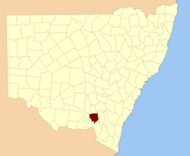
City of Wagga Wagga is a local government area in the Riverina region of southern New South Wales, Australia.

<span class="mw-page-title-main">Lands administrative divisions of New South Wales</span>

For lands administrative purposes, New South Wales is divided into 141 counties, which are further divided into parishes. The counties were first set down in the Colony of New South Wales, which later became the Australian state of New South Wales.

Wynyard was an electoral district for the Legislative Assembly in the Australian State of New South Wales from 1904 to 1913, including the town of Tumut and named after Wynyard County. It replaced all of the abolished district of Tumut and part of the abolished district of Gundagai. Its only member was Robert Donaldson. The Federal Capital Territory was removed from New South Wales in 1911 and Wynyard was abolished in the 1912 redistribution. Most of the district, including the town of Tumut was absorbed by the district of Yass and the balance was distributed between the surrounding districts of Cootamundra, Wagga Wagga and Albury.

Corowa was an electoral district of the Legislative Assembly of the Australian state of New South Wales, taking its name from town of Corowa on the Murray River.

<span class="mw-page-title-main">East Wagga Wagga</span> Suburb of Wagga Wagga, New South Wales, Australia

East Wagga Wagga is a suburb of Wagga Wagga, New South Wales. East Wagga Wagga is mostly an industrial area located approximately 3 km (2 mi) east south-east of the central business district on the Sturt Highway. Home Base Wagga Wagga, WIN Television, Country Energy depot, Riverina Water County Council headquarters, Australia Post Mail Sorting Centre, Busabout Wagga Wagga depot, Australian Clay Target Association (ACTA) National Office and ACTA shooting range are located within East Wagga Wagga.

The Tarcutta Creek, part of the Murray Darling basin, is mostly a perennial stream located in the Riverina region of New South Wales, Australia.

Wagga Wagga, an electoral district of the Legislative Assembly in the Australian state of New South Wales, has had three incarnations, the first from 1894 to 1904, the second from 1913 to 1920, and the third from 1927 to the present.

<i>Gundagai Times and Tumut, Adelong and Murrumbidgee District Advertiser</i>

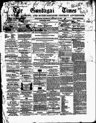
The Gundagai Times and Tumut, Adelong, and Murrumbidgee District Advertiser, often referred to as simply the Gundagai Times, was a newspaper published in Gundagai, New South Wales, Australia from 1868 to 1931. It was a direct successor of The Wynyard Times and Tumut and Adelong Advertiser and The Tumut and Adelong Times, published in Tumut, New South Wales, and was absorbed into The Gundagai Independent in 1931.

The Electoral district of Pastoral Districts of Lachlan and Lower Darling was an electorate of the New South Wales Legislative Council at a time when some of its members were elected and the balance were appointed by the Governor. It was a new electorate created in 1851 by the expansion of the Legislative Council to 54, 18 to be appointed and 36 elected. The district covered the south west of New South Wales was named after the Lachlan and Darling Rivers. On its eastern side were the districts of County of Bathurst and Counties of King and Georgiana, to the north was the Pastoral Districts of Wellington and Bligh and to the south was the Counties of Murray and St Vincent. Polling was to occur in the towns of Binalong, Wagga Wagga, Balranald, Canowindra, Gundagai and Yass.

Wynyard, an electoral district of the Legislative Assembly in the Australian state of New South Wales was created in 1904 and abolished in 1913.

References

  1. "Wynyard". Geographical Names Board of New South Wales . Retrieved 23 September 2020.