Evelyn County, New South Wales

Last updated

Map all coordinates using: OpenStreetMap  
Download coordinates as: KML  ·  GPX
Evelyn
New South Wales
Evelyn NSW.PNG
Location in New South Wales
Lands administrative divisions around Evelyn:
South Australia Poole Tongowoko
South AustraliaEvelyn Yantara
South Australia Farnell Mootwingee

Evelyn County is one of the 141 Cadastral divisions of New South Wales, Australia.

Evelyn County is named in honour of Police Magistrate Evelyn Pitfield Shirley Sturt (1816–1885) who was the brother of Charles Sturt. [1]

Parishes within this county

A full list of parishes found within this county; their current LGA and mapping coordinates to the approximate centre of each location is as follows:

ParishLGACoordinates
Arnheim Unincorporated 30°03′54″S141°50′40″E / 30.06500°S 141.84444°E / -30.06500; 141.84444 (Arnheim)
Boulka Unincorporated 30°00′59″S141°05′50″E / 30.01639°S 141.09722°E / -30.01639; 141.09722 (Boulka)
Broughton Unincorporated 30°21′42″S141°14′36″E / 30.36167°S 141.24333°E / -30.36167; 141.24333 (Broughton)
Bullia Unincorporated 30°18′31″S141°39′57″E / 30.30861°S 141.66583°E / -30.30861; 141.66583 (Bullia)
Coally Unincorporated 29°51′00″S141°50′39″E / 29.85000°S 141.84417°E / -29.85000; 141.84417 (Coally)
Coopayandra Unincorporated 30°19′40″S141°50′00″E / 30.32778°S 141.83333°E / -30.32778; 141.83333 (Coopayandra)
Essie Unincorporated 29°50′23″S141°08′05″E / 29.83972°S 141.13472°E / -29.83972; 141.13472 (Essie)
Gayer Unincorporated 30°21′50″S142°00′06″E / 30.36389°S 142.00167°E / -30.36389; 142.00167 (Gayer)
Gidgee Unincorporated 29°54′11″S141°21′10″E / 29.90306°S 141.35278°E / -29.90306; 141.35278 (Gidgee)
Gununah Unincorporated 30°00′03″S141°58′38″E / 30.00083°S 141.97722°E / -30.00083; 141.97722 (Gununah)
Haynes Unincorporated 30°24′24″S141°04′48″E / 30.40667°S 141.08000°E / -30.40667; 141.08000 (Haynes)
King Unincorporated 29°47′23″S142°00′00″E / 29.78972°S 142.00000°E / -29.78972; 142.00000 (King)
Marracoota Unincorporated 30°27′28″S141°30′23″E / 30.45778°S 141.50639°E / -30.45778; 141.50639 (Marracoota)
Milparinka Unincorporated 29°43′39″S141°51′08″E / 29.72750°S 141.85222°E / -29.72750; 141.85222 (Milparinka)
Milring Unincorporated 29°54′29″S141°40′53″E / 29.90806°S 141.68139°E / -29.90806; 141.68139 (Milring)
Moolook Unincorporated 30°09′04″S141°07′08″E / 30.15111°S 141.11889°E / -30.15111; 141.11889 (Moolook)
Mount Blackwood Unincorporated 29°48′37″S141°31′10″E / 29.81028°S 141.51944°E / -29.81028; 141.51944 (Mount Blackwood)
Nardoo Unincorporated 30°14′06″S141°21′35″E / 30.23500°S 141.35972°E / -30.23500; 141.35972 (Nardoo)
Orr Unincorporated 29°47′37″S141°49′55″E / 29.79361°S 141.83194°E / -29.79361; 141.83194 (Orr)
Packsaddle Unincorporated 30°30′01″S141°40′39″E / 30.50028°S 141.67750°E / -30.50028; 141.67750 (Packsaddle)
Paradise Unincorporated 29°40′04″S141°08′05″E / 29.66778°S 141.13472°E / -29.66778; 141.13472 (Paradise)
Pidgerie Unincorporated 30°05′07″S141°22′09″E / 30.08528°S 141.36917°E / -30.08528; 141.36917 (Pidgerie)
Pingally Unincorporated 30°12′31″S141°29′32″E / 30.20861°S 141.49222°E / -30.20861; 141.49222 (Pingally)
Pingbilly Unincorporated 30°07′11″S141°34′06″E / 30.11972°S 141.56833°E / -30.11972; 141.56833 (Pingbilly)
Punnyakunya Unincorporated 29°58′45″S141°15′42″E / 29.97917°S 141.26167°E / -29.97917; 141.26167 (Punnyakunya)
Quinyambi Unincorporated 30°18′40″S141°05′05″E / 30.31111°S 141.08472°E / -30.31111; 141.08472 (Quinyambi)
Rocky Glen Unincorporated 29°39′28″S141°41′10″E / 29.65778°S 141.68611°E / -29.65778; 141.68611 (Rocky Glen)
Sanpah Unincorporated 30°32′10″S141°21′43″E / 30.53611°S 141.36194°E / -30.53611; 141.36194 (Sanpah)
Scott Unincorporated 29°38′31″S142°01′00″E / 29.64194°S 142.01667°E / -29.64194; 142.01667 (Scott)
Utah Unincorporated 30°04′48″S142°03′23″E / 30.08000°S 142.05639°E / -30.08000; 142.05639 (Utah)
Wheeland Unincorporated 30°15′37″S141°14′37″E / 30.26028°S 141.24361°E / -30.26028; 141.24361 (Wheeland)
Whitty Unincorporated 30°12′34″S141°05′06″E / 30.20944°S 141.08500°E / -30.20944; 141.08500 (Whitty)
Wirratcha Unincorporated 29°50′55″S142°00′44″E / 29.84861°S 142.01222°E / -29.84861; 142.01222 (Wirratcha)
Wobaduck Unincorporated 30°26′00″S141°13′42″E / 30.43333°S 141.22833°E / -30.43333; 141.22833 (Wobaduck)
Wonominta Unincorporated 30°15′16″S142°00′06″E / 30.25444°S 142.00167°E / -30.25444; 142.00167 (Wonominta)
Wydjah Unincorporated 30°00′35″S141°37′52″E / 30.00972°S 141.63111°E / -30.00972; 141.63111 (Wydjah)
Wygah Unincorporated 30°01′02″S141°25′22″E / 30.01722°S 141.42278°E / -30.01722; 141.42278 (Wygah)
Yancarraman Unincorporated 30°30′25″S141°30′21″E / 30.50694°S 141.50583°E / -30.50694; 141.50583 (Yancarraman)
Yandama Unincorporated 29°40′40″S141°21′10″E / 29.67778°S 141.35278°E / -29.67778; 141.35278 (Yandama)
Yandaminta Unincorporated 29°39′12″S141°31′10″E / 29.65333°S 141.51944°E / -29.65333; 141.51944 (Yandaminta)
Yarramurtie Unincorporated 30°10′54″S141°50′19″E / 30.18167°S 141.83861°E / -30.18167; 141.83861 (Yarramurtie)

Related Research Articles

Evelyn Pitfield Shirley Sturt

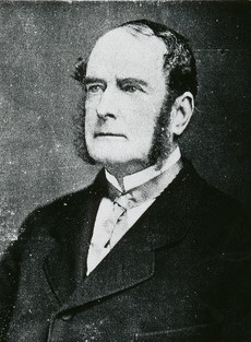
Evelyn Pitfield Shirley Sturt was born in Dorset, England. He was the youngest son of Thomas Lenox Napier Sturt, a puisne judge in Bengal for the British East India Company, and Jeanette or Jeannette, née Wilson. One of his older brothers was the Australian explorer Charles Sturt.

Utah Parish, New South Wales is a remote rural locality and civil parish of Evelyn County in far northwest New South Wales. located at 30°04′48″S 142°03′23″E.

Scott, New South Wales New South Wales, Australia

Scott, New South Wales is a remote rural locality and civil parish of Evelyn County in far northwest New South Wales. located at 29°38′31″S 142°01′00″E.

Mount Blackwood, New South Wales New South Wales, Australia

Mount Blackwood, New South Wales located at 29°48′37″S 141°31′10″E, is a remote rural locality and civil parish of Evelyn County in far northwest New South Wales. located at 30°04′42″S 142°45′50″E, east of the Silver City Highway . The geography of the parish is mostly the flat, arid landscape of the Channel Country. The parish has a Köppen climate classification of BWh.

Coally, New South Wales New South Wales, Australia

Coally is a remote rural locality and civil parish of Evelyn County, New South Wales in far northwest New South Wales located at 29°51′00″S 141°50′39″E.

Whitty is a remote rural locality and civil parish of Evelyn County in far northwest New South Wales. located at 30°12′34″S 141°05′06″E.

Mouloonk is a remote rural locality and civil parish of Evelyn County in far northwest New South Wales. located at 30°09′04″S 141°07′08″E.

Quintyambi is a remote rural locality and civil parish of Evelyn County in far northwest New South Wales. located at 30°18′40″S 141°05′05″E.

Parish of Essie

The Parish of Essie, New South Wales is a remote civil parish of Evelyn County, New South Wales in far northwest New South Wales, located at 29.839722°S 141.134722°E, on the border with South Australia.

Parish of Paradise (Evelyn County)

Parish of Paradise, New South Wales is a remote civil parish of Evelyn County, New South Wales in far northwest New South Wales. located at 29.850000°S 141.844167°E on the border with South Australia.

Pingbilly, New South Wales

Pingbilly, New South Wales is a remote rural locality and civil parish of Evelyn County, New South Wales in far northwest New South Wales.

Punnyakunya, New South Wales

Punnyakunya, New South Wales is a remote rural locality and civil parish of Evelyn County, New South Wales in far northwest New South Wales.

Sanpah, New South Wales

Sanpah, New South Wales is a remote rural locality and civil parish of Evelyn County, New South Wales in far northwest New South Wales.

Utah Parish, New South Wales is a remote rural locality and civil parish of Evelyn County, New South Wales in far northwest New South Wales.

Wheeland, New South Wales

Wheeland, New South Wales is a remote rural locality and civil parish of Evelyn County, New South Wales in far northwest New South Wales.

Wobaduck, New South Wales

Wobaduck, New South Wales is a remote rural locality and civil parish of Evelyn County, New South Wales in far northwest New South Wales.

Yandama, New South Wales

Yandama Parish is a remote rural locality and civil parish of Evelyn County, New South Wales in far northwest New South Wales.

Yandaminta, New South Wales

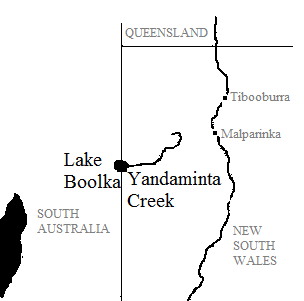
Yandaminta Parish is a remote rural locality and civil parish of Evelyn County, New South Wales in far northwest New South Wales.

Yarramurtie, New South Wales

Yarramurtie Parish is a remote rural locality and civil parish of Evelyn County, New South Wales in far northwest New South Wales.

Wonominta, New South Wales is a remote rural locality and civil parish of Evelyn County in far northwest New South Wales. located at 30°18′40″S 141°05′05″E.

References

  1. "Evelyn County". Geographical Names Register (GNR) of NSW. Geographical Names Board of New South Wales. OOjs UI icon edit-ltr-progressive.svg