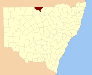
Narran New South Wales | |||||||||||||||
---|---|---|---|---|---|---|---|---|---|---|---|---|---|---|---|
Location in New South Wales | |||||||||||||||
|
Narran County is one of the 141 Cadastral divisions of New South Wales. It is bounded by the Culgoa River on the west, the Narran River in the east, the Queensland border in the north, and the Barwon River in the south. It includes Goodooga and the area to the north of Brewarrina.
The Culgoa River is a river that is part of the Darling catchment within the Murray–Darling basin and is located in South West Queensland.
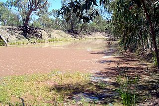
Narran River, a watercourse of the Barwon catchment within the Murray–Darling basin, is located in the Southern Downs district of Queensland and Orana district of New South Wales, Australia.
Queensland is the second-largest and third-most populous state in the Commonwealth of Australia. Situated in the north-east of the country, it is bordered by the Northern Territory, South Australia and New South Wales to the west, south-west and south respectively. To the east, Queensland is bordered by the Coral Sea and Pacific Ocean. To its north is the Torres Strait, with Papua New Guinea located less than 200 km across it from the mainland. The state is the world's sixth-largest sub-national entity, with an area of 1,852,642 square kilometres (715,309 sq mi).
A third river runs thought Narran County - the Bokhara River with Goodooga being on its eastern bank. The three rivers - the Narran, the Bokhara, and the Culgoa - are branches of the Balonne River and all three enter the Barwon River separately. The confluence of the Culgoa and the Barwon rivers is the start of the Darling River.
The Bokhara River, a watercourse that is part of the Barwon catchment within the Murray–Darling basin, is located in the South Downs region of Queensland, flowing downstream into the north–western slopes of New South Wales, Australia. It flows through the lower Balonne floodplain.
The Balonne River, part of the Murray-Darling Basin system, is a short and important part of the inland river group of South West Queensland, Australia.
Barwon River, a perennial river that is part of the Murray–Darling basin, is located in the north-west slopes and Orana regions of New South Wales, Australia.
Narran is believed to be derived from a local Aboriginal word. [1]
Indigenous Australians are the Aboriginal and Torres Strait Islander peoples of Australia, descended from groups that existed in Australia and surrounding islands before British colonisation. The time of arrival of the first Indigenous peoples on the continent and nearby islands is a matter of debate among researchers. The earliest conclusively human remains found in Australia are those of Mungo Man LM3 and Mungo Lady, which have been dated to around 50,000 years BP. Recent archaeological evidence from the analysis of charcoal and artefacts revealing human use suggests a date as early as 65,000 BP. Luminescence dating has suggested habitation in Arnhem Land as far back as 60,000 years BP. Genetic research has inferred a date of habitation as early as 80,000 years BP. Other estimates have ranged up to 100,000 years and 125,000 years BP.
A full list of parishes found within this county; their current LGA and mapping coordinates to the approximate centre of each location is as follows:
Local government in Australia is the third tier of government in Australia administered by the states and territories, which in turn are beneath the federal tier. Local government is not mentioned in the Constitution of Australia and two referenda in the 1970s and 1980s to alter the Constitution relating to local government were unsuccessful. Every state government recognises local government in their respective constitutions. Unlike Canada or the United States, there is only one level of local government in each state, with no distinction such as cities and counties.
The Culgoa National Park is a protected national park that is located in the north-west region of New South Wales, in eastern Australia. The 35,239-hectare (87,080-acre) national park is located approximately 660 kilometres (410 mi) northwest of Sydney. The nearest town is Brewarrina, 120 kilometres (75 mi) away. The park's northern boundary is defined by part of the state border between New South Wales and Queensland.
The Darling River is the third longest river in Australia, measuring 1,472 kilometres (915 mi) from its source in northern New South Wales to its confluence with the Murray River at Wentworth, New South Wales. Including its longest contiguous tributaries it is 2,844 km (1,767 mi) long, making it the longest river system in Australia.
Walgett is a town in northern New South Wales, Australia, and the seat of Walgett Shire. It is near the junctions of the Barwon and Namoi Rivers and the Kamilaroi and Castlereagh Highways. In 2011, the town of Walgett had a population of 2,267 including 1,004 Indigenous persons and 1,073 non-Indigenous Australian-born persons. The balance of the population was born overseas.
Clyde County is one of the 141 Cadastral divisions of the Australian state of New South Wales. It is located between the Bogan River and Barwon River in the area between them where they join. This is the area to the south of Brewarrina, as far east as the Carinda area. A very small part of the Macquarie River and Castlereagh River is also part of the boundary in the north-east.
Culgoa County is one of the 141 Cadastral divisions of New South Wales. It is bounded by the Warrego River in the west, and the Culgoa River in the east.
Finch County is one of the 141 Cadastral divisions of New South Wales. It is bounded by the Narran River in the west, the Barwon River to the south and east, and the Queensland border to the north. It includes Lightning Ridge.
Gunderbooka County is one of the 141 Cadastral divisions of New South Wales. The Warrego River is the western boundary, and the Culgoa River and Darling River is the south-eastern boundary. It includes the area down to where the Warrego meets the Darling, to the north of Bourke.
Goodooga is a town in the Australian state of New South Wales in Brewarrina Shire on the eastern bank of the Bokhara River. It is near Brewarrina and Lightning Ridge, its closest neighbour. The town lies 20 kilometres south of the Queensland border. Goodooga is an Aboriginal word meaning, according to some "Yam". However it has been proposed that it derives from "guduu+ga", 'at the place of the Murray cod' [guduu], rather than "gudugaa", a species of yam.
The Moonie River is a river in Shire of Balonne, Queensland and Walgett Shire, New South Wales, both in Australia. It is a perennial river of the Barwon catchment within the Murray–Darling basin.
Birrie River, a perennial river that is part of the Upper Darling catchment within the Murray–Darling basin, is located in the north-west slopes region of New South Wales, Australia.
The Boomi River, an anabranch of the Barwon River and part of the Macintyre catchment within the Murray–Darling basin, is located in the north–western slopes region of New South Wales, flowing downstream into the South Downs region of Queensland, Australia.
The Little Weir River, an anabranch of the Barwon River within the Murray-Darling basin, is located in the South Downs district of Queensland and the Orana district of New South Wales, Australia.
Heavy rain in March 2010 saw much of south western and central Queensland undergo major flooding. The floods saw inundation of the towns of Charleville, Roma, St George and Theodore among others. Major rivers affected include the Balonne River, Bulloo River, Paroo River and the Dawson River.
The Narran Wetlands, also known as the Narran Lakes, contained within the Narran Lakes Nature Reserve, comprise a series of protected ephemeral lakes and swamps fed by the Narran River in the north-west of New South Wales, Australia. The 26,480-hectare (65,400-acre) reserve is located approximately 50 kilometres (31 mi) east of Brewarrina.
The Muruwari are an indigenous Australian people of the state of New South Wales, and the southwestern area of Queensland.