Brewarrina (pronounced 'bree-warren-ah'; locally known as "Bre") is a town in north-west New South Wales, Australia on the banks of the Barwon River in Brewarrina Shire. The name Brewarrina is derived from 'burru waranha', a Weilwan name for a species of Acacia, Cassia tree, "Acacia clumps", "a native standing" or "place where wild gooseberry grows".[2] It is 96 kilometres (60mi) east of Bourke and west of Walgett on the Kamilaroi Highway, and 787km from Sydney. The population of Brewarrina in 2016 was 1,143.[3] Other towns and villages in the Brewarrina district include: Goodooga, Gongolgon, Weilmoringle and Angledool.
Brewarrina Court HousePlan of Baiame's Ngunnhu or Native Fish Traps
The town is located amid the traditional lands of the Muruwari, Ngemba, Weilwan and Yualwarri peoples. The area has a long Indigenous Australian history and was once the meeting ground for over 5,000 people.
The first settlers arrived in the district around 1839–40. The first people to own land where the town now stands were the Lawson brothers, who had two holdings - one called "Walcha" and another called "Moona" The town was first known as "Walcha Hut" but this later changed to "Brewarrina".
In 1859, somewhere between 300 and 400 Aboriginal people were massacred by white settlers in an event known as the Hospital Creek Massacre, recollections of which vary.[4][5][6] A memorial was erected by the local Aboriginal Land Council near the site of the massacre.[7]
In 1859 a riverboat called Gemini, skippered by William Randell, reached the town. This opened the possibility of developing the town as a port, and by the early 1860s Brewarrina was recognised as the furthest navigable point on the Darling River. Brewarrina became a port for shipping wool to Adelaide via the Darling and Murray rivers.[8] The town was formally surveyed and laid out in 1861 and proclaimed on 28 April 1863.[8]
The paddle steamerWandering Jew of 66 tonnes, 22×4.4×1.5m, was built in 1866 and registered at Sydney. On 15 December 1914, Wandering Jew was lost due to a fire on Barwon River, Brewarrina.[9] "The Wandering Jew represents an earlier maritime era and provides a direct link to the riverine heritage of Brewarrina. Its colourful history and repeated damage by fire is evocative of the dramas associated with riverboat travel".[10][11]
The 1870s were something of a boom time for Brewarrina. The courthouse was built in 1871.[12] The Telegraph reached town in 1873. The Mechanics Institute formed in 1873. The following year two hotels, two stores and the Commercial Bank all opened, and in 1875 The Parish of Brewarrina was formed and public school was opened. All this development was largely due to Cobb and Co, which had a number of coach services passing through the town. There was a service from Byrock, one from Dubbo via Warren and, in 1874, a direct service from Brewarrina to Enngonia, north of Bourke. The number of people moving through the town at this time would have been considerable and would have given rise to the increase in stores and hotels.
The Barwon Bridge opened in 1888, the previous method of crossing the Barwon River was by punt and pontoon.[8] The impetus for Brewarrina bridge, was to capture the New South Wales wool trade from the river paddle steamers and direct it away from Melbourne and Adelaide to Sydney. It is a rare bridge because it, and the lift bridge at North Bourke, are the only surviving examples of the first series of lift bridges in New South Wales. The bridge has been assessed as being of state significance and is listed on the NSW State Heritage Register.[13][14]
In 1901 the Brewarrina railway line opened to Brewarrina from Byrock, on the Nyngan to Bourke line. The Brewarrina Line closed in 1974, and the wood-framed Brewarrina Station burned to the ground in 1980.[15] The local telephone exchange was established in 1913.[8] The town was surveyed in 1920.[16] Brewarrina was used as a location for the Australian silent film Moora Neya, or The Message of the Spear (1911).[17]
The Brewarrina Ngemba Billabong has a strong cultural history. From 1876 to 1967 the Ngemba Billabong was the Brewarrina Aboriginal Mission for local Aboriginal people whose land was taken for grazing. The entire 261 hectare property is listed on the NSW State Heritage Register.[18] The Brewarrina Aboriginal Mission was the oldest institutional-type community in the state, it ran until 1965. Brewarrina Mission was the first institution formally established by the Aborigines Protection Board as part of its policy to segregate Aboriginal people.[19]
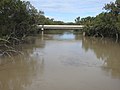
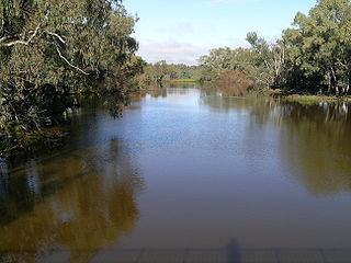
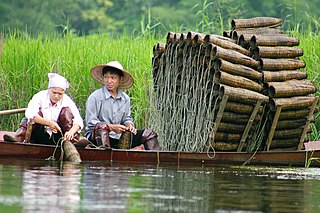
Brewarrina's most significant feature is its Aboriginal fish traps. Known in the local Aboriginal language as Baiame's Ngunnhu. It is believed that Ngemba, Wonkamurra, Wailwan and Gomolaroi people have shared and maintained the traps for thousands of years. The age of the fish traps is currently unknown, but they may be the oldest human construction in the world.[4] Locals claim that the traps are at least 40,000 years old and thus the oldest surviving human-made structure in the world.[24]
Consisting of river stones arranged to form small channels, the traps direct fish into small areas from which they are readily plucked. The traps form a complex net of linked weirs and ponds along 500m of the river. They operate at varying water heights and can be altered to suit seasonal changes. People use their expert knowledge of fish species and the environment to maximise their catch.[4][25][26] Brewarrina Ngemba Billabong has been declared a World Conservation Union (IUCN) Category V and VI protected area. It was declared an Indigenous Protected Area in November 2010.[18] The ready availability of fish made Brewarrina one of the great intertribal meeting places of pre-European eastern Australia.[24]
Climate
Brewarrina has the typical hot semi-arid climate of north-western New South Wales, with hot summers frequently over 40°C (104°F), cool winters and generally dry all year round. Brewarrina's highest recorded temperature was 48.9°C (120.0°F) on 19 December 1912, whilst its coldest was −4.1°C (24.6°F) on 14 July 1997. The average annual rainfall is 412.2mm (16.2in).[27]
The townspeople of Brewarrina play a variety of sports. The town has a local rugby union club and team, the Brewarrina Brumbies, and a number of rugby league teams. Local players Alby Carr, Ron Gibbs, Les Biles, Isaac Gordon and cousin Ashley Gordon played first grade in the National Rugby League. Netball is played weekly, with over 12 teams playing in the local competition. The Brewarrina Golf Club is renowned throughout the western region as one of the best 'oiled' green golf courses. Other major sports include lawn bowls, shooting, tennis and swimming. The river is also used for swimming and water skiing in the summer months. A skate park is near the town centre.
The Brewarrina Circus Skills Training Project is a 2004 program, which trains local kids skills in circus acts and gives them the opportunity to travel across the country to places like Adelaide and Melbourne.[30] The Brewarrina Youth Circus was a partnership with the Brewarrina Council and Brewarrina Central School with objectives to increase school attendance. This program has also given particular kids the chance to travel overseas, with one girl travelling to South Africa to perform in the art of circus skills.[31]
Events
Brewarrina plays host to one of the most famous rodeos in the far west of New South Wales. The Brewarrina Show and Rodeo Society runs a successful annual rodeo program which attracts a large crowd to town. Unfortunately over the last number of years, the Brewarrina Show has not been held.[32][when?]
The Brewarrina Races are an important race meet in the district hosted by the Brewarrina Jockey Club. The race meet is usually held in May and has a large prize pool, complete with an extensive race program, fashions on the field, as well as other novelty races and lucky door prizes.[33]
In more recent years,[when?] Brewarrina has played host to the Brewarrina Field Day, which came about as an event for people from the district to have a day out in the time after devastating drought. It showcases over 70 stalls, wildlife and agricultural exhibits, quick shear competitions, carnival rides, dog jumping trials, as well as food and bar stalls.[34]
The Bre Big Fish is an annual fishing competition run over the June public holiday long weekend. It is hosted by the Brewarrina Fishing Club and draws many fishing, hunting and camping enthusiasts to the district.[35]
In bygone years,[when?] Brewarrina was well renowned for its annual "Festival of the Fisheries", which celebrated Brewarrina's Aboriginal and European History. Brewarrina also hosted the unique "Surfboat Classic", which attracted a number of Surf Life Saving Clubs from the New South Wales Coast. Unfortunately these events have not been held in recent years.[36]
In April 2013, Brewarrina celebrated the 150th year since it was gazetted as a town in 1863. This was celebrated by a week long festival which included: Brewarrina Race Club meeting with over 2000 attendees, Bre Big Fish Competition, street parade and carnival, film festival, historical exhibitions, black tie ball, fireworks display, flower and cake show, as well as a number of celebratory sporting fixtures including rugby league and rugby union exhibition matches, clay target shooting and bowling competition.[37]
Notable citizens
Jimmie Barker, first Indigenous published author.[38]The two worlds of Jimmie Barker: The life of an Australian Aboriginal, 1900-1972 / as told to Janet Mathews.[39]
Mervyn Bishop (1945–), news and documentary photographer.[40] Mervyn won 'News photographer of the Year Award' for Life and Death Dash, the 1971 front page of the Sydney Morning Herald.[41]
Essie Coffey (1941–1998), community worker, singer, actor and film maker.[42] Co-founder of the Western Aboriginal Legal Service.
Ron Gibbs (1962–), 1980s/1990s Australian rugby league footballer.
Ashley Gordon, 1990s Australian rugby league footballer.
Isaac Gordon (1986–), 2010s Australian rugby league footballer.
Leo Schofield (1935–), restaurant critic, advertising professional and arts festival director.[43]
Albert George Henry Why (1899–1969), known as Alby Carr, an Australian rugby league footballer.
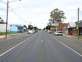
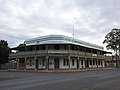
Bathurst Street main street, Hotel Brewarrina on the right (2008).
Bathurst Street, looking south-west (2021).
Anglican Christ Church, Young Street (2021).
Saint Patrick's Catholic Church (2021).
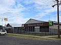
Hotel Brewarrina public hotel (2021).
Royal Hotel public hotel (2021).
Brewarrina Aboriginal Medical Service centre, Sandon Street, intersecting Bourke Street (2021).
Hospital (2021).
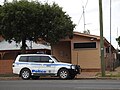
Court house (2021).
Australia Post office (2021).
NSW Police Force station (2021).
Fire station (2021).
Country Women's Association rest room (2021).
Returned and Services League hall (2021).
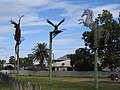
Art work in town park on Bridge Street (2021).
Related Research Articles
The Darling River is the third longest river in Australia, measuring 1,472 kilometres (915 mi) from its source in northern New South Wales to its confluence with the Murray River at Wentworth, New South Wales. Including its longest contiguous tributaries it is 2,844 km (1,767 mi) long, making it the longest river system in Australia.
Cobar is a town in central western New South Wales, Australia whose economy is based mainly upon base metals and gold mining. The town is 712 km (442 mi) by road northwest of the state capital, Sydney. It is at the crossroads of the Kidman Way and Barrier Highway. The town and the local government area, the Cobar Shire, are on the eastern edge of the outback. At the 2016 census, the town of Cobar had a population of 3,990. The Shire has a population of approximately 4,700 and an area of 44,065 square kilometres (17,014 sq mi).
Bogan River, a perennial river that is part of the Macquarie–Barwon catchment within the Murray–Darling basin, is located in the central west and Orana regions of New South Wales, Australia.
Bourke is a town in the north-west of New South Wales, Australia. The administrative centre and largest town in Bourke Shire, Bourke is approximately 800 kilometres (500 mi) north-west of the state capital, Sydney, on the south bank of the Darling River.
Barwon River, a perennial river that is part of the Murray–Darling basin, is located in the north-west slopes and Orana regions of New South Wales, Australia.
Walgett is a town in northern New South Wales, Australia, and the seat of Walgett Shire. It is near the junctions of the Barwon and Namoi Rivers and the Kamilaroi and Castlereagh Highways. In 2016, Walgett had a population of 2,145.
The Kamilaroi Highway is a 605-kilometre (376 mi) state highway located in the north-western region of New South Wales, Australia. The highway's northwestern terminus is at a junction with the Mitchell Highway at Bourke. Its southeastern terminus is a junction with the New England Highway north of Willow Tree.
Collarenebri is a town in north western New South Wales, Australia. The town is in the Walgett Shire Local Government Area and is situated on the Barwon River approximately 75 kilometres (47 mi) northeast of Walgett and south west of Mungindi on the Gwydir Highway. It is 16 km (9.9 mi) from Pokataroo which was the nearest railway town prior to closure of the rail service there. The town is 150 metres (490 ft) above sea level. Collarenebri is one of two towns ending in 'BRI' in Northern New South Wales.
Yetta Dhinnakkal Centre, also known as the Brewarrina Centre, was an Australian minimum security prison for young Indigenous Australian men. It was located in Gongolgon, approximately 70 kilometres (43 mi) south of Brewarrina, New South Wales. The centre was operated by Corrective Services NSW, an agency of the Department of Attorney General and Justice, of the Government of New South Wales, until its closure in mid-2020. Many of its inmates were first offenders, and the centre offered various types of educational opportunities, in particular farming skills.
Barwon is an electoral district of the Legislative Assembly in the Australian state of New South Wales. It is represented by Roy Butler of the Shooters Fishers and Farmers Party.
A fish trap is a trap used for fishing. Fish traps can have the form of a fishing weir or a lobster trap. Some fishing nets are also called fish traps, for example fyke nets.
Byrock is a small village in north western New South Wales, Australia in Bourke Shire. In 2016, Byrock had a population of 50 people.
Walgett Shire is a local government area in the Orana region of New South Wales, Australia. The northern boundary of the Shire is located adjacent to the border between New South Wales and Queensland. The town of Walgett is located on the Namoi River, nearby to its junction with the Barwon River and at the junction of the Kamilaroi Highway and the Castlereagh Highway.
Brewarrina Shire is a local government area in the Orana region of New South Wales, Australia. The Shire is located adjacent to the Darling River, which is known as the Barwon River upstream from Bourke; and located adjacent to the Kamilaroi Highway. The northern boundary of the Shire is located adjacent to the border between New South Wales and Queensland. The Shire is a wool and cotton growing area.
The Moonie River is a river in Shire of Balonne, Queensland and Walgett Shire, New South Wales, both in Australia. It is a perennial river of the Barwon catchment within the Murray–Darling basin.
The Hospital Creek Massacre refers to a retaliatory mass-slaughter of Indigenous Australians in 1859 in rural New South Wales. There are differing accounts of this event, but one alleges that a white stockman at Walcha Hut, abducted an Aboriginal woman. The stockman was warned by the woman's fellow tribe members to release her. When the stockman refused to release the woman, they were both killed. White settlers retaliated by shooting a large number of Aboriginal men, women and children. Another version claims that the Hospital Creek Massacre refers to the death of 300 Aboriginals in retaliation for having "annoyed" white settlers. Yet another version states that when a stockman went missing, it was assumed that Aboriginals were the culprits, and approximately 400 of them were rounded up and massacred in retaliation.
Brewarrina Aboriginal Fish Traps are heritage-listed Australian Aboriginal fish traps on the Barwon River at Brewarrina, Brewarrina Shire, New South Wales, Australia. They are also known as Baiame's Ngunnhu, Nonah, or Nyemba Fish Traps. The Brewarrina Aboriginal Cultural Museum, opened in 1988, adjoins the site. The fish traps were added to the New South Wales State Heritage Register on 11 August 2000 and to the Australian National Heritage List on 3 June 2005.
The Weilwan are an Aboriginal Australian people of the state of New South Wales. They are a clan of the Ngiyampaa nation.
The Ngiyampaa, also known as the Ngemba, are an Aboriginal Australian people of the state of New South Wales. The generic name refers to an aggregation of three groups, the Ngiyampaa, the Ngiyampaa Wangaaypuwan, and the Ngiyampaa Weilwan, respectively clans of a larger Ngiyampaa nation.
Brewarrina Aboriginal Mission Site is a heritage-listed site of the former mission station for Aboriginal Australians and cemetery at The Old Mission Road, Brewarrina, Brewarrina Shire, New South Wales, Australia. It was also known as Barwon Mission, Brewarrina Mission and Brewarrina Aboriginal Station. Built from 1880, it was added to the New South Wales State Heritage Register on 21 July 2006.
1 2 3 Office of Environment and Heritage. "Brewarrina Aboriginal Fish Traps / Baiame's Ngunnhu". In one recorded incident in 1859 a stockman at Walcha Hut on the Lawson run was warned by Aborigines to release one of their women. He refused, and both he and the woman were killed. In retaliation, the settlers shot a large number of Aboriginal men, women and children in what became known as the Hospital Creek Massacre (Rando, 2007, p38). NSW Government. Archived from the original on 22 December 2015. Retrieved 19 December 2015.
↑ "Last of the Culgoa Blacks". The Farmer and Settler. I (50). New South Wales, Australia. 24 October 1911. p.5. Archived from the original on 17 April 2018. Retrieved 17 April 2018– via National Library of Australia.
↑ "Archived copy". Archived from the original on 17 August 2018. Retrieved 17 August 2018.CS1 maint: archived copy as title (link)
↑ "Brewarrina". The most prominent building in the town is the Brewarrina Court House. It was built in 1871-72 and is a fine example of the colonial architecture of the time. Phoenix Group. Archived from the original on 12 December 2013. Retrieved 10 December 2013.
↑ Andrew Pike and Ross Cooper, Australian Film 1900–1977: A Guide to Feature Film Production, Melbourne: Oxford University Press, 1998, 21
1 2 "Brewarrina Ngemba Billabong". Department of the Environment. Australian Government. Archived from the original on 22 December 2015. Retrieved 19 December 2015.
↑ Boney, Brooke (1 August 2016). "What justice reinvestment can do for juvenile offenders". Nestled in besides the banks of the Barwon River in north-western New South Wales is the tiny town of Brewarrina. The 1,200 or so locals call it Bre. On Old Mission Road on the outskirts of town sits the first site ever established by the state government to segregate Aboriginal people from the rest of the town. ABC. Archived from the original on 2 February 2017. Retrieved 26 January 2017.
↑ "Bush Queen of Brewarrina". Martyrs in The Struggle for Justice. The Koori History Website. Archived from the original on 22 August 2011. Retrieved 12 July 2015.
This page is based on this Wikipedia article Text is available under the CC BY-SA 4.0 license; additional terms may apply. Images, videos and audio are available under their respective licenses.