Denison County

Last updated

Map all coordinates using: OpenStreetMap  
Download coordinates as: KML  ·  GPX
Denison
New South Wales
Denison NSW.PNG
Location in New South Wales
Lands administrative divisions around Denison:
Townsend Urana Urana
Townsend Denison Hume
Moira (Vic) Moira (Vic) Bogong (Vic)

Denison County is one of the 141 Cadastral divisions of New South Wales. It contains the towns of Barooga and Berrigan.

Berrigan, New South Wales Town in New South Wales, Australia

Berrigan is a town on the Riverina Highway in the Riverina region of New South Wales, Australia. Berrigan is in the Berrigan Shire local government area and contains the Berrigan Shire Council offices. At the 2016 census, Berrigan had a population of 1,260.

Denison County was named in honour of the Governor-General of New South Wales, Sir William Thomas Denison (1804-1871). [1]

Parishes within this county

Denison County NSW as shown on John Sands 1886 map) Denison County NSW John Sands Map (B&W).png
Denison County NSW as shown on John Sands 1886 map)

A full list of parishes found within this county; their current LGA and mapping coordinates to the approximate centre of each location is as follows:

Local government in Australia

Local government in Australia is the third tier of government in Australia administered by the states and territories, which in turn are beneath the federal tier. Local government is not mentioned in the Constitution of Australia and two referenda in the 1970s and 1980s to alter the Constitution relating to local government were unsuccessful. Every state government recognises local government in their respective constitutions. Unlike Canada or the United States, there is only one level of local government in each state, with no distinction such as cities and counties.

ParishLGACoordinates
Barooga Berrigan Shire Council 35°49′54″S145°40′04″E / 35.83167°S 145.66778°E / -35.83167; 145.66778 (Barooga)
Berrigan Berrigan Shire Council 35°33′54″S145°44′04″E / 35.56500°S 145.73444°E / -35.56500; 145.73444 (Berrigan)
Boomanoomana Berrigan Shire Council 35°54′54″S145°54′04″E / 35.91500°S 145.90111°E / -35.91500; 145.90111 (Boomanoomana)
Bull Plain Federation Council 35°44′54″S146°10′04″E / 35.74833°S 146.16778°E / -35.74833; 146.16778 (Bull Plain)
Carlyle Berrigan Shire Council 35°49′54″S145°54′04″E / 35.83167°S 145.90111°E / -35.83167; 145.90111 (Carlyle)
Coreen West Federation Council 35°38′54″S146°14′04″E / 35.64833°S 146.23444°E / -35.64833; 146.23444 (Coreen West)
Cottadidda Berrigan Shire Council 35°54′54″S145°45′04″E / 35.91500°S 145.75111°E / -35.91500; 145.75111 (Cottadidda)
Denison Federation Council 35°47′54″S146°09′04″E / 35.79833°S 146.15111°E / -35.79833; 146.15111 (Denison)
Dry Forest Federation Council 30°52′54″S146°10′04″E / 30.88167°S 146.16778°E / -30.88167; 146.16778 (Dry Forest)
Finley Berrigan Shire Council 35°38′54″S145°36′04″E / 35.64833°S 145.60111°E / -35.64833; 145.60111 (Finley)
Gereldery Berrigan Shire Council 35°41′54″S145°49′04″E / 35.69833°S 145.81778°E / -35.69833; 145.81778 (Gereldery)
Headford Berrigan Shire Council 35°44′54″S145°42′04″E / 35.74833°S 145.70111°E / -35.74833; 145.70111 (Headford)
Kilnyana Berrigan Shire Council 35°45′54″S145°55′04″E / 35.76500°S 145.91778°E / -35.76500; 145.91778 (Kilnyana)
Lalalty Berrigan Shire Council 35°50′54″S145°46′04″E / 35.84833°S 145.76778°E / -35.84833; 145.76778 (Lalalty)
Langunya Berrigan Shire Council 35°43′54″S145°36′04″E / 35.73167°S 145.60111°E / -35.73167; 145.60111 (Langunya)
Momolong Federation Council 35°35′54″S146°00′04″E / 35.59833°S 146.00111°E / -35.59833; 146.00111 (Momolong)
Mulwala Federation Council 35°55′54″S146°01′04″E / 35.93167°S 146.01778°E / -35.93167; 146.01778 (Mulwala)
Nangunia Berrigan Shire Council 35°45′54″S145°48′04″E / 35.76500°S 145.80111°E / -35.76500; 145.80111 (Nangunia)
Narrow Plains Federation Council 35°37′54″S146°04′04″E / 35.63167°S 146.06778°E / -35.63167; 146.06778 (Narrow Plains)
Osborne Berrigan Shire Council 35°36′54″S145°50′04″E / 35.61500°S 145.83444°E / -35.61500; 145.83444 (Osborne)
Sargood Berrigan Shire Council 35°32′54″S145°38′04″E / 35.54833°S 145.63444°E / -35.54833; 145.63444 (Sargood)
Savernake Federation Council 35°45′54″S146°01′04″E / 35.76500°S 146.01778°E / -35.76500; 146.01778 (Savernake)
Tocumwal Berrigan Shire Council 35°46′54″S145°33′04″E / 35.78167°S 145.55111°E / -35.78167; 145.55111 (Tocumwal)
Tongaboo Berrigan Shire Council 35°32′54″S145°34′04″E / 35.54833°S 145.56778°E / -35.54833; 145.56778 (Tongaboo)
Turramia Federation Council 35°56′54″S146°07′04″E / 35.94833°S 146.11778°E / -35.94833; 146.11778 (Turramia)
Ulupna Berrigan Shire Council 35°37′54″S145°33′04″E / 35.63167°S 145.55111°E / -35.63167; 145.55111 (Ulupna)
Wahgunyah Federation Council 35°50′54″S146°02′04″E / 35.84833°S 146.03444°E / -35.84833; 146.03444 (Wahgunyah)
Wangamong Federation Council 35°37′54″S146°08′04″E / 35.63167°S 146.13444°E / -35.63167; 146.13444 (Wangamong)
Warmatta Berrigan Shire Council 35°41′54″S145°55′04″E / 35.69833°S 145.91778°E / -35.69833; 145.91778 (Warmatta)
Warragubogra Berrigan Shire Council 35°38′54″S145°42′04″E / 35.64833°S 145.70111°E / -35.64833; 145.70111 (Warragubogra)
Woperana Berrigan Shire Council 35°41′54″S145°30′04″E / 35.69833°S 145.50111°E / -35.69833; 145.50111 (Woperana)

Related Research Articles

Denison, Texas City in Texas, United States

Denison is a city in Grayson County, Texas, United States. It is 75 miles (121 km) north of Dallas. The population was 22,682 at the 2010 census. Denison is part of the Texoma region and is one of two principal cities in the Sherman–Denison Metropolitan Statistical Area. Denison is known as the birthplace of Dwight D. Eisenhower, the 34th President of the United States.

Sherman, Texas City in Texas, United States

Sherman is a U.S. city in and the county seat of Grayson County, Texas. The city's population in 2010 was 38,521. It is one of the two principal cities in the Sherman–Denison Metropolitan Statistical Area, and it is part of the Texoma region of North Texas and southern Oklahoma.

Van Alstyne, Texas City in Texas, United States

Van Alstyne is a city in Grayson and Collin Counties in the U.S. state of Texas. The population was 3,046 at the 2010 census, up from 2,502 at the 2000 census. The Grayson County portion of Van Alstyne is part of the Sherman–Denison Metropolitan Statistical Area.

Port Jackson Part of Sydney Harbour, Australia

Port Jackson, consisting of the waters of Sydney Harbour, Middle Harbour, North Harbour and the Lane Cove and Parramatta Rivers, is the ria or natural harbour of Sydney, New South Wales, Australia. The harbour is an inlet of the Tasman Sea. It is the location of the Sydney Opera House and Sydney Harbour Bridge. The location of the first European settlement and colony on the Australian mainland, Port Jackson has continued to play a key role in the history and development of Sydney.
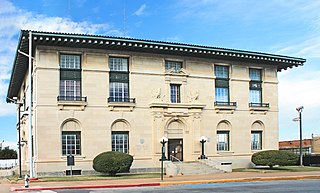
Fort Denison Old fort in the Sydney Harbour National Park

Building details

The Geographical Names Board of New South Wales, a statutory authority of the Land and Property Information division, Department of Finance and Services in the Government of New South Wales, is the official body for naming and recording details of places and geographical names in the state of New South Wales, Australia.

William Denison British colonial administrator

Sir William Thomas Denison was Lieutenant Governor of Van Diemen's Land from 1847 to 1855, Governor of New South Wales from 1855 to 1861, and Governor of Madras from 1861 to 1866.

Division of Denison (state) state electoral division of Tasmania, Australia

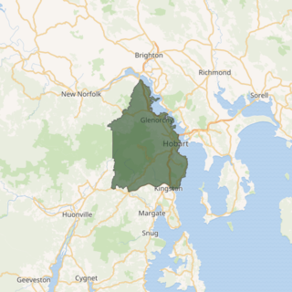
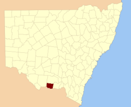
The electoral division of Denison was an electorate of the Tasmanian House of Assembly from 1909 to 2018. It was located in Hobart on the western shore of the River Derwent and includes the suburbs below Mount Wellington. Denison was named after Sir William Denison, who was Lieutenant Governor of Van Diemen's Land (1847–55), and Governor of New South Wales (1855–61). The electorate shared its name and boundaries with the federal division of Denison. The seat was abolished in September 2018 and replaced by the Division of Clark, in line with its federal namesake.

Darbalara, New South Wales Town in New South Wales, Australia

Darbalara is a rural community on the east bank of the junction of the Murrumbidgee River and Tumut River in the Riverina. It is situated by road, about 25 kilometres north east of Gundagai and 25 kilometres south of Coolac.

Gloucester County, New South Wales Cadastral in New South Wales, Australia

Gloucester County was one of the original Nineteen Counties in New South Wales, and is now one of the 141 cadastral divisions of New South Wales. It includes the area around Port Stephens. It is bounded on the north and west by the Manning River, and on the south-west by the Williams River.

Bathurst High Campus

The Bathurst High Campus of Denison College of Secondary Education is a government-funded co-educational comprehensive secondary day school campus, located in Bathurst, in the Central West region of New South Wales, Australia.

Cowper County Cadastral in New South Wales, Australia

Cowper County, New South Wales is one of the 141 Cadastral divisions of New South Wales.

Pyrmont was an electoral district of the Legislative Assembly in the Australian state of New South Wales, created in 1904, replacing Sydney-Pyrmont and part of Sydney-Denison. It was abolished in 1913.

Sydney-Denison was an electoral district of the Legislative Assembly in the Australian state of New South Wales, created in 1894 from part of the electoral district of West Sydney in the Ultimo area and named after Governor Denison. It was abolished in 1904 and absorbed into the electoral district of Pyrmont.

Denison College of Secondary Education

Denison College of Secondary Education is a dual-campus government-funded co-educational comprehensive secondary day school, located in Bathurst, in the Central West region of New South Wales, Australia.

Kelso High Campus

The Kelso High Campus of Denison College of Secondary Education is a government-funded co-educational comprehensive secondary day school campus, located in Kelso, in the Central West region of New South Wales, Australia.

Denison Bridge

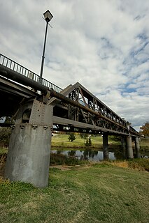
The Denison Bridge is a heritage-listed footbridge over the Macquarie River in Bathurst, New South Wales, Australia. It is the fourth oldest metal truss bridge existing in Australia.

Denison Town, New South Wales Town in New South Wales, Australia

Denison Town is a ghost town in New South Wales, Australia. It was established in the 1850s and is thought to have been named after the Governor of New South Wales, Sir William Thomas Denison. It was located about 11 kilometres (7 mi) from the present town of Dunedoo. In its heyday, Denison Town consisted of an inn, post office, church and cemetery, and was the occasional venue for sittings of the Local Court. Local industries included the farming of wheat, sheep and cattle, alongside sporadic prospecting for silver ore.

Fort Denison Light Lighthouse in New South Wales, Australia

Fort Denison Light, also known as Pinchgut Light, is an active lighthouse located on top of a Martello Tower at Fort Denison, a former penal site and defensive facility occupying a small island in Sydney Harbour, New South Wales, Australia. The island is located downstream from the Harbour Bridge near Potts Point and the Royal Botanic Gardens. The fort is also known as "Pinchgut" lending its name to the light.

The 1859 New South Wales colonial election was held between 9 June and 7 July 1859. This election was for all of the 80 seats in the New South Wales Legislative Assembly and it was conducted in 58 single-member constituencies, seven 2-member constituencies and two 4-member constituencies, all with a first past the post system. Suffrage was limited to adult white males. The previous parliament of New South Wales was dissolved on 11 April 1859 by the Governor, Sir William Denison, on the advice of the Premier, Charles Cowper.

References

  1. "Denison". Geographical Names Register (GNR) of NSW. Geographical Names Board of New South Wales . Retrieved 4 August 2013. OOjs UI icon edit-ltr-progressive.svg
  2. The New atlas of Australia (John Sands 1886) map 21.