Tongowoko County

Last updated

Map all coordinates using: OpenStreetMap  
Download coordinates as: KML
Tongowoko
New South Wales
Tongowoko NSW.PNG
Location in New South Wales
Lands administrative divisions around Tongowoko:
Queensland Queensland Queensland
Poole Tongowoko Delalah
Evelyn Yantara Yantara

Tongowoko County is one of the 141 Cadastral divisions of New South Wales. It is located in the remote north-west of the state, south of the Queensland border.

Contents

The name Tongowoko is believed to be derived from a local Aboriginal word. [1]

Parishes within this county

A full list of parishes found within this county; their current LGA and mapping coordinates to the approximate centre of each location is as follows:

ParishLGACoordinates
Binaroo Unincorporated 29°23′50″S142°20′04″E / 29.39722°S 142.33444°E / -29.39722; 142.33444 (Binaroo)
Bolwarry Unincorporated 29°26′39″S142°30′25″E / 29.44417°S 142.50694°E / -29.44417; 142.50694 (Bolwarry)
Calathunda Unincorporated 29°17′01″S142°37′25″E / 29.28361°S 142.62361°E / -29.28361; 142.62361 (Calathunda)
Caryapundy Unincorporated 29°02′34″S142°38′57″E / 29.04278°S 142.64917°E / -29.04278; 142.64917 (Caryapundy)
Churriga [2] Unincorporated
Connulpie Unincorporated

29°15′03″S142°32′49″E / 29.25083°S 142.54694°E / -29.25083; 142.54694 (Connulpie)

Hermitage Unincorporated 29°22′57″S142°01′09″E / 29.38250°S 142.01917°E / -29.38250; 142.01917 (Hermitage)
Koonyaboothie Unincorporated 29°36′59″S142°23′17″E / 29.61639°S 142.38806°E / -29.61639; 142.38806 (Koonyaboothie)
Kurawillia Unincorporated 29°36′59″S142°34′32″E / 29.61639°S 142.57556°E / -29.61639; 142.57556 (Kurawillia)
Mokely [3] Unincorporated
Mount Stuart Unincorporated 29°30′32″S142°01′08″E / 29.50889°S 142.01889°E / -29.50889; 142.01889 (Mount Stuart)
Mount Wood Unincorporated 29°16′58″S142°17′37″E / 29.28278°S 142.29361°E / -29.28278; 142.29361 (Mount Wood)
Olive Unincorporated 29°02′40″S141°52′14″E / 29.04444°S 141.87056°E / -29.04444; 141.87056 (Olive)
Silva Unincorporated 29°07′49″S142°21′47″E / 29.13028°S 142.36306°E / -29.13028; 142.36306 (Silva)
Tooncurrie Unincorporated 29°31′44″S142°13′52″E / 29.52889°S 142.23111°E / -29.52889; 142.23111 (Tooncurrie)
Tongowoko Unincorporated
Torrens Unincorporated 29°14′00″S142°09′27″E / 29.23333°S 142.15750°E / -29.23333; 142.15750 (Torrens)
Wanpah Unincorporated 29°07′48″S142°10′52″E / 29.13000°S 142.18111°E / -29.13000; 142.18111 (Wanpah)
Warratta Unincorporated 29°34′54″S141°51′08″E / 29.58167°S 141.85222°E / -29.58167; 141.85222 (Warratta)
Warri Unincorporated 29°02′09″S141°57′55″E / 29.03583°S 141.96528°E / -29.03583; 141.96528 (Warri)
Whittabranah Unincorporated 29°12′31″S142°01′10″E / 29.20861°S 142.01944°E / -29.20861; 142.01944 (Whittabranah)
Yalpunga Unincorporated 29°02′40″S142°03′13″E / 29.04444°S 142.05361°E / -29.04444; 142.05361 (Yalpunga)
Yanderra Unincorporated 29°20′36″S142°34′55″E / 29.34333°S 142.58194°E / -29.34333; 142.58194 (Yandera)

From 2009, the parishes of Tongowoko lie within Division A of the Western Livestock Health and Pest District, [4] along with Evelyn, Farnell, Fitzgerald, Mootwingee, Poole, Tandora, Yantara, and Yungnulgra Counties; some parishes of Killara, Yancowinna, and Young; and with Connulpie and Omura Parishes of Delalah County.

Related Research Articles

The Surveyor-General of New South Wales is the primary government authority responsible for land and mining surveying in New South Wales.

<span class="mw-page-title-main">Delalah County</span> Cadastral in New South Wales, Australia

Delalah County is one of the 141 Cadastral divisions of New South Wales.

<span class="mw-page-title-main">Irrara County</span> Cadastral in New South Wales, Australia

Irrara County is one of the 141 Cadastral divisions of New South Wales. It is located south of the border with Queensland, east of the Paroo River, and west of the Warrego River.

<span class="mw-page-title-main">Poole County</span> Cadastral in New South Wales, Australia

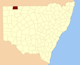
Poole County is one of the 141 Cadastral divisions of New South Wales. It is located in the extreme north-west of the state, abutting Cameron Corner. It includes parts of Sturt National Park.

<span class="mw-page-title-main">Hoskinstown</span> Town in New South Wales, Australia

Hoskinstown is a locality in Queanbeyan-Palerang Regional Council, New South Wales, Australia. The locality, and what remains of the cluster of settlement of the same name, is 38 km southeast of Canberra the Capital city of Australia, and 299 km southwest of Sydney. At the 2021 census, it had a population of 191.

<span class="mw-page-title-main">Parish of Allundy</span>

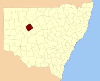
Allundy, New South Wales, located at 29°53′05″S 143°34′02″E, is a parish of Ularara County in north west New South Wales, Australia.

<span class="mw-page-title-main">Parish of Deriringa</span>

Deriringa is a Parish of Ularara County in north west New South Wales. It is between Milparinka, New South Wales and Wilcannia and west of Wanaaring. The main economic activity of the parish is agriculture, with the Ardoo and the Salisbury Downs Station. the parish is at 30°06′37″S 143°34′02″E.

<span class="mw-page-title-main">Parish of Buntiara</span>

Buntiara is a Parish of Ularara County in north west New South Wales. It is between Milparinka, New South Wales and Wilcannia and west of Wanaaring.

<span class="mw-page-title-main">Parish of Yambunya</span>

Yambunya is a parish of Ularara County in northwest New South Wales, Australia. It is between Milparinka and Wilcannia and west of Wanaaring.

<span class="mw-page-title-main">Parish of Hermitage</span> Town in New South Wales, Australia

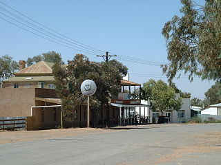
Hermitage, New South wales, is a civil parish of Tongowoko County, New South Wales. The town of Tibooburra is the only settlement in the parish.

<span class="mw-page-title-main">Parish of Whittabranah</span>

Whittabranah is a civil parish of Tongowoko County, New South Wales, Australia. The parish is 5 miles north of Tibooburra.

<span class="mw-page-title-main">Parish of Binaroo</span> Parish in New South Wales

Binaroo is a civil parish of Tongowoko County, New South wales. The parish is east of Tibooburra.

<span class="mw-page-title-main">Parish of Calathunda</span>

Calathunda is a remote civil parish of Tongowoko County, in New South Wales. The parish is north east of Tibooburra.

Torrens Parish, New South Wales located at 29°14′00″S 142°09′27″E is a rural locality in and a cadastral parish of Tongowoko County, two kilometers north east from the town of Tibooburra, New South Wales. The parish is north east of Tibooburra, within the Sturt National Park.

<span class="mw-page-title-main">Parish of Bolwarry</span>

Bolwarry, New South Wales is a civil parish of Tongowoko County, New South wales. The parish is east of Tibooburra.

<span class="mw-page-title-main">Parish of Donalroe</span>

Donalroe Parish in Cobar Shire is a civil parish of Rankin County,; a Cadastral division of New South Wales.

Cumbedore Parish, Yanda County in Bourke Shire is a civil parish of Yanda County, a cadasteral division of New South Wales; a Cadastral division of New South Wales.

Canpadore Parish, Yanda County in Bourke Shire is a civil parish of Yanda County, a cadasteral division of New South Wales; a Cadastral division of New South Wales.

<span class="mw-page-title-main">Dunlop Parish (Yanda County)</span> Place in New South Wales, Australia

Dunlop Parish is a civil parish, of Yanda County, a cadasteral division of New South Wales; a Cadastral division of New South Wales.

Gundabooka Parish is a civil parish, of Yanda County, a cadasteral division of New South Wales; a Cadastral division of New South Wales.

References

  1. "Tongowoko". Geographical Names Register (GNR) of NSW. Geographical Names Board of New South Wales . Retrieved 4 August 2013. OOjs UI icon edit-ltr-progressive.svg
  2. https://proposals.gnb.nsw.gov.au/public/geonames/6feb2783-8332-4827-bf97-a01cedc7fd30 [ bare URL ]
  3. https://proposals.gnb.nsw.gov.au/public/geonames/b3104bc3-8ddc-4a1d-a3d6-2391ba206619 [ bare URL ]
  4. "Rural Lands Protection Act 1998, Order – Section 6, Divisions of Western Livestock Health and Pest District" (PDF). N.S.W. Government Gazette (29): 760–787. Retrieved 29 September 2022.