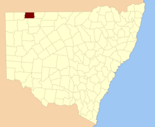
Irrara County is one of the 141 Cadastral divisions of New South Wales. It is located south of the border with Queensland, east of the Paroo River, and west of the Warrego River.

Tongowoko County is one of the 141 Cadastral divisions of New South Wales. It is located in the remote north-west of the state, south of the Queensland border.
Caryapundy Station most commonly known as Caryapundy or Caryapundy Swamp is a pastoral lease that once operated as a cattle station in the channel country of outback New South Wales.

Yalpunga located at 29°02′40″S 142°03′13″E is a civil parish of Tongowoko County, New South Wales.

Hermitage, New South wales, is a civil parish of Tongowoko County, New South Wales. The town of Tibooburra is the only settlement in the parish.

Whittabranah is a civil parish of Tongowoko County, New South Wales, Australia. The parish is 5 miles north of Tibooburra.

Binaroo is a civil parish of Tongowoko County, New South wales. The parish is east of Tibooburra.

Calathunda is a remote civil parish of Tongowoko County, in New South Wales. The parish is north east of Tibooburra.
Mount Stuart located at 29°30'32.0"S 142°01'08.0"E is a civil parish of Tongowoko County, on the opposite bank of the Thomson Creek from the town of Tibooburra. The parish is east of Tibooburra.
Torrens Parish, New South Wales located at 29°14′00″S 142°09′27″E is a rural locality in and a cadastral parish of Tongowoko County, two kilometers north east from the town of Tibooburra, New South Wales. The parish is north east of Tibooburra, within the Sturt National Park.

Olive, also known as Olive Downs, is a civil parish of Tongowoko County in far north west New South Wales, located at 29°02′40″S 141°52′14″E.

Koonyaboothie located between Pindera Downs Aboriginal Area and Tibooburra is a cadastral parish of Tongowoko County in New South Wales, Australia.

Bolwarry, New South Wales is a civil parish of Tongowoko County, New South wales. The parish is east of Tibooburra.
Silva located 29°07′49″S 142°21′47″ halfway between Bulloo Downs, Queensland, and Tibooburra, New South Wales, is a cadastral parish of Tongowoko County New South Wales.

Tooncurrie Parish located at 29°31′44″S 142°13′52″E just east of Tibooburra, New South Wales is a cadastral parish of Tongowoko County New South Wales. The town of Tibooburrais just outside the parish.

Yanderra parish is a cadastral parish of Tongowoko County New South Wales.

Wanpah Parish is a civil land parish of Tongowoko County, New South Wales.

Connulpie, New South Wales is a remote civil Parish, of the County of Delalah a cadasteral division of New South Wales.
Parish of Tongowoko may refer to either of two land parishes of New South Wales:

Tongowoko Parish is a civil land parish of Tongowoko County, New South Wales. It is bordered by the parishes of Silva, Connulpie, Calathunda, and Caryapundy.


