Delalah County

Last updated

Map all coordinates using: OpenStreetMap  
Download coordinates as: KML
Delalah
New South Wales
Delalah NSW.PNG
Location in New South Wales
Lands administrative divisions around Delalah:
Queensland Queensland Queensland
Tongowoko Delalah Thoulcanna
Yantara Ularara Ularara

Delalah County is one of the 141 Cadastral divisions of New South Wales.

Delalah is believed to be derived from a local Aboriginal word and is also the name of Delalah Downs property – within the county area. [1]

Parishes within this county

A map of Delilah County, NSW on the border with Queensland. Delilah County1.png
A map of Delilah County, NSW on the border with Queensland.

A full list of parishes found within this county; their current LGA and mapping coordinates to the approximate centre of each location is as follows:

ParishLGACoordinates
Albert Unincorporated 29°22′22″S142°57′41″E / 29.37278°S 142.96139°E / -29.37278; 142.96139 (Albert)
Berawinia Unincorporated 29°11′19″S143°34′56″E / 29.18861°S 143.58222°E / -29.18861; 143.58222 (Berawinia)
Border Unincorporated 29°07′01″S143°07′21″E / 29.11694°S 143.12250°E / -29.11694; 143.12250 (Border)
Bulloo Unincorporated 29°12′55″S142°47′29″E / 29.21528°S 142.79139°E / -29.21528; 142.79139 (Bulloo)
Caloola Unincorporated 29°02′07″S143°36′43″E / 29.03528°S 143.61194°E / -29.03528; 143.61194 (Caloola)
Catombal Unincorporated 29°19′11″S143°27′03″E / 29.31972°S 143.45083°E / -29.31972; 143.45083 (Catombal)
Connulpie Unincorporated 29°30′54″S142°44′00″E / 29.51500°S 142.73333°E / -29.51500; 142.73333 (Connulpie)
Corriwelpie Unincorporated 29°02′06″S142°46′42″E / 29.03500°S 142.77833°E / -29.03500; 142.77833 (Corriwelpie)
Cullamulcha Unincorporated 29°06′22″S143°17′24″E / 29.10611°S 143.29000°E / -29.10611; 143.29000 (Cullamulcha)
Delalah Unincorporated 29°14′37″S143°06′37″E / 29.24361°S 143.11028°E / -29.24361; 143.11028 (Delalah)
Delalah South Unincorporated 29°22′24″S143°07′01″E / 29.37333°S 143.11694°E / -29.37333; 143.11694 (Delalah South)
Downs Unincorporated 29°14′34″S142°56′42″E / 29.24278°S 142.94500°E / -29.24278; 142.94500 (Downs)
Elsinora Unincorporated 29°26′38″S143°32′58″E / 29.44389°S 143.54944°E / -29.44389; 143.54944 (Elsinora)
Killen Unincorporated 29°15′11″S143°17′26″E / 29.25306°S 143.29056°E / -29.25306; 143.29056 (Killen)
Korri Unincorporated 29°07′10″S142°55′48″E / 29.11944°S 142.93000°E / -29.11944; 142.93000 (Korri)
Nocotunga Unincorporated 29°28′49″S143°23′33″E / 29.48028°S 143.39250°E / -29.48028; 143.39250 (Nocotunga)
Omura Unincorporated 29°30′58″S142°53′59″E / 29.51611°S 142.89972°E / -29.51611; 142.89972 (Omura)
Osaca Unincorporated 29°26′36″S143°14′58″E / 29.44333°S 143.24944°E / -29.44333; 143.24944 (Osaca)
Thoulcanna Unincorporated 29°02′06″S143°27′19″E / 29.03500°S 143.45528°E / -29.03500; 143.45528 (Thoulcanna)
Thurlow Unincorporated 29°10′46″S143°27′21″E / 29.17944°S 143.45583°E / -29.17944; 143.45583 (Thurlow)
Tongowoko Unincorporated 29°21′52″S142°48′04″E / 29.36444°S 142.80111°E / -29.36444; 142.80111 (Tongowoko)
Tooma Unincorporated 29°22′40″S143°17′16″E / 29.37778°S 143.28778°E / -29.37778; 143.28778 (Tooma)
Urella Unincorporated 29°26′34″S143°04′10″E / 29.44278°S 143.06944°E / -29.44278; 143.06944 (Urella)

From 2009, the parishes of Delalah lie within District H of the Darling Livestock Health and Pest District. [2]

Related Research Articles

<span class="mw-page-title-main">Lands administrative divisions of New South Wales</span>

For lands administrative purposes, New South Wales is divided into 141 counties, which are further divided into parishes. The counties were first set down in the Colony of New South Wales, which later became the Australian state of New South Wales.

<span class="mw-page-title-main">Cowper County</span> Cadastral in New South Wales, Australia

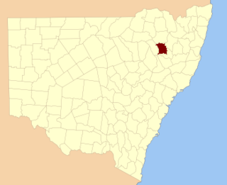
Cowper County, New South Wales is one of the 141 Cadastral divisions of New South Wales.

<span class="mw-page-title-main">Darling County</span> Cadastral in New South Wales, Australia

Darling County is one of the 141 Cadastral divisions of New South Wales. It includes Manilla and Barraba

<span class="mw-page-title-main">Gunderbooka County</span> Cadastral in New South Wales, Australia

Gunderbooka County is one of the 141 Cadastral divisions of New South Wales. The Warrego River is the western boundary, and the Culgoa River and Darling River is the south-eastern boundary. It includes the area down to where the Warrego meets the Darling, to the north of Bourke.

<span class="mw-page-title-main">Irrara County</span> Cadastral in New South Wales, Australia

Irrara County is one of the 141 Cadastral divisions of New South Wales. It is located south of the border with Queensland, east of the Paroo River, and west of the Warrego River.

<span class="mw-page-title-main">Killara County</span> Cadastral in New South Wales, Australia

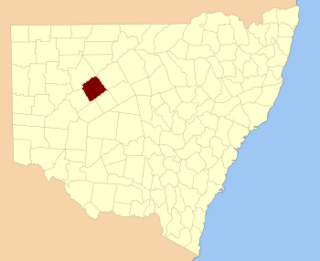
Killara County is one of the 141 Cadastral divisions of New South Wales. The Darling River is its south eastern boundary.

<span class="mw-page-title-main">Rankin County, New South Wales</span> Cadastral in New South Wales, Australia

Rankin County is one of the 141 Cadastral divisions of New South Wales. It includes part of the Paroo-Darling National Park. The border to the north-west is the Darling River.

<span class="mw-page-title-main">Tongowoko County</span> Cadastral in New South Wales, Australia

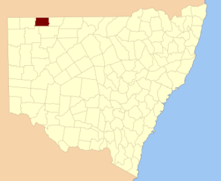
Tongowoko County is one of the 141 Cadastral divisions of New South Wales. It is located in the remote north-west of the state, south of the Queensland border.

<span class="mw-page-title-main">Wentworth County</span> Cadastral in New South Wales, Australia

Wentworth County is one of the 141 Cadastral divisions of New South Wales. The Murray River is the boundary to the south, and the Anabranch of the Darling River is the western boundary. It includes the area where the Darling River joins the Murray River.

<span class="mw-page-title-main">Cobrabald River</span> River in New South Wales, Australia

Cobrabald River, a mostly perennial river that is part of the Namoi catchment within the Murray–Darling basin, is located in the Northern Tablelands district of New South Wales, Australia.

<span class="mw-page-title-main">Dunlop Parish (Yanda County)</span> Place in New South Wales, Australia

Dunlop Parish is a civil parish, of Yanda County, a cadasteral division of New South Wales; a Cadastral division of New South Wales.

<span class="mw-page-title-main">Parish of Korri</span>

Korri Parish is a remote civil Parish, of the County of Delalah a cadasteral division of New South Wales.

<span class="mw-page-title-main">Parish of Cullamulcha</span>

Cullamulcha, New South Wales is a civil Parish, of the County of Delalah, a cadasteral division of New South Wales.

<span class="mw-page-title-main">Parish of Thoulcanna</span>

Thoulcanna, New South Wales is a remote civil Parish, of the County of Delalah, a cadasteral division of New South Wales.

<span class="mw-page-title-main">Parish of Killen</span>

Killen, New South Wales is a civil Parish, of the County of Delalah, a cadasteral division of New South Wales.

<span class="mw-page-title-main">Parish of Berawinia</span>

Berawinia, New South Wales is a remote civil Parish, of the County of Delalah, a cadasteral division of New South Wales.

<span class="mw-page-title-main">Parish of Elsinora</span>

Elsinora, in New South Wales, Australia, is a civil parish of the county of Delalah, a cadasteral division of New South Wales.

<span class="mw-page-title-main">Parish of Connulpie</span> Local government in Australia

Connulpie, New South Wales is a remote civil Parish, of the County of Delalah a cadasteral division of New South Wales.

<span class="mw-page-title-main">Parish of Delalah</span>

Delalah Parish is a remote civil Parish, of the County of Delalah a cadasteral division of New South Wales.

<span class="mw-page-title-main">Kerrininna, New South Wales</span>

Kerrininna, New South Wales is a remote rural locality and civil Parish, of the Thoulcanna County a cadasteral division of New South Wales. Kerrininna Parish is on the Paroo River south of Hungerford, Queensland.

References

  1. "Delalah". Geographical Names Register (GNR) of NSW. Geographical Names Board of New South Wales . Retrieved 4 August 2013. OOjs UI icon edit-ltr-progressive.svg
  2. "Rural Lands Protection Act 1998, Order – Section 6, Divisions of Darling Livestock Health and Pest District" (PDF). N.S.W. Government Gazette (29): 643–662. Retrieved 29 September 2022. Division H begins on p. 659.