
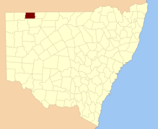
Connulpie, New South Wales is a remote civil Parish, of the County of Delalah [1] a cadasteral division of New South Wales. [2]
Connulpie, New South Wales is a remote civil Parish, of the County of Delalah [1] a cadasteral division of New South Wales. [2]
The topography of Connulpie, is the flat arid landscape of the Channel County with a Köppen climate classification of BWh (Hot semi arid). [3] There are no towns in the parish and the nearest settlement is Tibooburra, New South Wales and Hungerford, Queensland.
The economy in the parish has previously been based on broad acre agriculture, mainly cattle, and sheep.
Narriearra Caryapundy Swamp National Park is within the north west corner of the parish.
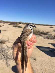
The parish is on the traditional land of the Karrengappa people. The first Europeans through the area were Burke and Wills and in the 1890s was included in the Albert Goldfield.
In 1873 [4] the area was described as "being of [the] Burke and Wills track and well watered by the Bulloo River, Tongowoko, Torrens and other creeks." At the time the area was made up of grassed downs and saltbush country. [5]
By 1892 the property was owned by Sidney Kidman who moved 10,000 sheep and 1,000 head of cattle [6] from the station, still owned by the Kidman Brothers in 1899. Kidman described it as "one of the worst in New South Wales, the 54,200 acres (21,934 ha) might carry 230 cattle but no more, much of it is a claypan that will never carry feed". [7]
Caryapundy Station most commonly known as Caryapundy or Caryapundy Swamp is a pastoral lease that once operated as a cattle station in the channel country of outback New South Wales.

Olive, also known as Olive Downs, is a civil parish of Tongowoko County in far north west New South Wales, located at 29°02′40″S 141°52′14″E.
Mount Wood, New South Wales is a remote civil parish of Tongowoko County, New South Wales near Milparinka, New South Wales.

Bolwarry, New South Wales is a civil parish of Tongowoko County, New South wales. The parish is east of Tibooburra.
Corriwelpie, New South Wales is a civil Parish, of the County of Delalah a cadareal division of New South Wales.
Korri Parish is a remote civil Parish, of the County of Delalah a cadasteral division of New South Wales.
Cullamulcha, New South Wales is a civil Parish, of the County of Delalah, a cadasteral division of New South Wales.
Thoulcanna, New South Wales is a remote civil Parish, of the County of Delalah, a cadasteral division of New South Wales.
Killen, New South Wales is a civil Parish, of the County of Delalah, a cadasteral division of New South Wales.
Berawinia, New South Wales is a remote civil Parish, of the County of Delalah, a cadasteral division of New South Wales.
Elsinora, in New South Wales, Australia, is a civil parish of the county of Delalah, a cadasteral division of New South Wales.
Catombal Parish, New South Wales is a civil Parish, of the County of Delalah, a cadasteral division of New South Wales.
Border, New South Wales is a remote civil Parish, of the County of Delalah a cadasteral division of New South Wales.
Delalah Parish is a remote civil Parish, of the County of Delalah a cadasteral division of New South Wales.
Delalah South is a remote civil Parish, of the County of Delalah a cadasteral division of New South Wales.

Kerrininna, New South Wales is a remote rural locality and civil Parish, of the Thoulcanna County a cadasteral division of New South Wales. Kerrininna Parish is on the Paroo River south of Hungerford, Queensland.
Kelly Parish is a remote rural locality on the Paroo River and a civil Parish, of the Thoulcanna County a cadasteral division of New South Wales.
Evelyn Parish, on the Paroo River, is a remote civil Parish, of Thoulcanna County, a cadasteral division of New South Wales.
Yernca is a rural locality of Bourke Shire located at 29°34′09″S 144°23′49″E and a remote civil Parish, of the Thoulcanna County a cadasteral division of New South Wales.
Thurnapatcha, New South Wales is a rural locality of Burke Shire and a remote civil Parish, of Irrara County, a cadasteral division of New South Wales.
| | This New South Wales geography article is a stub. You can help Wikipedia by expanding it. |