
Mungindi is a town and locality on the border of New South Wales (NSW) and Queensland, Australia. The town is within Moree Plains Shire in New South Wales. Within Queensland, the locality is split between the Shire of Balonne and the Goondiwindi Region with the town in the Shire of Balonne. It possesses a New South Wales postcode. Mungindi sits on the Carnarvon Highway and straddles the Barwon River which is the border between New South Wales and Queensland. At the 2016 census, Mungindi had a population of 601 on the New South Wales side, while the population on the Queensland side was 146.

Cameron Corner is an outback locality in the Shire of Bulloo, Queensland, Australia. In the 2016 census, Cameron Corner had a population of 5 people. It borders New South Wales to the south and South Australia to the west.

Haddon Corner is a heritage-listed site in Tanbar, Shire of Barcoo, Queensland, Australia. It is in outback Channel Country at South-West Queensland, on the border corner with South Australia. It was added to the Queensland Heritage Register on 9 November 2012.

Lands administrative divisions of Australia are the cadastral divisions of Australia for the purposes of identification of land to ensure security of land ownership. Most states term these divisions as counties, parishes, hundreds, and other terms. The eastern states of Queensland, New South Wales, Victoria, and Tasmania were divided into counties and parishes in the 19th century, although the Tasmanian counties were renamed land districts in the 20th century. Parts of South Australia (south-east) and Western Australia (south-west) were similarly divided into counties, and there were also five counties in a small part of the Northern Territory. However South Australia has subdivisions of hundreds instead of parishes, along with the Northern Territory, which was part of South Australia when the hundreds were proclaimed. There were also formerly hundreds in Tasmania. There have been at least 600 counties, 544 hundreds and at least 15,692 parishes in Australia, but there are none of these units for most of the sparsely inhabited central and western parts of the country.

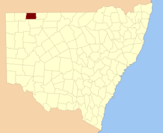
Irrara County is one of the 141 Cadastral divisions of New South Wales. It is located south of the border with Queensland, east of the Paroo River, and west of the Warrego River.
Several Queensland and New South Wales boundary encroachments are anomalies along the boundary between the Australian states of New South Wales and Queensland. Due to various historical anomalies, several stations and properties that are officially part of Queensland are south of the 29 degrees south parallel, marking the official border. Three of these can be seen easily on Google Maps near Cameron Corner, where the New South Wales Lands Department surveyor John Brewer Cameron, who spent two years from 1880 marking the border between NSW and Queensland, erected a post in September 1880.

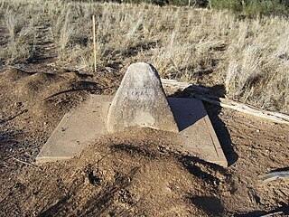
Cameron's 1 Ton Survey Post is a heritage-listed survey marker at the Barwon River, Mungindi, Shire of Balonne, Queensland, Australia. It was established in 1882. It was added to the Queensland Heritage Register on 21 October 1992.
Zero Obelisk is a heritage-listed survey marker on the east bank of the Warrego River, Barringun, Shire of Paroo, Queensland, Australia. It was established in 1879. It was added to the Queensland Heritage Register on 21 October 1992. The Zero Obelisk marks the beginning of the first official survey of the border between the colonies of Queensland and New South Wales in 1879-80.

Cameron Corner Survey Marker is a heritage-listed survey marker in the locality of Cameron Corner, Shire of Bulloo, Queensland, Australia. The survey marker is at the border corner of South-West Queensland with New South Wales and South Australia; it was established in 1880. It was added to the Queensland Heritage Register on 9 November 2012.

Yalpunga located at 29°02′40″S 142°03′13″E is a civil parish of Tongowoko County, New South Wales.
Torrens Parish, New South Wales located at 29°14′00″S 142°09′27″E is a rural locality in and a cadastral parish of Tongowoko County, two kilometers north east from the town of Tibooburra, New South Wales. The parish is north east of Tibooburra, within the Sturt National Park.

Olive, also known as Olive Downs, is a civil parish of Tongowoko County in far north west New South Wales, located at 29°02′40″S 141°52′14″E.
Silva located 29°07′49″S 142°21′47″ halfway between Bulloo Downs, Queensland, and Tibooburra, New South Wales, is a cadastral parish of Tongowoko County New South Wales.

Yanderra parish is a cadastral parish of Tongowoko County New South Wales.
Connulpie, New South Wales is a remote civil Parish, of the County of Delalah a cadasteral division of New South Wales.

Queensland is the north-eastern state of Australia and has land borders with three other Australian states and territories: New South Wales, South Australia and Northern Territory. To the north of Queensland is the Torres Strait separating the Australian mainland from Papua New Guinea. To the east of Queensland is the Coral Sea, part of the Pacific Ocean. There are many islands off the Queensland coast which form part of the state of Queensland.

John Brewer Cameron was a geodetic surveyor in Australia. He is best known for his survey of the border between Queensland and New South Wales. He also surveyed part of the border between South Australia and Western Australia.
Nerang–Murwillumbah Road is a continuous 36.4 kilometres (22.6 mi) road route in the Gold Coast region of Queensland, Australia. The entire road is signed as State Route 97. Nerang–Murwillumbah Road is a state-controlled district road, rated as a local road of regional significance (LRRS).
Tongowoko Parish is a civil land parish of Tongowoko County, New South Wales. It is bordered by the parishes of Silva, Connulpie, Calathunda, and Caryapundy.
Caryapundy Parish is a civil land parish of Tongowoko County, New South Wales, corresponding to the area of former Caryapundy Station. It shares borders with Queensland, Tongowoko Parish, Calathunda Parish, and with Corriewelpie Parish of Delalah County.
