Parish of Mount Wood

Last updated

Mount Wood, New South Wales
New South Wales
Australia New South Wales location map blank.svg
Red pog.svg
Mount Wood, New South Wales
Coordinates 29°16′58″S142°17′37″E / 29.28278°S 142.29361°E / -29.28278; 142.29361 Coordinates: 29°16′58″S142°17′37″E / 29.28278°S 142.29361°E / -29.28278; 142.29361
Postcode(s) 2880
Elevation183 m (600 ft)
Location
LGA(s) Unincorporated Far West Region [1]
Region Channel Country
County Tongowoko
State electorate(s) Barwon
Federal Division(s) Parkes [2]
Mean max tempMean min tempAnnual rainfall
27.4 °C
81 °F
13.9 °C
57 °F
230.5 mm
9.1 in

Mount Wood, New South Wales is a remote civil parish of Tongowoko County, New South Wales near Milparinka, New South Wales.

Contents

Geography

Mount wood is located at 29°16′58″S 142°17′37″E, between Tibooburra, New South Wales and Pindera Downs Aboriginal Area. The Parish now lies within the Sturt National Park, and ruins of the Mount Wood Station on the Thompson Creek are preserved there. [3] The Geography, of the parish is mostly the flat, arid landscape of the Channel Country. The parish has a Köppen climate classification of BWh (Hot desert). [4]

History

The parish is the traditional lands of the Wangkumara People. [5]

The first European was Charles Sturt who camped at nearby Preservation Creek [6] (Mount Poole) for six months during 1845, [7] and in 1861 the Burke and Wills expedition passed to the east, [8] through what is now the Pindera Downs Aboriginal Area. [9]

The push for sheep pasture had reached the Darling River in the late 1840s and 1850s, and by the early to mid-1860s pastoralists were moving up the Warrego and Paroo rivers. By the late 1870s most of north-west New South Wales had been ‘claimed’ as pastoral properties though access to permanent water in the more arid country continued to be the key factor for establishing sheep stations. The discovery of gold in the Grey Range near Mount Poole about 30 kilometres south-west of present day Tibooburra, provided the impetus for an improvement in water supplies. The gold rush that ensued led to a rapid increase in the region’s population to about 3000 people and to towns like Tibooburra and Milparinka springing up. The gold finds also triggered a rapid taking up of pastoral runs in the district. The coincidental discovery of the Great Artesian Basin led to sinking of artesian bores and the beginnings of a major travelling stock route in 1884. [10]

Mount Wood Station was taken up in late 1881 or early 1882 over an area of 368,385 acres (149,080 hectares). The number of stock peaked in 1890 when 64,000 sheep were listed for the property, equating to a stocking rate of 1 sheep per 6.25 acres. By 1900 this figure had fallen dramatically to 37,316 (1 sheep per 10.72 acres) and at the time of the last shearing in 1972, to 16,000 (1 sheep per 25 acres). Drought, invasion by rabbits and depletion of native vegetation led to this rapid decline in carrying capacity for sheep and the belated realisation that the ancient, nutrient poor ecosystem was unsuited for this type of activity. [11]

Sturt National Park was established in 1972. [12] Today the entire parish is within Sturt National Park, and is also within a smaller Conservation area listed by the NSW Heritage office. [13]

Related Research Articles

Tibooburra, New South Wales Town in New South Wales, Australia

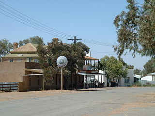
Tibooburra is a town in the far northwest of New South Wales, Australia, located 1,187 kilometres (738 mi) from the state capital, Sydney. It is most frequently visited by tourists on their way to Sturt National Park or on the way to or from Innamincka in South Australia and Birdsville in Queensland. At the 2016 census, Tibooburra had a population of 134. Although facilities in Tibooburra are quite limited, fuel, meals, and a range of accommodation options are available. All significant support services are based in Broken Hill.

Parish of Whittabranah

Whittabranah is a civil parish of Tongowoko County, New South Wales. The parish is 5 miles north of Tibooburra.

Parish of Torrens New South Wales, Australia

Torrens Parish, New South Wales located at 29°14′00″S 142°09′27″E is a rural locality in and a cadastral parish of Tongowoko County, two kilometers north east from the town of Tibooburra, New South Wales. The parish is north east of Tibooburra, within the Sturt National Park.

Parish of Olive

Olive, also known as Olive Downs, is a civil parish of Tongowoko County in far north west New South Wales, located at 29°02′40″S 141°52′14″E.

Parish of Mount King

Mount King, New South Wales is a civil parish of Poole County in far North West New South Wales, located at.

Parish of Fort Grey

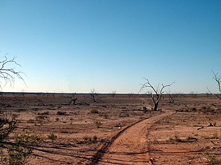
Fort Grey is a remote civil parish of Poole County in far North West New South Wales. located at 29.1731°S 141.0307°E.

Parish of Pinaroo

Pinaroo is a remote civil parish of Poole County in far north west New South Wales, located at 29°08′04″S 141°06′55″E.

Parish of Nantomoko

Nantomoko is a remote civil parish of Poole County in far North West New South Wales. located at 29°21′43″S 141°08′05″E.

Parish of Sturt

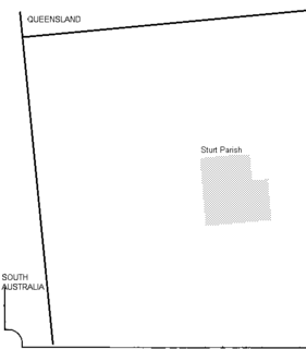
Sturt Parish is a remote civil parish of Poole County in far North West New South Wales, located at 29.433056°S 141.519722°E.

Wirratcha, New South Wales New South Wales, Australia

Wirratcha Parish is a remote rural locality and civil parish of Evelyn County in far northwest New South Wales. located at 29°38′31″S 142°01′00″E.

Mount Blackwood, New South Wales New South Wales, Australia

Mount Blackwood, New South Wales located at 29°48′37″S 141°31′10″E, is a remote rural locality and civil parish of Evelyn County in far northwest New South Wales. located at 30°04′42″S 142°45′50″E, east of the Silver City Highway . The geography of the parish is mostly the flat, arid landscape of the Channel Country. The parish has a Köppen climate classification of BWh.

Mouloonk is a remote rural locality and civil parish of Evelyn County in far northwest New South Wales. located at 30°09′04″S 141°07′08″E.

Quintyambi is a remote rural locality and civil parish of Evelyn County in far northwest New South Wales. located at 30°18′40″S 141°05′05″E.

Pingbilly, New South Wales

Pingbilly, New South Wales is a remote rural locality and civil parish of Evelyn County, New South Wales in far northwest New South Wales.

The Parish of Blackwood is a remote civil parish of Poole County in far North West New South Wales,

The Parish of Tindara is a remote civil parish of Poole County in far North West New South Wales,.

Parish of Bolwarry

Bolwarry, New South Wales is a civil parish of Tongowoko County, New South wales. The parish is east of Tibooburra.

Mount Wood Station

The Mount Wood Station, also known as simply Mt Wood, is a heritage-listed former cattle station that now forms part of the Sturt National Park in Tibooburra in the Unincorporated Far West region of New South Wales, Australia. The cattle station was built between 1890 and 1969. As a national park, the property is owned by the NSW Officer of Environment and Heritage, an agency of the Government of New South Wales. It was added to the New South Wales State Heritage Register on 2 April 1999.

Wonominta, New South Wales is a remote rural locality and civil parish of Evelyn County in far northwest New South Wales. located at 30°18′40″S 141°05′05″E.

Kilpara, New South Wales is a remote civil parish of Yantara County in far North West New South Wales, Australia. The Geography, of the parish is mostly the flat, arid landscape of the Channel Country. The parish has a Köppen climate classification of BWh.

References

  1. Tibooburra has a "village council".
  2. "Profile of the electoral division of Parkes (NSW)". Australian Electoral Commission. 25 February 2016. Retrieved 12 July 2016.
  3. Mount Wood Station .
  4. Peel, M. C.; Finlayson, B. L.; McMahon, T. A. (2007). "Updated world map of the Köppen–Geiger climate classification". Hydrol. Earth Syst. Sci. 11: 1633–1644. doi: 10.5194/hess-11-1633-2007 . ISSN   1027-5606.(direct: Final Revised Paper)
  5. Mount Wood Station, Mount Wood Station.
  6. The Sydney Morning Herald Sat 5 Mar 1932, Page 9.
  7. Sturt's Central Australian Expedition Archived 1 March 2018 at the Wayback Machine .
  8. The Burke and Wills Expedition Archived 1 March 2018 at the Wayback Machine .
  9. NSW National Parks and Wildlife service, Draft Plan of Management Sturt National Park, (2017) p 22.
  10. NSW National Parks and Wildlife service, Draft Plan of Management Sturt National Park, (2017) p 22.
  11. NSW National Parks and Wildlife service, Draft Plan of Management Sturt National Park, (2017) p23.
  12. "Tibooburra". The Sydney Morning Herald. 1 January 2009.
  13. Mount Wood Station, Mount Wood Station.