Mount Wood Station

Last updated

Mount Wood Station
Mt Wood shearers quarters Sturt NP after 10mm of rain.jpg
Mount Wood shearers' quarters after 10mm of rain, 2018
Location Sturt National Park, Tibooburra, Unincorporated Far West region of New South Wales, Australia
Coordinates 29°28′24″S142°13′33″E / 29.4732°S 142.2257°E / -29.4732; 142.2257
Built18901969
Owner Office of Environment and Heritage
Official nameMount Wood Station; Mt Wood; Whittabrinnah and Mount Wood Pastoral Company
TypeState heritage (complex / group)
Designated2 April 1999
Reference no.1001
TypeHomestead Complex
CategoryFarming and Grazing
Australia New South Wales relief location map.png
Red pog.svg
Location of Mount Wood Station in New South Wales

The Mount Wood Station, also known as simply Mt Wood, is a heritage-listed former cattle station that now forms part of the Sturt National Park in Tibooburra in the Unincorporated Far West region of New South Wales, Australia. The cattle station was built between 1890 and 1969. As a national park, the property is owned by the NSW Officer of Environment and Heritage, an agency of the Government of New South Wales. It was added to the New South Wales State Heritage Register on 2 April 1999. [1] [2]

Contents

Mount Wood Station is east of Tibooburra, New South Wales, and gives its name to the Parish of Mount Wood.

History

Expeditions were made through the area in Australia's early history. These included Charles Sturt (1847–48), who undertook an expedition into central Australia during which the party was stranded for several months at both Fort Grey and Depot Glenn (near Milparinka); and Burke and Wills (1860–61), in which this expedition passed northwards through the eastern section of the national park (probably Mount Wood. [1]

Description

Mount Wood Homestead complex is today within Sturt National Park. The national park is representative of the shrub rangeland in western New South Wales, it provides one of the best examples of this land type in conjunction with wattle ( Acacia spp.) dominated fluviatile and aeolian land types. The area, due to its size, is an important wildlife refuge, and has a significant species diversity including 246 native species, as well as a high diversity of landforms including Aeolian dune systems, Mitchell Grass Plains, the Jump Ups and Gibber Desert. [1]

The national park lies in the south-west of a vast bowl shaped depression which covers eastern central Australia, and is mainly covered by low undulating plains of Gibber Desert in the east or sand dunes in the west except for where it contains the south-western end of the Grey Range. Here the Jump Ups, a range of low flat topped hills (mesa) run through the centre of the park and along its eastern boundary. Just inside the park boundary at Tibooburra is a granite outcrop which has formations of hilltop tors. The southern extremity of the Grey Range in the north of the park has associated mesa formations and eroded gullies, the remainder of the park has the occasional stony hill and many drainage basins. [1]

The park has three major vegetation associations, these include a mulga association; saltbush association; and bluebush association. [1]

Complex features

The Mount Wood Homestead complex comprises: [1]

Landscape features, including fields;

The garden comprises a line of eucalypts c.1960 behind the kitchen and laundry/store; two trees to the right hand side (in plan) of the 1897 homestead; two paths linking the two homesteads (1897, 1935); a drift of three eucalypts in front of the 1935 homestead; a pepper tree ( Schinus molle ) near the stone hut (c.1890) and poultry runs; regrowth vegetation to the left (in plan) of the radio aerial and poultry runs; and horse yards, from the 1960s. [3] [1]

Homestead

The homestead is in fact two homesteads connected via a covered link between the 1897 homestead that is stone, square, with a verandah all around, and the second homestead. [4] [1] The homestead retains elements from each stage of its history in archaeological or standing form. Its important documents of the long history of station operations, and a potential research resource in terms of its archaeological values. [5] [1]

Shearers Quarters (1955)

Located south-east of the homestead complex and north of Thomson's Creek, this is a complex of three structures that includes the shearer's quarters (1955); a kitchen; and other unidentified structure. [1] The shearers quarters retains elements from each stage of its history in archaeological or standing form. Its important documents of the long history of station operations, and a potential research resource in terms of its archaeological values. [5] [1]

Woolshed

Located south-east of the homestead complex across (south of) Thomson's Creek near the suspension bridge. [1]

Woolscours

The woolscour has been well researched, and is still the only 19th century station-based scour demonstrated to have survived largely intact. While comparative research is still patchy, the Mount Wood woolscour appears to be a rare survival of a once common pastoral technology, critical to the settlement of the pastoral frontier. [1]

Vehicle shed

c.1960s shed on a concrete slab and pier foundation, supported by 100-millimetre (3.9 in) round painted steel pipe posts with dooden rafters and battens, clad in painted corrugated iron. The shed is roughly 20.7 metres (68 ft) long, 9.7 metres (32 ft) deep and 2.5 metres (8 ft 2 in) high. Wooden roof support structure (battens and beams). [6] [1]

Other structures include outstations, archaeological sites, ruins that include shed base (beside the vehicle shed); former approach track (towards garden and homestead); tank base (near generator shed); [1] standing structures include, in a cluster around the stables, gallows (1960s); dog kennels (c.1960); horse yards (1960s); cow bail; stables (1960s); generator shed (1955); fuel shed (1955); metal racks; g.i.tank; blacksmith's shop and workshop (c.1920); pump (1930s); and vehicle shed. [1] In a cluster around the homestead there is a laundry and store (1958); kitchen (1939); meat house; saddle room; stone cistern (1897); station tanks (4); galvanised iron fence; stone hut (c.1890); poultry runs; radio aerial. [1] To the left of the homestead and stables complex (in plan), site of radio aerial arrays. [1]

The individual elements vary in age, but even the most recent are located upon traditional sites of pastoral operations, and an unusually complete representative sample of the elements typical of pastoral stations survives, as archaeological sites, ruins, standing structures or landscape features. [1] [7]

Heritage listing

As at 11 January 2002, Mount Wood Homestead complex, shearers quarters, woolshed, woolscours and outstations are significant in that they demonstrate a continuity of pastoral activity in the arid north-west of NSW over a one hundred-year period. The individual elements vary in age, but even the most recent are located upon traditional sites of pastoral operations, and an unusually complete representative sample of the elements typical of pastoral stations survives, as archaeological sites, ruins, standing structures or landscape features. The extant evidence clearly illustrates the themes of housing, isolation, land tenure/settlement, pastoralism and technology. Some elements of the place are significant in their own right. [1]

The woolscour has been well researched, and is still the only 19th century station-based scour demonstrated to have survived largely intact. While comparative research is still patchy, the Mount Wood woolscour appears to be a rare survival of a once common pastoral technology, critical to the settlement of the pastoral frontier. [1]

The shearers quarters and homestead retain elements from each stage of their history in archaeological or standing form. They are both important documents of the long history of station operations, and a potential research resource in terms of their archaeological values. Individual elements have aesthetic (architectural) and scientific (archaeological and technological) values. [1]

The survival of the range of elements present at Mount Wood is believed to be already uncommon in western NSW, and may become increasingly rare as time passes. [1] [7]

Mount Wood Station was listed on the New South Wales State Heritage Register on 2 April 1999. [1]

See also

Related Research Articles

<span class="mw-page-title-main">Sturt National Park</span> Protected area in New South Wales, Australia

The Sturt National Park is a protected national park that is located in the arid far north-western corner of New South Wales, in eastern Australia. The 325,329-hectare (803,910-acre) national park is situated approximately 1,060 kilometres (660 mi) northwest of Sydney and the nearest town is Tibooburra, 6 kilometres (3.7 mi) away.

<span class="mw-page-title-main">Dundullimal Homestead</span> Slab hut in New South Wales, Australia

Dundullimal Homestead is a heritage-listed former pastoral station and now cultural facility, house museum and events centre. The Australian colonial slab hut-type homestead is located approximately 7 kilometres (4.3 mi) south of Dubbo in the Dubbo Regional Council local government area of New South Wales, on Obley Road, set on the bank of the Macquarie River. The homestead was built in c. 1842 by John Maughan and is also known as Dundullimal. The property is owned by National Trust of Australia, NSW branch. It was added to the New South Wales State Heritage Register on 1 March 2002, and is listed on the Register of the National Estate.

<span class="mw-page-title-main">Truro, South Australia</span> Town in South Australia

Truro is a town in South Australia, 80 km northeast of Adelaide. It is situated in an agricultural and pastoral district on the Sturt Highway, east of the Barossa Valley, where the highway crosses somewhat lofty and rugged parts of the Mount Lofty Ranges. At the 2021 census, Truro had a population of 523.

<span class="mw-page-title-main">Tibooburra</span> Town in New South Wales, Australia

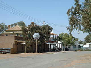
Tibooburra is a town in the far northwest of New South Wales, Australia, located 1,187 kilometres (738 mi) from the state capital, Sydney. It is most frequently visited by tourists on their way to Sturt National Park or on the way to or from Innamincka in South Australia and Birdsville in Queensland. At the 2016 census, Tibooburra had a population of 134. Although facilities in Tibooburra are quite limited, fuel, meals, and a range of accommodation options are available. All significant support services are based in Broken Hill.

<i>The Golden Fleece</i> (painting) Painting by Tom Roberts

The Golden Fleece, originally known as Shearing at Newstead, is an 1894 painting by the Australian artist Tom Roberts. The painting depicts sheep shearers plying their trade in a timber shearing shed at Newstead North, a sheep station near Inverell on the Northern Tablelands of New South Wales. The same shed is depicted in another of Roberts' works, Shearing Shed, Newstead (1894).

<span class="mw-page-title-main">Lake Pinaroo</span> Ephemeral saline or brackish lake in Sturt National Park, Far West New South Wales

Lake Pinaroo lies in the north west corner of Sturt National Park, a protected national park in the Far West region of New South Wales, Australia. The location covers an area of 718.8 ha, approximately 80km north-west of Tibooburra and 24km south-east of Cameron Corner. Grid coordinates 29°06’S, 141°13’E. On 19 March 1996 the lake was recognised as a wetland of international importance by designation (RS799) under the Ramsar Convention.

<span class="mw-page-title-main">Jondaryan Woolshed</span> Historic site in Queensland, Australia

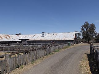
Jondaryan Woolshed is a heritage-listed shearing shed at Evanslea Road, Jondaryan, Queensland, Australia. It was built in 1859-60 to replace an earlier, smaller woolshed on the former Jondaryan pastoral station, which was at one stage the largest freehold station in Queensland. The woolshed was the scene of significant labour conflict in the late 1880s and early 1890s, as the station became a test case for the new Queensland Shearers Union in the lead-up to the 1891 Australian shearers' strike.

<span class="mw-page-title-main">Jondaryan Homestead</span> Historic site in Queensland, Australia

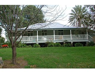
Jondaryan Homestead is a heritage-listed homestead at Evanslea Road, Jondaryan, Toowoomba Region, Queensland, Australia. It was the base of the former Jondaryan pastoral station, which was originally taken up in 1840, and at one time was the largest freehold station in Queensland. The site contains the current house, which was built after the original was destroyed by fire in 1937, the original kitchen dating from 1844, and a kitchen, butcher's shop, shearer's quarters, stables, dairy, toilet block and store, many dating from the 1860s. It also contains the remains of horse stalls, a slaughterhouse, hide store, and Chinese gardener's glasshouse. It was added to the Queensland Heritage Register on 21 October 1992.

<span class="mw-page-title-main">Isis Downs Woolshed</span> Historic site in Queensland, Australia

Isis Downs Woolshed is a heritage-listed shearing shed at Isisford-Blackall Road, Isisford, Longreach Region, Queensland, Australia. It was designed by Kay, MacNicol and Company Engineers and built from 1913 to 1914 by Dorman Long and Company (Melbourne). It was added to the Queensland Heritage Register on 18 September 2008.

<span class="mw-page-title-main">Darr River Downs</span> Historic site in Queensland, Australia

Darr River Downs is a heritage-listed homestead at Landsborough Highway, Morella, Longreach Region, Queensland, Australia. It was built from 1870s circa to 1900s circa. It was added to the Queensland Heritage Register on 27 June 2003.

Mount Wood, New South Wales is a remote civil parish of Tongowoko County, New South Wales near Milparinka, New South Wales.

The Avoca Homestead Complex is a heritage-listed former station homestead and station facilities and now catered accommodation and visitor attraction at 1122a Low Darling Road, Wentworth, in the Wentworth Shire, New South Wales, Australia. It was built between 1871 and 1879. It is also known as the Avoca Station Homestead and outbuildings. It was added to the New South Wales State Heritage Register on 8 April 2016.

<span class="mw-page-title-main">Cliefden, Mandurama</span> Historic site in New South Wales, Australia

Cliefden is a heritage-listed homestead at 1521 Belubula Way, Mandurama, Blayney Shire, New South Wales, Australia. It is one of a group of historic sites labelled the Ben Hall Sites for their association with bushranger Ben Hall, along with Ben Hall's Death Site, the Bushranger Hotel, Escort Rock, the Grave of Ben Hall and Wandi. It was built from 1842. It was added to the New South Wales State Heritage Register on 8 October 2010.

<span class="mw-page-title-main">Old Errowanbang Woolshed</span> Historic site in New South Wales, Australia

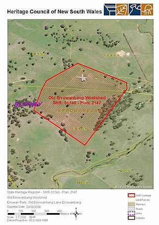
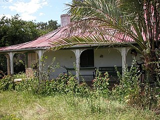
Old Errowanbang Woolshed is a heritage-listed shearing shed at Errowan Park, Old Errowanbang Lane, Errowanbang, Blayney Shire, New South Wales, Australia. It was designed by Watt and built in 1886. It is also known as Errowanbang Woolshed. It was added to the New South Wales State Heritage Register on 23 June 2006.

<span class="mw-page-title-main">Kinchega Woolshed</span> Heritage-listed former shearing shed in NSW, Australia

Kinchega Woolshed is a heritage-listed former shearing shed located 15km south-west of Menindee township, Central Darling Shire, New South Wales, Australia. It was built from in 1875. The property is owned by the New South Wales Office of Environment and Heritage. It was added to the New South Wales State Heritage Register on 2 April 1999.

<span class="mw-page-title-main">Willandra Homestead</span> Historic site in New South Wales, Australia

Willandra Homestead is a heritage-listed homestead in the Willandra National Park, Carrathool Shire, New South Wales, Australia. It was designed by Laird & Buchan and built in 1918 by Frederick Coulson. The property is owned by the New South Wales Office of Environment and Heritage. It was added to the New South Wales State Heritage Register on 2 April 1999.

<span class="mw-page-title-main">Savernake Station</span> Historic site in New South Wales, Australia

Savernake Station is a heritage-listed working farm located at 2341 Mulwala Road, Savernake, Federation Council, New South Wales, Australia. It was designed and built from 1862. It is also known as Savernake Homestead. It was added to the New South Wales State Heritage Register on 15 March 2013. The heritage listing includes the station's moveable heritage, including significant collections and archives relating to the property.

Mulwala Homestead is a heritage-listed homestead at North Road, Mulwala, New South Wales, Australia. It was added to the Australian Commonwealth Heritage List on 22 June 2004.

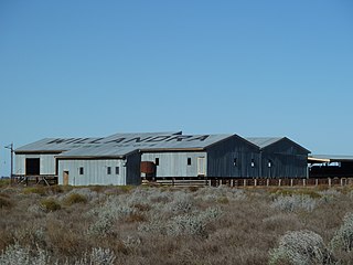
Windy Station Woolshed is a heritage-listed shearing shed at Windy Road, Pine Ridge, Liverpool Plains Shire, New South Wales, Australia. It was designed by Fred B Menkens and built in 1901 by Thomas and William Cowan. It was added to the New South Wales State Heritage Register on 19 January 2018.

East Warrah Woolshed is a heritage-listed shearing shed at Merriwa-Murrurundi Road, Warrah Creek, Liverpool Plains Shire, New South Wales, Australia. It was designed by Samuel Craik and built from 1863 to 1864. It was added to the New South Wales State Heritage Register on 10 August 2018.

References

  1. 1 2 3 4 5 6 7 8 9 10 11 12 13 14 15 16 17 18 19 20 21 22 23 24 25 "Mount Wood Station". New South Wales State Heritage Register . Department of Planning & Environment. H01001. Retrieved 2 June 2018. CC BY icon.svg Text is licensed by State of New South Wales (Department of Planning and Environment) under CC-BY 4.0 licence .
  2. "Draft Plan of Management Sturt National Park" (PDF). NSW National Parks & Wildlife Service . 2017. p. 22.
  3. Brueggemann, 2016, 3. 7
  4. Inter-war, c.1935
  5. 1 2 Freeman, 1997
  6. Brueggemann, 2016, 4
  7. 1 2 Freeman, 1997: Vol 1, p51

Bibliography

Attribution

CC BY icon-80x15.png This Wikipedia article contains material from Mount Wood Station , entry number 01001 in the New South Wales State Heritage Register published by the State of New South Wales (Department of Planning and Environment) 2018 under CC-BY 4.0 licence , accessed on 2 June 2018.

Commons-logo.svg Media related to Mount Wood Station at Wikimedia Commons