Rous County

Last updated

Map all coordinates using: OpenStreetMap  
Download coordinates as: KML
Rous
New South Wales
Rous NSW.PNG
Location in New South Wales
Lands administrative divisions around Rous:
Merivale (Qld) Ward (Qld) Pacific Ocean
Buller Rous Pacific Ocean
Drake Richmond Pacific Ocean

Rous County is one of the 141 Cadastral divisions of New South Wales. It is located at the north-east tip of the state. It is bordered on the north by the border with Queensland and on the south by the Richmond River. It contains Lismore, Byron Bay and Murwillumbah.

Contents

Rous County was named in honour of Admiral Henry John Rous (1795-1877). [1]

Parishes within this county

A full list of parishes found within this county; their current LGA and mapping coordinates to the approximate centre of each location is as follows:

ParishLGACoordinates
Babyil Kyogle Shire 28°37′54″S152°45′04″E / 28.63167°S 152.75111°E / -28.63167; 152.75111 (Babyil Parish)
Ballina Ballina Shire 28°49′54″S153°33′04″E / 28.83167°S 153.55111°E / -28.83167; 153.55111 (Ballina Parish)
Berwick Tweed Shire 28°13′54″S153°25′04″E / 28.23167°S 153.41778°E / -28.23167; 153.41778 (Berwick Parish)
Bexhill City of Lismore 28°45′54″S153°22′04″E / 28.76500°S 153.36778°E / -28.76500; 153.36778 (Bexhill Parish)
Billinudgel Tweed Shire 28°30′54″S153°30′04″E / 28.51500°S 153.50111°E / -28.51500; 153.50111 (Billinudgel Parish)
Bingal Ballina Shire 28°56′54″S153°28′04″E / 28.94833°S 153.46778°E / -28.94833; 153.46778 (Bingal Parish)
Blakebrook City of Lismore 28°45′54″S153°16′04″E / 28.76500°S 153.26778°E / -28.76500; 153.26778 (Blakebrook Parish)
Boorabee City of Lismore 28°39′54″S153°05′04″E / 28.66500°S 153.08444°E / -28.66500; 153.08444 (Boorabee Parish)
Broadwater City of Lismore 29°00′54″S153°24′04″E / 29.01500°S 153.40111°E / -29.01500; 153.40111 (Broadwater Parish)
Brunswick Byron Shire 28°35′54″S153°31′04″E / 28.59833°S 153.51778°E / -28.59833; 153.51778 (Brunswick Parish)
Bungabbee City of Lismore 28°43′54″S153°08′04″E / 28.73167°S 153.13444°E / -28.73167; 153.13444 (Bungabbee Parish)
Burrell Kyogle Shire 28°23′54″S153°15′04″E / 28.39833°S 153.25111°E / -28.39833; 153.25111 (Burrell Parish)
Byron Byron Shire 28°39′54″S153°32′04″E / 28.66500°S 153.53444°E / -28.66500; 153.53444 (Byron Parish)
Chillingham Kyogle Shire 28°16′54″S153°13′04″E / 28.28167°S 153.21778°E / -28.28167; 153.21778 (Chillingham Parish)
Clunes City of Lismore 28°40′54″S153°25′04″E / 28.68167°S 153.41778°E / -28.68167; 153.41778 (Clunes Parish)
Condong Tweed Shire 28°19′54″S153°27′04″E / 28.33167°S 153.45111°E / -28.33167; 153.45111 (Condong Parish)
Coraki City of Lismore 29°00′54″S153°19′04″E / 29.01500°S 153.31778°E / -29.01500; 153.31778 (Coraki Parish)
Cougal Kyogle Shire 28°22′54″S152°57′04″E / 28.38167°S 152.95111°E / -28.38167; 152.95111 (Cougal Parish)
Cudgen Tweed Shire 28°16′54″S153°33′04″E / 28.28167°S 153.55111°E / -28.28167; 153.55111 (Cudgen Parish)
Dunbible Tweed Shire 28°22′54″S153°23′04″E / 28.38167°S 153.38444°E / -28.38167; 153.38444 (Dunbible Parish)
Dunoon City of Lismore 28°39′54″S153°19′04″E / 28.66500°S 153.31778°E / -28.66500; 153.31778 (Dunoon Parish)
Dyraaba Kyogle Shire 28°47′54″S152°47′04″E / 28.79833°S 152.78444°E / -28.79833; 152.78444 (Dyraaba Parish)
East Gundurimba City of Lismore 28°51′54″S153°18′04″E / 28.86500°S 153.30111°E / -28.86500; 153.30111 (East Gundurimba Parish)
Ettrick Kyogle Shire 28°34′54″S152°52′04″E / 28.58167°S 152.86778°E / -28.58167; 152.86778 (Ettrick Parish)
Fairy Mount Kyogle Shire 28°33′54″S153°03′04″E / 28.56500°S 153.05111°E / -28.56500; 153.05111 (Fairy Mount Parish)
Findon Kyogle Shire 28°22′54″S152°51′04″E / 28.38167°S 152.85111°E / -28.38167; 152.85111 (Findon Parish)
Geneva Kyogle Shire 28°36′54″S152°57′04″E / 28.61500°S 152.95111°E / -28.61500; 152.95111 (Geneva Parish)
Gooninbar Kyogle Shire 28°29′54″S153°16′04″E / 28.49833°S 153.26778°E / -28.49833; 153.26778 (Gooninbar Parish)
Hanging Rock City of Lismore 28°31′54″S153°08′04″E / 28.53167°S 153.13444°E / -28.53167; 153.13444 (Hanging Rock Parish)
Jasper Byron Shire 28°36′54″S153°26′04″E / 28.61500°S 153.43444°E / -28.61500; 153.43444 (Jasper Parish)
Jiggi City of Lismore 28°36′54″S153°08′04″E / 28.61500°S 153.13444°E / -28.61500; 153.13444 (Jiggi Parish)
Kunghur Tweed Shire 28°27′54″S153°12′04″E / 28.46500°S 153.20111°E / -28.46500; 153.20111 (Kunghur Parish)
Kynnumboon Tweed Shire 28°16′54″S153°20′04″E / 28.28167°S 153.33444°E / -28.28167; 153.33444 (Kynnumboon Parish)
Kyogle Shire Richmond Valley Council 28°45′54″S153°00′04″E / 28.76500°S 153.00111°E / -28.76500; 153.00111 (Kyogle Shire Parish)
Langwell Kyogle Shire 28°38′54″S152°51′04″E / 28.64833°S 152.85111°E / -28.64833; 152.85111 (Langwell Parish)
Lismore City of Lismore 28°49′54″S153°23′04″E / 28.83167°S 153.38444°E / -28.83167; 153.38444 (Lismore Parish)
Loadstone Kyogle Shire 28°25′54″S152°57′04″E / 28.43167°S 152.95111°E / -28.43167; 152.95111 (Loadstone Parish)
Meerschaum Ballina Shire 28°53′54″S153°24′04″E / 28.89833°S 153.40111°E / -28.89833; 153.40111 (Meerschaum Parish)
Mooball Tweed Shire 28°24′54″S153°29′04″E / 28.41500°S 153.48444°E / -28.41500; 153.48444 (Mooball Parish)
Mullumbimby Byron Shire 28°31′54″S153°26′04″E / 28.53167°S 153.43444°E / -28.53167; 153.43444 (Mullumbimby Parish)
Mummulgum Kyogle Shire 28°52′54″S152°47′04″E / 28.88167°S 152.78444°E / -28.88167; 152.78444 (Mummulgum Parish)
Murwillumbah Tweed Shire 28°19′54″S153°17′04″E / 28.33167°S 153.28444°E / -28.33167; 153.28444 (Murwillumbah Parish)
Newrybar Ballina Shire 28°44′54″S153°33′04″E / 28.74833°S 153.55111°E / -28.74833; 153.55111 (Newrybar Parish)
Nimbin City of Lismore 28°37′54″S153°14′04″E / 28.63167°S 153.23444°E / -28.63167; 153.23444 (Nimbin Parish)
North Casino Richmond Valley Council 28°46′54″S153°04′04″E / 28.78167°S 153.06778°E / -28.78167; 153.06778 (North Casino Parish)
North Codrington City of Lismore 28°55′54″S153°15′04″E / 28.93167°S 153.25111°E / -28.93167; 153.25111 (North Codrington Parish)
North Lismore City of Lismore 28°44′54″S153°18′04″E / 28.74833°S 153.30111°E / -28.74833; 153.30111 (North Lismore Parish)
Nullum Tweed Shire 28°26′54″S153°22′04″E / 28.44833°S 153.36778°E / -28.44833; 153.36778 (Nullum Parish)
Pimlico Ballina Shire 28°53′54″S153°30′04″E / 28.89833°S 153.50111°E / -28.89833; 153.50111 (Pimlico Parish)
Queebun Kyogle Shire 28°44′54″S152°51′04″E / 28.74833°S 152.85111°E / -28.74833; 152.85111 (Queebun Parish)
Roseberry Kyogle Shire 28°29′54″S152°52′04″E / 28.49833°S 152.86778°E / -28.49833; 152.86778 (Roseberry Parish)
Runnymede Kyogle Shire 28°39′54″S153°02′04″E / 28.66500°S 153.03444°E / -28.66500; 153.03444 (Runnymede Parish)
Runnymede Kyogle Shire 28°40′54″S153°00′04″E / 28.68167°S 153.00111°E / -28.68167; 153.00111 (Runnymede Parish)
Sherwood Kyogle Shire 28°28′54″S152°46′04″E / 28.48167°S 152.76778°E / -28.48167; 152.76778 (Sherwood Parish)
South Gundurimba City of Lismore 28°51′54″S153°13′04″E / 28.86500°S 153.21778°E / -28.86500; 153.21778 (South Gundurimba Parish)
South Lismore City of Lismore 28°48′54″S153°15′04″E / 28.81500°S 153.25111°E / -28.81500; 153.25111 (South Lismore Parish)
Stratheden Kyogle Shire 28°44′54″S152°57′04″E / 28.74833°S 152.95111°E / -28.74833; 152.95111 (Stratheden Parish)
Terania City of Lismore 28°33′54″S153°15′04″E / 28.56500°S 153.25111°E / -28.56500; 153.25111 (Terania Parish)
Terranora Tweed Shire 28°12′54″S153°30′04″E / 28.21500°S 153.50111°E / -28.21500; 153.50111 (Terranora Parish)
Teven Byron Shire 28°45′54″S153°32′04″E / 28.76500°S 153.53444°E / -28.76500; 153.53444 (Teven Parish)
Tomki Richmond Valley Council 28°49′54″S153°08′04″E / 28.83167°S 153.13444°E / -28.83167; 153.13444 (Tomki Parish)
Toolond Tweed Shire 28°31′54″S153°21′04″E / 28.53167°S 153.35111°E / -28.53167; 153.35111 (Toolond Parish)
Toonumbar Kyogle Shire 28°32′54″S152°46′04″E / 28.54833°S 152.76778°E / -28.54833; 152.76778 (Toonumbar Parish)
Tuckombil Ballina Shire 28°49′54″S153°28′04″E / 28.83167°S 153.46778°E / -28.83167; 153.46778 (Tuckombil Parish)
Tuckurimba City of Lismore 28°55′54″S153°19′04″E / 28.93167°S 153.31778°E / -28.93167; 153.31778 (Tuckurimba Parish)
Tunstall City of Lismore 28°41′54″S153°14′04″E / 28.69833°S 153.23444°E / -28.69833; 153.23444 (Tunstall Parish)
Tyalgum Tweed Shire 28°22′54″S153°09′04″E / 28.38167°S 153.15111°E / -28.38167; 153.15111 (Tyalgum Parish)
Tygalgah Tweed Shire 28°18′54″S153°25′04″E / 28.31500°S 153.41778°E / -28.31500; 153.41778 (Tygalgah Parish)
Unumgar Kyogle Shire 28°22′54″S152°45′04″E / 28.38167°S 152.75111°E / -28.38167; 152.75111 (Unumgar Parish)
Warrazambil Kyogle Shire 28°29′54″S153°04′04″E / 28.49833°S 153.06778°E / -28.49833; 153.06778 (Warrazambil Parish)
Whian Whian City of Lismore 28°35′54″S153°20′04″E / 28.59833°S 153.33444°E / -28.59833; 153.33444 (Whian Whian Parish)
Wiangaree Kyogle Shire 28°33′54″S153°00′04″E / 28.56500°S 153.00111°E / -28.56500; 153.00111 (Wiangaree Parish)
Wollumbin Tweed Shire 28°22′54″S153°19′04″E / 28.38167°S 153.31778°E / -28.38167; 153.31778 (Wollumbin Parish)
Worendo Kyogle Shire 28°22′54″S153°04′04″E / 28.38167°S 153.06778°E / -28.38167; 153.06778 (Worendo Parish)
Wyndham Kyogle Shire 28°30′54″S152°56′04″E / 28.51500°S 152.93444°E / -28.51500; 152.93444 (Wyndham Parish)

Dunoon dam proposal

The council, which is the authority responsible for the water supply for most of the Ballina, Byron, Lismore and Richmond Valley council areas, published its draft water strategy in June 2020, which includes a 50-gigalitre (1.8×10⁹ cu ft) dam at Dunoon about 20 kilometres (12 mi) north of Lismore. The council has been aware of Indigenous concerns since the matter was first considered in the 1990s, and was committed to working with local communities to mitigate concerns. An impact assessment of the site had identified various artefacts and burial sites in the area. [2]

Related Research Articles

Lismore, New South Wales City in New South Wales, Australia

Lismore is a city in northeastern New South Wales, Australia and the main population centre in the City of Lismore local government area; it is also a regional centre in the Northern Rivers region of the State. It is situated on a low flood plain on the banks of the Wilsons River near the latter's junction with Leycester Creek, both tributaries of the Richmond River which enters the Pacific Ocean at Ballina, 30 km (19 mi) to the east. The original settlement initially developed as a grazing property, then became a timber and agricultural based town and inland port based around substantial river traffic, which declined and then ceased around the mid-twentieth century. The city is also located on the Bruxner Highway which crosses the Wilsons River at Lismore, and was formerly a stop on the Casino-Murwillumbah railway line. It is the home of one of the three campuses of Southern Cross University.

Byron Bay Town in New South Wales, Australia

Byron Bay is a beachside town located in the far-northeastern corner of the state of New South Wales, Australia on Bundjalung Country. It is located 772 kilometres (480 mi) north of Sydney and 165 kilometres (103 mi) south of Brisbane. Cape Byron, a headland adjacent to the town, is the easternmost point of mainland Australia. At the 2016 census, the town had a permanent population of 9,246. It is the largest town of Byron Shire, though not the shire's administrative centre.

Northern Rivers Region in New South Wales, Australia

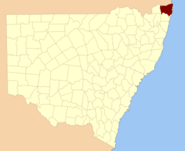
Northern Rivers is the most north-easterly region of the Australian state of New South Wales, located between 590 kilometres (370 mi) and 820 kilometres (510 mi) north of the state capital, Sydney, and encompasses the catchments and fertile valleys of the Clarence, Richmond, and Tweed rivers. It extends from Tweed Heads in the north to the southern extent of the Clarence river catchment which lies between Grafton, and Coffs Harbour, and includes the main towns of Tweed Heads, Byron Bay, Ballina, Kyogle, Lismore, Casino and Grafton. At its most northern point, the region is 102 kilometres (63 mi) south south–east of the Queensland capital, Brisbane.

Ballina, New South Wales Town in New South Wales, Australia

Ballina is a town in the Northern Rivers region of New South Wales, Australia, and the seat of the Ballina Shire local government area. Ballina's urban population at June 2018 was 26,381. The town lies on the Richmond River and serves as a gateway to Byron Bay.

Hawkesbury River River in New South Wales, Australia

The Hawkesbury River, or Hawkesbury-Nepean River, is a river located northwest of Sydney, New South Wales, Australia. The Hawkesbury River and its associated main tributary, the Nepean River, almost encircle the metropolitan region of Sydney.

Tweed River (New South Wales)

The Tweed River is a river situated in the Northern Rivers district of New South Wales, Australia. From the middle reaches of its course, the state boundary between New South Wales and Queensland is located approximately 10 kilometres (6.2 mi) north.

Richmond River River in New South Wales, Australia

The Richmond River is a river situated in the Northern Rivers region of New South Wales, Australia.

Dunoon, New South Wales Town in New South Wales, Australia

Dunoon is a small village within the City of Lismore LGA in the Northern Rivers region of New South Wales, Australia. At the 2006 census, Dunoon had a population of 372 people. In the 2011 census the population was 824. It is self-proclaimed as the Macadamia capital of Australia.

City of Lismore Local government area in New South Wales, Australia

The City of Lismore is a local government area in the Northern Rivers region of New South Wales, Australia. The seat of the local government area is Lismore, a major regional centre of the state.

Rocky Creek Dam Dam in Northern Rivers, New South Wales

Rocky Creek Dam is a minor rock fill clay core embankment dam across the Rocky Creek, located upstream of Lismore in the Northern Rivers region of New South Wales, Australia. The dam's main purpose is to supply potable water for the region, including Lismore, Ballina, Byron Bay, Evans Head and Alstonville. The impounded reservoir is called Rocky Lake.

Byron was an electoral district of the Legislative Assembly in the Australian state of New South Wales created in 1913, replacing Rous, and named after Cape Byron. With the introduction of proportional representation in 1920, Byron absorbed Lismore and Clarence and elected three members. With the end of proportional representation in 1927, it was redivided into the single-member electorates of Byron, Lismore and Clarence. In 1988, Byron was replaced by Ballina and Murwillumbah.

Rous was an electoral district of the Legislative Assembly in the Australian state of New South Wales, created in the 1904 re-distribution of electorates following the 1903 New South Wales referendum, which required the number of members of the Legislative Assembly to be reduced from 125 to 90. It consisted of parts of Lismore and The Tweed. It was named after Rous County, between the Tweed and Richmond Rivers and Henry John Rous, who explored the rivers. In 1913, it was replaced by Byron.

Murwillumbah railway line Former railway line in New South Wales

The Murwillumbah railway line is a mostly disused railway line in far north-eastern Northern Rivers New South Wales, Australia. The line ran from Casino to Lismore, Byron Bay, Mullumbimby and Murwillumbah, opening in 1894. It is one of only two branches off the North Coast line,. Train services to the region ceased in May 2004. The line from Casino to Bentley and Murwillumbah to Crabbes Creek was formally closed on 23 September 2020 to facilitate the construction of a rail trail.

Pindari Dam Dam in North West Slopes, New South Wales

Pindari Dam is a minor concrete faced rockfill embankment dam with an ungated uncontrolled rock cut with concrete sill spillway across the Severn River located upstream of the town of Ashford, in the North West Slopes region of New South Wales, Australia. The dam's purpose includes flood mitigation, hydro-power, irrigation, water supply and conservation. The impounded reservoir is called Lake Pindari.

Australian Aboriginal sacred site Places deemed significant and meaningful by Aboriginal Australians based on their beliefs

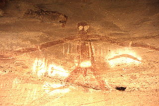
An Australian Aboriginal sacred site is a place deemed significant and meaningful by Aboriginal Australians based on their beliefs. It may include any feature in the landscape, and in coastal areas, these may lie underwater. The site's status is derived from an association with some aspect of social and cultural tradition, which is related to ancestral beings, collectively known as Dreamtime, who created both physical and social aspects of the world. The site may have its access restricted based on gender, clan or other Aboriginal grouping, or other factors.

Wilsons River (New South Wales)

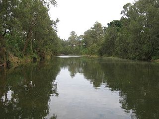
Wilsons River, a perennial river and part of the Richmond River catchment, is situated in the Northern Rivers district of New South Wales, Australia.

Rous River

Rous River, a perennial river of the Tweed River catchment, is located in the Northern Rivers region of New South Wales, Australia.

The Bundjalung people are a large Aboriginal nation, a federation of a number of groups of clans which occupy the land from Grafton on the Clarence river of northern New South Wales north to the town of Ipswich and the Beaudesert, in southern Queensland, and down around the other side of the Great Dividing Range and back to Grafton. In the north, Bundjalung Nation shares a border with Yuggera Nation and Barrunggam Nation; to the east the Tasman Sea ; to the south Gumbaynggirr Nation; and to the west it borders Ngarabal Nation.

Lismore High Campus School in Australia

Lismore High Campus, part of The Rivers Secondary College, is a government-funded co-educational comprehensive secondary day school campus, located on Dalley Street, East Lismore, in the Northern Rivers region of New South Wales, Australia.

Nightcap Range

The Nightcap Range is a mountain range located in the Northern Rivers region of New South Wales, Australia, in the area between Lismore and the New South Wales-Queensland border. It includes Mount Burrell and Mount Nardi as well as containing the Nightcap National Park. The range is mainly covered with relict warm temperate rainforest and contains several rare and/or endemic species, most notably the Nightcap oak and the Minyon quandong.

References

  1. "Rous". Geographical Names Register (GNR) of NSW. Geographical Names Board of New South Wales . Retrieved 3 August 2013. OOjs UI icon edit-ltr-progressive.svg
  2. MacKenzie, Bruce (19 June 2020). "Indigenous heritage sites could be underwater if new dam is built on New South Wales north coast". ABC News. Australian Broadcasting Corporation. Retrieved 5 July 2020.