Oxley County

Last updated

Oxley
New South Wales
Oxley NSW.PNG
Location in New South Wales
Lands administrative divisions around Oxley:
Canbelego Gregory Gregory
Flinders Oxley Ewenmar
Flinders Kennedy Narromine

Oxley County, New South Wales is one of the 141 cadastral divisions of New South Wales. It is located between the Bogan River on the west, and the Macquarie River on the east. This is the area approximately between Warren and Nyngan.

Oxley County was named in honour of Surveyor-General and explorer John Joseph William Molesworth Oxley (1785-1828). [1]

The County is roughly a diamond shape and is located generally between the Bogan and Macquarie Rivers in central New South Wales.

Map of Oxley County in New South Wales in 1876.png There are three towns in the County, Nyngan along the western edge and Warren on the Macquarie river, in the east and the nearby railway junction of Nevertire.

The entire Country is incorporated, with seats of local government at Warren and Nyngan.

The economy of the country is mostly broad acre farming though some intensive industrial agriculture is found at Snakes Plain between Warren and Nevertire. The topography of the country is flat and it has a Koppen Climate Classification of BsK (Hot Semi Arid).

Parishes within this county

A full list of parishes found within this county; their current LGA and mapping coordinates to the approximate centre of each location is as follows:

ParishLGACoordinates
Balcombe Warren Shire 31°59′54″S147°30′04″E / 31.99833°S 147.50111°E / -31.99833; 147.50111 (Balcombe)
Beablebar Warren Shire 31°47′54″S147°24′04″E / 31.79833°S 147.40111°E / -31.79833; 147.40111 (Beablebar)
Beardina Warren Shire 31°27′54″S147°38′04″E / 31.46500°S 147.63444°E / -31.46500; 147.63444 (Beardina)
Beelban Warren Shire 31°49′54″S147°36′04″E / 31.83167°S 147.60111°E / -31.83167; 147.60111 (Beelban)
Beleringar Warren Shire 31°34′54″S147°36′04″E / 31.58167°S 147.60111°E / -31.58167; 147.60111 (Beleringar)
Boro Warren Shire 31°59′54″S147°37′04″E / 31.99833°S 147.61778°E / -31.99833; 147.61778 (Boro)
Buddabadah Bogan Shire 31°53′54″S147°14′04″E / 31.89833°S 147.23444°E / -31.89833; 147.23444 (Buddabadah)
Cajildry Warren Shire 32°14′54″S147°18′04″E / 32.24833°S 147.30111°E / -32.24833; 147.30111 (Cajildry)
Carual Warren Shire 31°37′54″S147°44′04″E / 31.63167°S 147.73444°E / -31.63167; 147.73444 (Carual)
Cookandoon Bogan Shire 31°35′54″S147°24′04″E / 31.59833°S 147.40111°E / -31.59833; 147.40111 (Cookandoon)
Cremorne Warren Shire 31°53′54″S147°26′04″E / 31.89833°S 147.43444°E / -31.89833; 147.43444 (Cremorne)
Curtis Warren Shire 32°02′54″S147°34′04″E / 32.04833°S 147.56778°E / -32.04833; 147.56778 (Curtis)
Darouble Bogan Shire 31°41′54″S147°14′04″E / 31.69833°S 147.23444°E / -31.69833; 147.23444 (Darouble)
Dooran Warren Shire 31°33′54″S147°38′04″E / 31.56500°S 147.63444°E / -31.56500; 147.63444 (Dooran)
Egelabra Warren Shire 31°47′54″S147°50′04″E / 31.79833°S 147.83444°E / -31.79833; 147.83444 (Egelabra)
Eilginbah Warren Shire 31°43′54″S147°38′04″E / 31.73167°S 147.63444°E / -31.73167; 147.63444 (Eilginbah)
Elengerah Warren Shire 31°51′54″S147°54′04″E / 31.86500°S 147.90111°E / -31.86500; 147.90111 (Elengerah)
Ganalgang Warren Shire 31°49′54″S147°56′04″E / 31.83167°S 147.93444°E / -31.83167; 147.93444 (Ganalgang)
Garfield Warren Shire 31°53′54″S147°32′04″E / 31.89833°S 147.53444°E / -31.89833; 147.53444 (Garfield)
Garule Warren Shire 31°49′54″S147°04′04″E / 31.83167°S 147.06778°E / -31.83167; 147.06778 (Garule)
Gunningba Warren Shire 31°39′54″S147°40′04″E / 31.66500°S 147.66778°E / -31.66500; 147.66778 (Gunningba)
Kungerbil Bogan Shire 31°35′54″S147°18′04″E / 31.59833°S 147.30111°E / -31.59833; 147.30111 (Kungerbil)
Lawson Warren Shire 31°43′54″S147°46′04″E / 31.73167°S 147.76778°E / -31.73167; 147.76778 (Lawson)
Mudall Bogan Shire 31°51′54″S147°12′04″E / 31.86500°S 147.20111°E / -31.86500; 147.20111 (Mudall)
Mulla Mulla Bogan Shire 31°45′54″S147°20′04″E / 31.76500°S 147.33444°E / -31.76500; 147.33444 (Mulla Mulla)
Mullengudgery Warren Shire 31°35′54″S147°28′04″E / 31.59833°S 147.46778°E / -31.59833; 147.46778 (Mullengudgery)
Mumbrabah Warren Shire 31°43′54″S147°26′04″E / 31.73167°S 147.43444°E / -31.73167; 147.43444 (Mumbrabah)
Mungeribar Bogan Shire 31°39′54″S147°22′04″E / 31.66500°S 147.36778°E / -31.66500; 147.36778 (Mungeribar)
Narrar Warren Shire 31°27′54″S147°32′04″E / 31.46500°S 147.53444°E / -31.46500; 147.53444 (Narrar)
Narromine Warren Shire 31°51′54″S147°50′04″E / 31.86500°S 147.83444°E / -31.86500; 147.83444 (Narromine)
Nevertire Warren Shire 31°59′54″S147°41′04″E / 31.99833°S 147.68444°E / -31.99833; 147.68444 (Nevertire)
Nyngan Bogan Shire 31°35′54″S147°12′04″E / 31.59833°S 147.20111°E / -31.59833; 147.20111 (Nyngan)
Ruby Bogan Shire 31°51′54″S147°18′04″E / 31.86500°S 147.30111°E / -31.86500; 147.30111 (Ruby)
Rutledge Bogan Shire 31°51′54″S147°24′04″E / 31.86500°S 147.40111°E / -31.86500; 147.40111 (Rutledge)
Tabratong Warren Shire 32°06′54″S147°31′04″E / 32.11500°S 147.51778°E / -32.11500; 147.51778 (Tabratong)
Terangan Warren Shire 32°00′54″S147°26′04″E / 32.01500°S 147.43444°E / -32.01500; 147.43444 (Terangan)
Terooble Warren Shire 31°33′54″S147°32′04″E / 31.56500°S 147.53444°E / -31.56500; 147.53444 (Terooble)
The Plains Bogan Shire 31°47′54″S147°10′04″E / 31.79833°S 147.16778°E / -31.79833; 147.16778 (The Plains)
Trowan Warren Shire 31°45′54″S147°28′04″E / 31.76500°S 147.46778°E / -31.76500; 147.46778 (Trowan)
Warien Warren Shire 31°39′54″S147°28′04″E / 31.66500°S 147.46778°E / -31.66500; 147.46778 (Warien)
Warren Warren Shire 31°39′54″S147°46′04″E / 31.66500°S 147.76778°E / -31.66500; 147.76778 (Warren)
Wera Bogan Shire 31°43′54″S147°14′04″E / 31.73167°S 147.23444°E / -31.73167; 147.23444 (Wera)
Woolartha Warren Shire 31°39′54″S147°34′04″E / 31.66500°S 147.56778°E / -31.66500; 147.56778 (Woolartha)

Related Research Articles

<span class="mw-page-title-main">Macquarie River</span> River in New South Wales, Australia

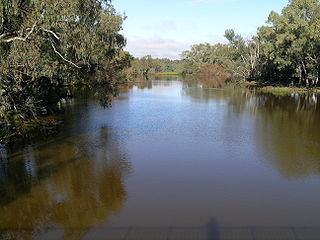
The Macquarie River or Wambuul is part of the Macquarie–Barwon catchment within the Murray–Darling basin, is one of the main inland rivers in New South Wales, Australia.

<span class="mw-page-title-main">Oxley Highway</span> Highway in New South Wales, Australia

Oxley Highway is a rural highway in New South Wales, Australia, linking Nevertire, Gilgandra, Coonabarabran, Tamworth, and Walcha to Port Macquarie, on the coast of the Tasman Sea. It was named to commemorate John Oxley, the first European to explore much of inland New South Wales in 1818.

<span class="mw-page-title-main">Bogan River</span> River in Australia

Bogan River, a perennial river that is part of the Macquarie–Barwon catchment within the Murray–Darling basin, is located in the central west and Orana regions of New South Wales, Australia.

<span class="mw-page-title-main">Clyde County</span> Cadastral in New South Wales, Australia

Clyde County is one of the 141 cadastral divisions of the Australian state of New South Wales. It is located between the Bogan River and Barwon River in the area between them where they join. This is the area to the south of Brewarrina, as far east as the Carinda area. A very small part of the Macquarie River and Castlereagh River is also part of the boundary in the north-east.

<span class="mw-page-title-main">Ewenmar County</span> Cadastral in New South Wales, Australia

Ewenmar County is one of the 141 cadastral divisions of New South Wales. It is located between the Macquarie River on the west and the Castlereagh River on the east, between Warren and Gilgandra. The name derives from a local Aboriginal word.

<span class="mw-page-title-main">Flinders County</span> Cadastral in New South Wales, Australia

Flinders County is one of the 141 cadastral divisions of New South Wales. It is located to the south west of the Bogan River.

<span class="mw-page-title-main">Gregory County, New South Wales</span> Cadastral in New South Wales, Australia

Gregory County is one of the 141 cadastral divisions of New South Wales. It is bordered by Bogan River in the west, and includes the area to the northeast of Nyngan. It includes the Macquarie Marshes Nature Reserve, and the town of Quambone.

<span class="mw-page-title-main">Kennedy County</span> Cadastral in New South Wales, Australia

Kennedy County is one of the 141 cadastral divisions of New South Wales. It is located to the west of the Bogan River in the area around Tottenham and Tullamore.

<span class="mw-page-title-main">Macquarie County</span> Cadastral in New South Wales, Australia

Macquarie County is one of the 141 cadastral divisions of New South Wales, Australia. It is bordered to the north by the Apsley River, and to the south by the Manning River. It includes Port Macquarie and the area around it.

<span class="mw-page-title-main">Narromine County</span> Cadastral in New South Wales, Australia

Narromine County is one of the 141 cadastral divisions of New South Wales. It is located between the Bogan River on the west and the Macquarie River on the east, in the area around Narromine.

<span class="mw-page-title-main">Terangan, New South Wales</span>

Terangan is a rural locality of Warren Shire and a civil parish of Oxley County, New South Wales, a Cadastral divisions of New South Wales.

<span class="mw-page-title-main">Eilginbah, New South Wales</span> Australian County

Elinginbah, New South Wales is a rural locality of Bogan Shire and a civil parish of Oxley County, New South Wales, a Cadastral divisions of New South Wales.

<span class="mw-page-title-main">Beelban Parish, New South Wales</span> Rural locality

Beelban Parish, New South Wales is a rural locality of Warren Shire and a civil parish of Oxley County, New South Wales, a Cadastral divisions of New South Wales.

Mumblebone, New South Wales is a rural locality of Warren Shire and a civil parish of Gregory County, New South Wales, a Cadastral divisions of New South Wales.

Billabulla, New South Wales is a rural locality of Warren Shire and a civil parish of Gregory County, New South Wales, a Cadastral divisions of New South Wales.

<span class="mw-page-title-main">Beardina Parish, New South Wales</span> Rural Australian town

Beardina Parish, New South Wales is a rural locality of Warren Shire and a civil parish of Oxley County, New South Wales, a Cadastral divisions of New South Wales.

<span class="mw-page-title-main">Dooran Parish, New South Wales</span> Rural locality of Warren Shire and a civil parish of Oxley County, New South Wales

Dooran Parish, New South Wales is a rural locality of Warren Shire and a civil parish of Oxley County, New South Wales, a Cadastral divisions of New South Wales.

<span class="mw-page-title-main">Carual, New South Wales</span> Suburb of Warren Shire, New South Wales, Australia

Carual, New South Wales also known as Carval is a civil parish and rural locality of New South Wales located at 31°37'54.0"S 147°44'04.0"E.

<span class="mw-page-title-main">Egelabra, New South Wales</span> Place in New South Wales, Australia

Egelabra, New South Wales is a civil parish and rural locality of New South Wales located at 31°47′54″S 147°50′04″E.

<span class="mw-page-title-main">Lawson Parish (Oxley County), New South Wales</span>

Lawson Parish is a rural locality of Warren Shire.

References

  1. "Oxley County". Geographical Names Register (GNR) of NSW. Geographical Names Board of New South Wales. OOjs UI icon edit-ltr-progressive.svg