Burnett County, New South Wales

Last updated

Map all coordinates using: OpenStreetMap  
Download coordinates as: KML  ·  GPX
Burnett
New South Wales
Burnett NSW.PNG
Location in New South Wales
Lands administrative divisions around Burnett:
Stapylton Stapylton Arrawatta
Courallie Burnett Arrawatta
Courallie Murchison Arrawatta

Burnett County, New South Wales is one of the 141 Cadastral divisions of New South Wales.

Burnett County was named in honour of James Charles Burnett, surveyor (1815-1854). [1]

James Charles Burnett Australian surveyor

James Charles Burnett (1815—1854) a.k.a. "John" was a surveyor and explorer in New South Wales, Australia. He was the head of the first Survey Office established at Brisbane in 1844.

Parishes

A full list of parishes found within this county; their current LGA and mapping coordinates to the approximate centre of each location is as follows:

Local government in Australia

Local government in Australia is the third tier of government in Australia administered by the states and territories, which in turn are beneath the federal tier. Local government is not mentioned in the Constitution of Australia and two referenda in the 1970s and 1980s to alter the Constitution relating to local government were unsuccessful. Every state government recognises local government in their respective constitutions. Unlike Canada or the United States, there is only one level of local government in each state, with no distinction such as cities and counties.

ParishLGACoordinates
Abercrombie Gwydir Shire 29°12′54″S150°30′04″E / 29.21500°S 150.50111°E / -29.21500; 150.50111 (Abercrombie Parish)
Adams Gwydir Shire 29°39′54″S150°36′04″E / 29.66500°S 150.60111°E / -29.66500; 150.60111 (Adams Parish)
Balfour Gwydir Shire 29°37′54″S150°40′04″E / 29.63167°S 150.66778°E / -29.63167; 150.66778 (Balfour Parish)
Baroma Gwydir Shire 29°09′54″S150°17′04″E / 29.16500°S 150.28444°E / -29.16500; 150.28444 (Baroma Parish)
Bledger Gwydir Shire 29°27′54″S150°23′04″E / 29.46500°S 150.38444°E / -29.46500; 150.38444 (Bledger Parish)
Blue Nobby Inverell Shire 29°58′54″S150°41′04″E / 29.98167°S 150.68444°E / -29.98167; 150.68444 (Blue Nobby Parish)
Bogamildi Gwydir Shire 29°22′54″S150°13′04″E / 29.38167°S 150.21778°E / -29.38167; 150.21778 (Bogamildi Parish)
Boobah Gwydir Shire 29°31′54″S150°37′04″E / 29.53167°S 150.61778°E / -29.53167; 150.61778 (Boobah Parish)
Boyanga Gwydir Shire 29°14′54″S150°20′04″E / 29.24833°S 150.33444°E / -29.24833; 150.33444 (Boyanga Parish)
Bullala Gwydir Shire 29°23′54″S150°20′04″E / 29.39833°S 150.33444°E / -29.39833; 150.33444 (Bullala Parish)
Burnett Inverell Shire 29°33′54″S150°53′04″E / 29.56500°S 150.88444°E / -29.56500; 150.88444 (Burnett Parish)
Clare Gwydir Shire 29°37′54″S150°31′04″E / 29.63167°S 150.51778°E / -29.63167; 150.51778 (Clare Parish)
Codrington Gwydir Shire 29°16′54″S150°42′04″E / 29.28167°S 150.70111°E / -29.28167; 150.70111 (Codrington Parish)
Coolatai Inverell Shire 29°11′54″S150°48′04″E / 29.19833°S 150.80111°E / -29.19833; 150.80111 (Coolatai Parish)
Cox Gwydir Shire 29°11′54″S150°25′04″E / 29.19833°S 150.41778°E / -29.19833; 150.41778 (Cox Parish)
Eales Gwydir Shire 29°29′54″S150°19′04″E / 29.49833°S 150.31778°E / -29.49833; 150.31778 (Eales Parish)
Ellis Gwydir Shire 29°01′54″S150°35′04″E / 29.03167°S 150.58444°E / -29.03167; 150.58444 (Ellis Parish)
Gill Gwydir Shire 29°08′54″S150°27′04″E / 29.14833°S 150.45111°E / -29.14833; 150.45111 (Gill Parish)
Gineroi Gwydir Shire 29°40′54″S150°31′04″E / 29.68167°S 150.51778°E / -29.68167; 150.51778 (Gineroi Parish)
Glenalvon Gwydir Shire 29°21′54″S150°30′04″E / 29.36500°S 150.50111°E / -29.36500; 150.50111 (Glenalvon Parish)
Goalonga Gwydir Shire 29°26′54″S150°30′04″E / 29.44833°S 150.50111°E / -29.44833; 150.50111 (Goalonga Parish)
Goorabil Gwydir Shire 29°17′54″S150°14′04″E / 29.29833°S 150.23444°E / -29.29833; 150.23444 (Goorabil Parish)
Gournama Gwydir Shire 29°20′54″S150°39′04″E / 29.34833°S 150.65111°E / -29.34833; 150.65111 (Gournama Parish)
Gragin Inverell Shire 29°31′54″S150°48′04″E / 29.53167°S 150.80111°E / -29.53167; 150.80111 (Gragin Parish)
Gravesend Gwydir Shire 29°32′54″S150°17′04″E / 29.54833°S 150.28444°E / -29.54833; 150.28444 (Gravesend Parish)
Gugumburra Gwydir Shire 29°24′54″S150°38′04″E / 29.41500°S 150.63444°E / -29.41500; 150.63444 (Gugumburra Parish)
Gullungutta Gwydir Shire 29°29′54″S150°48′04″E / 29.49833°S 150.80111°E / -29.49833; 150.80111 (Gullungutta Parish)
Gunnee Inverell Shire 29°35′54″S150°47′04″E / 29.59833°S 150.78444°E / -29.59833; 150.78444 (Gunnee Parish)
Hadleigh Gwydir Shire 29°33′54″S150°35′04″E / 29.56500°S 150.58444°E / -29.56500; 150.58444 (Hadleigh Parish)
Hollingsworth Gwydir Shire 29°20′54″S150°45′04″E / 29.34833°S 150.75111°E / -29.34833; 150.75111 (Hollingsworth Parish)
Kiga Gwydir Shire 29°05′54″S150°16′04″E / 29.09833°S 150.26778°E / -29.09833; 150.26778 (Kiga Parish)
Mandoe Gwydir Shire 29°10′54″S150°42′04″E / 29.18167°S 150.70111°E / -29.18167; 150.70111 (Mandoe Parish)
Mitchell Gwydir Shire 29°02′54″S150°22′04″E / 29.04833°S 150.36778°E / -29.04833; 150.36778 (Mitchell Parish)
Monsoon Gwydir Shire 29°37′54″S150°16′04″E / 29.63167°S 150.26778°E / -29.63167; 150.26778 (Monsoon Parish)
Murgo Gwydir Shire 29°06′54″S150°21′04″E / 29.11500°S 150.35111°E / -29.11500; 150.35111 (Murgo Parish)
Muscle Gwydir Shire 29°00′54″S150°28′04″E / 29.01500°S 150.46778°E / -29.01500; 150.46778 (Muscle Parish)
Myalla Gwydir Shire 29°32′54″S150°45′04″E / 29.54833°S 150.75111°E / -29.54833; 150.75111 (Myalla Parish)
Nunga Nunga Gwydir Shire 29°26′54″S150°15′04″E / 29.44833°S 150.25111°E / -29.44833; 150.25111 (Nunga Nunga Parish)
Oregon Gwydir Shire 29°28′54″S150°27′04″E / 29.48167°S 150.45111°E / -29.48167; 150.45111 (Oregon Parish)
Ottley Gwydir Shire 29°20′54″S150°50′04″E / 29.34833°S 150.83444°E / -29.34833; 150.83444 (Ottley Parish)
Parkhurst Inverell Shire 29°07′54″S150°47′04″E / 29.13167°S 150.78444°E / -29.13167; 150.78444 (Parkhurst Parish)
Pepperbox Gwydir Shire 29°11′54″S150°37′04″E / 29.19833°S 150.61778°E / -29.19833; 150.61778 (Pepperbox Parish)
Rocky Hole Gwydir Shire 29°17′54″S150°24′04″E / 29.29833°S 150.40111°E / -29.29833; 150.40111 (Rocky Hole Parish)
Russell Inverell Shire 29°20′54″S150°55′04″E / 29.34833°S 150.91778°E / -29.34833; 150.91778 (Russell Parish)
Singapoora Gwydir Shire 29°41′54″S150°24′04″E / 29.69833°S 150.40111°E / -29.69833; 150.40111 (Singapoora Parish)
Stack Gwydir Shire 29°12′54″S150°16′04″E / 29.21500°S 150.26778°E / -29.21500; 150.26778 (Stack Parish)
Stanley Gwydir Shire 29°23′54″S150°30′04″E / 29.39833°S 150.50111°E / -29.39833; 150.50111 (Stanley Parish)
Stephenson Gwydir Shire 29°09′54″S150°33′04″E / 29.16500°S 150.55111°E / -29.16500; 150.55111 (Stephenson Parish)
Strathmore Gwydir Shire 29°22′54″S150°25′04″E / 29.38167°S 150.41778°E / -29.38167; 150.41778 (Strathmore Parish)
Stuart Gwydir Shire 29°18′54″S150°30′04″E / 29.31500°S 150.50111°E / -29.31500; 150.50111 (Stuart Parish)
Tackinbri Gwydir Shire 29°01′54″S150°17′04″E / 29.03167°S 150.28444°E / -29.03167; 150.28444 (Tackinbri Parish)
Tullin Tulla Gwydir Shire 29°04′54″S150°21′04″E / 29.08167°S 150.35111°E / -29.08167; 150.35111 (Tullin Tulla Parish)
Vicars Gwydir Shire 29°29′54″S150°30′04″E / 29.49833°S 150.50111°E / -29.49833; 150.50111 (Vicars Parish)
Warialda Gwydir Shire 29°32′54″S150°34′04″E / 29.54833°S 150.56778°E / -29.54833; 150.56778 (Warialda Parish)
Yagobe Gwydir Shire 29°29′54″S150°14′04″E / 29.49833°S 150.23444°E / -29.49833; 150.23444 (Yagobe Parish)
Yallaroi Gwydir Shire 29°04′54″S150°32′04″E / 29.08167°S 150.53444°E / -29.08167; 150.53444 (Yallaroi Parish)
Yallaroi Gwydir Shire 29°04′54″S150°29′04″E / 29.08167°S 150.48444°E / -29.08167; 150.48444 (Yallaroi Parish)

Related Research Articles

Burnett may refer to:

South Creek (New South Wales) river in New South Wales, Australia

The South Creek or Wianamatta, a creek that is part of the Hawkesbury-Nepean catchment, is located on the Cumberland Plain, also referred to as Greater Western Sydney, New South Wales, Australia.

The Geographical Names Board of New South Wales, a statutory authority of the Land and Property Information division, Department of Finance and Services in the Government of New South Wales, is the official body for naming and recording details of places and geographical names in the state of New South Wales, Australia.

Regions of Queensland geographic areas of Queensland, Australia

The Regions of Queensland refer to the geographic areas of the Australian state of Queensland. Due to its large size and decentralised population, the state is often divided into regions for statistical and administrative purposes. Each region varies somewhat in terms of its economy, population, climate, geography, flora and fauna. Cultural and official perceptions and definitions of the various regions differ somewhat depending on the government agency or popular group by which they are being applied.

Darbalara, New South Wales Town in New South Wales, Australia

Darbalara is a rural community on the east bank of the junction of the Murrumbidgee River and Tumut River in the Riverina. It is situated by road, about 25 kilometres north east of Gundagai and 25 kilometres south of Coolac.

Burnett, Washington Unincorporated community in Washington, United States

Burnett is an unincorporated community in Pierce County, Washington, United States. It is located just south of Buckley, Washington. It is on State Route 165 between Buckley, Washington and Mt. Rainier National Park. It is located at 47°7′45.98″N122°2′52.01″W.

Gloucester County, New South Wales Cadastral in New South Wales, Australia

Gloucester County was one of the original Nineteen Counties in New South Wales, and is now one of the 141 cadastral divisions of New South Wales. It includes the area around Port Stephens. It is bounded on the north and west by the Manning River, and on the south-west by the Williams River.

Camden County, New South Wales Cadastral in New South Wales, Australia

Camden County was one of the original Nineteen Counties in New South Wales and is now one of the 141 Cadastral divisions of New South Wales. It included the coastal area near Wollongong south to the Shoalhaven River, and also inland encompassing Berrima and Picton. Its western boundary was the Wollondilly River. The first settlement in the area was Camden Park, established by John Macarthur in 1806, just across the Nepean River from Cumberland County. It was the first land across the Nepean to be settled. Camden is a present-day suburb of Sydney in the same area, although parts of it are in Cumberland.

St Vincent County Cadastral in Australian Capital Territory

St Vincent County was one of the original Nineteen Counties in New South Wales and is now one of the 141 Cadastral divisions of New South Wales. It included the south coast area encompassing Batemans Bay, Ulladulla, Jervis Bay and inland to Braidwood. The Shoalhaven River is the boundary to the north and west, and the Deua River the boundary to the south.

Cowper County Cadastral in New South Wales, Australia

Cowper County, New South Wales is one of the 141 Cadastral divisions of New South Wales.

Mootwingee County Cadastral in New South Wales, Australia

Mootwingee County, New South Wales is one of the 141 Cadastral divisions of New South Wales.

Oxley County Cadastral in New South Wales, Australia

Oxley County, New South Wales is one of the 141 Cadastral divisions of New South Wales. It is located between the Bogan River on the west, and the Macquarie River on the east. This is the area approximately between Warren and Nyngan.

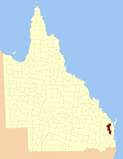
Moreton, Wide Bay, Burnett and Maranoa, and from 1857 Moreton, Wide Bay, Burnett, Maranoa, Leichhardt and Port Curtis, was an electoral district of the Legislative Assembly in the Australian state of New South Wales created in 1856 and consisted of the pastoral districts around the early settlements of Moreton Bay; Wide Bay, near Maryborough; the Burnett River, near Bundaberg; and the Maranoa region of South-western Queensland. In September 1856 the pastoral districts around the Leichhardt River in the Gulf of Carpentaria region and Port Curtis (Gladstone) were added to the electorate. The district was abolished for the 1859 election and replaced by the separate districts of East Moreton, West Moreton, Burnett and Leichhardt, while Maranoa became part of Darling Downs. All of these districts became part of Queensland when it was established as a separate colony in late 1859.

Burnett, Minnesota Unincorporated community in Minnesota, United States

Burnett is an unincorporated community in Industrial Township, Saint Louis County, Minnesota, United States.

Burnett (CDP), Wisconsin Census-designated place in Wisconsin, United States

Burnett is an unincorporated census-designated place located in the town of Burnett, Dodge County, Wisconsin, United States. Burnett is located on Wisconsin Highway 26 5.5 miles (8.9 km) northwest of Horicon. Burnett has a post office with ZIP code 53922. As of the 2010 census, its population is 256.

County of Fitzroy, Queensland Cadastral in Queensland, Australia

The County of Fitzroy is a county in Queensland, Australia. Like all counties in Queensland, it is a non-functional administrative unit, that is used mainly for the purpose of registering land titles.

Gaslyn, Wisconsin Unincorporated community in Wisconsin, United States

Gaslyn is an unincorporated community in the town of Rusk, Burnett County, Wisconsin, United States. Gaslyn is located along County Highway H to the south of Gaslyn Lake. The community is part of the reservation of the St. Croix Chippewa Indians of Wisconsin. The community was named for David C. Gaslin, a logger during the 1860s. A post office operated in the community from 1902 to 1919.

Blowering, New South Wales

Blowering, New South wales is a rural locality in the Snowy Mountains of New South wales and a civil Parish of Buccleuch County.

The Electoral district of Pastoral Districts of Moreton, Wide Bay, Burnett, and Maranoa was an electorate of the New South Wales Legislative Council at a time when some of its members were elected and the balance were appointed by the Governor. It was a new electorate created in 1851 by the expansion of the Legislative Council to 54, 18 to be appointed and 36 elected. The district was named after the early settlements of Moreton Bay; Wide Bay, near Maryborough; the Burnett River, near Bundaberg; the Maranoa region of South-western Queensland. These became part of Queensland on its establishment in 1859.

References

  1. "Burnett County". Geographical Names Register (GNR) of NSW. Geographical Names Board of New South Wales. OOjs UI icon edit-ltr-progressive.svg