Barrona County

Last updated

Map all coordinates using: OpenStreetMap  
Download coordinates as: KML  ·  GPX
Barrona
New South Wales
Barrona NSW.PNG
Location in New South Wales
Lands administrative divisions around Barrona:
Thoulcanna Irrara Gunderbooka
Ularara Barrona Gunderbooka
Fitzgerald Landsborough Gunderbooka

Barrona County is one of the 141 Cadastral divisions of New South Wales. It is bounded by the Warrego River in the east and the Paroo River in the west.

Warrego River river in Australia

The Warrego River, an intermittent river that is part of the Darling catchment within the Murray–Darling basin, is located in the south west of Queensland and in the Orana region of New South Wales, Australia. The Warrego River is northernmost tributary of the Darling River.

Paroo River river in Queensland and New South Wales, Australia

The Paroo River, a series of waterholes, connected in wet weather as a running stream of the Darling catchment within the Murray–Darling basin, is located in the South West region of Queensland and Far West region of New South Wales, Australia. It is the home of the Paarkantji people.

Barrona is believed to be derived from a local Aboriginal word and the nearby Barrona Downs also carries that Aboriginal name. [1]

Indigenous Australians are the Aboriginal and Torres Strait Islander peoples of Australia, descended from groups that existed in Australia and surrounding islands before British colonisation. The time of arrival of the first Indigenous peoples on the continent and nearby islands is a matter of debate among researchers. The earliest conclusively human remains found in Australia are those of Mungo Man LM3 and Mungo Lady, which have been dated to around 50,000 years BP. Recent archaeological evidence from the analysis of charcoal and artefacts revealing human use suggests a date as early as 65,000 BP. Luminescence dating has suggested habitation in Arnhem Land as far back as 60,000 years BP. Genetic research has inferred a date of habitation as early as 80,000 years BP. Other estimates have ranged up to 100,000 years and 125,000 years BP.

Parishes within this county

A full list of parishes found within this county; their current LGA and mapping coordinates to the approximate centre of each location is as follows:

Local government in Australia

Local government in Australia is the third tier of government in Australia administered by the states and territories, which in turn are beneath the federal tier. Local government is not mentioned in the Constitution of Australia and two referenda in the 1970s and 1980s to alter the Constitution relating to local government were unsuccessful. Every state government recognises local government in their respective constitutions. Unlike Canada or the United States, there is only one level of local government in each state, with no distinction such as cities and counties.

ParishLGACoordinates
Ballycastle Bourke Shire 30°02′43″S145°02′45″E / 30.04528°S 145.04583°E / -30.04528; 145.04583 (Ballycastle Parish)
Blarney Bourke Shire 30°00′44″S144°55′08″E / 30.01222°S 144.91889°E / -30.01222; 144.91889 (Blarney Parish)
Buntiara Bourke Shire 29°52′54″S144°26′25″E / 29.88167°S 144.44028°E / -29.88167; 144.44028 (Buntiara Parish)
Byjerk Unincorporated 30°06′38″S144°09′03″E / 30.11056°S 144.15083°E / -30.11056; 144.15083 (Byjerk Parish)
Cahirnane Bourke Shire 30°08′08″S144°24′23″E / 30.13556°S 144.40639°E / -30.13556; 144.40639 (Cahirnane Parish)
Coorallie Bourke Shire 30°03′52″S144°12′57″E / 30.06444°S 144.21583°E / -30.06444; 144.21583 (Coorallie Parish)
Curragh Bourke Shire 29°46′45″S145°15′09″E / 29.77917°S 145.25250°E / -29.77917; 145.25250 (Curragh Parish)
Dargle Bourke Shire 29°55′24″S144°49′05″E / 29.92333°S 144.81806°E / -29.92333; 144.81806 (Dargle Parish)
Effluence Bourke Shire unknown
Gleena Bourke Shire 30°02′12″S144°25′13″E / 30.03667°S 144.42028°E / -30.03667; 144.42028 (Gleena Parish)
Goombalie Bourke Shire 30°05′54″S145°21′31″E / 30.09833°S 145.35861°E / -30.09833; 145.35861 (Goombalie Parish)
Goonery Bourke Shire 30°06′47″S145°07′28″E / 30.11306°S 145.12444°E / -30.11306; 145.12444 (Goonery Parish)
Kulkyne Bourke Shire 29°49′06″S144°34′53″E / 29.81833°S 144.58139°E / -29.81833; 144.58139 (Kulkyne Parish)
Longside Bourke Shire 30°07′25″S144°36′35″E / 30.12361°S 144.60972°E / -30.12361; 144.60972 (Longside Parish)
Maghera Bourke Shire 29°55′09″S145°03′43″E / 29.91917°S 145.06194°E / -29.91917; 145.06194 (Maghera Parish)
Mere Bourke Shire 30°15′20″S145°03′12″E / 30.25556°S 145.05333°E / -30.25556; 145.05333 (Mere Parish)
Merrita South Bourke Shire 29°49′04″S145°06′15″E / 29.81778°S 145.10417°E / -29.81778; 145.10417 (Merrita South Parish)
Merrita West Bourke Shire 29°51′30″S144°56′57″E / 29.85833°S 144.94917°E / -29.85833; 144.94917 (Merrita West Parish)
Nummo Bourke Shire 30°07′37″S144°17′07″E / 30.12694°S 144.28528°E / -30.12694; 144.28528 (Nummo Parish)
Otako Bourke Shire 29°58′32″S144°34′49″E / 29.97556°S 144.58028°E / -29.97556; 144.58028 (Otako Parish)
Paroo Bourke Shire unknown
Round Hill Bourke Shire 29°58′37″S145°13′32″E / 29.97694°S 145.22556°E / -29.97694; 145.22556 (Round Hill Parish)
Tantawanga Bourke Shire 29°48′59″S144°14′55″E / 29.81639°S 144.24861°E / -29.81639; 144.24861 (Tantawanga Parish)
Uteeara Bourke Shire 30°10′47″S145°15′58″E / 30.17972°S 145.26611°E / -30.17972; 145.26611 (Uteeara Parish)
Wanga Bourke Shire 29°45′42″S144°45′09″E / 29.76167°S 144.75250°E / -29.76167; 144.75250 (Wanga Parish)
Wentworth Bourke Shire 30°05′44″S144°46′09″E / 30.09556°S 144.76917°E / -30.09556; 144.76917 (Wentworth Parish)
Winnalabrinna Bourke Shire 29°47′51″S145°22′30″E / 29.79750°S 145.37500°E / -29.79750; 145.37500 (Winnalabrinna Parish)
Yandaroo Bourke Shire 30°04′48″S145°14′03″E / 30.08000°S 145.23417°E / -30.08000; 145.23417 (Yandaroo Parish)

Related Research Articles

Barwon River (New South Wales) river located in the Orana region of New South Wales, Australia

Barwon River, a perennial river that is part of the Murray–Darling basin, is located in the north-west slopes and Orana regions of New South Wales, Australia.

South Creek (New South Wales) river in New South Wales, Australia

The South Creek or Wianamatta, a creek that is part of the Hawkesbury-Nepean catchment, is located on the Cumberland Plain, also referred to as Greater Western Sydney, New South Wales, Australia.

The Geographical Names Board of New South Wales, a statutory authority of the Land and Property Information division, Department of Finance and Services in the Government of New South Wales, is the official body for naming and recording details of places and geographical names in the state of New South Wales, Australia.

Yass River river in New South Wales, Australia

The Yass River, a perennial river that is part of the Murrumbidgee catchment within the Murray–Darling basin, is located in the Southern Tablelands and South Western Slopes districts of New South Wales, Australia.

Ewenmar County Cadastral in New South Wales, Australia

Ewenmar County is one of the 141 Cadastral divisions of New South Wales. It is located between the Macquarie River on the west, and the Castlereagh River on the east. This is the area between Warren and Gilgandra.

Gunderbooka County Cadastral in New South Wales, Australia

Gunderbooka County is one of the 141 Cadastral divisions of New South Wales. The Warrego River is the western boundary, and the Culgoa River and Darling River is the south-eastern boundary. It includes the area down to where the Warrego meets the Darling, to the north of Bourke.

Irrara County Cadastral in New South Wales, Australia

Irrara County is one of the 141 Cadastral divisions of New South Wales. It is located south of the border with Queensland, east of the Paroo River, and west of the Warrego River.

Killara County Cadastral in New South Wales, Australia

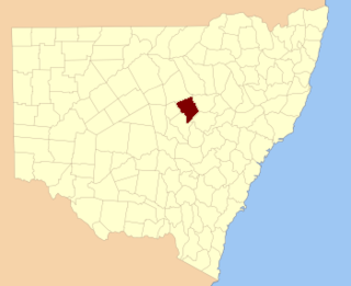
Killara County is one of the 141 Cadastral divisions of New South Wales. The Darling River is its south eastern boundary.

Narran County Cadastral in New South Wales, Australia

Narran County is one of the 141 Cadastral divisions of New South Wales. It is bounded by the Culgoa River on the west, the Narran River in the east, the Queensland border in the north, and the Barwon River in the south. It includes Goodooga and the area to the north of Brewarrina.

Narromine County Cadastral in New South Wales, Australia

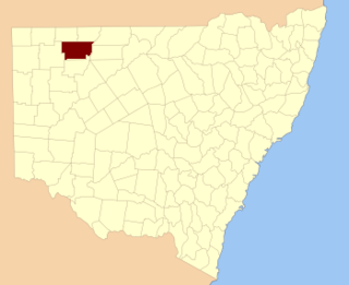
Narromine County is one of the 141 Cadastral divisions of New South Wales. It is located between the Bogan River on the west and the Macquarie River on the east, in the area around Narromine.

Thoulcanna County Cadastral in New South Wales, Australia

Thoulcanna County is one of the 141 Cadastral divisions of New South Wales. It is located south of the border with Queensland, to the west of the Paroo River near Wanaaring in the Bourke Shire.

Ularara County Cadastral in New South Wales, Australia

Ularara County is one of the 141 Cadastral divisions of New South Wales. It is located to the west of the Paroo River.

Aberfoyle River

Aberfoyle River, a watercourse that is part of the Clarence River catchment, is located in the New England and Northern Tablelands districts of New South Wales, Australia.

Boorowa River

Boorowa River, a perennial stream that is part of the Lachlan catchment within the Murray–Darling basin, is located in the central–western region of New South Wales, Australia.

Dingo Creek, a perennial stream of the Manning River catchment, is located in the Mid North Coast region of New South Wales, Australia.

Berrima River

The Berrima River, also called the Berrima Creek, is a perennial river of the Snowy River catchment, located in the Alpine region of the Australian states of New South Wales and Victoria.

Effluence, New South wales Town in New South Wales, Australia

Effluence, New South Wales is a remote rural locality of Bourke Shire, New South wales.

Coorallie is a remote civil Parish, of the County of Barrona, a cadasteral division of New South Wales.

Tantawanga (Barrona County parish)

Tantawanga Parish is a remote civil Parish, of the County of Barrona, a cadasteral division of New South Wales.

Byjerk Parish is a remote civil Parish, of the County of Barrona, a cadasteral division of New South Wales.

References

  1. "Barrona County". Geographical Names Register (GNR) of NSW. Geographical Names Board of New South Wales. OOjs UI icon edit-ltr-progressive.svg