Werunda County

Last updated

Map all coordinates using: OpenStreetMap  
Download coordinates as: KML  ·  GPX
Werunda
New South Wales
Werunda NSW.PNG
Location in New South Wales
Lands administrative divisions around Werunda:
Young Killara Rankin
Young Werunda Rankin
Livingstone Woore Woore

Werunda County is one of the 141 Cadastral divisions of New South Wales. The Darling River is the north-western boundary. It includes Poopelloe Lake, and the area to the east and south-east of Wilcannia.

Darling River river in Australia

The Darling River is the third longest river in Australia, measuring 1,472 kilometres (915 mi) from its source in northern New South Wales to its confluence with the Murray River at Wentworth, New South Wales. Including its longest contiguous tributaries it is 2,844 km (1,767 mi) long, making it the longest river system in Australia.

Wilcannia Town in New South Wales, Australia

Wilcannia is a small town located within the Central Darling Shire in north western New South Wales, Australia. This was the third largest inland port in the country during the great river boat era of the mid-19th century. At the 2016 census, Wilcannia had a population of 549.

The name Werunda is believed to be derived from a local Aboriginal word. [1]

Indigenous Australians are the Aboriginal and Torres Strait Islander peoples of Australia, descended from groups that existed in Australia and surrounding islands before British colonisation. The time of arrival of the first Indigenous peoples on the continent and nearby islands is a matter of debate among researchers. The earliest conclusively human remains found in Australia are those of Mungo Man LM3 and Mungo Lady, which have been dated to around 50,000 years BP. Recent archaeological evidence from the analysis of charcoal and artefacts revealing human use suggests a date as early as 65,000 BP. Luminescence dating has suggested habitation in Arnhem Land as far back as 60,000 years BP. Genetic research has inferred a date of habitation as early as 80,000 years BP. Other estimates have ranged up to 100,000 years and 125,000 years BP.

Parishes within this county

A full list of parishes found within this county; their current LGA and mapping coordinates to the approximate centre of each location is as follows:

Local government in Australia

Local government in Australia is the third tier of government in Australia administered by the states and territories, which in turn are beneath the federal tier. Local government is not mentioned in the Constitution of Australia and two referenda in the 1970s and 1980s to alter the Constitution relating to local government were unsuccessful. Every state government recognises local government in their respective constitutions. Unlike Canada or the United States, there is only one level of local government in each state, with no distinction such as cities and counties.

Map of Werunda County, Far west New South Wales from John Sands 1886 Atlas of Australia. Werunda, John Sands 1886 map.png
Map of Werunda County, Far west New South Wales from John Sands 1886 Atlas of Australia.
ParishLGACoordinates
Calcoo Central Darling Shire 31°39′10″S143°35′22″E / 31.65278°S 143.58944°E / -31.65278; 143.58944 (Calcoo)
Caltigeenaa Central Darling Shire 31°34′55″S143°52′00″E / 31.58194°S 143.86667°E / -31.58194; 143.86667 (Caltigeenaa)
Chance Central Darling Shire 31°30′13″S144°04′53″E / 31.50361°S 144.08139°E / -31.50361; 144.08139 (Chance)
Chirnside Central Darling Shire 31°57′38″S143°45′13″E / 31.96056°S 143.75361°E / -31.96056; 143.75361 (Chirnside)
Coolmara Central Darling Shire 32°05′22″S143°49′30″E / 32.08944°S 143.82500°E / -32.08944; 143.82500 (Coolmara)
Coonavittra Central Darling Shire 31°43′05″S144°18′23″E / 31.71806°S 144.30639°E / -31.71806; 144.30639 (Coonavittra)
Coonoolcra Central Darling Shire 31°47′18″S143°35′16″E / 31.78833°S 143.58778°E / -31.78833; 143.58778 (Coonoolcra)
Cowary Central Darling Shire unknown
Cultowa Central Darling Shire 31°53′50″S144°05′40″E / 31.89722°S 144.09444°E / -31.89722; 144.09444 (Cultowa)
Curranyale Central Darling Shire unknown
Donald Cobar Shire 31°50′34″S144°20′34″E / 31.84278°S 144.34278°E / -31.84278; 144.34278 (Donald)
Dunoon Central Darling Shire 31°31′41″S143°37′36″E / 31.52806°S 143.62667°E / -31.52806; 143.62667 (Dunoon)
Goonalgaa Central Darling Shire 31°45′50″S143°41′28″E / 31.76389°S 143.69111°E / -31.76389; 143.69111 (Goonalgaa)
Greenough Central Darling Shire 31°34′29″S144°13′15″E / 31.57472°S 144.22083°E / -31.57472; 144.22083 (Greenough)
Gunyulka Central Darling Shire 31°41′55″S143°29′55″E / 31.69861°S 143.49861°E / -31.69861; 143.49861 (Gunyulka)
Keiss Central Darling Shire 31°30′51″S143°44′26″E / 31.51417°S 143.74056°E / -31.51417; 143.74056 (Keiss)
Manara Central Darling Shire 32°11′23″S143°50′39″E / 32.18972°S 143.84417°E / -32.18972; 143.84417 (Manara)
Merry Central Darling Shire 31°25′16″S144°01′55″E / 31.42111°S 144.03194°E / -31.42111; 144.03194 (Merry)
Moira Central Darling Shire 31°52′54″S143°54′57″E / 31.88167°S 143.91583°E / -31.88167; 143.91583 (Moira)
Murtee Central Darling Shire 31°36′34″S143°31′26″E / 31.60944°S 143.52389°E / -31.60944; 143.52389 (Murtee)
Paradise Central Darling Shire 31°59′18″S143°51′37″E / 31.98833°S 143.86028°E / -31.98833; 143.86028 (Paradise)
Poopelloe Central Darling Shire 31°40′14″S144°09′22″E / 31.67056°S 144.15611°E / -31.67056; 144.15611 (Poopelloe)
Ringrose Central Darling Shire 32°02′43″S144°01′15″E / 32.04528°S 144.02083°E / -32.04528; 144.02083 (Ringrose)
Talyawalka Central Darling Shire 31°35′48″S143°41′28″E / 31.59667°S 143.69111°E / -31.59667; 143.69111 (Talyawalka)
Warwick Cobar Shire 31°56′19″S144°01′33″E / 31.93861°S 144.02583°E / -31.93861; 144.02583 (Warwick)
Weatherley Central Darling Shire 31°45′37″S143°51′16″E / 31.76028°S 143.85444°E / -31.76028; 143.85444 (Weatherley)
Weeyoola Central Darling Shire 31°46′05″S144°09′13″E / 31.76806°S 144.15361°E / -31.76806; 144.15361 (Weeyoola)
Werunda Central Darling Shire 31°29′34″S143°50′56″E / 31.49278°S 143.84889°E / -31.49278; 143.84889 (Werunda)
Wilcannia South Central Darling Shire 31°36′12″S143°23′41″E / 31.60333°S 143.39472°E / -31.60333; 143.39472 (Wilcannia South)
Wongolarroo Central Darling Shire 31°39′11″S143°57′20″E / 31.65306°S 143.95556°E / -31.65306; 143.95556 (Wongolarroo)
Woore Cobar Shire unknown
Woytchugga Central Darling Shire 31°43′17″S143°23′13″E / 31.72139°S 143.38694°E / -31.72139; 143.38694 (Woytchugga)
Yoree Central Darling Shire 31°44′13″S144°01′56″E / 31.73694°S 144.03222°E / -31.73694; 144.03222 (Yoree)

Related Research Articles

The Geographical Names Board of New South Wales, a statutory authority of the Land and Property Information division, Department of Finance and Services in the Government of New South Wales, is the official body for naming and recording details of places and geographical names in the state of New South Wales, Australia.

Darbalara, New South Wales Town in New South Wales, Australia

Darbalara is a rural community on the east bank of the junction of the Murrumbidgee River and Tumut River in the Riverina. It is situated by road, about 25 kilometres north east of Gundagai and 25 kilometres south of Coolac.

Durham County, New South Wales Cadastral in New South Wales, Australia

Durham County was one of the original Nineteen Counties in New South Wales and is now one of the 141 Cadastral divisions of New South Wales. It is bordered on the south and west by the Hunter River, and on the north and east by the Williams River. It includes Aberdeen and Muswellbrook. Before 1834, the area known as Durham County included what later became Gloucester and most of Brisbane counties, as far west as the Liverpool Range, and east to the Pacific, including Port Stephens, as shown on an 1832 map.

Argyle County Cadastral in New South Wales, Australia

Argyle County was one of the original Nineteen Counties in New South Wales and is now one of the 141 Cadastral divisions of New South Wales. It includes the area around Goulburn. It is bounded by Lake George in the south-west, the Shoalhaven River in the east, and the Wollondilly River in the north-east.

Roxburgh County Cadastral in New South Wales, Australia

Roxburgh County was one of the original Nineteen Counties in New South Wales and is now one of the 141 Cadastral divisions of New South Wales. It includes the area to the north east of Bathurst, lying to the north and east of the Fish River to the junction of the Turon River. It includes Sofala. The Gudgegong River is the border to the north.

Cowper County Cadastral in New South Wales, Australia

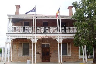
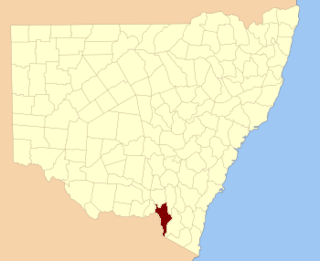
Cowper County, New South Wales is one of the 141 Cadastral divisions of New South Wales.

Gowen County Cadastral in New South Wales, Australia

Gowen County is one of the 141 Cadastral divisions of New South Wales. It is located to the east of the Castlereagh River in the area to the east of Gilgandra, to Coonabarabran in the north-east. This includes land on both sides of the Newell Highway.

Irrara County Cadastral in New South Wales, Australia

Irrara County is one of the 141 Cadastral divisions of New South Wales. It is located south of the border with Queensland, east of the Paroo River, and west of the Warrego River.

Oxley County Cadastral in New South Wales, Australia

Oxley County, New South Wales is one of the 141 Cadastral divisions of New South Wales. It is located between the Bogan River on the west, and the Macquarie River on the east. This is the area approximately between Warren and Nyngan.

Selwyn County, New South Wales Cadastral in New South Wales, Australia

Selwyn County is one of the 141 Cadastral divisions of New South Wales. It is located to the east of the Murray River, with part of the Tumut River as its boundary to the north-east. It includes Mount Kosciuszko, the highest mountain in Australia.

Dangarsleigh, New South Wales Town in New South Wales, Australia

Dangarsleigh is a rural locality and minor trigonometrical station about 11 km south east of Armidale, New South Wales. The locality is at an altitude of about 1,020 metres on the Northern Tablelands in the New England region of New South Wales, Australia. The name Dangarsleigh commemorates the surveyor and pastoralist Henry Dangar’s name. It is within the Armidale Regional Council local government area and Sandon County.

The Bemboka River, a perennial stream of the Bega River catchment, is located in the Monaro and South Coast regions of New South Wales, Australia.

Bendoc River

The Bendoc River is a perennial river of the Snowy River catchment, located in the Alpine regions of the states of Victoria and New South Wales, Australia.

Cobrabald River

Cobrabald River, a mostly perennial river that is part of the Namoi catchment within the Murray–Darling basin, is located in the Northern Tablelands district of New South Wales, Australia.

Genoa River

Genoa River is a perennial river located in the Monaro region of New South Wales and flows into the East Gippsland region of Victoria in Australia. It used to be known as Bondi Creek or Yard Creek. The river's name derives from the First People "jinoor" ("footpath").

Phils River river in Australia

Phils River, a watercourse that is part of the Lachlan catchment within the Murray–Darling basin, is located in the central western region of New South Wales, Australia.

Wadbilliga River river in New South Wales, Australia

The Wadbilliga River is a perennial stream of the Tuross River catchment that is located in the South Coast region of New South Wales, Australia.

Wallagaraugh River river in Victoria, Australia

The Wallagaraugh River is a perennial river of the Genoa River catchment, with its headwaters located in the South Coast region of New South Wales and its lower reaches located in the East Gippsland region of Victoria, Australia.

Sandy Creek (Richmond Valley) river in Australia

The Sandy Creek, a perennial stream of the Richmond River catchment, is located in Northern Rivers region in the state of New South Wales, Australia.

The Clouds Creek, a perennial stream that is part of the Clarence River catchment, is located in the Northern Tablelands region of New South Wales, Australia.

References

  1. "Werunda County". Geographical Names Register (GNR) of NSW. Geographical Names Board of New South Wales. OOjs UI icon edit-ltr-progressive.svg