Waradgery County

Last updated

Map all coordinates using: OpenStreetMap  
Download coordinates as: KML  ·  GPX
Waradgery
New South Wales
Waradgery NSW.PNG
Location in New South Wales
Lands administrative divisions around Waradgery:
Caira Waljeers Nicholson
Caira Waradgery Sturt
Wakool Townsend Boyd

Waradgery County is one of the 141 Cadastral divisions of New South Wales. It contains the town of Hay. It includes the area between the Lachlan River and the Murrumbidgee River where they meet. The Lachlan River is the northern boundary of the county, and the Murrumbidgee for a small section is the southern boundary, but the county also includes some of the land to the south of the Murrumbidgee near Hay.

Hay, New South Wales Town in New South Wales, Australia

Hay is a town in the western Riverina region of south western New South Wales, Australia. It is the administrative centre of Hay Shire local government area and the centre of a prosperous and productive agricultural district on the wide Hay Plains.

Lachlan River tributary to the Murrumbidgee River in New South Wales, Australia

The Lachlan River is an intermittent river that is part of the Murrumbidgee catchment within the Murray–Darling basin, located in the Southern Tablelands, Central West, and Riverina regions of New South Wales, Australia.

Murrumbidgee River river in New South Wales, Australia

Murrumbidgee River, a major tributary of the Murray River within the Murray–Darling basin and the second longest river in Australia. It flows through the Australian state of New South Wales and the Australian Capital Territory. It descends 1,500 metres (4,900 ft) as it flows 1,485 kilometres (923 mi) in a west-northwesterly direction from the foot of Peppercorn Hill in the Fiery Range of the Snowy Mountains towards its confluence with the Murray River near Boundary Bend.

The name Waradgery is believed to be derived from a local Aboriginal word (probably in relation to the Wiradjuri people. [1]

Indigenous Australians are the Aboriginal and Torres Strait Islander peoples of Australia, descended from groups that existed in Australia and surrounding islands before British colonisation. The time of arrival of the first Indigenous peoples on the continent and nearby islands is a matter of debate among researchers. The earliest conclusively human remains found in Australia are those of Mungo Man LM3 and Mungo Lady, which have been dated to around 50,000 years BP. Recent archaeological evidence from the analysis of charcoal and artefacts revealing human use suggests a date as early as 65,000 BP. Luminescence dating has suggested habitation in Arnhem Land as far back as 60,000 years BP. Genetic research has inferred a date of habitation as early as 80,000 years BP. Other estimates have ranged up to 100,000 years and 125,000 years BP.

The Wiradjuri people are a group of Indigenous Australian Aboriginal people that were united by a common language, strong ties of kinship and survived as skilled hunter–fisher–gatherers in family groups or clans scattered throughout central New South Wales.

Parishes within this county

Wajadgery County NSW as shown on John Sands' 1886 map Waradgery County (John Sands 1886 map).png
Wajadgery County NSW as shown on John Sands' 1886 map

A full list of parishes found within this county; their current LGA and mapping coordinates to the approximate centre of each location is as follows:

Local government in Australia

Local government in Australia is the third tier of government in Australia administered by the states and territories, which in turn are beneath the federal tier. Local government is not mentioned in the Constitution of Australia and two referenda in the 1970s and 1980s to alter the Constitution relating to local government were unsuccessful. Every state government recognises local government in their respective constitutions. Unlike Canada or the United States, there is only one level of local government in each state, with no distinction such as cities and counties.

ParishLGACoordinates
Abercrombie Hay Shire Council 34°38′54″S144°41′04″E / 34.64833°S 144.68444°E / -34.64833; 144.68444 (Abercrombie Parish)
Beabula Hay Shire Council 34°29′54″S145°10′04″E / 34.49833°S 145.16778°E / -34.49833; 145.16778 (Beabula Parish)
Bedarbidgal Hay Shire Council 34°47′54″S145°08′04″E / 34.79833°S 145.13444°E / -34.79833; 145.13444 (Bedarbidgal Parish)
Benduck North Hay Shire Council 34°25′54″S144°35′04″E / 34.43167°S 144.58444°E / -34.43167; 144.58444 (Benduck North Parish)
Benduck South Hay Shire Council 34°30′54″S144°36′04″E / 34.51500°S 144.60111°E / -34.51500; 144.60111 (Benduck South Parish)
Beresford Hay Shire Council 34°44′54″S144°47′04″E / 34.74833°S 144.78444°E / -34.74833; 144.78444 (Beresford Parish)
Boyong Hay Shire Council 34°20′54″S144°02′04″E / 34.34833°S 144.03444°E / -34.34833; 144.03444 (Boyong Parish)
Brush Hay Shire Council 34°36′54″S145°00′04″E / 34.61500°S 145.00111°E / -34.61500; 145.00111 (Brush Parish)
Budgee Hay Shire Council 34°21′54″S144°19′04″E / 34.36500°S 144.31778°E / -34.36500; 144.31778 (Budgee Parish)
Burrabogie Hay Shire Council 34°33′54″S145°11′04″E / 34.56500°S 145.18444°E / -34.56500; 145.18444 (Burrabogie Parish)
Chambers Hay Shire Council 34°47′54″S144°00′04″E / 34.79833°S 144.00111°E / -34.79833; 144.00111 (Chambers Parish)
Cluny Hay Shire Council 34°20′54″S144°36′04″E / 34.34833°S 144.60111°E / -34.34833; 144.60111 (Cluny Parish)
Coonoon Hay Shire Council 34°29′54″S144°30′04″E / 34.49833°S 144.50111°E / -34.49833; 144.50111 (Coonoon Parish)
Cuba Hay Shire Council 34°47′54″S144°55′04″E / 34.79833°S 144.91778°E / -34.79833; 144.91778 (Cuba Parish)
Darcoola Hay Shire Council 34°21′54″S144°28′04″E / 34.36500°S 144.46778°E / -34.36500; 144.46778 (Darcoola Parish)
Dowling Hay Shire Council 34°13′54″S144°24′04″E / 34.23167°S 144.40111°E / -34.23167; 144.40111 (Dowling Parish)
East Waradgery Hay Shire Council 34°29′54″S144°54′04″E / 34.49833°S 144.90111°E / -34.49833; 144.90111 (East Waradgery Parish)
Eli Elwah Hay Shire Council 34°32′54″S144°58′04″E / 34.54833°S 144.96778°E / -34.54833; 144.96778 (Eli Elwah Parish)
Eurolie Hay Shire Council 34°44′54″S145°09′04″E / 34.74833°S 145.15111°E / -34.74833; 145.15111 (Eurolie Parish)
Gelam Hay Shire Council 34°21′54″S144°11′04″E / 34.36500°S 144.18444°E / -34.36500; 144.18444 (Gelam Parish)
Godfrey Hay Shire Council 34°44′54″S144°34′04″E / 34.74833°S 144.56778°E / -34.74833; 144.56778 (Godfrey Parish)
Grant Hay Shire Council 34°14′54″S145°06′04″E / 34.24833°S 145.10111°E / -34.24833; 145.10111 (Grant Parish)
Gre Gre Hay Shire Council 34°37′54″S144°30′04″E / 34.63167°S 144.50111°E / -34.63167; 144.50111 (Gre Gre Parish)
Hay South Hay Shire Council 34°32′54″S144°52′04″E / 34.54833°S 144.86778°E / -34.54833; 144.86778 (Hay South Parish)
Hay Hay Shire Council 34°29′54″S144°50′04″E / 34.49833°S 144.83444°E / -34.49833; 144.83444 (Hay Parish)
Hiawatha Hay Shire Council 34°11′54″S144°49′04″E / 34.19833°S 144.81778°E / -34.19833; 144.81778 (Hiawatha Parish)
Ilginbah Hay Shire Council 34°39′54″S145°10′04″E / 34.66500°S 145.16778°E / -34.66500; 145.16778 (Ilginbah Parish)
Illilawa Hay Shire Council 34°20′54″S145°00′04″E / 34.34833°S 145.00111°E / -34.34833; 145.00111 (Illilawa Parish)
Ina Hay Shire Council 34°13′54″S145°00′04″E / 34.23167°S 145.00111°E / -34.23167; 145.00111 (Ina Parish)
Jellalabad Hay Shire Council 34°27′54″S144°23′04″E / 34.46500°S 144.38444°E / -34.46500; 144.38444 (Jellalabad Parish)
Jumbuck Hay Shire Council 34°02′54″S144°47′04″E / 34.04833°S 144.78444°E / -34.04833; 144.78444 (Jumbuck Parish)
Killendoo Hay Shire Council 34°44′54″S145°04′04″E / 34.74833°S 145.06778°E / -34.74833; 145.06778 (Killendoo Parish)
Lang Hay Shire Council 34°34′54″S144°42′04″E / 34.58167°S 144.70111°E / -34.58167; 144.70111 (Lang Parish)
Lara Hay Shire Council 34°12′54″S144°48′04″E / 34.21500°S 144.80111°E / -34.21500; 144.80111 (Lara Parish)
Leura Hay Shire Council 34°13′54″S144°42′04″E / 34.23167°S 144.70111°E / -34.23167; 144.70111 (Leura Parish)
Lorraine Hay Shire Council 34°19′54″S144°50′04″E / 34.33167°S 144.83444°E / -34.33167; 144.83444 (Lorraine Parish)
Magnolia Hay Shire Council 34°43′54″S144°17′04″E / 34.73167°S 144.28444°E / -34.73167; 144.28444 (Magnolia Parish)
Maude Hay Shire Council 34°26′54″S144°19′04″E / 34.44833°S 144.31778°E / -34.44833; 144.31778 (Maude Parish)
Melrose Hay Shire Council 34°44′54″S144°40′04″E / 34.74833°S 144.66778°E / -34.74833; 144.66778 (Melrose Parish)
Midgecleugh Hay Shire Council 34°47′54″S144°40′04″E / 34.79833°S 144.66778°E / -34.79833; 144.66778 (Midgecleugh Parish)
Mingah Hay Shire Council 34°07′54″S145°03′04″E / 34.13167°S 145.05111°E / -34.13167; 145.05111 (Mingah Parish)
Mungadal Hay Shire Council 34°32′54″S144°47′04″E / 34.54833°S 144.78444°E / -34.54833; 144.78444 (Mungadal Parish)
Narrawidgery Hay Shire Council 34°38′54″S144°52′04″E / 34.64833°S 144.86778°E / -34.64833; 144.86778 (Narrawidgery Parish)
Nerang Hay Shire Council 34°34′54″S144°25′04″E / 34.58167°S 144.41778°E / -34.58167; 144.41778 (Nerang Parish)
Oxley Hay Shire Council 34°12′54″S144°07′04″E / 34.21500°S 144.11778°E / -34.21500; 144.11778 (Oxley Parish)
Palmer Hay Shire Council 34°23′54″S144°24′04″E / 34.39833°S 144.40111°E / -34.39833; 144.40111 (Palmer Parish)
Paradise East Hay Shire Council 34°47′54″S144°49′04″E / 34.79833°S 144.81778°E / -34.79833; 144.81778 (Paradise East Parish)
Paradise Hay Shire Council 34°47′54″S144°45′04″E / 34.79833°S 144.75111°E / -34.79833; 144.75111 (Paradise Parish)
Patterson Hay Shire Council 34°09′54″S144°36′04″E / 34.16500°S 144.60111°E / -34.16500; 144.60111 (Patterson Parish)
Pembelgong Hay Shire Council 34°31′54″S145°07′04″E / 34.53167°S 145.11778°E / -34.53167; 145.11778 (Pembelgong Parish)
Pevensey Hay Shire Council 34°35′54″S144°35′04″E / 34.59833°S 144.58444°E / -34.59833; 144.58444 (Pevensey Parish)
Pimpampa Hay Shire Council 34°24′54″S144°14′04″E / 34.41500°S 144.23444°E / -34.41500; 144.23444 (Pimpampa Parish)
Quandong Hay Shire Council 34°07′54″S144°44′04″E / 34.13167°S 144.73444°E / -34.13167; 144.73444 (Quandong Parish)
Rankin Hay Shire Council 34°44′54″S144°53′04″E / 34.74833°S 144.88444°E / -34.74833; 144.88444 (Rankin Parish)
Russell Hay Shire Council 34°43′54″S144°27′04″E / 34.73167°S 144.45111°E / -34.73167; 144.45111 (Russell Parish)
Rutherford Hay Shire Council 34°25′54″S145°03′04″E / 34.43167°S 145.05111°E / -34.43167; 145.05111 (Rutherford Parish)
Simson Hay Shire Council 34°00′54″S144°50′04″E / 34.01500°S 144.83444°E / -34.01500; 144.83444 (Simson Parish)
Sinclair Hay Shire Council 34°39′54″S144°17′04″E / 34.66500°S 144.28444°E / -34.66500; 144.28444 (Sinclair Parish)
Thellangering West Hay Shire Council 34°13′54″S144°20′04″E / 34.23167°S 144.33444°E / -34.23167; 144.33444 (Thellangering West Parish)
Thellangering Hay Shire Council 34°12′54″S144°31′04″E / 34.21500°S 144.51778°E / -34.21500; 144.51778 (Thellangering Parish)
Tindale Hay Shire Council 34°38′54″S144°56′04″E / 34.64833°S 144.93444°E / -34.64833; 144.93444 (Tindale Parish)
Tongul Hay Shire Council 34°29′54″S144°41′04″E / 34.49833°S 144.68444°E / -34.49833; 144.68444 (Tongul Parish)
Toogimbie Hay Shire Council 34°34′54″S144°30′04″E / 34.58167°S 144.50111°E / -34.58167; 144.50111 (Toogimbie Parish)
Toopuntul Hay Shire Council 34°20′54″S144°06′04″E / 34.34833°S 144.10111°E / -34.34833; 144.10111 (Toopuntul Parish)
Tully Hay Shire Council 34°19′54″S145°07′04″E / 34.33167°S 145.11778°E / -34.33167; 145.11778 (Tully Parish)
Twynam Hay Shire Council 34°37′54″S144°46′04″E / 34.63167°S 144.76778°E / -34.63167; 144.76778 (Twynam Parish)
Ulonga Hay Shire Council 34°09′54″S144°40′04″E / 34.16500°S 144.66778°E / -34.16500; 144.66778 (Ulonga Parish)
Wahwoon Hay Shire Council 34°32′54″S145°00′04″E / 34.54833°S 145.00111°E / -34.54833; 145.00111 (Wahwoon Parish)
Wallaby Hay Shire Council 34°03′54″S144°54′04″E / 34.06500°S 144.90111°E / -34.06500; 144.90111 (Wallaby Parish)
Wandigong Hay Shire Council 34°39′54″S144°34′04″E / 34.66500°S 144.56778°E / -34.66500; 144.56778 (Wandigong Parish)
Waradgery Hay Shire Council 34°24′54″S143°50′04″E / 34.41500°S 143.83444°E / -34.41500; 143.83444 (Waradgery Parish)
Warrigal Hay Shire Council 34°11′54″S145°03′04″E / 34.19833°S 145.05111°E / -34.19833; 145.05111 (Warrigal Parish)
Waymea Hay Shire Council 34°26′54″S144°28′04″E / 34.44833°S 144.46778°E / -34.44833; 144.46778 (Waymea Parish)
West Waradgery Hay Shire Council 34°29′54″S144°46′04″E / 34.49833°S 144.76778°E / -34.49833; 144.76778 (West Waradgery Parish)
Wilgah Hay Shire Council 34°36′54″S145°05′04″E / 34.61500°S 145.08444°E / -34.61500; 145.08444 (Wilgah Parish)
Willis Hay Shire Council 34°43′54″S144°22′04″E / 34.73167°S 144.36778°E / -34.73167; 144.36778 (Willis Parish)
Wingen Hay Shire Council 34°40′54″S144°22′04″E / 34.68167°S 144.36778°E / -34.68167; 144.36778 (Wingen Parish)
Wirkenberjal Hay Shire Council 34°47′54″S145°00′04″E / 34.79833°S 145.00111°E / -34.79833; 145.00111 (Wirkenberjal Parish)
Wooloombye Hay Shire Council 34°12′54″S144°36′04″E / 34.21500°S 144.60111°E / -34.21500; 144.60111 (Wooloombye Parish)
Wooloondool Hay Shire Council 34°22′54″S144°43′04″E / 34.38167°S 144.71778°E / -34.38167; 144.71778 (Wooloondool Parish)
Wyoming Hay Shire Council 34°07′54″S144°52′04″E / 34.13167°S 144.86778°E / -34.13167; 144.86778 (Wyoming Parish)
Yang Yang Hay Shire Council 34°16′54″S144°29′04″E / 34.28167°S 144.48444°E / -34.28167; 144.48444 (Yang Yang Parish)
Yimbaring Hay Shire Council 34°13′54″S144°15′04″E / 34.23167°S 144.25111°E / -34.23167; 144.25111 (Yimbaring Parish)

Related Research Articles

Booligal Town in New South Wales, Australia

Booligal is a village in the Riverina area of western New South Wales (NSW), Australia. It is located on the Cobb Highway, on the Lachlan River north of Hay. Booligal is a part of Hay Shire local government area.

Carrathool Town in New South Wales, Australia

Carrathool is a village in the western Riverina region of New South Wales, Australia, in Carrathool Shire. In 2011 census, Carrathool had a population of 296 people. It is about 5 kilometres (3 mi) north of the Sturt Highway between Darlington Point and Hay. The village is situated on the plain a few kilometres north of the river, clustered around the now-disused railway station.

Buccleuch County Cadastral in New South Wales, Australia

Buccleuch County is one of the 141 Cadastral divisions of New South Wales. It contains the locality of Adjungbilly. The Murrumbidgee River is at the northern boundary, with the Goodradigbee River on the eastern boundary, and the Tumut River on the western boundary. It includes the northern part of the Kosciuszko National Park.

Caira County Cadastral in New South Wales, Australia

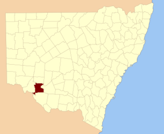
Caira County is one of the 141 Cadastral divisions of New South Wales. It contains the city of Balranald. It is located between where the Murrumbidgee River joins the Murray River to where the Lachlan River joins the Murrumbidgee, containing much of the western Lowbidgee Floodplain. The name "Caira" is believed to derive from a local Aboriginal word.

Murrumbidgee District Cadastral in New South Wales, Australia

The Murrumbidgee District was a district used in New South Wales in the nineteenth century to refer to the land between the Murrumbidgee River and Murray River, that is now mostly known as the Riverina region. Some maps show the district included the parts of what is now the Australian Capital Territory that was to the west of the Murrumbidgee River. The district was originally one of the districts used to refer to the area outside the limits of location, but later continued to be used as the name after counties were proclaimed within this area. It went out of use after 1884, when new districts were proclaimed.

Lowbidgee Floodplain

The Lowbidgee Floodplain extends from Balranald to near Waradgery Station, about 20 km (12 mi) west of Hay, in south-western New South Wales. The Lowbidgee Floodplain is part of the Traditional lands of the Nari Nari and Muthi Muthi Aboriginal peoples.

Bland Creek

The Bland Creek, a mostly–perennial river that is part of the Lachlan sub-catchment of the Murrumbidgee catchment within the Murray–Darling basin, is located in the South West Slopes, and Riverina regions of New South Wales, Australia. The Bland Creek is only connected to the Murray Darling basin when both the Lachlan and Murrumbidgee Rivers are in flood.

Barmedman Creek river in Australia

The Barmedman Creek, a mostly–perennial river that is part of the Lachlan sub-catchment of the Murrumbidgee catchment within the Murray–Darling basin, is located in the South West Slopes, and Riverina regions of New South Wales, Australia. The Barmedman Creek is only connected to the Murray Darling basin when the Bland Creek, the Lachlan and Murrumbidgee Rivers are in flood.

Berthong Creek river in Australia

The Berthong Creek, a mostly–perennial river that is part of the Lachlan sub-catchment of the Murrumbidgee catchment within the Murray–Darling basin, is located in the South West Slopes, and Riverina regions of New South Wales, Australia. The Berthong Creek is only connected to the Murray Darling basin when the Bland Creek, the Lachlan and Murrumbidgee Rivers are in flood.

Balgalal Creek

The Balgalal Creek, a mostly–perennial river that is part of the Lachlan sub-catchment of the Murrumbidgee catchment within the Murray–Darling basin, is located in the South West Slopes region of New South Wales, Australia.

Cooks Vale Creek river in Australia

The Cooks Vale Creek, a mostly–perennial river that is part of the Lachlan sub-catchment of the Murrumbidgee catchment within the Murray–Darling basin, is located in the South West Slopes region of New South Wales, Australia.

Flyers Creek

The Flyers Creek, a mostly–perennial river that is part of the Lachlan sub-catchment of the Murrumbidgee catchment within the Murray–Darling basin, is located in the Central West region of New South Wales, Australia.

Cowriga Creek

The Cowriga Creek, a mostly–perennial river that is part of the Lachlan sub-catchment of the Murrumbidgee catchment within the Murray–Darling basin, is located in the Central West region of New South Wales, Australia.

Bulla Creek river in Australia

The Bulla Creek, a mostly–perennial river that is part of the Lachlan sub-catchment of the Murrumbidgee catchment within the Murray–Darling basin, is located in the South West Slopes region of New South Wales, Australia. The Bulla Creek is only connected to the Murray Darling basin when the Bland Creek and both the Lachlan and Murrumbidgee Rivers are in flood.

Gunningbland Creek river in Australia

The Gunningbland Creek, a perennial river of the Lachlan sub–catchment, part of the Murrumbidgee catchment of the Murray-Darling basin, is located in the Central West region of New South Wales, Australia.

Jerrara Creek river in New South Wales, Australia

The Jerrara Creek, a watercourse that is part of the Lachlan sub-catchment of the Murrumbidgee catchment within the Murray–Darling basin, is located in the South West Slopes region of New South Wales, Australia.

Jerrawa Creek river in Australia

The Jerrawa Creek, a watercourse that is part of the Lachlan sub-catchment of the Murrumbidgee catchment within the Murray–Darling basin, is located in the South West Slopes region of New South Wales, Australia.

Mirrool Creek

The Mirrool Creek, a watercourse that is part of the Lachlan sub-catchment of the Murrumbidgee catchment within the Murray–Darling basin, is located in the Riverina region of New South Wales, Australia. The course of the Mirrool Creek is indefinite at various locations.

References

  1. "Waradgery". Geographical Names Register (GNR) of NSW. Geographical Names Board of New South Wales . Retrieved 11 August 2013. OOjs UI icon edit-ltr-progressive.svg
  2. The New atlas of Australia (John Sands 1886) map 21.