Sturt County

Last updated

Map all coordinates using: OpenStreetMap
Sturt
New South Wales
Sturt NSW.PNG
Location in New South Wales
Lands administrative divisions around Sturt:
Nicholson Nicholson Cooper
Waradgery Sturt Cooper
Waradgery Boyd Boyd
The Carathool Bridge over the Murrumbidgee between Sturt and Boyd CarrathoolBridge.JPG
The Carathool Bridge over the Murrumbidgee between Sturt and Boyd
Sturt County NSW as shown on John Sands 1886 map) Sturt Count NSW (John Sands 1886 map).png
Sturt County NSW as shown on John Sands 1886 map)

Sturt County is one of the 141 Cadastral divisions of New South Wales. It contains the locality of Carrathool. The Murrumbidgee River is the southern boundary.

Sturt County was named in honour of the explorer, soldier and public servant Charles Sturt (1795-1869). [2]

Parishes within this county

A full list of parishes found within this county; their current LGA and mapping coordinates to the approximate centre of each location is as follows:

ParishLGACoordinates
Alleyne Carrathool Shire Council 34°18′54″S145°28′04″E / 34.31500°S 145.46778°E / -34.31500; 145.46778 (Alleyne)
Baillie City of Griffith 34°22′54″S145°55′04″E / 34.38167°S 145.91778°E / -34.38167; 145.91778 (Baillie)
Ballingall City of Griffith 34°13′54″S146°00′04″E / 34.23167°S 146.00111°E / -34.23167; 146.00111 (Ballingall)
Beabula Hay Shire Council 34°13′54″S145°11′04″E / 34.23167°S 145.18444°E / -34.23167; 145.18444 (Beabula)
Bendigo City of Griffith 34°21′54″S145°47′04″E / 34.36500°S 145.78444°E / -34.36500; 145.78444 (Bendigo)
Benerembah Carrathool Shire Council 34°28′54″S145°55′04″E / 34.48167°S 145.91778°E / -34.48167; 145.91778 (Benerembah)
Bringagee Carrathool Shire Council 34°25′54″S145°45′04″E / 34.43167°S 145.75111°E / -34.43167; 145.75111 (Bringagee)
Buckley Carrathool Shire Council 34°09′54″S145°29′04″E / 34.16500°S 145.48444°E / -34.16500; 145.48444 (Buckley)
Cajaldura Carrathool Shire Council 34°23′54″S145°34′04″E / 34.39833°S 145.56778°E / -34.39833; 145.56778 (Cajaldura)
Carrathool Carrathool Shire Council 34°22′54″S145°30′04″E / 34.38167°S 145.50111°E / -34.38167; 145.50111 (Carrathool)
Carrego Carrathool Shire Council 34°05′54″S145°28′04″E / 34.09833°S 145.46778°E / -34.09833; 145.46778 (Carrego)
Cockburn Carrathool Shire Council 34°08′54″S145°44′04″E / 34.14833°S 145.73444°E / -34.14833; 145.73444 (Cockburn)
Denny Carrathool Shire Council 34°02′54″S145°51′04″E / 34.04833°S 145.85111°E / -34.04833; 145.85111 (Denny)
Djallah City of Griffith 34°23′54″S145°51′04″E / 34.39833°S 145.85111°E / -34.39833; 145.85111 (Djallah)
Downey Hay Shire Council 34°11′54″S145°09′04″E / 34.19833°S 145.15111°E / -34.19833; 145.15111 (Downey)
Ercildoune Carrathool Shire Council 34°18′54″S145°35′04″E / 34.31500°S 145.58444°E / -34.31500; 145.58444 (Ercildoune)
Hervey Carrathool Shire Council 34°10′54″S145°42′04″E / 34.18167°S 145.70111°E / -34.18167; 145.70111 (Hervey)
Houlong Carrathool Shire Council 34°21′54″S145°23′04″E / 34.36500°S 145.38444°E / -34.36500; 145.38444 (Houlong)
Hyde Park Carrathool Shire Council 34°18′54″S145°41′04″E / 34.31500°S 145.68444°E / -34.31500; 145.68444 (Hyde Park)
Kooba Carrathool Shire Council 34°04′54″S146°00′04″E / 34.08167°S 146.00111°E / -34.08167; 146.00111 (Kooba)
Kooroongal Carrathool Shire Council 34°23′54″S145°40′04″E / 34.39833°S 145.66778°E / -34.39833; 145.66778 (Kooroongal)
Learmonth City of Griffith 34°15′54″S145°48′04″E / 34.26500°S 145.80111°E / -34.26500; 145.80111 (Learmonth)
Lethington Carrathool Shire Council 34°11′54″S145°26′04″E / 34.19833°S 145.43444°E / -34.19833; 145.43444 (Lethington)
Livingstone Carrathool Shire Council 34°05′54″S145°37′04″E / 34.09833°S 145.61778°E / -34.09833; 145.61778 (Livingstone)
Maiden Carrathool Shire Council 34°02′54″S145°43′04″E / 34.04833°S 145.71778°E / -34.04833; 145.71778 (Maiden)
Mair Carrathool Shire Council 34°10′54″S145°37′04″E / 34.18167°S 145.61778°E / -34.18167; 145.61778 (Mair)
Mills Carrathool Shire Council 34°07′54″S145°19′04″E / 34.13167°S 145.31778°E / -34.13167; 145.31778 (Mills)
Mirrool City of Griffith 34°08′54″S146°02′04″E / 34.14833°S 146.03444°E / -34.14833; 146.03444 (Mirrool)
Munro Carrathool Shire Council 34°02′54″S145°55′04″E / 34.04833°S 145.91778°E / -34.04833; 145.91778 (Munro)
North Bringagee City of Griffith 34°09′54″S145°49′04″E / 34.16500°S 145.81778°E / -34.16500; 145.81778 (North Bringagee)
North Uardry Carrathool Shire Council 34°12′54″S145°19′04″E / 34.21500°S 145.31778°E / -34.21500; 145.31778 (North Uardry)
O'Brien City of Griffith 33°59′54″S145°53′04″E / 33.99833°S 145.88444°E / -33.99833; 145.88444 (O'Brien)
Quambatook Carrathool Shire Council 34°14′54″S145°36′04″E / 34.24833°S 145.60111°E / -34.24833; 145.60111 (Quambatook)
Tabbita Carrathool Shire Council 33°54′54″S146°02′04″E / 33.91500°S 146.03444°E / -33.91500; 146.03444 (Tabbita)
Tabbita Carrathool Shire Council 33°56′54″S145°57′04″E / 33.94833°S 145.95111°E / -33.94833; 145.95111 (Tabbita)
Terrapee Carrathool Shire Council 34°13′54″S145°31′04″E / 34.23167°S 145.51778°E / -34.23167; 145.51778 (Terrapee)
Toms Point Carrathool Shire Council 34°29′54″S145°14′04″E / 34.49833°S 145.23444°E / -34.49833; 145.23444 (Toms Point)
Uardry Carrathool Shire Council 34°20′54″S145°18′04″E / 34.34833°S 145.30111°E / -34.34833; 145.30111 (Uardry)
Warburn City of Griffith 34°16′54″S145°53′04″E / 34.28167°S 145.88444°E / -34.28167; 145.88444 (Warburn)
Wiveon Carrathool Shire Council 34°14′54″S145°42′04″E / 34.24833°S 145.70111°E / -34.24833; 145.70111 (Wiveon)
Wowong Carrathool Shire Council 34°28′54″S145°50′04″E / 34.48167°S 145.83444°E / -34.48167; 145.83444 (Wowong)
Wycheproof Carrathool Shire Council 34°04′54″S145°32′04″E / 34.08167°S 145.53444°E / -34.08167; 145.53444 (Wycheproof)
Yannaway Carrathool Shire Council 34°13′54″S145°25′04″E / 34.23167°S 145.41778°E / -34.23167; 145.41778 (Yannaway)

Related Research Articles

<span class="mw-page-title-main">Charles Sturt</span> Australian explorer (1795-1869)

Charles Napier Sturt was a British officer and explorer of Australia, and part of the European exploration of Australia. He led several expeditions into the interior of the continent, starting from Sydney and later from Adelaide. His expeditions traced several of the westward-flowing rivers, establishing that they all merged into the Murray River, which flows into the Southern Ocean. He was searching to prove his own passionately held belief that an "inland sea" was located at the centre of the continent. He reached the rank of Captain, served in several appointed posts, and on the Legislative Council.

Willyama was an electoral district for the Legislative Assembly in the Australian State of New South Wales named after the original aboriginal name for the Broken Hill area. It included southern Broken Hill and sparsely occupied areas further south. Since 1904 all of the town was in the district of Broken Hill, surrounded by the rural district of Sturt. In the 1912 redistribution north Broken Hill was in Sturt, while Willyama was created to include South Broken Hill, the southern part of Sturt and the north western part of Murray. In 1920, it was combined with Sturt, Cobar and much of the area of Murray to create a three-member Sturt. Willyama's only member was Jabez Wright representing Labor.

Cobar was an electoral district of the Legislative Assembly in the Australian state of New South Wales which was named after the town of Cobar. It was first created in 1894 and abolished in 1920. Cobar was recreated in 1930 and abolished in 1968.

<span class="mw-page-title-main">Evelyn County, New South Wales</span> Cadastral in New South Wales, Australia

Evelyn County is one of the 141 Cadastral divisions of New South Wales, Australia.

<span class="mw-page-title-main">Poole County</span> Cadastral in New South Wales, Australia

Poole County is one of the 141 Cadastral divisions of New South Wales. It is located in the extreme north-west of the state, abutting Cameron Corner. It includes parts of Sturt National Park.

<span class="mw-page-title-main">Charles Sturt University, New South Wales</span> Suburb of Wagga Wagga, New South Wales, Australia

Charles Sturt University is a suburb and location for Charles Sturt University's Wagga Wagga Campus is located in the suburb of Estella.

<span class="mw-page-title-main">Rufus River</span> River in New South Wales, Australia

Rufus River, a watercourse of the Murray catchment and part of the Murray–Darling basin, is located in south western New South Wales, Australia.

The Barrier Ranges or sometimes the Barrier Range and historically the Stanley's Barrier Range, is a mountain range that comprises a series of hills and higher grounds in the far western region of New South Wales, Australia, surrounding the city of Broken Hill.

<span class="mw-page-title-main">Parish of Mount King</span>

Mount King, New South Wales is a civil parish of Poole County in far North West New South Wales, located at.

<span class="mw-page-title-main">Parish of Fort Grey</span>

Fort Grey is a remote civil parish of Poole County in far North West New South Wales. located at 29.1731°S 141.0307°E.

<span class="mw-page-title-main">Parish of Pinaroo</span>

Pinaroo is a remote civil parish of Poole County in far north west New South Wales, located at 29°08′04″S 141°06′55″E.

<span class="mw-page-title-main">Parish of Sturt</span>

Sturt Parish is a remote civil parish of Poole County in far North West New South Wales, located at 29.433056°S 141.519722°E.

Utah Parish, New South Wales is a remote rural locality and civil parish of Evelyn County in far northwest New South Wales. located at 30°04′48″S 142°03′23″E.

Koorningbirry located at 30°23′56″S 142°11′53″E is a remote rural locality and civil parish of Mootwingee County in far North West New South Wales.

The Parish of Blackwood is a remote civil parish of Poole County in far North West New South Wales,

The Parish of Tindara is a remote civil parish of Poole County in far North West New South Wales,.

<span class="mw-page-title-main">Parish of Yarraba</span>

The Parish of Yarraba is a remote civil parish of Poole County in far North West New South Wales,.

<span class="mw-page-title-main">Parish of Hervey (Sturt County)</span>

Hervey Parish, New South Wales is both a rural locality of Carrathool Shire Council located at 34°10′54″S 145°42′04″E and a civil Parish of Sturt County, New South Wales.

<span class="mw-page-title-main">Mirrool Parish (Sturt County), New South Wales</span> Place in New South Wales, Australia

Mirrool Parish is a civil parish of Sturt County, New South Wales.

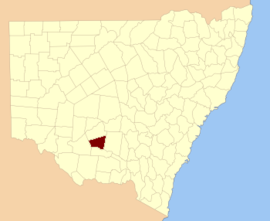
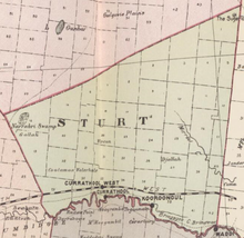
Sturt, an electoral district of the Legislative Assembly in the Australian state of New South Wales, had two incarnations, from 1889 until 1968 and from 1971 until 1981.

References

  1. The New atlas of Australia (John Sands 1886) map 21.
  2. "Sturt County". Geographical Names Register (GNR) of NSW. Geographical Names Board of New South Wales. OOjs UI icon edit-ltr-progressive.svg