Mirrool Parish (Sturt County), New South Wales

Last updated

Mirrool Parish
New South Wales
Sturt Count NSW (John Sands 1886 map).png
Sturt County NSW as shown on John Sands 1886 map) [1]
Australia New South Wales location map blank.svg
Red pog.svg
Mirrool Parish
Coordinates 34°17′24″S146°2′24″E / 34.29000°S 146.04000°E / -34.29000; 146.04000 Coordinates: 34°17′24″S146°2′24″E / 34.29000°S 146.04000°E / -34.29000; 146.04000
Population25,000-30,000 In Griffith City (2015) [2]
Postcode(s) 2680
Elevation129.2 m (424 ft)
Time zone AEST (UTC+10)
 • Summer (DST) AEDT (UTC+11)
Location
LGA(s) City of Griffith
County Sturt
State electorate(s) Murray
Federal Division(s) Farrer
Mean max tempMean min tempAnnual rainfall
23.8 °C
75 °F
10.0 °C
50 °F
397.3 mm
15.6 in

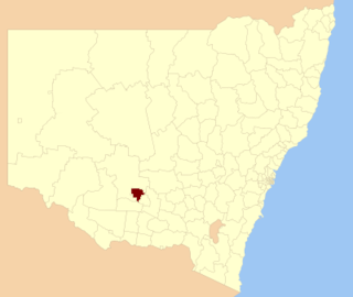
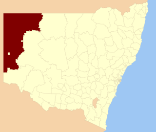
Mirrool Parish is a civil parish of Sturt County, New South Wales. [3]

Civil parish Territorial designation and lowest tier of local government in England

In England, a civil parish is a type of administrative parish used for local government, they are a territorial designation which is the lowest tier of local government below districts and counties, or their combined form, the unitary authority. Civil parishes can trace their origin to the ancient system of ecclesiastical parishes which historically played a role in both civil and ecclesiastical administration; civil and religious parishes were formally split into two types in the 19th century and are now entirely separate. The unit was devised and rolled out across England in the 1860s.

Sturt County Cadastral in New South Wales, Australia

Sturt County is one of the 141 Cadastral divisions of New South Wales. It contains the locality of Carrathool. The Murrumbidgee River is the southern boundary.

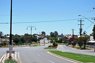
The Parish is located at 34°08′54″S and 146°02′04″E just north of the town of Griffith, New South Wales in the Riverina Region.

North one of the four cardinal directions

North is one of the four compass points or cardinal directions. It is the opposite of south and is perpendicular to east and west. North is a noun, adjective, or adverb indicating direction or geography.

Griffith, New South Wales City in New South Wales, Australia

Griffith is a major regional city in the Murrumbidgee Irrigation Area that is located in the north-western part of the Riverina region of New South Wales, known commonly as the food bowl of Australia. It is also the seat of the City of Griffith local government area. Like the Australian capital, Canberra, and the nearby town of Leeton, Griffith was designed by Walter Burley Griffin and Marion Mahony Griffin. Griffith was named after Arthur Hill Griffith, the first New South Wales Minister of Public Works. Griffith was proclaimed a city in 1987, and had a population of 19,144 in 2016.

Riverina Region in New South Wales, Australia

The Riverina is an agricultural region of South-Western New South Wales (NSW), Australia. The Riverina is distinguished from other Australian regions by the combination of flat plains, warm to hot climate and an ample supply of water for irrigation. This combination has allowed the Riverina to develop into one of the most productive and agriculturally diverse areas of Australia. Bordered on the south by the state of Victoria and on the east by the Great Dividing Range, the Riverina covers those areas of New South Wales in the Murray and Murrumbidgee drainage zones to their confluence in the west.

The township of Mirrool, New South Wales is 80km to the east.

East one of the four cardinal directions

East is one of the four cardinal directions or points of the compass. It is the opposite direction from west.

See also

Mirrool Creek

The Mirrool Creek, a watercourse that is part of the Lachlan sub-catchment of the Murrumbidgee catchment within the Murray–Darling basin, is located in the Riverina region of New South Wales, Australia. The course of the Mirrool Creek is indefinite at various locations.

Related Research Articles

Greater Hume Shire Local government area in New South Wales, Australia

Greater Hume Shire is a local government area in the Riverina region of southern New South Wales, Australia. The Shire was formed in 2004 incorporating Culcairn Shire, the majority of Holbrook Shire and part of Hume Shire. The shire had an estimated population of 10,137 as at 2012.

South Windsor, New South Wales Suburb of City of Hawkesbury, New South Wales, Australia

South Windsor is a suburb of the town of Windsor, on the outskirts of Sydney, in the state of New South Wales, Australia. It is generally bounded in the west by Rickabys Creek and in the east by South Creek, both tributaries of the Hawkesbury River. It is also home of Bede Polding College, a Catholic secondary school.

Uriarra, New South Wales Suburb of Yass Valley Council, New South Wales, Australia

Uriarra is a locality in the Southern Tablelands of New South Wales, Australia in the Yass Valley Shire. It is north of the locality of Uriarra in the Australian Capital Territory and north-east of Canberra. At the 2016 census, it had a population of 30. The locality is mostly located in the Urayarra parish of Cowley County, although part of it in Pabral parish, which lies further west.

Bannaby, New South Wales Town in New South Wales, Australia

Bannaby is a locality in the Southern Tablelands of New South Wales, Australia in Upper Lachlan Shire. It is located near the township of Taralga, on the Bannaby road. At the 2016 census, it had a population of 36.

Coolamon, New South Wales Town in New South Wales, Australia

Coolamon is a town in the Riverina region of south-west New South Wales, Australia. Coolamon is 40 kilometres (25 mi) north-west of Wagga Wagga and 506 kilometres (314 mi) south-west of Sydney via the Hume and Sturt Highways. The town is situated on the railway line between Junee and Narrandera. Coolamon had a population of 2,199 at the 2016 census and is 290 metres (950 ft) above sea level. It is the administrative and service centre for the local government area which bears its name—Coolamon Shire.

Wakool Shire Local government area in New South Wales, Australia

Wakool Shire was a local government area in the Riverina region of New South Wales, Australia. The Shire was located between the Murray River and the Murrumbidgee River and adjacent to the Sturt Highway. Towns in the Shire are Barham, Moulamein, Tooleybuc, Wakool and Koraleigh.

City of Griffith Local government area in New South Wales, Australia

The City of Griffith is a local government area in Riverina region of south-western New South Wales, Australia. The area comprises 1,640 square kilometres (630 sq mi) and is located in the Murrumbidgee Irrigation Area and on Kidman Way.

Temora Shire Local government area in New South Wales, Australia

Temora Shire is a local government area in the Riverina region of New South Wales, Australia. It is on Burley Griffin Way. The Shire was created on 1 January 1981 via the amalgamation of Narraburra Shire and the Municipality of Temora.

Narrandera Shire Local government area in New South Wales, Australia

Narrandera Shire is a local government area in the Riverina region of south-western New South Wales, Australia. The Shire is located adjacent to the Sturt and Newell Highways.

Hay Shire Local government area in New South Wales, Australia

The Hay Shire is a local government area in the Riverina area of south-western New South Wales, Australia. The Shire comprises 11,326 square kilometres (4,373 sq mi) and is located adjacent to the Sturt, Mid-western and Cobb Highways. The area includes the towns of Hay, Booligal and Maude.

Balranald Shire Local government area in New South Wales, Australia

Balranald Shire is a local government area in the Riverina area of western New South Wales, Australia on the Sturt Highway. It is the location of World Heritage listed Mungo National Park. It includes the towns of Balranald and Euston. Other localities in the Shire include Kyalite, Hatfield, Penarie, Clare and Oxley.

Beelbangera Town in New South Wales, Australia

Beelbangera is a town in the north west of the Riverina and situated about 2 kilometres north-east of Griffith and about 7 kilometres south-west of Yenda. At the 2011 census Beelbangera had a population of 311.

Unincorporated Far West Region Local government area in New South Wales, Australia

The Unincorporated Far West Region is an unincorporated area in the Far West region of New South Wales, Australia. The area is one of only two areas in New South Wales that are not part of any local government area. The region includes several small towns including Tibooburra, Milparinka and Silverton. Silverton and Tibooburra have village councils. The region surrounds Broken Hill, but does not include it, which is in the separate City of Broken Hill local government area.

Charles Sturt University, New South Wales Suburb of Wagga Wagga, New South Wales, Australia

Charles Sturt University is a suburb and location for Charles Sturt University's Wagga Wagga Campus is located approximately 2.5 kilometres from Estella.

Wallaroo, New South Wales Town in New South Wales, Australia

Wallaroo is a rural locality in New South Wales close to the Australian Capital Territory. It lies north of the Australian Capital Territory border, north west of Hall, west of the Barton Highway, and east of the Murrumbidgee River. It is approximately 19 kilometres north-west of the Australian city of Canberra. At the 2016 census, it had a population of 707.

Cootamundra-Gundagai Regional Council Local government area in New South Wales, Australia

Cootamundra-Gundagai Regional Council is a local government area located in the South West Slopes and Riverina regions of New South Wales, Australia. The council was formed on 12 May 2016 through a merger of the Cootamundra and Gundagai shires. Originally named Gundagai Council, the name was changed Cootamundra-Gundagai Regional Council on 7 September 2016.

Nanima Town in New South Wales, Australia

Nanima is a locality in the Yass Valley Council area, New South Wales, Australia. It lies on the both sides of the Murrumbateman Road between Murrumbateman and Gundaroo, about 37 km north of Canberra. At the 2016 census, it had a population of 165.

References

  1. The New atlas of Australia (John Sands 1886) map 21.
  2. "3218.0 – Regional Population Growth, Australia, 2014-15: Population Estimates by Significant Urban Area, 2005 to 2015". Australian Bureau of Statistics. Australian Bureau of Statistics. 30 March 2016. Retrieved 12 September 2016. Estimated resident population, 30 June 2015.
  3. "Sturt County". Geographical Names Register (GNR) of NSW. Geographical Names Board of New South Wales. OOjs UI icon edit-ltr-progressive.svg