Clyde County

Last updated

Map all coordinates using: OpenStreetMap  
Download coordinates as: KML  ·  GPX
Clyde
New South Wales
Clyde NSW.PNG
Location in New South Wales
Lands administrative divisions around Clyde:
Gunderbooka Narran Finch
Cowper Clyde Leichhardt
Cowper Canbelego Gregory

Clyde County is one of the 141 Cadastral divisions of the Australian state of New South Wales. It is located between the Bogan River and Barwon River in the area between them where they join. This is the area to the south of Brewarrina, as far east as the Carinda area. A very small part of the Macquarie River and Castlereagh River is also part of the boundary in the north-east.

New South Wales State of Australia

New South Wales is a state on the east coast of Australia. It borders Queensland to the north, Victoria to the south, and South Australia to the west. Its coast borders the Tasman Sea to the east. The Australian Capital Territory is an enclave within the state. New South Wales' state capital is Sydney, which is also Australia's most populous city. In September 2018, the population of New South Wales was over 8 million, making it Australia's most populous state. Just under two-thirds of the state's population, 5.1 million, live in the Greater Sydney area. Inhabitants of New South Wales are referred to as New South Welshmen.

Bogan River river

Bogan River, a perennial river that is part of the Macquarie–Barwon catchment within the Murray–Darling basin, is located in the central west and Orana regions of New South Wales, Australia.

Barwon River (New South Wales) river located in the Orana region of New South Wales, Australia

Barwon River, a perennial river that is part of the Murray–Darling basin, is located in the north-west slopes and Orana regions of New South Wales, Australia.

Clyde County was named in honour of Field Marshal Sir Colin Campbell, Baron Clyde (1792–1863). [1]

Colin Campbell, 1st Baron Clyde British Army officer

Field Marshal Colin Campbell, 1st Baron Clyde,, was a British Army officer. After serving in the Peninsular War and the War of 1812, he commanded the 98th Regiment of Foot during the First Opium War and then commanded a brigade during the Second Anglo-Sikh War. He went on to command the Highland Brigade at the Battle of Alma and with his "thin red line of Highlanders" he repulsed the Russian attack on Balaclava during the Crimean War. At an early stage of the Indian Mutiny, he became Commander-in-Chief, India and, in that role, he relieved and then evacuated Lucknow and, after attacking and decisively defeating Tatya Tope at the Second Battle of Cawnpore, captured Lucknow again. Whilst still commander-in-chief he dealt with the 'White Mutiny' among East India Company troops, and organised the army sent east in the Second Opium War.

Parishes within this county

A full list of parishes found within this county, their current local government area, and mapping coordinates to the approximate centre of each location is as follows:

Local government in Australia is the third tier of government in Australia administered by the states and territories, which in turn are beneath the federal tier. Local government is not mentioned in the Constitution of Australia and two referenda in the 1970s and 1980s to alter the Constitution relating to local government were unsuccessful. Every state government recognises local government in their respective constitutions. Unlike Canada or the United States, there is only one level of local government in each state, with no distinction such as cities and counties.

ParishLGACoordinates
Annan Brewarrina Shire 30°30′26″S147°02′46″E / 30.50722°S 147.04611°E / -30.50722; 147.04611 (Annan)
Back Willoi Walgett Shire 30°13′54″S147°24′04″E / 30.23167°S 147.40111°E / -30.23167; 147.40111 (Back Willoi)
Ballaree Warren Shire 30°29′54″S147°18′04″E / 30.49833°S 147.30111°E / -30.49833; 147.30111 (Ballaree)
Beemery Bourke Shire 29°56′31″S146°26′28″E / 29.94194°S 146.44111°E / -29.94194; 146.44111 (Beemery)
Bendermere Brewarrina Shire 30°08′41″S146°54′38″E / 30.14472°S 146.91056°E / -30.14472; 146.91056 (Bendermere)
Billybingbone Brewarrina Shire 30°25′38″S147°02′37″E / 30.42722°S 147.04361°E / -30.42722; 147.04361 (Billybingbone)
Blowan Walgett Shire 30°17′54″S147°30′04″E / 30.29833°S 147.50111°E / -30.29833; 147.50111 (Blowan)
Bouka Bouka Warren Shire 30°25′54″S147°12′04″E / 30.43167°S 147.20111°E / -30.43167; 147.20111 (Bouka Bouka)
Brewarrina Brewarrina Shire 29°58′26″S146°50′10″E / 29.97389°S 146.83611°E / -29.97389; 146.83611 (Brewarrina)
Briarie Brewarrina Shire 30°07′33″S147°08′49″E / 30.12583°S 147.14694°E / -30.12583; 147.14694 (Briarie)
Buckinguy Walgett Shire 30°11′54″S147°28′04″E / 30.19833°S 147.46778°E / -30.19833; 147.46778 (Buckinguy)
Carinda Walgett Shire 30°27′54″S147°46′04″E / 30.46500°S 147.76778°E / -30.46500; 147.76778 (Carinda)
Cashmere Warren Shire 30°25′54″S147°18′04″E / 30.43167°S 147.30111°E / -30.43167; 147.30111 (Cashmere)
Charlton Brewarrina Shire 30°12′00″S146°47′43″E / 30.20000°S 146.79528°E / -30.20000; 146.79528 (Charlton)
Clements Warren Shire 30°47′54″S147°18′04″E / 30.79833°S 147.30111°E / -30.79833; 147.30111 (Clements)
Coolaree Brewarrina Shire 30°04′16″S146°39′56″E / 30.07111°S 146.66556°E / -30.07111; 146.66556 (Coolaree)
Coorabur Walgett Shire 30°19′54″S147°42′04″E / 30.33167°S 147.70111°E / -30.33167; 147.70111 (Coorabur)
Cowabee Brewarrina Shire 30°08′02″S146°59′47″E / 30.13389°S 146.99639°E / -30.13389; 146.99639 (Cowabee)
Cowal Warren Shire 30°50′40″S147°11′23″E / 30.84444°S 147.18972°E / -30.84444; 147.18972 (Cowal)
Cowga Brewarrina Shire 30°29′05″S146°57′07″E / 30.48472°S 146.95194°E / -30.48472; 146.95194 (Cowga)
Cox Warren Shire 30°33′46″S147°26′37″E / 30.56278°S 147.44361°E / -30.56278; 147.44361 (Cox)
Cuddie Walgett Shire 30°19′49″S147°21′46″E / 30.33028°S 147.36278°E / -30.33028; 147.36278 (Cuddie)
Derri Derri Warren Shire 30°39′31″S147°22′19″E / 30.65861°S 147.37194°E / -30.65861; 147.37194 (Derri Derri)
Dooral Brewarrina Shire 30°03′41″S147°01′43″E / 30.06139°S 147.02861°E / -30.06139; 147.02861 (Dooral)
Druid Brewarrina Shire 29°58′58″S146°39′12″E / 29.98278°S 146.65333°E / -29.98278; 146.65333 (Druid)
Esperance Warren Shire 30°35′22″S147°27′46″E / 30.58944°S 147.46278°E / -30.58944; 147.46278 (Esperance)
Ethelberg Brewarrina Shire 30°13′25″S147°08′35″E / 30.22361°S 147.14306°E / -30.22361; 147.14306 (Ethelberg)
Galar Brewarrina Shire 30°12′51″S147°01′31″E / 30.21417°S 147.02528°E / -30.21417; 147.02528 (Galar)
Gangarry Warren Shire 30°27′54″S147°28′04″E / 30.46500°S 147.46778°E / -30.46500; 147.46778 (Gangarry)
Geera Walgett Shire 30°09′54″S147°24′04″E / 30.16500°S 147.40111°E / -30.16500; 147.40111 (Geera)
Gidgerah Warren Shire 30°31′52″S147°32′55″E / 30.53111°S 147.54861°E / -30.53111; 147.54861 (Gidgerah)
Ginge Walgett Shire 30°21′54″S147°14′04″E / 30.36500°S 147.23444°E / -30.36500; 147.23444 (Ginge)
Ginghet Warren Shire 30°25′54″S147°24′04″E / 30.43167°S 147.40111°E / -30.43167; 147.40111 (Ginghet)
Gobollion Warren Shire 30°39′23″S147°16′11″E / 30.65639°S 147.26972°E / -30.65639; 147.26972 (Gobollion)
Gongolgon Brewarrina Shire 30°23′48″S146°55′23″E / 30.39667°S 146.92306°E / -30.39667; 146.92306 (Gongolgon)
Gralwin Warren Shire 30°44′10″S147°22′55″E / 30.73611°S 147.38194°E / -30.73611; 147.38194 (Gralwin)
Grandool Walgett Shire 30°13′26″S147°34′36″E / 30.22389°S 147.57667°E / -30.22389; 147.57667 (Grandool)
Grandoonbone Brewarrina Shire 30°36′06″S146°58′32″E / 30.60167°S 146.97556°E / -30.60167; 146.97556 (Grandoonbone)
Gunderwerrie Brewarrina Shire 29°58′21″S146°44′24″E / 29.97250°S 146.74000°E / -29.97250; 146.74000 (Gunderwerrie)
Haradon Brewarrina Shire 30°06′41″S146°35′57″E / 30.11139°S 146.59917°E / -30.11139; 146.59917 (Haradon)
Higgins Walgett Shire 30°37′54″S147°14′04″E / 30.63167°S 147.23444°E / -30.63167; 147.23444 (Higgins)
Langmore Brewarrina Shire 30°16′18″S146°56′54″E / 30.27167°S 146.94833°E / -30.27167; 146.94833 (Langmore)
Lindsay Brewarrina Shire 30°14′22″S147°00′09″E / 30.23944°S 147.00250°E / -30.23944; 147.00250 (Lindsay)
Lynch Brewarrina Shire 30°10′17″S146°40′41″E / 30.17139°S 146.67806°E / -30.17139; 146.67806 (Lynch)
Meranda Warren Shire 30°41′54″S147°28′04″E / 30.69833°S 147.46778°E / -30.69833; 147.46778 (Meranda)
Merunda Warren Shire 30°43′01″S147°26′54″E / 30.71694°S 147.44833°E / -30.71694; 147.44833 (Merunda)
Molle Coonamble Shire 30°35′02″S147°37′04″E / 30.58389°S 147.61778°E / -30.58389; 147.61778 (Molle)
Morla Brewarrina Shire 30°13′46″S146°44′05″E / 30.22944°S 146.73472°E / -30.22944; 146.73472 (Morla)
Mundadoo Brewarrina Shire 30°47′51″S147°12′18″E / 30.79750°S 147.20500°E / -30.79750; 147.20500 (Mundadoo)
Mundawah Warren Shire 30°33′54″S147°08′04″E / 30.56500°S 147.13444°E / -30.56500; 147.13444 (Mundawah)
Navina Brewarrina Shire 30°04′57″S146°53′00″E / 30.08250°S 146.88333°E / -30.08250; 146.88333 (Navina)
Quabothoo Coonamble Shire 30°33′54″S147°44′04″E / 30.56500°S 147.73444°E / -30.56500; 147.73444 (Quabothoo)
Ridge Warren Shire 30°51′54″S147°16′04″E / 30.86500°S 147.26778°E / -30.86500; 147.26778 (Ridge)
Stonehenge Brewarrina Shire 30°02′44″S146°28′14″E / 30.04556°S 146.47056°E / -30.04556; 146.47056 (Stonehenge)
Thuara Warren Shire 30°27′54″S147°14′04″E / 30.46500°S 147.23444°E / -30.46500; 147.23444 (Thuara)
Thudie Brewarrina Shire 30°21′21″S147°03′55″E / 30.35583°S 147.06528°E / -30.35583; 147.06528 (Thudie)
Tichawanta Brewarrina Shire 30°05′37″S146°46′27″E / 30.09361°S 146.77417°E / -30.09361; 146.77417 (Tichawanta)
Tulloch Brewarrina Shire 30°15′22″S146°48′47″E / 30.25611°S 146.81306°E / -30.25611; 146.81306 (Tulloch)
Uki Bogan Shire 30°50′35″S147°06′14″E / 30.84306°S 147.10389°E / -30.84306; 147.10389 (Uki)
Ulourie Walgett Shire 30°19′31″S147°14′52″E / 30.32528°S 147.24778°E / -30.32528; 147.24778 (Ulourie)
Wammerawa Walgett Shire 30°21′24″S147°35′24″E / 30.35667°S 147.59000°E / -30.35667; 147.59000 (Wammerawa)
Waveney Brewarrina Shire 30°32′57″S147°02′31″E / 30.54917°S 147.04194°E / -30.54917; 147.04194 (Waveney)
Weeli Brewarrina Shire 30°39′23″S147°10′00″E / 30.65639°S 147.16667°E / -30.65639; 147.16667 (Weeli)
Welman Brewarrina Shire 30°00′40″S146°55′30″E / 30.01111°S 146.92500°E / -30.01111; 146.92500 (Welman)
Weribiddee Walgett Shire 30°25′07″S147°43′06″E / 30.41861°S 147.71833°E / -30.41861; 147.71833 (Weribiddee)
Wilga Brewarrina Shire 30°24′47″S147°07′53″E / 30.41306°S 147.13139°E / -30.41306; 147.13139 (Wilga)
Willa Murra Brewarrina Shire unknown
Willary Brewarrina Shire 30°29′05″S147°08′27″E / 30.48472°S 147.14083°E / -30.48472; 147.14083 (Willary)
Willenbone Walgett Shire 30°24′18″S147°35′50″E / 30.40500°S 147.59722°E / -30.40500; 147.59722 (Willenbone)
Willewa Walgett Shire 30°27′54″S147°38′04″E / 30.46500°S 147.63444°E / -30.46500; 147.63444 (Willewa)
Willi Culling Warren Shire 30°42′17″S147°16′23″E / 30.70472°S 147.27306°E / -30.70472; 147.27306 (Willi Culling)
Willoi Walgett Shire 30°11′54″S147°18′04″E / 30.19833°S 147.30111°E / -30.19833; 147.30111 (Willoi)
Womboin Warren Shire 30°35′01″S147°20′59″E / 30.58361°S 147.34972°E / -30.58361; 147.34972 (Womboin)
Wommera Brewarrina Shire 30°02′00″S146°48′03″E / 30.03333°S 146.80083°E / -30.03333; 146.80083 (Wommera)
Wommo Walgett Shire 30°21′59″S147°18′56″E / 30.36639°S 147.31556°E / -30.36639; 147.31556 (Wommo)
Wyabray Walgett Shire 30°09′54″S147°18′04″E / 30.16500°S 147.30111°E / -30.16500; 147.30111 (Wyabray)
Yambacuna Brewarrina Shire 29°58′34″S146°34′15″E / 29.97611°S 146.57083°E / -29.97611; 146.57083 (Yambacuna)
Yanda Walgett Shire 30°24′39″S147°27′22″E / 30.41083°S 147.45611°E / -30.41083; 147.45611 (Yanda)
Yarea Warren Shire 30°39′54″S147°32′04″E / 30.66500°S 147.53444°E / -30.66500; 147.53444 (Yarea)
Yarrawin Brewarrina Shire 30°17′34″S147°10′14″E / 30.29278°S 147.17056°E / -30.29278; 147.17056 (Yarrawin)

Related Research Articles

Clyde River National Park Protected area in New South Wales, Australia

Clyde River is a national park in south-eastern New South Wales (Australia) between Batemans Bay and Nelligen. It includes 9 km of river frontage to the Clyde River, bounded on three sides by the Clyde River and on the northeast by the Kings Highway. It was created from a part of Benandarah State Forest; in 2000 10.91 km2 of the state forest was set aside as a national park. The park forms part of the Ulladulla to Merimbula Important Bird Area, identified as such by BirdLife International because of its importance for swift parrots.

The south-east coast drainage division is the very long, narrow area of southern Australia between the Great Dividing Range and the Coral and Tasman seas, and the Bass Strait. It includes the small part of south-eastern South Australia which lies to the east of the Murray-Darling Basin, and all of coastal Victoria and coastal New South Wales. While the southern, eastern, and western boundaries are clearly defined by geography, the northern boundary is arbitrarily defined as the New South Wales - Queensland border. The distinguishing feature of the drainage basin is the Great Dividing Range and the associated Australian Alps.

Clyde River (New South Wales) river

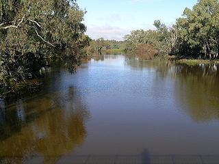
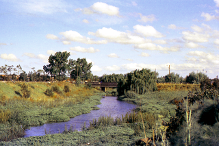
The Clyde River is an open intermediate tide dominated drowned valley estuary; or perennial river that flows into the Tasman Sea, located in the South Coast region of New South Wales, Australia.

Budawang Range

The Budawang Range, commonly called The Budawangs, a rugged mountain range within the Budawang National Park and the Morton National Park, are part of a spur off the Great Dividing Range and are located in the South Coast region of New South Wales, Australia.

Lands administrative divisions of New South Wales Wikimedia list article

The lands administrative divisions of New South Wales refers to the 141 counties within the Colony of New South Wales, that later became the Australian state of New South Wales.

Cook County, New South Wales Cadastral in New South Wales, Australia

Cook County was one of the original Nineteen Counties in New South Wales and is now one of the 141 Cadastral divisions of New South Wales. It includes the area to the west of Sydney in the Blue Mountains, between the Colo River in the north, and the Coxs River in the south and west, encompassing Lithgow, Mount Victoria, Katoomba, Wentworth Falls, Lawson and most of the other towns in the Blue Mountains. The Nepean River is the border to the east. Before 1834, the area was part of the Westmoreland, Northumberland and Roxburgh counties.

Westmoreland County, New South Wales Cadastral in New South Wales, Australia

Westmoreland County was one of the original Nineteen Counties in New South Wales and is now one of the 141 Cadastral divisions of New South Wales. It is to the west of Sydney in the Blue Mountains. Coxs River is the border to the north, and the Wollondilly River to the east. Campbells River is the border in the north-east, where the county extends to near Bathurst, with the Fish River part of the border. It includes the town of Oberon, and the Kanangra-Boyd National Park.

King County, New South Wales Cadastral in New South Wales, Australia

King County was one of the original Nineteen Counties in New South Wales and is now one of the 141 Cadastral divisions of New South Wales. It is in the area to the east of Yass. The northern part of it lies between the Lachlan River and the Boorowa River, including the locations of Frogmore, Taylors Flat, Gunnary, Rugby and Rye Park. The Crookwell River is also part of the northern boundary. The Yass River is the southern boundary.

Ewenmar County Cadastral in New South Wales, Australia

Ewenmar County is one of the 141 Cadastral divisions of New South Wales. It is located between the Macquarie River on the west, and the Castlereagh River on the east. This is the area between Warren and Gilgandra.

Oxley County Cadastral in New South Wales, Australia

Oxley County, New South Wales is one of the 141 Cadastral divisions of New South Wales. It is located between the Bogan River on the west, and the Macquarie River on the east. This is the area approximately between Warren and Nyngan.

Nelligen, New South Wales Town in New South Wales, Australia

Nelligen is a village on the Clyde River on the South Coast of New South Wales, Australia. It is located on the Kings Highway.

Karuah River river in New South Wales, Australia

Karuah River, an open semi-mature tide dominated drowned valley estuary is located in the Mid North Coast and Hunter regions of New South Wales, Australia.

Duck River (New South Wales) river in New South Wales, Australia

The Duck River is a perennial stream and southern tributary of the Parramatta River, in Sydney, New South Wales, Australia.

A'Becketts Creek is a perennial stream and a northern tributary of the Duck River and part of the Parramatta River catchment, in Sydney, New South Wales, Australia.

Bimberamala River, a perennial river of the Clyde River catchment, is located in the Southern Tablelands and the upper ranges of the South Coast regions of New South Wales, Australia.

Yadboro River, a perennial river of the Clyde River catchment, is located in the Southern Tablelands and the upper ranges of the South Coast regions of New South Wales, Australia.

Mongarlowe River river in Australia

The Mongarlowe River is a perennial river of the Shoalhaven catchment located in the Southern Tablelands region of New South Wales, Australia.

St Georges Basin (New South Wales)

St Georges Basin is an open intermediate estuary, or inland sea, located in the South Coast region of New South Wales, adjacent to the Jervis Bay Territory.

Batemans Bay (New South Wales) bay in New South Wales, Australia

Batemans Bay is an open oceanic embayment that is located in the South Coast region of New South Wales, Australia. The bay forms the mouth of the Clyde River and its primary outflow is to the Tasman Sea of the South Pacific Ocean.

Berrima River river in Australia

The Berrima River, also called the Berrima Creek, is a perennial river of the Snowy River catchment, located in the Alpine region of the Australian states of New South Wales and Victoria.

References

  1. "Clyde". Geographical Names Register (GNR) of NSW. Geographical Names Board of New South Wales . Retrieved 3 August 2013. Blue pencil.svg