Sandon County

Last updated

Map all coordinates using: OpenStreetMap  
Download coordinates as: KML
Sandon
New South Wales
Sandon NSW.PNG
Location in New South Wales
Lands administrative divisions around Sandon:
Hardinge Hardinge Clarke
Hardinge Sandon Clarke
Inglis Vernon Vernon

Sandon County is one of the 141 Cadastral divisions of New South Wales. It is centred on Armidale, and also includes Uralla.

Sandon County was named in honour of Dudley Ryder, First Earl of Harrowby and Viscount Sandon (1762-1847). [1]

Parishes within this county

A full list of parishes found within this county; their current LGA and mapping coordinates to the approximate centre of each location is as follows:

ParishLGACoordinates
Albert Armidale Regional Council 30°23′54″S151°30′04″E / 30.39833°S 151.50111°E / -30.39833; 151.50111 (Albert)
Arding Uralla Shire Council 30°33′54″S151°30′04″E / 30.56500°S 151.50111°E / -30.56500; 151.50111 (Arding)
Armidale Armidale Regional Council 30°30′54″S151°41′04″E / 30.51500°S 151.68444°E / -30.51500; 151.68444 (Armidale)
Blacknote Uralla Shire Council 30°49′54″S151°33′04″E / 30.83167°S 151.55111°E / -30.83167; 151.55111 (Blacknote)
Boorolong Armidale Regional Council 30°19′54″S151°34′04″E / 30.33167°S 151.56778°E / -30.33167; 151.56778 (Boorolong)
Butler Uralla Shire Council 30°29′54″S151°36′04″E / 30.49833°S 151.60111°E / -30.49833; 151.60111 (Butler)
Clevedon Armidale Regional Council 30°21′54″S151°53′04″E / 30.36500°S 151.88444°E / -30.36500; 151.88444 (Clevedon)
Cooney Armidale Regional Council 30°38′54″S151°53′04″E / 30.64833°S 151.88444°E / -30.64833; 151.88444 (Cooney)
Dangarsleigh Armidale Regional Council 30°35′54″S151°35′04″E / 30.59833°S 151.58444°E / -30.59833; 151.58444 (Dangarsleigh)
Davidson Armidale Regional Council 30°24′24″S151°52′04″E / 30.40667°S 151.86778°E / -30.40667; 151.86778 (Davidson)
Devon Uralla Shire Council 30°38′54″S151°26′04″E / 30.64833°S 151.43444°E / -30.64833; 151.43444 (Devon)
Donald Armidale Regional Council 30°26′54″S151°44′04″E / 30.44833°S 151.73444°E / -30.44833; 151.73444 (Donald)
Dumaresq Armidale Regional Council 30°24′54″S151°34′04″E / 30.41500°S 151.56778°E / -30.41500; 151.56778 (Dumaresq)
Duval Armidale Regional Council 30°25′54″S151°38′04″E / 30.43167°S 151.63444°E / -30.43167; 151.63444 (Duval)
Eastlake Uralla Shire Council 30°48′54″S151°37′04″E / 30.81500°S 151.61778°E / -30.81500; 151.61778 (Eastlake)
Elton Uralla Shire Council 30°29′54″S151°31′04″E / 30.49833°S 151.51778°E / -30.49833; 151.51778 (Elton)
Enmore Armidale Regional Council 30°42′54″S151°48′04″E / 30.71500°S 151.80111°E / -30.71500; 151.80111 (Enmore)
Exmouth Armidale Regional Council 30°19′54″S151°38′04″E / 30.33167°S 151.63444°E / -30.33167; 151.63444 (Exmouth)
Falconer Armidale Regional Council 30°12′54″S151°42′04″E / 30.21500°S 151.70111°E / -30.21500; 151.70111 (Falconer)
Ferryman Armidale Regional Council 30°38′54″S151°58′04″E / 30.64833°S 151.96778°E / -30.64833; 151.96778 (Ferryman)
Gara Armidale Regional Council 30°31′54″S151°46′04″E / 30.53167°S 151.76778°E / -30.53167; 151.76778 (Gara)
Gostwyck Uralla Shire Council 30°39′54″S151°36′04″E / 30.66500°S 151.60111°E / -30.66500; 151.60111 (Gostwyck)
Hargrave Armidale Regional Council 30°32′54″S151°59′04″E / 30.54833°S 151.98444°E / -30.54833; 151.98444 (Hargrave)
Harnham Uralla Shire Council 30°44′54″S151°28′04″E / 30.74833°S 151.46778°E / -30.74833; 151.46778 (Harnham)
Hillgrove Armidale Regional Council 30°29′54″S151°50′04″E / 30.49833°S 151.83444°E / -30.49833; 151.83444 (Hillgrove)
Kentucky Uralla Shire Council 30°44′54″S151°24′04″E / 30.74833°S 151.40111°E / -30.74833; 151.40111 (Kentucky)
Lawrence Uralla Shire Council 30°44′54″S151°40′04″E / 30.74833°S 151.66778°E / -30.74833; 151.66778 (Lawrence)
Merrigalah Armidale Regional Council 30°42′54″S151°53′04″E / 30.71500°S 151.88444°E / -30.71500; 151.88444 (Merrigalah)
Metz Armidale Regional Council 30°32′54″S151°53′04″E / 30.54833°S 151.88444°E / -30.54833; 151.88444 (Metz)
Mihi Uralla Shire Council 30°42′54″S151°38′04″E / 30.71500°S 151.63444°E / -30.71500; 151.63444 (Mihi)
Salisbury Uralla Shire Council 30°44′54″S151°33′04″E / 30.74833°S 151.55111°E / -30.74833; 151.55111 (Salisbury)
Saltash Uralla Shire Council 30°31′54″S151°26′04″E / 30.53167°S 151.43444°E / -30.53167; 151.43444 (Saltash)
Sandon Uralla Shire Council 30°49′54″S151°26′04″E / 30.83167°S 151.43444°E / -30.83167; 151.43444 (Sandon)
Saumarez Armidale Regional Council 30°36′54″S151°41′04″E / 30.61500°S 151.68444°E / -30.61500; 151.68444 (Saumarez)
Shasta Armidale Regional Council 30°43′54″S151°58′04″E / 30.73167°S 151.96778°E / -30.73167; 151.96778 (Shasta)
Sobraon Armidale Regional Council 30°21′54″S151°28′04″E / 30.36500°S 151.46778°E / -30.36500; 151.46778 (Sobraon)
Springmount Armidale Regional Council 30°20′54″S151°47′04″E / 30.34833°S 151.78444°E / -30.34833; 151.78444 (Springmount)
Tilbuster Armidale Regional Council 30°20′54″S151°43′04″E / 30.34833°S 151.71778°E / -30.34833; 151.71778 (Tilbuster)
Tiverton Armidale Regional Council 30°38′54″S151°46′04″E / 30.64833°S 151.76778°E / -30.64833; 151.76778 (Tiverton)
Uralla Uralla Shire Council 30°39′54″S151°30′04″E / 30.66500°S 151.50111°E / -30.66500; 151.50111 (Uralla)
Urotah Armidale Regional Council 30°29′54″S151°56′04″E / 30.49833°S 151.93444°E / -30.49833; 151.93444 (Urotah)
Wentworth Armidale Regional Council 30°14′54″S151°45′04″E / 30.24833°S 151.75111°E / -30.24833; 151.75111 (Wentworth)
Woolomombi Armidale Regional Council 30°28′54″S152°00′04″E / 30.48167°S 152.00111°E / -30.48167; 152.00111 (Woolomombi)
Yarrowick Uralla Shire Council 30°26′54″S151°26′04″E / 30.44833°S 151.43444°E / -30.44833; 151.43444 (Yarrowick)

Related Research Articles

South Creek (New South Wales) Creek in Sydney, Australia

The South Creek or Wianamatta, a creek that is part of the Hawkesbury-Nepean catchment, is located on the Cumberland Plain, also referred to as Greater Western Sydney, New South Wales, Australia.

The Geographical Names Board of New South Wales, a statutory authority of the Department of Customer Service in the Government of New South Wales, is the official body for naming and recording details of places and geographical names in the state of New South Wales, Australia.

Gloucester County, New South Wales Cadastral in New South Wales, Australia

Gloucester County was one of the original Nineteen Counties in New South Wales, and is now one of the 141 cadastral divisions of New South Wales. It includes the area around Port Stephens. It is bounded on the north and west by the Manning River, and on the south-west by the Williams River.

Yancowinna County Cadastral in New South Wales, Australia

Yancowinna County is one of the 141 Cadastral divisions of New South Wales.

Harden County Cadastral in New South Wales, Australia

Harden County is one of the 141 cadastral divisions of New South Wales. It contains the town of Harden.

Blaxland County Cadastral in New South Wales, Australia

Blaxland County is one of the 141 Cadastral divisions of New South Wales. It is bounded to the south by the Lachlan River and a small part of Waverley Creek. It includes Mount Hope and the Nombinnie Nature Reserve.

Cowper County Cadastral in New South Wales, Australia

Cowper County, New South Wales is one of the 141 Cadastral divisions of New South Wales.

Evelyn County, New South Wales Cadastral in New South Wales, Australia

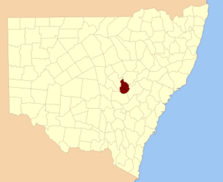
Evelyn County is one of the 141 Cadastral divisions of New South Wales, Australia.

Farnell County Cadastral in New South Wales, Australia

Farnell County is one of the 141 Cadastral divisions of New South Wales.

Gordon County, New South Wales Cadastral in New South Wales, Australia

Gordon County is one of the 141 Cadastral divisions of New South Wales. The Macquarie River is the north-eastern boundary.

Gowen County Cadastral in New South Wales, Australia

Gowen County is one of the 141 Cadastral divisions of New South Wales. It is located to the east of the Castlereagh River in the area to the east of Gilgandra, to Coonabarabran in the north-east. This includes land on both sides of the Newell Highway.

Kennedy County Cadastral in New South Wales, Australia

Kennedy County is one of the 141 Cadastral divisions of New South Wales. It is located to the west of the Bogan River in the area around Tottenham and Tullamore.

Mootwingee County Cadastral in New South Wales, Australia

Mootwingee County, New South Wales is one of the 141 cadastral divisions of New South Wales.

Mouramba County Cadastral in New South Wales, Australia

Mouramba County is one of the 141 Cadastral divisions of New South Wales.

Napier County Cadastral in New South Wales, Australia

Napier County is one of the 141 Cadastral divisions of New South Wales.

Oxley County Cadastral in New South Wales, Australia

Oxley County, New South Wales is one of the 141 Cadastral divisions of New South Wales. It is located between the Bogan River on the west, and the Macquarie River on the east. This is the area approximately between Warren and Nyngan.

Fitzroy Falls, New South Wales Place in New South Wales, Australia

Fitzroy Falls is a village in the Wingecarribee Shire, located within the Southern Highlands region of New South Wales, Australia. The locality was known as Yarrunga, but was renamed after the 81-metre (266 ft) waterfall. At the 2016 census, Fitzroy Falls had a population of 216.

Dangarsleigh, New South Wales Town in New South Wales, Australia

Dangarsleigh is a rural locality and minor trigonometrical station about 11 km south east of Armidale, New South Wales. The locality is at an altitude of about 1,020 metres on the Northern Tablelands in the New England region of New South Wales, Australia. The name Dangarsleigh commemorates the surveyor and pastoralist Henry Dangar’s name. It is within the Armidale Regional Council local government area and Sandon County.

Albert, New South Wales Town in New South Wales, Australia

Albert is a town in the Central West region of New South Wales, Australia. The town is in the Lachlan Shire local government area, 481 kilometres (299 mi) west north west of the state capital, Sydney. At the 2016 census, Albert had a population of 81, though Albert once had a population of 900.

Sandon River, an open mature wave dominated, barrier estuary, is located in the Northern Rivers region of New South Wales, Australia.

References

  1. "Sandon County". Geographical Names Register (GNR) of NSW. Geographical Names Board of New South Wales. OOjs UI icon edit-ltr-progressive.svg Geographical Names Board of NSW]