Narromine County

Last updated

Map all coordinates using: OpenStreetMap  
Download coordinates as: KML  ·  GPX
Narromine
New South Wales
Narromine NSW.PNG
Location in New South Wales
Lands administrative divisions around Narromine:
Oxley Ewenmar Lincoln
Kennedy Narromine Gordon
Kennedy Kennedy Gordon

Narromine County is one of the 141 Cadastral divisions of New South Wales. It is located between the Bogan River on the west and the Macquarie River on the east, in the area around Narromine.

Bogan River river

Bogan River, a perennial river that is part of the Macquarie–Barwon catchment within the Murray–Darling basin, is located in the central west and Orana regions of New South Wales, Australia.

Macquarie River river in New South Wales, Australia

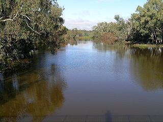
Macquarie River a watercourse that is part of the Macquarie–Barwon catchment within the Murray–Darling basin, is one of the main inland rivers in New South Wales, Australia.

Narromine Town in New South Wales, Australia

Narromine is a town located about 40 kilometres (25 mi) west of Dubbo in the Orana region of New South Wales, Australia. It is the centre of Narromine Shire. At the 2016 census, Narromine had a population of 3,528. The area is a popular area for gliding and the growing of citrus fruits. The Macquarie River passes through the town. The main road from Dubbo to the west also passes through, this being the Mitchell Highway named after the early explorer Sir Thomas Mitchell. Narromine is a station on the Main Western railway line. The area is characterised by hot summers and mild winters.

Narromine is believed to be derived from a local Aboriginal word. [1]

Indigenous Australians are the Aboriginal and Torres Strait Islander peoples of Australia, descended from groups that existed in Australia and surrounding islands before British colonisation. The time of arrival of the first Indigenous peoples on the continent and nearby islands is a matter of debate among researchers. The earliest conclusively human remains found in Australia are those of Mungo Man LM3 and Mungo Lady, which have been dated to around 50,000 years BP. Recent archaeological evidence from the analysis of charcoal and artefacts revealing human use suggests a date as early as 65,000 BP. Luminescence dating has suggested habitation in Arnhem Land as far back as 60,000 years BP. Genetic research has inferred a date of habitation as early as 80,000 years BP. Other estimates have ranged up to 100,000 years and 125,000 years BP.

Parishes within this county

A full list of parishes found within this county; their current LGA and mapping coordinates to the approximate centre of each location is as follows:

Local government in Australia

Local government in Australia is the third tier of government in Australia administered by the states and territories, which in turn are beneath the federal tier. Local government is not mentioned in the Constitution of Australia and two referenda in the 1970s and 1980s to alter the Constitution relating to local government were unsuccessful. Every state government recognises local government in their respective constitutions. Unlike Canada or the United States, there is only one level of local government in each state, with no distinction such as cities and counties.

ParishLGACoordinates
Algalah Narromine Shire 32°14′54″S147°49′04″E / 32.24833°S 147.81778°E / -32.24833; 147.81778 (Algalah)
Backwater Narromine Shire 32°13′54″S148°08′04″E / 32.23167°S 148.13444°E / -32.23167; 148.13444 (Backwater)
Barton Narromine Shire 32°10′54″S147°53′04″E / 32.18167°S 147.88444°E / -32.18167; 147.88444 (Barton)
Biridoo Narromine Shire 32°32′54″S148°21′04″E / 32.54833°S 148.35111°E / -32.54833; 148.35111 (Biridoo)
Buddah Narromine Shire 32°05′54″S148°10′04″E / 32.09833°S 148.16778°E / -32.09833; 148.16778 (Buddah)
Bulgandramine Narromine Shire 32°37′54″S148°12′04″E / 32.63167°S 148.20111°E / -32.63167; 148.20111 (Bulgandramine)
Burrabadine Dubbo Regional Council 32°12′54″S148°30′04″E / 32.21500°S 148.50111°E / -32.21500; 148.50111 (Burrabadine)
Caloma Narromine Shire 32°38′54″S148°18′04″E / 32.64833°S 148.30111°E / -32.64833; 148.30111 (Caloma)
Cathundril Narromine Shire 32°05′54″S146°42′04″E / 32.09833°S 146.70111°E / -32.09833; 146.70111 (Cathundril)
Cowal Narromine Shire 32°12′54″S148°00′04″E / 32.21500°S 148.00111°E / -32.21500; 148.00111 (Cowal)
Dandaloo Narromine Shire 32°10′54″S147°41′04″E / 32.18167°S 147.68444°E / -32.18167; 147.68444 (Dandaloo)
Deribong Narromine Shire 32°11′54″S147°47′04″E / 32.19833°S 147.78444°E / -32.19833; 147.78444 (Deribong)
Doonside Narromine Shire 32°14′54″S147°53′04″E / 32.24833°S 147.88444°E / -32.24833; 147.88444 (Doonside)
Draggy Narromine Shire 32°22′54″S147°52′04″E / 32.38167°S 147.86778°E / -32.38167; 147.86778 (Draggy)
Dungary Dubbo Regional Council 32°17′54″S148°28′04″E / 32.29833°S 148.46778°E / -32.29833; 148.46778 (Dungary)
Enerweena Narromine Shire 32°26′54″S147°58′04″E / 32.44833°S 147.96778°E / -32.44833; 147.96778 (Enerweena)
Enmore Narromine Shire 32°05′54″S147°48′04″E / 32.09833°S 147.80111°E / -32.09833; 147.80111 (Enmore)
Frost Narromine Shire 32°21′54″S148°10′04″E / 32.36500°S 148.16778°E / -32.36500; 148.16778 (Frost)
Gilmour Narromine Shire 32°33′54″S148°05′04″E / 32.56500°S 148.08444°E / -32.56500; 148.08444 (Gilmour)
Gin Gin Narromine Shire 32°00′54″S148°03′04″E / 32.01500°S 148.05111°E / -32.01500; 148.05111 (Gin Gin)
Gin Gin Warren Shire 31°55′54″S147°58′04″E / 31.93167°S 147.96778°E / -31.93167; 147.96778 (Gin Gin)
Goan Narromine Shire 32°03′54″S148°00′04″E / 32.06500°S 148.00111°E / -32.06500; 148.00111 (Goan)
Gradell Narromine Shire 32°30′54″S148°03′04″E / 32.51500°S 148.05111°E / -32.51500; 148.05111 (Gradell)
Gundong Narromine Shire 32°33′56″S148°12′46″E / 32.56556°S 148.21278°E / -32.56556; 148.21278 (Gundong)
Hervey Parkes Shire 32°42′54″S148°17′04″E / 32.71500°S 148.28444°E / -32.71500; 148.28444 (Hervey)
Meringo Narromine Shire 31°59′54″S147°46′04″E / 31.99833°S 147.76778°E / -31.99833; 147.76778 (Meringo)
Mingelo Parkes Shire 32°47′54″S148°11′04″E / 32.79833°S 148.18444°E / -32.79833; 148.18444 (Mingelo)
Minore Dubbo Regional Council 32°11′54″S148°25′04″E / 32.19833°S 148.41778°E / -32.19833; 148.41778 (Minore)
Momo Narromine Shire 32°24′54″S148°21′04″E / 32.41500°S 148.35111°E / -32.41500; 148.35111 (Momo)
Mullah Back Narromine Shire 31°59′54″S147°56′04″E / 31.99833°S 147.93444°E / -31.99833; 147.93444 (Mullah Back)
Mullah Narromine Shire 31°53′54″S147°56′04″E / 31.89833°S 147.93444°E / -31.89833; 147.93444 (Mullah)
Myall Camp Narromine Shire 32°20′54″S148°04′04″E / 32.34833°S 148.06778°E / -32.34833; 148.06778 (Myall Camp)
Narromine Narromine Shire 32°17′54″S148°20′04″E / 32.29833°S 148.33444°E / -32.29833; 148.33444 (Narromine)
Nelson Narromine Shire 32°21′54″S148°00′04″E / 32.36500°S 148.00111°E / -32.36500; 148.00111 (Nelson)
Obley Narromine Shire 32°21′54″S148°16′04″E / 32.36500°S 148.26778°E / -32.36500; 148.26778 (Obley)
Temoin Narromine Shire 32°06′54″S147°56′04″E / 32.11500°S 147.93444°E / -32.11500; 147.93444 (Temoin)
The Oaks Narromine Shire 32°30′54″S148°09′04″E / 32.51500°S 148.15111°E / -32.51500; 148.15111 (The Oaks)
Timbrebongie Narromine Shire 32°10′54″S148°09′04″E / 32.18167°S 148.15111°E / -32.18167; 148.15111 (Timbrebongie)
Tomingley Narromine Shire 32°29′54″S148°16′04″E / 32.49833°S 148.26778°E / -32.49833; 148.26778 (Tomingley)
Trangie Narromine Shire 32°02′54″S147°53′04″E / 32.04833°S 147.88444°E / -32.04833; 147.88444 (Trangie)
Turribung Narromine Shire 32°14′54″S147°41′04″E / 32.24833°S 147.68444°E / -32.24833; 147.68444 (Turribung)
Tyrie Narromine Shire 32°08′54″S147°36′04″E / 32.14833°S 147.60111°E / -32.14833; 147.60111 (Tyrie)
Waterloo Narromine Shire 32°22′54″S147°45′04″E / 32.38167°S 147.75111°E / -32.38167; 147.75111 (Waterloo)
Weemabah Narromine Shire 32°00′54″S148°11′04″E / 32.01500°S 148.18444°E / -32.01500; 148.18444 (Weemabah)
Wentworth Narromine Shire 32°13′54″S148°15′04″E / 32.23167°S 148.25111°E / -32.23167; 148.25111 (Wentworth)
Willydah Narromine Shire 32°07′54″S148°00′04″E / 32.13167°S 148.00111°E / -32.13167; 148.00111 (Willydah)
Yarradigerie Narromine Shire 32°11′54″S147°32′04″E / 32.19833°S 147.53444°E / -32.19833; 147.53444 (Yarradigerie)

Related Research Articles

Narromine Shire Local government area in New South Wales, Australia

Narromine Shire is a local government area in the Orana region of New South Wales, Australia. The Shire is located adjacent to the Mitchell Highway and the Main Western railway line.

Parish of Doonside Cadastral in New South Wales, Australia

The parish of Doonside is an Australian cadastral parish in the NSW county of Narromine. It is located approximately midway between Tottenham and Narromine and is in Narromine Shire. The parish should not be confused with the western Sydney suburb of Doonside.

Parish of Algalah Town in New South Wales, Australia

The parish of Algalah is an Australian cadastral parish in the NSW county of Narromine. It is located 367km west north west from Sydney approximately midway between Tottenham and Narromine and is in Narromine Shire, at 32°14′54″S147°49′04″E.

Dandaloo Town in New South Wales, Australia

Dandaloo is a rural locality in New South Wales, approximately 370 km north west from Sydney, about 15 km north east of Albert and about 40 km south west of Trangie. It is within the Narromine Council area.

Burroway is a bounded rural locality to the north of Narromine township and east of Buddah in New South Wales, Australia. The area at Latitude 32° 05' 00" S and Longitude 148° 16' 00" E is roughly equivalent to the cadastral parishes of Burroway and Emogandry in the county of Ewenmar and is in Narromine Shire.

Minore, New South Wales Town in New South Wales, Australia

Minore is a village, rural locality in the NSW county of Narromine and is in Dubbo City Council.

<i>Narromine News</i>

The Narromine News is a newspaper published bi-weekly in Narromine, New South Wales, Australia. It was published as the Narromine News and Trangie Advocate from 1896 to 1979 when its name was changed to the Narromine News.

Timbrebongie is a cadastral parish and former village on the Macquarie River to the north of Narromine township in New South Wales, Australia. and Buddah in the county of Ewenmar and is in Narromine Shire. The area is located 11.75km North of Narromine, 26.61 km South East of Trangie and about 340 km northwest of Sydney, New South Wales.

Mingelo is a civil parish of Narromine County in central New South Wales located at the confluence of the Ten Mile Creek and the Bogan River.

Bulgandramine is a rural cadastral parish in Narromine County, NSW, approximately 370 km north west from Sydney, west of Trangie. It is within the Narromine Council area at 32°37′54″S 148°12′04″E. Bulganramine is 239 m above sea level.

Enerweena is a rural cadastral parish in Narromine County NSW, located at 32°26′54″S 147°58′04″ approximately 370km north west from Sydney, about 15 km north east of Albert and about 40km south west of Trangie. It is within the Narromine Council area at 32°37′54″S 148°12′04″E.

Frost Parish is a civil parish of Narromine County, New South Wales

Gilmour, New South Wales is a civil parish of Narromine County located at 32°33′54″S 148°05′04″E on the Bogan River.

Hervey, New South Wales is a civil parish Narromine County west of Peak Hill, New South Wales. The Parish of Hervey is in Parkes Shire located at 32°42′54″S 148°17′04″E.

Carrigan, New South Wales New South Wales, Australia

Carrigan is a rural locality of Narromine Shire and it is a civil parish of County of Ewenmar Carrigan is on the Macquarie River east of Warren, New South Wales.

Weemabah is a civil parish of Narromine County located at 32°00′54″S 148°11′04″E, a cadastral division of New South Wales.

Meringo is a civil parish of Narromine County in central New South Wales.

Backwater is a civil parish of Narromine County, New South Wales

Gundong Parish is a civil parish of Narromine County, New South Wales located at 32°33′56″S 148°12′46″E south of Narromine, New South Wales

References

  1. "Narromine County". Geographical Names Register (GNR) of NSW. Geographical Names Board of New South Wales. OOjs UI icon edit-ltr-progressive.svg