Related Research Articles
Macdonald River, a perennial river that is part of the Namoi catchment within the Murray–Darling basin, is located in the Northern Tablelands district of New South Wales, Australia.
Condoublin was an electoral district of the Legislative Assembly in the Australian state of New South Wales from 1894 to 1901, in the Condobolin area.

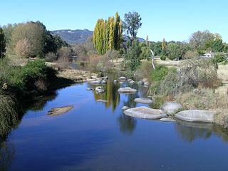
Bendemeer is a village of 485 people on the Macdonald River in the New England region of New South Wales, Australia. It is situated at the junction of the New England and Oxley Highways.
Coxs Creek, a watercourse of the Cooks River catchment, is located in the Inner West of Sydney, in New South Wales, Australia.
Little Nymboida River, a mostly perennial stream of the Clarence River catchment, is located in the Northern Rivers and Northern Tablelands districts of New South Wales, Australia.

Nowendoc River, a perennial river of the Manning River catchment, is located in the Northern Tablelands and Mid North Coast districts of New South Wales, Australia.
Rowleys River, a perennial river of the Manning River catchment, is located in the Northern Tablelands and Mid North Coast districts of New South Wales, Australia.

The parish of Doonside is an Australian cadastral parish in the NSW county of Narromine. It is located approximately midway between Tottenham and Narromine and is in Narromine Shire. The parish should not be confused with the western Sydney suburb of Doonside.
The parish of Algalah is an Australian cadastral parish in the NSW county of Narromine. It is located 367km west north west from Sydney approximately midway between Tottenham and Narromine and is in Narromine Shire, at 32°14′54″S147°49′04″E.

The Back Creek, a perennial stream of the Richmond River catchment, is located in Northern Rivers region in the state of New South Wales, Australia.
Mingelo is a civil parish of Narromine County in central New South Wales located at the confluence of the Ten Mile Creek and the Bogan River.
Bulgandramine is a rural cadastral parish in Narromine County, NSW, approximately 370 km north west from Sydney, west of Trangie. It is within the Narromine Council area at 32°37′54″S 148°12′04″E. Bulganramine is 239 m above sea level.
Enerweena is a rural cadastral parish in Narromine County NSW, located at 32°26′54″S 147°58′04″ approximately 370km north west from Sydney, about 15 km north east of Albert and about 40km south west of Trangie. It is within the Narromine Council area at 32°37′54″S 148°12′04″E.
Frost Parish is a civil parish of Narromine County, New South Wales
Gilmour, New South Wales is a civil parish of Narromine County located at 32°33′54″S 148°05′04″E on the Bogan River.
Hervey, New South Wales is a civil parish Narromine County west of Peak Hill, New South Wales. The Parish of Hervey is in Parkes Shire located at 32°42′54″S 148°17′04″E.
Weemabah is a civil parish of Narromine County located at 32°00′54″S 148°11′04″E, a cadastral division of New South Wales.
Meringo is a civil parish of Narromine County in central New South Wales.
Gundong Parish is a civil parish of Narromine County, New South Wales located at 32°33′56″S 148°12′46″E south of Narromine, New South Wales

Narromine Parish is a civil parish of Oxley County, New South Wales. It is located in Warren Shire at 31°51′54″S 147°50′04″E. The Parish is some kilometers from the town of Narromine which is in the adjoining Narromine County.
References
- ↑ Robert McLean, The New atlas of Australia : the complete work containing over one hundred maps and full descriptive geography of New South Wales, Victoria, Queensland, South Australia and Western Australia, together with numerous illustrations and copious indices (Sydney :J. Sands, [1886) Map 14.
- ↑ Department of Lands, [1961] Map of the County of Narromine, Central Division, N.S.W.
Coordinates: 30°04′S151°53′E / 30.067°S 151.883°E
| This Central West geography article is a stub. You can help Wikipedia by expanding it. |