Robinson County

Last updated

Map all coordinates using: OpenStreetMap  
Download coordinates as: KML  ·  GPX
Robinson
New South Wales
Robinson NSW.PNG
Location in New South Wales
Lands administrative divisions around Robinson:
Yanda Yanda Cowper
Rankin Robinson Canbelego
Booroondarra Mouramba Flinders

Robinson County is one of the 141 Cadastral divisions of New South Wales. It is centred on Cobar.

Robinson County was named in honour of Sir Hercules George Robert Robinson, First Baron Rosmead (1824-1897). [1]

Hercules Robinson, 1st Baron Rosmead 5th Governor of Hong Kong

Hercules George Robert Robinson, 1st Baron Rosmead,, was a British colonial administrator who became the 5th Governor of Hong Kong and subsequently, the 14th Governor of New South Wales, the first Governor of Fiji, and the 8th Governor of New Zealand. From June 1859 until August 1896, he was known as Sir Hercules Robinson.

Parishes within this county

A full list of parishes found within this county; their current LGA and mapping coordinates to the approximate centre of each location is as follows:

Local government in Australia

Local government in Australia is the third tier of government in Australia administered by the states and territories, which in turn are beneath the federal tier. Local government is not mentioned in the Constitution of Australia and two referenda in the 1970s and 1980s to alter the Constitution relating to local government were unsuccessful. Every state government recognises local government in their respective constitutions. Unlike Canada or the United States, there is only one level of local government in each state, with no distinction such as cities and counties.

ParishLGACoordinates
Amphitheatre Cobar Shire 31°30′41″S145°30′49″E / 31.51139°S 145.51361°E / -31.51139; 145.51361 (Amphitheatre)
Balah Cobar Shire 31°33′33″S145°34′38″E / 31.55917°S 145.57722°E / -31.55917; 145.57722 (Balah)
Baroora Cobar Shire 31°47′27″S145°45′17″E / 31.79083°S 145.75472°E / -31.79083; 145.75472 (Baroora)
Bee Cobar Shire 31°42′16″S146°00′07″E / 31.70444°S 146.00194°E / -31.70444; 146.00194 (Bee)
Billagoe Cobar Shire 31°15′26″S145°51′48″E / 31.25722°S 145.86333°E / -31.25722; 145.86333 (Billagoe)
Booroomugga Cobar Shire 31°16′13″S146°01′15″E / 31.27028°S 146.02083°E / -31.27028; 146.02083 (Booroomugga)
Booroondarra Cobar Shire 31°12′13″S145°37′44″E / 31.20361°S 145.62889°E / -31.20361; 145.62889 (Booroondarra)
Buckambool Cobar Shire unknown
Buckwaroon Cobar Shire unknown
Chesney Cobar Shire 31°07′11″S145°46′49″E / 31.11972°S 145.78028°E / -31.11972; 145.78028 (Chesney)
Cobar Cobar Shire 31°30′21″S145°49′59″E / 31.50583°S 145.83306°E / -31.50583; 145.83306 (Cobar)
Cohn Cobar Shire 31°32′54″S146°13′31″E / 31.54833°S 146.22528°E / -31.54833; 146.22528 (Cohn)
Coonumberto Cobar Shire 31°19′00″S145°44′22″E / 31.31667°S 145.73944°E / -31.31667; 145.73944 (Coonumberto)
Coonumberto Cobar Shire 31°19′24″S145°38′49″E / 31.32333°S 145.64694°E / -31.32333; 145.64694 (Coonumberto)
Coronga Cobar Shire 31°09′54″S145°57′04″E / 31.16500°S 145.95111°E / -31.16500; 145.95111 (Coronga)
Coronga Cobar Shire 31°11′48″S145°59′39″E / 31.19667°S 145.99417°E / -31.19667; 145.99417 (Coronga)
Cuttagullyaroo Cobar Shire 31°16′09″S145°40′15″E / 31.26917°S 145.67083°E / -31.26917; 145.67083 (Cuttagullyaroo)
Cuttagullyaroo Cobar Shire 31°17′19″S145°36′04″E / 31.28861°S 145.60111°E / -31.28861; 145.60111 (Cuttagullyaroo)
Davies Cobar Shire 31°20′26″S145°55′45″E / 31.34056°S 145.92917°E / -31.34056; 145.92917 (Davies)
Gidda Cobar Shire 31°09′21″S145°43′50″E / 31.15583°S 145.73056°E / -31.15583; 145.73056 (Gidda)
Gidgie Cobar Shire 31°29′41″S145°22′13″E / 31.49472°S 145.37028°E / -31.49472; 145.37028 (Gidgie)
Grawlin Cobar Shire 31°27′23″S145°37′26″E / 31.45639°S 145.62389°E / -31.45639; 145.62389 (Grawlin)
Hillston Cobar Shire 31°35′56″S145°50′09″E / 31.59889°S 145.83583°E / -31.59889; 145.83583 (Hillston)
Hoskins Cobar Shire 31°24′07″S146°05′55″E / 31.40194°S 146.09861°E / -31.40194; 146.09861 (Hoskins)
Kaloogleguy Cobar Shire 31°24′06″S145°48′04″E / 31.40167°S 145.80111°E / -31.40167; 145.80111 (Kaloogleguy)
Kaloogleguy Cobar Shire 31°27′24″S145°46′04″E / 31.45667°S 145.76778°E / -31.45667; 145.76778 (Kaloogleguy)
Kiantharillany Cobar Shire 31°20′54″S145°36′04″E / 31.34833°S 145.60111°E / -31.34833; 145.60111 (Kiantharillany)
Lambrigg Cobar Shire 31°30′12″S146°10′24″E / 31.50333°S 146.17333°E / -31.50333; 146.17333 (Lambrigg)
Lerida Cobar Shire 31°42′38″S145°41′00″E / 31.71056°S 145.68333°E / -31.71056; 145.68333 (Lerida)
Linton Cobar Shire 31°29′40″S145°56′48″E / 31.49444°S 145.94667°E / -31.49444; 145.94667 (Linton)
Louth Cobar Shire 31°18′47″S145°32′54″E / 31.31306°S 145.54833°E / -31.31306; 145.54833 (Louth)
Louth Cobar Shire 31°21′24″S145°30′34″E / 31.35667°S 145.50944°E / -31.35667; 145.50944 (Louth)
Mopone Cobar Shire 31°24′24″S145°52′04″E / 31.40667°S 145.86778°E / -31.40667; 145.86778 (Mopone)
Moquilamba Cobar Shire unknown
Moquilamba Cobar Shire 31°13′39″S145°46′29″E / 31.22750°S 145.77472°E / -31.22750; 145.77472 (Moquilamba)
Mulga Cobar Shire unknown
Mullimut Cobar Shire 31°22′03″S145°48′09″E / 31.36750°S 145.80250°E / -31.36750; 145.80250 (Mullimut)
Mumbowanna Cobar Shire 31°19′03″S145°20′31″E / 31.31750°S 145.34194°E / -31.31750; 145.34194 (Mumbowanna)
Narri Cobar Shire 31°38′12″S145°58′10″E / 31.63667°S 145.96944°E / -31.63667; 145.96944 (Narri)
Nyngan Cobar Shire 31°24′57″S145°59′00″E / 31.41583°S 145.98333°E / -31.41583; 145.98333 (Nyngan)
Priory Cobar Shire unknown
Rochford Cobar Shire 31°38′27″S146°07′20″E / 31.64083°S 146.12222°E / -31.64083; 146.12222 (Rochford)
Tambua Cobar Shire 31°22′39″S145°15′54″E / 31.37750°S 145.26500°E / -31.37750; 145.26500 (Tambua)
Tindayrey Cobar Shire 31°07′57″S145°57′12″E / 31.13250°S 145.95333°E / -31.13250; 145.95333 (Tindayrey)
Tindayrey Cobar Shire 31°08′24″S145°53′29″E / 31.14000°S 145.89139°E / -31.14000; 145.89139 (Tindayrey)
Toy Cobar Shire 31°28′54″S145°44′04″E / 31.48167°S 145.73444°E / -31.48167; 145.73444 (Toy)
Walshe Cobar Shire 31°25′45″S145°25′46″E / 31.42917°S 145.42944°E / -31.42917; 145.42944 (Walshe)
Weltie Cobar Shire 31°33′42″S145°57′21″E / 31.56167°S 145.95583°E / -31.56167; 145.95583 (Weltie)
Winbar Cobar Shire 31°14′56″S145°30′45″E / 31.24889°S 145.51250°E / -31.24889; 145.51250 (Winbar)
Yanda Cobar Shire 31°34′51″S146°04′22″E / 31.58083°S 146.07278°E / -31.58083; 146.07278 (Yanda)

Related Research Articles

Gloucester County, New South Wales Cadastral in New South Wales, Australia

Gloucester County was one of the original Nineteen Counties in New South Wales, and is now one of the 141 cadastral divisions of New South Wales. It includes the area around Port Stephens. It is bounded on the north and west by the Manning River, and on the south-west by the Williams River.

Camden County, New South Wales Cadastral in New South Wales, Australia

Camden County was one of the original Nineteen Counties in New South Wales and is now one of the 141 Cadastral divisions of New South Wales. It included the coastal area near Wollongong south to the Shoalhaven River, and also inland encompassing Berrima and Picton. Its western boundary was the Wollondilly River. The first settlement in the area was Camden Park, established by John Macarthur in 1806, just across the Nepean River from Cumberland County. It was the first land across the Nepean to be settled. Camden is a present-day suburb of Sydney in the same area, although parts of it are in Cumberland.

St Vincent County Cadastral in Australian Capital Territory

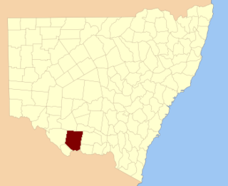
St Vincent County was one of the original Nineteen Counties in New South Wales and is now one of the 141 Cadastral divisions of New South Wales. It included the south coast area encompassing Batemans Bay, Ulladulla, Jervis Bay and inland to Braidwood. The Shoalhaven River is the boundary to the north and west, and the Deua River the boundary to the south.

Townsend County Cadastral in New South Wales, Australia

Townsend County is one of the 141 Cadastral divisions of New South Wales. It is in the south of New South Wales with the Murray River to the south. Deniliquin is located there.

Sandon County Cadastral in New South Wales, Australia

Sandon County is one of the 141 Cadastral divisions of New South Wales. It is centred on Armidale, and also includes Uralla.

Cooper County, New South Wales Cadastral in New South Wales, Australia

Cooper County is one of the 141 Cadastral divisions of New South Wales. It contains the town of Barellan. The Murrumbidgee River is the southern boundary.

Harden County Cadastral in New South Wales, Australia

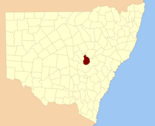
Harden County is one of the 141 cadastral divisions of New South Wales. It contains the town of Harden.

Clarendon County, New South Wales Cadastral in New South Wales, Australia

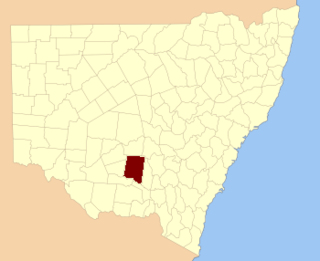
Clarendon County is one of the 141 Cadastral divisions of New South Wales. It contains the towns of Gundagai, Junee and Bethungra. The Murrumbidgee River is the boundary to the south.

Cowper County Cadastral in New South Wales, Australia

Cowper County, New South Wales is one of the 141 Cadastral divisions of New South Wales.

Delalah County Cadastral in New South Wales, Australia

Delalah County is one of the 141 Cadastral divisions of New South Wales.

Evelyn County, New South Wales Cadastral in New South Wales, Australia

Evelyn County is one of the 141 Cadastral divisions of New South Wales, Australia.

Gordon County, New South Wales Cadastral in New South Wales, Australia

Gordon County is one of the 141 Cadastral divisions of New South Wales. The Macquarie River is the north-eastern boundary.

Gowen County Cadastral in New South Wales, Australia

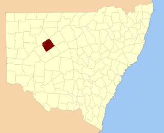
Gowen County is one of the 141 Cadastral divisions of New South Wales. It is located to the east of the Castlereagh River in the area to the east of Gilgandra, to Coonabarabran in the north-east. This includes land on both sides of the Newell Highway.

Irrara County Cadastral in New South Wales, Australia

Irrara County is one of the 141 Cadastral divisions of New South Wales. It is located south of the border with Queensland, east of the Paroo River, and west of the Warrego River.

Kennedy County Cadastral in New South Wales, Australia

Kennedy County is one of the 141 Cadastral divisions of New South Wales. It is located to the west of the Bogan River in the area around Tottenham and Tullamore.

Mootwingee County Cadastral in New South Wales, Australia

Mootwingee County, New South Wales is one of the 141 Cadastral divisions of New South Wales.

Napier County Cadastral in New South Wales, Australia

Napier County is one of the 141 Cadastral divisions of New South Wales.

Oxley County Cadastral in New South Wales, Australia

Oxley County, New South Wales is one of the 141 Cadastral divisions of New South Wales. It is located between the Bogan River on the west, and the Macquarie River on the east. This is the area approximately between Warren and Nyngan.

Rankin County, New South Wales Cadastral in New South Wales, Australia

Rankin County is one of the 141 Cadastral divisions of New South Wales. It includes part of the Paroo-Darling National Park. The border to the north-west is the Darling River.

Yungnulgra County Cadastral in New South Wales, Australia

Yungnulgra County is one of the 141 Cadastral divisions of New South Wales.

References

  1. "Robinson". Geographical Names Register (GNR) of NSW. Geographical Names Board of New South Wales . Retrieved 4 August 2013. OOjs UI icon edit-ltr-progressive.svg