Amphitheatre Parish is a civil parish of Robinson County, New South Wales, Australia.
Amphitheatre Parish is a civil parish of Robinson County, New South Wales, Australia.
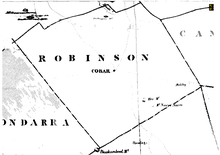
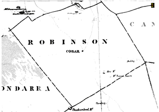
The parish is located on the Barrier Highway between Cubba and Cobar. [1] The parish on Buckwaroon Creek has a flat topography and is vegetated by a sparse shrub cover.

Hercules George Robert Robinson, 1st Baron Rosmead,, was a British colonial administrator who became the 5th Governor of Hong Kong and subsequently, the 14th Governor of New South Wales, the first Governor of Fiji, and the 8th Governor of New Zealand. From June 1859 until August 1896, he was known as Sir Hercules Robinson.

Blaenau Gwent is a county borough in the south-east of Wales. It borders the unitary authority areas of Monmouthshire and Torfaen to the east, Caerphilly to the west and Powys to the north. Its main towns are Abertillery, Brynmawr, Ebbw Vale and Tredegar. Its highest point is Coity Mountain at 1,896 feet (578 m).
Until 1974, Monmouthshire, also formerly known as the County of Monmouth, was an administrative county in the south-east of Wales, on the border with England, and later classed as one of the thirteen historic counties of Wales. Its area now corresponds approximately to the present principal areas of Monmouthshire, Blaenau Gwent, Newport and Torfaen, and those parts of Caerphilly and Cardiff east of the Rhymney River.

Cumberland County is a county in the State of New South Wales, Australia. Most of the Sydney metropolitan area is located within the County of Cumberland.
A parish is an administrative division used by several countries. To distinguish it from an ecclesiastical parish, the term civil parish is used in some jurisdictions, as noted below.
The Diocese of Canberra and Goulburn is one of the 23 dioceses of the Anglican Church of Australia. The diocese has 60 parishes covering most of south-east New South Wales, the eastern Riverina and the Australian Capital Territory (ACT). It stretches from Marulan in the north, from Batemans Bay to Eden on the south coast across to Holbrook in the south-west, north to Wagga Wagga, Temora, Young and Goulburn.
Newcastle usually refers to:

Darbalara is a rural community on the east bank of the junction of the Murrumbidgee River and Tumut River in the Riverina. It is situated by road, about 25 kilometres north east of Gundagai and 25 kilometres south of Coolac.

For lands administrative purposes, New South Wales is divided into 141 counties, which are further divided into parishes. The counties were first set down in the Colony of New South Wales, which later became the Australian state of New South Wales.

Lands administrative divisions of Australia are the cadastral divisions of Australia for the purposes of identification of land to ensure security of land ownership. Most states term these divisions as counties, parishes, hundreds, and other terms. The eastern states of Queensland, New South Wales, Victoria, and Tasmania were divided into counties and parishes in the 19th century, although the Tasmanian counties were renamed land districts in the 20th century. Parts of South Australia (south-east) and Western Australia (south-west) were similarly divided into counties, and there were also five counties in a small part of the Northern Territory. However South Australia has subdivisions of hundreds instead of parishes, along with the Northern Territory, which was part of South Australia when the hundreds were proclaimed. There were also formerly hundreds in Tasmania. There have been at least 600 counties, 544 hundreds and at least 15,692 parishes in Australia, but there are none of these units for most of the sparsely inhabited central and western parts of the country.

Gloucester County was one of the original Nineteen Counties in New South Wales, and is now one of the 141 cadastral divisions of New South Wales. It includes the area around Port Stephens. It is bounded on the north and west by the Manning River, and on the south-west by the Williams River.

St Vincent County was one of the original Nineteen Counties in New South Wales and is now one of the 141 Cadastral divisions of New South Wales. It included the south coast area encompassing Batemans Bay, Ulladulla, Jervis Bay and inland to Braidwood. The Shoalhaven River is the boundary to the north and west, and the Deua River the boundary to the south.

Yancowinna County is one of the 141 Cadastral divisions of New South Wales.

Blaxland County is one of the 141 Cadastral divisions of New South Wales. It is bounded to the south by the Lachlan River and a small part of Waverley Creek. It includes Mount Hope and the Nombinnie Nature Reserve.

Mootwingee County, New South Wales is one of the 141 cadastral divisions of New South Wales.
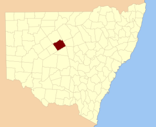
Robinson County is one of the 141 Cadastral divisions of New South Wales. It is centred on Cobar.

St Philip's Church, Sydney, is the oldest Anglican church parish in Australia. The church is located in the Sydney city centre between York Street, Clarence and Jamison Streets on a location known as Church Hill. It is one of two churches in the Anglican Parish of Church Hill. Together, they are known as Church Hill Anglican. St Philip's is part of the Diocese of Sydney, Australia. The church is listed on the Register of the National Estate.

St Thomas' Anglican Church is a heritage-listed Anglican church located in the western Sydney suburb of Mulgoa in the City of Penrith local government area of New South Wales, Australia. The church forms part of the Diocese of Sydney. It was designed by Reverend Thomas Makinson, first incumbent priest and James Chadley and built from 1836 to 1838 by James Atkinson and William Chisholm. It is also known as St. Thomas Anglican Church and St Thomas Church of England. The property is owned by Anglican Church Property Trust. It was added to the New South Wales State Heritage Register on 2 April 1999.
Nyngan Parish is a civil parish of Robinson County, a cadastral division of New South Wales. It is located on Yanda Creek and the Kidman Way north east of Cobar, New South Wales.
Bee Parish, New South Wales is a rural locality of Cobar Shire and a civil parish of Robinson County.
| | This New South Wales geography article is a stub. You can help Wikipedia by expanding it. |