Cowley County, New South Wales

Last updated
Map all coordinates using: OpenStreetMap  ·  Google Maps
Download coordinates as: KML  ·  GPX
Cowley
New South Wales

Cowley NSW.PNG

Location in New South Wales
Lands administrative divisions around Cowley:
Harden Harden Murray
Buccleuch Cowley Murray
Wallace Wallace Beresford
Looking south near the Tharwa Bridge; the Murrumbidgee River formed the boundary between Murray, on the left and Cowley on the right. This land is now part of the Australian Capital Territory and not in any county. Murrumbidgee river tharwa bridge.jpg
Looking south near the Tharwa Bridge; the Murrumbidgee River formed the boundary between Murray, on the left and Cowley on the right. This land is now part of the Australian Capital Territory and not in any county.
Map showing parishes in the ACT area. Cowley County shown in yellow. Australian Capital Territory parishes.png
Map showing parishes in the ACT area. Cowley County shown in yellow.
The Goodradigbee River in the Brindabella Ranges; the river was the western boundary between Cowley (left) and Buccleuch (right) BrindabellaValleyAndGoodradigbeeRiver.jpg
The Goodradigbee River in the Brindabella Ranges; the river was the western boundary between Cowley (left) and Buccleuch (right)

Cowley County is one of the 141 Cadastral divisions of New South Wales. It contains the locality of Cavan. It was originally bordered on the north, east and part of the south by the Murrumbidgee River, and on the west by the Goodradigbee River. A large part of the county was transferred to the Commonwealth to make the Australian Capital Territory in 1909, with the remaining part the area to the north-west of the ACT as far north as the Burrinjuck Dam, and thin strips of land along the western, southern and south-eastern borders of the ACT.

Cavan, New South Wales Town in New South Wales, Australia

Cavan is a rural community situated on the south bank of the Murrumbidgee River in the Yass Valley Shire. At the 2016 census, it had a population of 47. It is situated by road, about 40 kilometres southwest of Yass and 43 northwest of Canberra. It was named after the town of Cavan in Ireland.

Murrumbidgee River river in New South Wales, Australia

Murrumbidgee River, a major tributary of the Murray River within the Murray–Darling basin and the second longest river in Australia. It flows through the Australian state of New South Wales and the Australian Capital Territory. It descends 1,500 metres (4,900 ft) as it flows 1,485 kilometres (923 mi) in a west-northwesterly direction from the foot of Peppercorn Hill in the Fiery Range of the Snowy Mountains towards its confluence with the Murray River near Boundary Bend.

Goodradigbee River river in Australia

Goodradigbee River, a perennial stream that is part of the Murrumbidgee catchment within the Murray–Darling basin, is located in the Snowy Mountains district of New South Wales, Australia.

Cowley County is named in honour of Henry Richard Charles Wellesley, First Earl Cowley (1804-1884). [1]

Henry Wellesley, 1st Earl Cowley British diplomat

Henry Richard Charles Wellesley, 1st Earl Cowley, known as The Lord Cowley between 1847 and 1857, was a British diplomat. He served as British Ambassador to France between 1852 and 1867.

Parishes within this county

A full list of parishes found within this county including the 15 former parishes which are now part of the ACT; their current LGA and mapping coordinates to the approximate centre of each location is as follows:

Local government in Australia

Local government in Australia is the third tier of government in Australia administered by the states and territories, which in turn are beneath the federal tier. Local government is not mentioned in the Constitution of Australia and two referenda in the 1970s and 1980s to alter the Constitution relating to local government were unsuccessful. Every state government recognises local government in their respective constitutions. Unlike Canada or the United States, there is only one level of local government in each state, with no distinction such as cities and counties.

Parish LGA Coordinates
Bimberi Snowy Valleys Council 35°34′54″S148°45′04″E / 35.58167°S 148.75111°E / -35.58167; 148.75111 (Bimberi)
Boboyan (former) Australian Capital Territory
Booroomba (former) Australian Capital Territory
Brayshaw (former) Australian Capital Territory
Brindibella Snowy Valleys Council 35°23′54″S148°46′04″E / 35.39833°S 148.76778°E / -35.39833; 148.76778 (Brindibella)
Bumbalong Snowy Monaro Regional Council 35°48′54″S149°07′04″E / 35.81500°S 149.11778°E / -35.81500; 149.11778 (Bumbalong)
Cavan Yass Valley Council 35°03′54″S148°52′04″E / 35.06500°S 148.86778°E / -35.06500; 148.86778 (Cavan)
Cochran Snowy Monaro Regional Council 35°44′54″S148°53′04″E / 35.74833°S 148.88444°E / -35.74833; 148.88444 (Cochran)
Congwarra (former) Australian Capital Territory
Cooleman Snowy Valleys Council 35°39′54″S148°45′04″E / 35.66500°S 148.75111°E / -35.66500; 148.75111 (Cooleman)
Coree Yass Valley Council 35°16′54″S148°46′04″E / 35.28167°S 148.76778°E / -35.28167; 148.76778 (Coree)
Cotter (former) Australian Capital Territory
Cuppacumbalong Snowy Monaro Regional Council 35°36′54″S149°06′04″E / 35.61500°S 149.10111°E / -35.61500; 149.10111 (Cuppacumbalong)
East Goodradigbee Yass Valley Council 35°07′54″S148°44′04″E / 35.13167°S 148.73444°E / -35.13167; 148.73444 (East Goodradigbee)
Fergus (former) Australian Capital Territory
Gibraltar (former) Australian Capital Territory
Greenfield (former) Australian Capital Territory
Gudgenby (former) Australian Capital Territory
Gurrangora Snowy Monaro Regional Council 35°44′54″S148°45′04″E / 35.74833°S 148.75111°E / -35.74833; 148.75111 (Gurrangora)
Long Plain Snowy Monaro Regional Council 35°39′54″S148°37′04″E / 35.66500°S 148.61778°E / -35.66500; 148.61778 (Long Plain)
Micalong Yass Valley Council 35°13′54″S148°45′04″E / 35.23167°S 148.75111°E / -35.23167; 148.75111 (Micalong)
Milligan (former) Australian Capital Territory
Mullion Yass Valley Council 35°07′54″S148°48′04″E / 35.13167°S 148.80111°E / -35.13167; 148.80111 (Mullion)
Murray Snowy Valleys Council 35°36′54″S148°40′04″E / 35.61500°S 148.66778°E / -35.61500; 148.66778 (Murray)
Naas (former) Australian Capital Territory
Narrangullen Yass Valley Council 34°59′54″S148°43′04″E / 34.99833°S 148.71778°E / -34.99833; 148.71778 (Narrangullen)
Nattung Snowy Monaro Regional Council 35°44′54″S148°36′04″E / 35.74833°S 148.60111°E / -35.74833; 148.60111 (Nattung)
Orroral (former) Australian Capital Territory
Pabral Yass Valley Council 35°13′54″S148°48′04″E / 35.23167°S 148.80111°E / -35.23167; 148.80111 (Pabral)
Punyibah (former) Australian Capital Territory
Taemas Yass Valley Council 35°01′54″S148°46′04″E / 35.03167°S 148.76778°E / -35.03167; 148.76778 (Taemas)
Tharwa (former) Australian Capital Territory
Tidbinbilla (former) Australian Capital Territory
Umburra Yass Valley Council 35°08′54″S148°53′04″E / 35.14833°S 148.88444°E / -35.14833; 148.88444 (Umburra)
Urayarra Yass Valley Council 35°14′54″S148°53′04″E / 35.24833°S 148.88444°E / -35.24833; 148.88444 (Urayarra)
Venterman Snowy Valleys Council 35°29′54″S148°45′04″E / 35.49833°S 148.75111°E / -35.49833; 148.75111 (Venterman)
Yaouk Snowy Monaro Regional Council 35°44′54″S148°48′04″E / 35.74833°S 148.80111°E / -35.74833; 148.80111 (Yaouk)
Yarara Snowy Monaro Regional Council 35°44′54″S149°06′04″E / 35.74833°S 149.10111°E / -35.74833; 149.10111 (Yarara)

Related Research Articles

Uriarra, New South Wales Suburb of Yass Valley Council, New South Wales, Australia

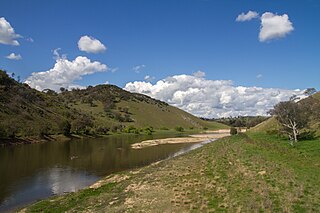
Uriarra is a locality in the Southern Tablelands of New South Wales, Australia in the Yass Valley Shire. It is north of the locality of Uriarra in the Australian Capital Territory and north-east of Canberra. At the 2016 census, it had a population of 30. The locality is mostly located in the Urayarra parish of Cowley County, although part of it in Pabral parish, which lies further west.

The Seat of Government Acceptance Act 1909 is an Australian Commonwealth Government act, that in conjunction with the Seat of Government Surrender Act 1909 transferred land from the state of New South Wales to the Commonwealth for the creation of the Federal Capital Territory.

Lands administrative divisions of Australia

Lands administrative divisions of Australia are the cadastral divisions of Australia for the purposes of identification of land to ensure security of land ownership. Most states term these divisions as counties, parishes, hundreds, and other terms. The eastern states of Queensland, New South Wales, Victoria and Tasmania were divided into counties and parishes in the 19th century, although the Tasmanian counties were renamed land districts in the 20th century. Parts of South Australia (south-east) and Western Australia (south-west) were similarly divided into counties, and there were also five counties in a small part of the Northern Territory. However South Australia has subdivisions of hundreds instead of parishes, along with the Northern Territory, which was part of South Australia when the hundreds were proclaimed. There were also formerly hundreds in Tasmania. There have been at least 600 counties, 544 hundreds and at least 15,692 parishes in Australia, but there are none of these units for most of the sparsely inhabited central and western parts of the country.

St Vincent County Cadastral in New South Wales, Australia

St Vincent County was one of the original Nineteen Counties in New South Wales and is now one of the 141 Cadastral divisions of New South Wales. It included the south coast area encompassing Batemans Bay, Ulladulla, Jervis Bay and inland to Braidwood. The Shoalhaven River is the boundary to the north and west, and the Deua River the boundary to the south.

Murray County, New South Wales Cadastral in New South Wales, Australia

Murray County was one of the original Nineteen Counties in New South Wales and is now one of the 141 Lands administrative divisions of New South Wales. It included the area which is now part of Canberra and as far north as Lake George and Yass. It was originally bounded on the west by the Murrumbidgee River, on the east by the Shoalhaven River and on the north by the Yass River. A large area of the county was transferred to the Commonwealth government in 1909 in the Seat of Government Acceptance Act to make part of the Australian Capital Territory, along with land in Cowley County. Since then, the ACT border is now part of the western boundary. Part of the ACT border is determined by property boundaries in the Parish of Keewong, in the County of Murray; specifically the southern end of portions 177, 218, 211, 36, and 38. This is mentioned in the Seat of Government Acceptance Act of 1909.

Irrara County Cadastral in New South Wales, Australia

Irrara County is one of the 141 Cadastral divisions of New South Wales. It is located south of the border with Queensland, east of the Paroo River, and west of the Warrego River.

Parish of Tuggeranong Cadastral in New South Wales, Australia

Tuggeranong Parish is a parish of Murray County, New South Wales, a cadastral unit for use on land titles. It is now about a third of the size it was in the nineteenth century, after most of the land in the parish was transferred to the Australian Capital Territory in 1911. It currently includes a small section of land in New South Wales between the ACT border and Jerrabomberra Creek, but once included most of what is now the Canberra town centre of Tuggeranong.

Parish of Weetangera Cadastral in New South Wales, Australia

Weetangera Parish is a parish of Murray County, New South Wales, a cadastral unit for use on land titles. It is now very small, after most of the land in the parish was transferred to the Australian Capital Territory in 1911, but it once included the south-west part of what is now the Canberra town centre of Belconnen including the town centre. It currently includes a small section of land in New South Wales between the ACT border, Ginninderra Creek and the Murrumbidgee River.

Parish of Queanbeyan Cadastral in New South Wales, Australia

Queanbeyan Parish is a parish of Murray County, New South Wales, a cadastral unit for use on land titles. It covers the city of Queanbeyan. It was originally bounded by the Molonglo River to the north, but is now bounded by the NSW-ACT border in the north and west. Parts of the western area of the parish were transferred to the Australian Capital Territory in 1909, including what are now the Canberra suburbs of Fyshwick, Narrabundah, Kingston, Oaks Estate, Harman and part of Hume.

Land District of Queanbeyan Cadastral in New South Wales, Australia

The Land District of Queanbeyan was one of the around 100 land districts of New South Wales which were introduced with the Crown Lands Act of 1884. It was based around the town of Queanbeyan, and included the area from near Lake George in the north, to Colinton in the south, and west to the Goodradigbee River and beyond it. In 1909, a large part of the district was transferred to the Commonwealth government to become the Australian Capital Territory.

Bendoc River river in Australia

The Bendoc River is a perennial river of the Snowy River catchment, located in the Alpine regions of the states of Victoria and New South Wales, Australia.

Mullion, New South Wales Suburb of Yass Valley Council, New South Wales, Australia

Mullion is a locality in the Southern Tablelands of New South Wales, Australia in the Yass Valley Shire. It lies north-east of Canberra on the western side of the Murrumbidgee River. At the 2016 census, it had a population of 84. It had a public school from 1959 to 1972. The locality is located in the Umburra parish of Cowley County, with a small part of it in Mullion parish, which lies further west.

Clive, New South Wales is a civil parish of Buccleuch County in New South Wales, Australia.

Blowering, New South Wales

Blowering, New South wales is a rural locality in the Snowy Mountains of New South wales and a civil Parish of Buccleuch County.

Birrema, New South Wales

Birrema, New South Wales is a civil parish of Harden County, New South Wales.

Childowla, New South Wales is a civil parish of Buccleuch County, New South Wales.

Cumbamurra, New South Wales

Cumbamurra, New South Wales is a civil parish of Harden County, New South Wales.

Bramina is a rural locality of the Snowy Mountains and a civil parish of Buccleuch County, New South Wales.

Cromwell Parish is a rural locality of the Snowy Mountains and a civil parish of Buccleuch County, New South Wales.

The Parish of Yarara is a civil parish of Cowley County, New South Wales. The parish is between the Murrumbidgee River and the Australian Capital Territory border and is heavily forested. It lies to the west of Michelago, but is cut off from it by the Murrumbidgee and is only accessible by road from Tharwa or Williamsdale. It forms part of the current locality of Clear Range, which had a population of 36 at the 2016 census.

References

  1. "Cowley County". Geographical Names Register (GNR) of NSW. Geographical Names Board of New South Wales.