Parish of Eurimbula

Last updated

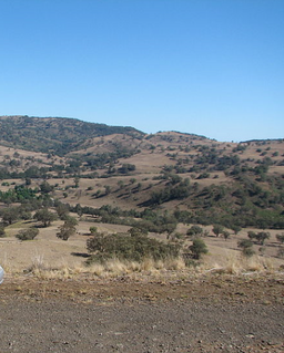
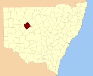
Eurimbula, New South Wales is a civil parish of Gordon County, New South Wales, [1] a Cadastral divisions of New South Wales. [2]

Lands administrative divisions of Australia

Lands administrative divisions of Australia are the cadastral divisions of Australia for the purposes of identification of land to ensure security of land ownership. Most states term these divisions as counties, parishes, hundreds, and other terms. The eastern states of Queensland, New South Wales, Victoria and Tasmania were divided into counties and parishes in the 19th century, although the Tasmanian counties were renamed land districts in the 20th century. Parts of South Australia (south-east) and Western Australia (south-west) were similarly divided into counties, and there were also five counties in a small part of the Northern Territory. However South Australia has subdivisions of hundreds instead of parishes, along with the Northern Territory, which was part of South Australia when the hundreds were proclaimed. There were also formerly hundreds in Tasmania. There have been at least 600 counties, 544 hundreds and at least 15,692 parishes in Australia, but there are none of these units for most of the sparsely inhabited central and western parts of the country.

Gordon County, New South Wales Cadastral in New South Wales, Australia

Gordon County is one of the 141 Cadastral divisions of New South Wales. The Macquarie River is the north-eastern boundary.

Eurimbula, New South Wales is on the Bell River between Molong, New South Wales and Wellington, New South Wales and the Molong–Dubbo railway line passes through the parish. [3]

Bell River, a watercourse that is part of the Macquarie catchment within the Murray–Darling basin, is located in the central west region of New South Wales, Australia.

Wellington, New South Wales Town in New South Wales, Australia

Wellington is a town in inland New South Wales, Australia, located at the junction of the Macquarie and Bell Rivers. It is within the local government area of Dubbo Regional Council. The town is 362 kilometres (225 mi) from Sydney on the Great Western Highway and Mitchell Highway.

The Molong–Dubbo railway line is an inactive railway line in western New South Wales, Australia. It branched off the Broken Hill line at Molong and paralleled the Main West line before rejoining it at Dubbo. The line was designed with gentler grades than the steeper section of the Main Western line via Wellington, but this resulted in it taking a meandering course.

Related Research Articles

Napier Parish, New South Wales

Napier is a rural locality of Warrumbungle Shire Council and a civil parish of Napier County New South Wales. and is at 31°35′54″S149°46′04″E.

Lowe, New South Wales

Lowe Parish is a civil Parish of Napier County, New South Wales.

Morven Parish is a civil parish of County of Napier, a county in the central western part of New South Wales, Australia.

Moorangoorang is a rural locality and a civil parish of County of Napier in the central western part of New South Wales, Australia. The parish has three railway stations, Mooren, Borah and Pimbra.

Butheroo is a civil parish of Napier County, a county of central New South Wales.

Bungabah is a civil parish of Napier County in New South Wales.

Toorawandi Parish (Napier County), New South Wales New South Wales, Australia

Toorawandi is a civil parish of Napier County in New South wales.

Neible Parish, New South Wales is a civil parish of Napier County, a county located in central western New South Wales.

Binnaway Parish, New South Wales New South Wales, Australia

Binnaway Parish is a civil Parish of Napier County, New South Wales, located on the Castlereagh River in central western New South Wales.

Mendooran Parish, New South Wales

Mendooran Parish, New South Wales is a civil parish of Napier County, New South Wales.

Parish of Benolong New South Wales, Australia

Benolong Parish is a civil parish of Gordon County, New South Wales. a Cadastral divisions of New South Wales.

Parish of Terrabella New South Wales, Australia

Terrabella Parish is a civil parish of Gordon County, New South Wales. a Cadastral divisions of New South Wales.

Parish of Ponto New South Wales, Australia

Ponto, New SouthWales is a civil parish of Gordon County, New South Wales. a Cadastral divisions of New South Wales.

Gundy Parish is a civil parish of Gordon County, New South Wales. a Cadastral divisions of New South Wales.

Burrawong Parish is a civil parish of Gordon County, New South Wales, a Cadastral divisions of New South Wales.

Burgoon Parish is a civil parish of Gordon County, New South Wales, a Cadastral divisions of New South Wales.

The Gap Parish is a civil parish of Gordon County, New South Wales, a Cadastral divisions of New South Wales.

Parish of Buckinbah

Buckinbah Parish is a civil parish of Gordon County, New South Wales, a Cadastral divisions of New South Wales.

Ganoo is a civil parish of Gordon County, New South Wales. a Cadastral divisions of New South Wales.

Parish of Donalroe

Donalroe Parish in Cobar Shire is a civil parish of Rankin County,; a Cadastral division of New South Wales.

References

  1. Robert McLean, The New atlas of Australia : the complete work containing over one hundred maps and full descriptive geography of New South Wales, Victoria, Queensland, South Australia and Western Australia, together with numerous illustrations and copious indices (Sydney :J. Sands, [1886) Map 14.
  2. "Gordon County". Geographical Names Register (GNR) of NSW. Geographical Names Board of New South Wales. OOjs UI icon edit-ltr-progressive.svg
  3. [cartographer] W. Bergelin, New South Wales. Department of Lands TitleMap of the County of Gordon : N.S.W. 1918 compiled, drawn and printed at the Department of Lands, Sydney N.S.W.