New South Wales is a state on the east coast of Australia. It borders Queensland to the north, Victoria to the south, and South Australia to the west. Its coast borders the Coral and Tasman Seas to the east. The Australian Capital Territory is an enclave within the state. New South Wales' state capital is Sydney, which is also Australia's most populous city. In March 2019, the population of New South Wales was over 8 million, making it Australia's most populous state. Just under two-thirds of the state's population, 5.1 million, live in the Greater Sydney area. The demonym for inhabitants of New South Wales is New South Welshmen; but some have protested this term while there is no commonly accepted alternative.

The Goulburn River National Park is a national park located in New South Wales, Australia, 213 kilometres (132 mi) northwest of Sydney and it is 35 kilometres (22 mi) south-west of Merriwa. The Goulburn River National Park is located in the Hunter Valley region and covers approximately 90 kilometres (56 mi) of the Goulburn River. It is near the towns of Sandy Hollow, Denman, Merriwa, and Mudgee.

Goulburn is a regional city in the Southern Tablelands of the Australian state of New South Wales, approximately 195 kilometres (121 mi) south-west of Sydney, and 90 kilometres (56 mi) north-east of Canberra. It was proclaimed as Australia's first inland city through letters patent by Queen Victoria in 1863. Goulburn had a population of 23,835 at June 2018. Goulburn is the seat of Goulburn Mulwaree Council.

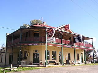
Coolac is a village in the Riverina region of New South Wales, Australia in Gundagai Council. At the 2016 census, Coolac had a population of 216.

Lands administrative divisions of Australia are the cadastral divisions of Australia for the purposes of identification of land to ensure security of land ownership. Most states term these divisions as counties, parishes, hundreds, and other terms. The eastern states of Queensland, New South Wales, Victoria and Tasmania were divided into counties and parishes in the 19th century, although the Tasmanian counties were renamed land districts in the 20th century. Parts of South Australia (south-east) and Western Australia (south-west) were similarly divided into counties, and there were also five counties in a small part of the Northern Territory. However South Australia has subdivisions of hundreds instead of parishes, along with the Northern Territory, which was part of South Australia when the hundreds were proclaimed. There were also formerly hundreds in Tasmania. There have been at least 600 counties, 544 hundreds and at least 15,692 parishes in Australia, but there are none of these units for most of the sparsely inhabited central and western parts of the country.

Argyle County was one of the original Nineteen Counties in New South Wales and is now one of the 141 Cadastral divisions of New South Wales. It includes the area around Goulburn. It is bounded by Lake George in the south-west, the Shoalhaven River in the east, and the Wollondilly River in the north-east.

The Parish of Marulan is a parish of Argyle County located with the Goulburn Mulwaree local government area, which includes the towns of Marulan and Marulan South. The parish is bounded by Barbers Creek to the east, a small part of the Shoalhaven River to the south-east, and Jerrara Creek to the south. The Hume Highway and the Southern Highlands railway line run through the parish. Jerrara Road and Marulan South Road are other main roads in the area.

The Parish of Tarago is a parish of Argyle County. It does not actually contain the town of Tarago, which is located further to the south-east in the Parish of Mulwaree. The Parish was built by the Department of Lands in New South Wales.
The Parish of Wologorong is a parish of Argyle County, New South Wales, Australia.

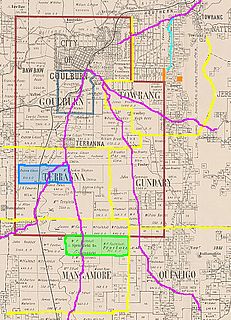
The Parish of Goulburn is a parish of Argyle County which includes most of the city of Goulburn, New South Wales.

The Parish of Towrang is a parish of Argyle County located to the south-east of Goulburn, and including some of its outer suburbs such as Goulburn North, and the area to the east of the Wollondilly River and Mulwaree Ponds. The Goulburn War Memorial is also located in this parish. The village of Towrang is located at the north-eastern edge of the parish, with Towrang creek part of the boundary in this area.
The Parish of Nattery is a parish of Argyle County located between Goulburn and Marulan in New South Wales. It is just east of the village of Towrang and includes the locality of Carrick. The Wollondilly River is the boundary in the north-west. Jerraba creek is part of the boundary in the south-east. The Southern Highlands railway line runs through the northern end of the parish, to the east of the Wollondilly river. The Hume Highway passes through the middle of the parish.

Currawang is a locality in the Queanbeyan–Palerang Regional Council, on the edges of Upper Lachlan Shire and Goulburn-Mulwaree Council, in New South Wales, Australia. It is located to the north of Lake George. It shares its name with the Currawang Parish of Argyle County, in which it is located. This was formerly known as the parish of Currowang. Both names derive from an Aboriginal word for the spearwood tree.

The Parish of Milbang is a parish of Argyle County, New South Wales, Australia, located at 34.4954°S 149.2604°E

The Parish of Baw Baw is a parish of Argyle County, New South Wales, Australia. It is located in to the west of Goulburn, in Goulburn Mulwaree Council at 34°42′54″S, 149°38′04″E.

Wollogorang is a locality in the Upper Lachlan Shire and Goulburn Mulwaree Council, New South Wales, Australia. A small part of the locality is in Queanbeyan–Palerang Regional Council. It is located about 35 km southwest of Goulburn and 61 km northeast of Canberra. It lies on both sides of the Federal Highway and on the southern side of the Hume Highway. They intersect nearby to the northeast in the locality of Yarra. At the 2016 census, it had a population of 67.

Colinton is a locality in the Snowy Monaro Region, New South Wales, Australia. At the 2016 census, it had a population of 127. There was once a village and railway station of the same name.

Pinaroo is a remote civil parish of Poole County in far north west New South Wales, located at 29°08′04″S 141°06′55″E.

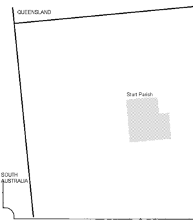
Sturt Parish is a remote civil parish of Poole County in far North West New South Wales, located at 29.433056°S 141.519722°E.
The Parish of Tindara is a remote civil parish of Poole County in far North West New South Wales,.


