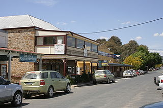
Braidwood is a town in the Southern Tablelands of New South Wales, Australia, in Queanbeyan–Palerang Regional Council. It is located on the Kings Highway linking Canberra with Batemans Bay. It is approximately 200 kilometres south west of Sydney, 60 kilometres inland from the coast, and fifty-five from Canberra. Braidwood is a service town for the surrounding district which is based on sheep and cattle grazing, and forestry operations.
The Mosman Council is a local government area on the Lower North Shore of Sydney, New South Wales, Australia.

Bannaby is a locality in the Southern Tablelands of New South Wales, Australia in Upper Lachlan Shire. It is located near the township of Taralga, on the Bannaby road. At the 2016 census, it had a population of 36.

Boro is a rural locality of New South Wales, Australia in the Queanbeyan-Palerang Region, near the village of Tarago, about 50 km south of Goulburn. The name is a variation of the Aboriginal bora ring. At the 2016 census, it had a population of 94.
Bungendore is a town in the Queanbeyan Region of New South Wales, Australia, in Queanbeyan-Palerang Regional Council. It is on the Kings Highway near Lake George, the Molonglo River Valley and the Australian Capital Territory border. It has become a major tourist centre in recent years, popular with visitors from Canberra and some of it has heritage protection. It has expanded rapidly in recent years as a dormitory town of Canberra.

Bulahdelah is a town and locality in the Hunter/Mid North Coast region of New South Wales, Australia in the Mid-Coast Council local government area. At the 2016 census, the locality had a population of 1,424. The main population centre, where 69% of the area's population lived in 2006, is the town of Bulahdelah.

Gunderman is a locality of the Central Coast region of New South Wales, Australia, located on the north bank of the Hawkesbury River between the towns of Wisemans Ferry and Spencer. It is located within the Central Coast Council local government area. It adjoins the Dharug National Park. At the 2006 census, Gunderman had a population of 137 people.

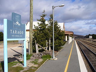
The Parish of Tarago is a parish of Argyle County. It does not actually contain the town of Tarago, which is located further to the south-east in the Parish of Mulwaree.
Avon is as a suburb of the City of Wollongong and Wingecarribee Shire, both in New South Wales, Australia. It is: "a locality within Metropolitan Catchment Area on the western side of Illawarra Range about 4km west of Wongawilli and about 5km north west of Avondale". At the 2016 census, it had no population.

Queanbeyan–Palerang Regional Council is a local government area located in the Southern Tablelands region of New South Wales, Australia. The council was formed on 12 May 2016 through a merger of the City of Queanbeyan and Palerang Council.

Mount Fairy is a locality in the Queanbeyan–Palerang Regional Council, New South Wales, Australia. It is located to the east of the Bungendore–Tarago road. At the 2016 census, it had a population of 205.

Marchmont is a locality in the Yass Valley Council, New South Wales, Australia. It lies on the Barton Highway about 10 km to the southeast of Yass. At the 2016 census, it had a population of 229.

Beaumont is a locality in the City of Shoalhaven in New South Wales, Australia. It lies on Cambewarra Range about 18 km north of Nowra on both sides of the Kangaroo Valley–Nowra road. It includes the Cambewarra Mountain lookout, which gives a good view of the lower Shoalhaven valley. At the 2016 census, it had a population of 125.

Cambewarra Village is a locality in the City of Shoalhaven in New South Wales, Australia. It lies on Main Road, which runs west from Cambewarra Road, which forms part of the Kangaroo Valley–Nowra road, about 9 km northwest of Nowra and south of Cambewarra Mountain. At the 2016 census, it had a population of 1,189. Cambewarra Village is largely surrounded by the locality of Cambewarra.

Manar is a locality in the Queanbeyan-Palerang Region, Southern Tablelands, New South Wales, Australia. It lies on both sides of the Kings Highway between Bungendore and Braidwood at the intersection with the Braidwood–Goulburn road. At the 2016 census, it had a population of 118.

Mayfield is a locality in the Queanbeyan–Palerang Regional Council, New South Wales, Australia. It is located about 85 km east of Canberra and 58 km south of Goulburn. At the 2016 census, it had a population of 22. It had an Anglican church, St Luke's from 1895 to 1965. A "half-time" school was located at Virginia station in Mayfield from 1894 to 1899.

Mayfield is a heritage-listed homestead complex at Mayfield Road, Lower Boro, Queanbeyan-Palerang Region, New South Wales, Australia. It was added to the New South Wales State Heritage Register on 18 November 1999.
Middle Falbrook is a locality in the Singleton Council region of New South Wales, Australia. It had a population of 92 as of the 2016 census.
Eucumbene is a locality in the Snowy Monaro Regional Council in New South Wales, Australia. In the 2016 census, Eucumbene had a population of 12 people.