Williamsdale, Australian Capital Territory

Last updated

Williamsdale
Australian Capital Territory
Williamsdale garage, Williamsdale, ACT.jpg
Abandoned garage in Williamsdale
Australia Capital Territory location map.svg
Red pog.svg
Williamsdale
Coordinates 35°34′11″S149°08′05″E / 35.56972°S 149.13472°E / -35.56972; 149.13472 Coordinates: 35°34′11″S149°08′05″E / 35.56972°S 149.13472°E / -35.56972; 149.13472
PopulationNot known (2021 census)
Location35 km (22 mi) S of Canberra
Territory electorate(s) Brindabella
Federal division(s) Bean
Localities around Williamsdale:
Paddys River (district) Tuggeranong (district) Royalla (NSW)
Tennent (district) Williamsdale Williamsdale (NSW)
Tennent (district) The Angle Williamsdale (NSW)

Williamsdale is the name sometimes given to the unbounded locality situated immediately on the north-west side of the Australian Capital Territory border abutting the locality of Williamsdale in the Southern Tablelands region of New South Wales, Australia. The Monaro Highway and the former Bombala railway pass through the area. A railway station saw service until 1975. The postcode is 2620. The Australian Capital Territory portion is located in the District of Tuggeranong.

Contents

Structure

The Australian Bureau of Statistics included the ACT part of Williamsdale in an area called "Tuggeranong (SA2)". This statistical area also includes the ACT part of Royalla and all the rural territory between the Murrumbidgee River and the NSW border. It had a population of 43 at the 2021 census. [1] The part in NSW had a population of 65 at that census. [2]

The part of Williamsdale [3] in NSW [4] is itself split up by two Local Government Areas, in the north to Queanbeyan–Palerang and in the south to Snowy Monaro.

Geology

To the east of Williamsdale is the Williamsdale Volcanics. These are made up from blue-green crystal tuff. The crystals are sized from 0.3 mm to 1 mm and are embedded in a fine matrix. Quartz crystals make up 25%, plagioclase 5%, alkali feldspar 10%, biotite 5–10% which is altered to chlorite, epidote and leucoxene.

Middle Silurian Colinton Volcanics foliated dacite and tuff is under Williamsdale. A roughly north south band of these acid volcanics extends to the north along the Monaro Highway and then follows the Cooma road to Cottondale. South the volcanics also follow the Monaro Highway in a more complex band through Colinton past Michelago and at least as far south as Bredbo.

To the west of Williamsdale is an outcrop of Upper Silurian Laidlaw Volcanics dark grey rhyodacitic and dacitic crystal tuff. This extends to the west as far as Angle Crossing. This band extends to the north north west as far as Mount Stromlo. The outcrop finishes a couple of kilometres south, but it is also found to the east, with outcrop from Fernleigh in the north, via Burra, and south to Michelago.

On the west side of the Murrumbidgee River around Angle Crossing can be found the Bransby Beds or Goosoon Beds. These beds contain tuff and dacite with some sediments. They form a narrow band extending to the south as far as Cooma following on the east side of the Murrumbidgee River. [5]

Airport proposal

In response to increasing operating costs for general aviation users of Canberra Airport, a proposal was made by the ACT Government in 2005 to develop a dedicated secondary airfield for the Territory. [6] The site recommended was to the west of the Monaro Highway at Williamsdale, and would include aircraft hangars, maintenance and fuel facilities, and a 1000m grass runway. A feasibility study was undertaken by Deloitte Access Economics in 2010. Based on the results of this study, the project anticipated marginal returns on the capital investment required, despite significant demand for such a facility. [7] As of 2012, the ACT government has declined to develop the facility, but has made the cost benefit analysis and feasibility study reports available should private enterprise wish to consider the project.

Solar farm

Willamsdale solar farm Willamsdale solar farm.jpg
Willamsdale solar farm

In September 2012, utilities provider ActewAGL was granted an exemption by the ACT Government from having to conduct a further Environmental impact assessment on a plan to construct a 45ha electricity generation facility consisting of 15 photovoltaic solar arrays with a total generating capacity of 20 megawatts and associated infrastructure adjacent to the Monaro Highway at Williamsdale. [8] The land to be occupied by the proposed solar farm was acquired by ActewAGL in 2009, [9] and was considered preferable to an alternative site in the West Belconnen district. [10]

The project was later reduced in scope to 11.8 megawatts. It was approved in January 2016 by the ACT Planning Minister, Mick Gentleman. [11] Subsequently, Elementus Energy which had owned the project sold it to a subsidiary of Melbourne-based Impact Investment Group, and the German company ib vogt GmbH was contracted for the construction. [12] The first solar panel was installed in October 2016. [13] Construction was completed in October 2017. It uses a single axis sun-tracking system. [14] [15]

Related Research Articles

<span class="mw-page-title-main">Australian Capital Territory</span> Territory of Australia

The Australian Capital Territory, known as the Federal Capital Territory (FCT) until 1938, is a landlocked federal territory of Australia containing the national capital Canberra and some surrounding townships. It is located in southeastern Australian mainland as an enclave completely within the state of New South Wales. Founded after Federation as the seat of government for the new nation, all important institutions of the Australian Government are headquartered in the territory.

Molonglo River River in Australia

The Molonglo River, a perennial river that is part of the Murrumbidgee catchment within the Murray–Darling basin, is located in the Monaro and Capital Country regions of New South Wales and the Australian Capital Territory, in Australia.

<span class="mw-page-title-main">Monaro Highway</span> Highway in Australia

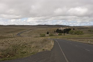
The Monaro Highway is a highway in Victoria, New South Wales, and the Australian Capital Territory, in Australia.

<span class="mw-page-title-main">Snowy Mountains Highway</span> State highway in New South Wales, Australia

Snowy Mountains Highway is a 333-kilometre-long (207 mi) state highway located in New South Wales, Australia. Its two sections connect the New South Wales South Coast to the Monaro region, and the Monaro to the South West Slopes via the Snowy Mountains. The higher altitude regions of this road are subject to snow over the winter months, and the road also provides access to many parts of the Snowy Mountains Scheme. The highway bears the B72 shield along its entire length.

Monaro (New South Wales) Region in New South Wales, Australia

Monaro, once frequently spelled "Manaro", or in early years of settlement "Maneroo" is a region in the south of New South Wales, Australia. A small area of Victoria near Snowy River National Park is geographically part of the Monaro. While the Australian Capital Territory is not considered part of the region, some towns in the Monaro have close links with Canberra.

Michelago Town in New South Wales, Australia

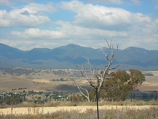
Michelago is a village in the Monaro region of New South Wales, Australia. The village is in the Snowy Monaro Regional Council local government area, 54 kilometres (34 mi) south of Canberra on the Monaro Highway. It was founded in the 1820s, on the main route from Sydney to the Snowy Mountains. At the 2016 census, Michelago had a population of 562.

Greenway, Australian Capital Territory Suburb of Canberra, Australian Capital Territory

Greenway is a suburb in the Canberra, Australia district of Tuggeranong. The postcode is 2900. The suburb is named after the architect, Francis Greenway (1777–1837). It was gazetted on 17 October 1986. The streets are named after architects. It includes the Tuggeranong Town Centre, Lake Tuggeranong and small residential areas on the northwestern and northeastern shores of the lake.

<span class="mw-page-title-main">Kambah, Australian Capital Territory</span> Suburb of Canberra, Australian Capital Territory

Kambah is the northernmost suburb in the district of Tuggeranong, Canberra. It is located just south of Mount Taylor in the Canberra Nature Park. It is located north of the suburbs of Greenway and Wanniassa. It is bounded by Sulwood Drive to the north and Athllon Drive to the south-east.

Uriarra Village is a community in the District of Coree, Australian Capital Territory established in 1928 at the foothills of the Australian Alps. A nearby area to the north of the border in New South Wales is also called Uriarra.

Geology of the Australian Capital Territory Overview of the geology of the Australian Capital Territory

The geology of the Australian Capital Territory includes rocks dating from the Ordovician around 480 million years ago, whilst most rocks are from the Silurian. During the Ordovician period the region—along with most of eastern Australia—was part of the ocean floor. The area contains the Pittman Formation consisting largely of Quartz-rich sandstone, siltstone and shale; the Adaminaby Beds and the Acton Shale.

Parish of Tuggeranong Cadastral in New South Wales, Australia

Tuggeranong Parish is a parish of Murray County, New South Wales, a cadastral unit for use on land titles. It is now about a third of the size it was in the nineteenth century, after most of the land in the parish was transferred to the Australian Capital Territory in 1911. It currently includes a small section of land in New South Wales between the ACT border and Jerrabomberra Creek, but once included most of what is now the Canberra town centre of Tuggeranong.

Bombala railway line

The Bombala railway line is a branch railway line in the south of New South Wales, Australia. The northern part of it forms part of the main line from Sydney to Canberra, but the southern part is closed. It branches off the Main South line at Joppa Junction, south of Goulburn. The line is used by NSW TrainLink Xplorer services running between Sydney Central and Canberra station.

Williamsdale is a locality situated immediately on the south-east side of the New South Wales border abutting the locality of Williamsdale in south-eastern Australian Capital Territory, Australia. The Monaro Highway and the former Bombala railway pass through the village. A railway station saw service from 1891 until 1975. The postcode is 2620.

Shannons Flat Town in New South Wales, Australia

Shannons Flat is a locality in the Monaro region of New South Wales, Australia. The town is in the Snowy Monaro Regional Council local government area, sandwiched between the southern border of the Namadgi National Park in the Australian Capital Territory and the Murrumbidgee River. Shannons Flat also adjoins the NSW localities of Yaouk, Bolaro, Murrumbucca, Bredbo and Billilingra. It is about 308 kilometres (191 mi) south west of the state capital, Sydney, and 70 kilometres (40 mi) from the Australian national capital of Canberra. It is just over 40 kilometres (25 mi) north west of the regional centre, Cooma.

Royalla Town in New South Wales, Australia

Royalla is a rural locality on the border of New South Wales and the Australian Capital Territory. The area takes its name from the nearby Mount Rob Roy, and was originally a railway settlement on the Bombala railway line known as Rob Roy and changed to the current name in 1905. Modern Royalla is a large rural locality east of the Monaro Highway. The border with the ACT follows the western boundary of the easement of the former railway line to the east of the highway. The town was served by a railway station until 1975. The NSW part of Royalla had a population of 984 at the 2016 census.

Tuggeranong Creek River in Australian Capital Territory, Australia

Tuggeranong Creek, a partly perennial stream of the Murrumbidgee catchment within the Murray–Darling basin, is located in the Tuggeranong district of Canberra, within the Australian Capital Territory, Australia.

Rock Flat Creek River in New South Wales, Australia

Rock Flat Creek is a watercourse that is part of the Murrumbidgee catchment within the Murray–Darling basin. It is located in the Monaro region of New South Wales, Australia.

Snowy Monaro Regional Council Local government area in New South Wales, Australia

The Snowy Monaro Regional Council is a local government area located in the Snowy Mountains and Monaro regions of New South Wales, Australia. The council was formed on 12 May 2016 through a merger of the Bombala, Cooma-Monaro and Snowy River shires.

Colinton, New South Wales Town in New South Wales, Australia

Colinton is a locality in the Snowy Monaro Region, New South Wales, Australia. At the 2016 census, it had a population of 127. There was once a village and railway station of the same name.

Bumbalong is a rural locality in the Snowy Monaro Region, New South Wales, Australia. Although it lies in the valley of the Murrumbidgee River, it is sometimes referred to by its residents as Bumbalong Valley. At the 2016 census, it had a population of 24.

References

  1. Australian Bureau of Statistics (28 June 2022). "Tuggeranong (SA2)". 2021 Census QuickStats. Retrieved 2 September 2022. OOjs UI icon edit-ltr-progressive.svg
  2. Australian Bureau of Statistics (28 June 2022). "Williamsdale". 2021 Census QuickStats. Retrieved 2 September 2022. OOjs UI icon edit-ltr-progressive.svg
  3. "Williamsdale". OpenStreetMap. Retrieved 16 August 2017.
  4. "Williamsdale". Geographical Names Register (GNR) of NSW. Geographical Names Board of New South Wales . Retrieved 2 September 2022. OOjs UI icon edit-ltr-progressive.svg
  5. Henderson, G. A. M.; Matveev, G. (1980). Geology of Canberra, Queanbeyan and Environs (Map). 1:50000.
  6. "Williamsdale Airfield". Economic Development Directorate (ACT). 21 March 2012. Retrieved 27 May 2012.
  7. "Williamsdale Airfield Cost Benefit Analysis" (PDF). Deloitte Access Economics. 2011. Retrieved 27 May 2012.
  8. "Willamsdale Solar Facility Application for s211 Exemption Consideration Report" (PDF). ACT Government. September 2012. Retrieved 28 January 2013.
  9. "ACTEW land an option for ACT Solar Farm". ACTEW Water. 16 April 2009. Retrieved 28 January 2013.
  10. Towell, N (22 January 2013). "Push for capital's second solar farm". The Canberra Times . Retrieved 28 January 2013.
  11. McIlroy, Tom (29 January 2016). "Solar farm approved for Williamsdale". The Canberra Times. Retrieved 26 October 2016.
  12. Raggatt, Matthew (12 June 2016). "Tree felling continues after Elementus sells Williamsdale solar farm". The Canberra Times. Retrieved 26 October 2016.
  13. Connery, Georgina (25 October 2016). "One down, 34,999 photovoltaic panels to go at Williamsdale Solar Farm". The Canberra Times. Retrieved 26 October 2016.
  14. "Government unveils 36,000 new solar panels at Williamsdale". The Canberra Times. 5 October 2017. Archived from the original on 29 November 2017. Retrieved 1 December 2017.
  15. "The Impact Investment Group's Williamsdale Solar Farm". Diamond Energy. Archived from the original on 5 October 2017. Retrieved 3 December 2017.