Bibbenluke, New South Wales

Last updated

Bibbenluke
New South Wales
Bibbenluke Public Hall 003.JPG
Bibbenluke Public Hall, 2020
Australia New South Wales location map blank.svg
Red pog.svg
Bibbenluke
Coordinates 36°48′47″S149°17′17″E / 36.81306°S 149.28806°E / -36.81306; 149.28806 Coordinates: 36°48′47″S149°17′17″E / 36.81306°S 149.28806°E / -36.81306; 149.28806
Population87 (2016 census) [1]
Established1833
Postcode(s) 2632
Elevation728 m (2,388 ft)
Location
LGA(s) Snowy Monaro Regional Council
State electorate(s) Monaro
Federal division(s) Eden-Monaro
Mean max tempMean min tempAnnual rainfall
17.8 °C
64 °F
5.1 °C
41 °F
496.9 mm
19.6 in

Bibbenluke is a village in the Snowy Monaro Regional Council in southern New South Wales, Australia. The village is located at a crossing point of the Monaro Highway and Bombala River. The name is derived from a local Aboriginal word either meaning "Big Lookout" or "Place of Birds". [2]

Contents

History

In 1833, notable pastoralist Joshua John Moore established a sheep grazing property named "Bibbenluke", and from this property a number of other stations in the area were also managed. The significance of Bibbenluke grew throughout the 19th Century, helped somewhat by an association with another pioneer, Scottish-born Benjamin Boyd. Boyd established the port of Boydtown near the town of Eden east of the Monaro in 1843 to support pastoral activities on his properties in the region. A school was established to serve the growing community around the station in 1871, and by 1884 significant commerce and industry had developed, with 3 carpenters, a stonemason, a blacksmith, a hotel and at least two stores operating in the town. An Anglican church operated out of a community hall on the sheep station around this time and the building was eventually relocated to the townsite in 1937. [3]

On 11 January 1915 the Men from Snowy River recruitment banner march from Delegate and Goulburn visited the town and enlisted 6 men from the local community to serve with the 1st AIF during World War I. [4] A similar march along the same route passed through the town in April 1940 to recruit volunteers during World War II.

In 1977, Bibbenluke Shire was amalgamated into the former Bombala Shire. [3] December 1997 saw the opening of an upgraded bridge across the Bombala River, replacing the last remaining timber bridge on the Monaro Highway. [5] Bombala was further amalgamated in 2016 to become part of the Snowy Monaro Regional Council.

Present day

Modern Bibbenluke is a small community that has close links with and relies on the larger town of Bombala for many public services. The school remains, although enrollments as of 2013 are now as low as 11 pupils. The community hall is the focal point of the village. Other historic buildings in town include the Anglican church and the original Bibbenluke Hotel, although this has been converted to a private residence. There is also a cemetery located in the village. The local economy is based mostly around farming and tourism, with a number of small businesses operating, including the historic Ben Boyd Guesthouse and Bibbenluke Australian Stock Horse Stud. [6]

Notable residents

Related Research Articles

Monaro Highway Highway in Australia

The Monaro Highway is a highway in Victoria, New South Wales, and the Australian Capital Territory, in Australia.

Cooma Town in New South Wales, Australia

Cooma is a town in the south of New South Wales, Australia. It is located 114 kilometres (71 mi) south of the national capital, Canberra, via the Monaro Highway. It is also on the Snowy Mountains Highway, connecting Bega with the Riverina.

Bombala, New South Wales Town in New South Wales, Australia

Bombala is a town in the Monaro region of south-eastern New South Wales, Australia, in Snowy Monaro Regional Council. It is approximately 485 kilometres (301 mi) south of the state capital, Sydney, and 80 kilometres (50 mi) south of the town of Cooma. The name derives from an Aboriginal word meaning "Meeting of the waters". The town lies on the banks of the Bombala River. At the 2016 census, Bombala had a population of 1,387.

Monaro (New South Wales) Region in New South Wales, Australia

Monaro, once frequently spelled "Manaro", or in early years of settlement "Maneroo" is a region in the south of New South Wales, Australia. A small area of Victoria near Snowy River National Park is geographically part of the Monaro. While the Australian Capital Territory is not considered part of the region, some towns in the Monaro have close links with Canberra.

Bredbo Town in New South Wales, Australia

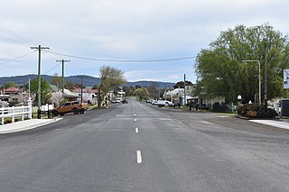
Bredbo is a village on the Monaro plains of New South Wales, Australia. The village is on the Monaro Highway 34 kilometres (21 mi) north of Cooma. The village is in the Snowy Monaro Regional Council and had a population of 352 at the 2016 census.

Cooma-Monaro Shire Local government area in New South Wales, Australia

Cooma-Monaro Shire was a local government area located in the Monaro region of southern New South Wales, Australia. The area was named after the former Cooma Municipality and the former Monaro Shire, that were amalgamated to create it. The Municipality of Cooma was established in 1879, and the Monaro Shire was one of several shires established in 1906. The Monaro Shire and Cooma Municipal Council amalgamated in 1981. On 11 February 2004, Cooma-Monaro Shire absorbed a small part of the former Yarrowlumla Shire, near Michelago.

Snowy River Shire Local government area in New South Wales, Australia

The Snowy River Shire was a local government area in the Australian Alps region of New South Wales, Australia from 1939 until May 2016. It was named after the Snowy River that runs through it. Prior to 1936, it had been named as Dalgety Shire since establishment in 1906.

Group 16 is a rugby league competition on the south coast of New South Wales, run under the auspices of the Country Rugby League. Group 16 covers the area from Batemans Bay down to Eden.

Delegate, New South Wales Town in New South Wales, Australia

Delegate is a small town in New South Wales, Australia in Snowy Monaro Regional Council, 523 kilometres (325 mi) south of the state capital, Sydney.

Bombala Shire Local government area in New South Wales, Australia

The Bombala Shire was a local government area in the Monaro region of south-eastern New South Wales, Australia. The Shire includes the town of Bombala, the villages of Delegate, Cathcart, Bibbenluke and the localities of Ando, Bungarby, Craigie, Mila, Rockton and Creewah. Bombala Shire was formed on 1 October 1977 by the amalgamation of the Municipality of Bombala and Bibbenluke Shire.

Bombala railway line

The Bombala railway line is a branch railway line in the south of New South Wales, Australia. The northern part of it forms part of the main line from Sydney to Canberra, but the southern part is closed. It branches off the Main South line at Joppa Junction, south of Goulburn. The line is used by NSW TrainLink Xplorer services running between Sydney Central and Canberra station.

The Bombala River, a perennial river of the Snowy River catchment, is located in the Monaro region of New South Wales, Australia.

The Coolumbooka River, a perennial river of the Snowy River catchment, is located in the Monaro region of New South Wales, Australia.

The Undowah River, a perennial river of the Snowy River catchment, is located in the Monaro region of New South Wales, Australia.

Cathcart, New South Wales Town in New South Wales, Australia

Cathcart is a village in the Snowy Monaro Regional Council in southern New South Wales, Australia. The village is on the Mount Darragh Road, linking the town of Bombala with the port of Eden on the Far South Coast.

Ando, New South Wales Town in New South Wales, Australia

Ando is a rural hamlet with a very small population in the Snowy Monaro Regional Council in southern New South Wales, Australia. The village is at the junction of the Monaro Highway and Snowy River Way, about 20 km (12 mi) north of Bombala. The surrounding area is predominantly agricultural land holdings.

Snowy Monaro Regional Council Local government area in New South Wales, Australia

The Snowy Monaro Regional Council is a local government area located in the Snowy Mountains and Monaro regions of New South Wales, Australia. The council was formed on 12 May 2016 through a merger of the Bombala, Cooma-Monaro and Snowy River shires.

Colinton, New South Wales Town in New South Wales, Australia

Colinton is a locality in the Snowy Monaro Region, New South Wales, Australia. At the 2016 census, it had a population of 127. There was once a village and railway station of the same name.

Bibbenluke Shire was a local government area in the Monaro region of New South Wales, Australia.

Numeralla Town in New South Wales, Australia

Numeralla is a village in Snowy Monaro Region of New South Wales, Australia. In 2016, the population of the village and its surrounding area was 258. The village was known as Umaralla until 1972.

References

  1. Australian Bureau of Statistics (27 June 2017). "Bibbenluke (State Suburb)". 2016 Census QuickStats. Retrieved 6 July 2017. OOjs UI icon edit-ltr-progressive.svg
  2. "Bibbenluke". Geographical Names Register (GNR) of NSW. Geographical Names Board of New South Wales . Retrieved 9 August 2012. OOjs UI icon edit-ltr-progressive.svg
  3. 1 2 "Platypus Country: Bombala Council: Community Plan" (PDF). Bombala.nsw.gov.au. Archived from the original (PDF) on 23 June 2015. Retrieved 24 October 2012.
  4. "REL/15959 - 'Men from Snowy River' recruiting march banner | Australian War Memorial". Cas.awm.gov.au. Archived from the original on 13 March 2011. Retrieved 9 August 2012.
  5. "National Route 23". Ozroads. Retrieved 9 August 2012.
  6. "Bombala.Bibbenluke,Cathcart,Delegate: Bibbenluke". Platypuscountry.org.au. Archived from the original on 20 August 2013. Retrieved 9 August 2012.

Commons-logo.svg Media related to Bibbenluke at Wikimedia Commons