
Cooma is a town in the south of New South Wales, Australia. It is located 114 kilometres (71 mi) south of the national capital, Canberra, via the Monaro Highway. It is also on the Snowy Mountains Highway, connecting Bega with the Riverina.

Bombala is a town in the Monaro region of south-eastern New South Wales, Australia, in Snowy Monaro Regional Council. It is approximately 485 kilometres (301 mi) south of the state capital, Sydney, and 80 kilometres (50 mi) south of the town of Cooma. The name derives from an Aboriginal word meaning "Meeting of the waters". The town lies on the banks of the Bombala River. At the 2016 census, Bombala had a population of 1,387.

Berridale is a small town in New South Wales of 1,197 people at the 2016 census and was the administrative centre of the Snowy River Shire until that shire merged with two others to form the Snowy Monaro Regional Council in 2016, one of Australia's major inland tourism destinations. Berridale lies at 860 metres above sea level between the towns of Cooma and Jindabyne and 435 kilometres south of Sydney.
Dalgety is a small town in New South Wales, Australia, on the banks of the Snowy River between Melbourne and Sydney.

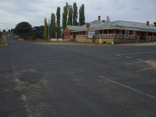
Bredbo is a village on the Monaro plains of New South Wales, Australia. The village is on the Monaro Highway 34 kilometres (21 mi) north of Cooma. The village is in the Snowy Monaro Regional Council and had a population of 352 at the 2016 census.

Nimmitabel is a small town in the Monaro region in southeast New South Wales, Australia, in the Snowy Monaro Regional Council local government area. At the 2016 census, Nimmitabel had a population of 320.

Henty is a town in southwestern New South Wales close to the boundaries of the South West Slopes and the Riverina districts, almost midway between the regional cities of Albury and Wagga Wagga. At the 2006 census, Henty had a population of 863 people.

Rosewood is a village community and locality in the south east part of the Riverina, New South Wales, Australia. It is situated about 16 kilometres (9.9 mi) south east from Carabost and 19 kilometres (12 mi) north west from Tumbarumba. At the 2016 census, Rosewood had a population of 214. The village is administered by two local governments; the northern part of the locality by the Greater Hume Shire and the southern part of the locality by the Snowy Valleys Council. The village of Rosewood is within the Snowy Valleys Council area.

Jerangle is a locality in New South Wales, Australia. The locality is in the Snowy Monaro Regional Council local government area, 366 kilometres (227 mi) south of the state capital, Sydney and 112 kilometres (70 mi) south east of the national capital, Canberra. At the 2016 census, Jerangle had a population of 96.

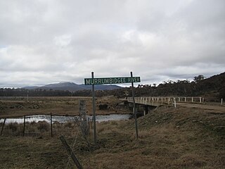
Shannons Flat is a locality in the Monaro region of New South Wales, Australia. The town is in the Snowy Monaro Regional Council local government area, sandwiched between the southern border of the Namadgi National Park in the Australian Capital Territory and the Murrumbidgee River. Shannons Flat also adjoins the NSW suburbs of Yaouk, Bolaro, Murrumbucca, Bredbo and Billilingra. It is about 308 kilometres (191 mi) south west of the state capital, Sydney, and 70 kilometres (40 mi) from the Australian national capital of Canberra. It is just over 40 kilometres (25 mi) north west of the regional centre, Cooma.

The Snowy Monaro Regional Council is a local government area located in the Snowy Mountains and Monaro regions of New South Wales, Australia. The council was formed on 12 May 2016 through a merger of the Bombala, Cooma-Monaro and Snowy River shires.

Colinton is a locality in the Snowy Monaro Region, New South Wales, Australia. It lies on the eastern side of the Murrumbidgee River and on both sides of the Monaro Highway about 73 km south of Canberra and about 44 km north of Cooma. At the 2016 census, it had a population of 127.

Chakola is a locality in the Snowy Monaro Region, New South Wales, Australia. It lies on both sides of the Murrumbidgee River and both sides of the Numeralla River. It also lies on both sides of the Monaro Highway about 100 km south of Canberra and about 25 km north of Cooma. At the 2016 census, it had a population of 47.

Bunyan is a locality in the Snowy Monaro Region, New South Wales, Australia. It lies on the eastern side of the Murrumbidgee River and on both sides of the Monaro Highway about 110 km south of Canberra and about 10 km north of Cooma. At the 2016 census, it had a population of 152.
Yaouk is a locality in the Snowy Monaro Region, New South Wales, Australia. It lies in open grassland valleys surrounded by mountains on both sides of the Murrumbidgee River, downstream from and east of the Tantangara Dam, north of Adaminaby, east of the Kosciuszko National Park and south of the Namadgi National Park in the Australian Capital Territory, but separated from it by the mountainous Scabby Range. It is about 110 km south of Canberra and about 75 km northwest of Cooma. At the 2016 census, it had a population of 25.

Dry Plain is a locality in the Snowy Monaro Region, New South Wales, Australia. It is located in grasslands mainly to the east of the Snowy Mountains Highway, about 25 km southeast of Adaminaby and 40 km northwest of Cooma, straddling an altitude of approximately 1,260 m above mean sea level. It is about 160 km south of Canberra. At the 2016 census, it had a population of 42.
Wambrook is a locality in the Snowy Monaro Region, New South Wales, Australia. It is located in grasslands mainly to the northeast of the Snowy Mountains Highway, about 30 km southeast of Adaminaby and 25 km northwest of Cooma, situated at the foot of the ranges at an altitude of 865 m above mean sea level. It is about 140 km south of Canberra. At the 2016 census, it had a population of 44.

Pine Valley is a locality in the Snowy Monaro Region, New South Wales, Australia. It is located to the south of the Snowy Mountains Highway, to the immediate southwest of Cooma. At the 2016 census, it had a population of 32.

Tinderry is a locality in the Snowy Monaro Region, New South Wales, Australia. It lies to the east of Michelago and South West of Captains Flat. At the 2016 census, it had a population of 66. The western part of the locality lies on the Tinderry Range, which includes Tinderry Peak and Tinderry Twin Peak. A large part of the mountainous terrain forms Tinderry Nature Reserve. Further east the terrain is more open and includes grazing country and the small settlement of Little Tinderry. A public school was located at Little Tinderry from 1899 to 1913, generally described as "half-time", but "provisional" in 1900 and early 1901.

Rhine Falls is a locality within the Snowy Monaro Regional Council, straddling between Wambrook and Dry Plain; at an altitude of 1,320 m above mean sea level, thereby ranking as one of the highest-elevated localities in Australia. Likewise, snow falls heavily and frequently from May through to September, and can fall at any time of the year. At the 2016 census, it had a population of 42, the same as neighbouring Dry Plain.

