Copeton Dam

Last updated

Copeton Dam
Copeton Dam Spillway.jpg
Copeton Dam spillway, from the northern side looking west.
Australia New South Wales relief location map.png
Red pog.svg
Location of the Copeton Dam
in New South Wales
Location New England, New South Wales, Australia
Coordinates 29°54′23″S150°55′38″E / 29.90639°S 150.92722°E / -29.90639; 150.92722 Coordinates: 29°54′23″S150°55′38″E / 29.90639°S 150.92722°E / -29.90639; 150.92722
Purpose hydro-electric power generation, irrigation, and water supply
StatusOperational
Construction began1968
Opening date1973
Owner(s) WaterNSW
Dam and spillways
Type of dam Embankment dam
Impounds Gwydir River
Height113 m (371 ft)
Length1,484 m (4,869 ft)
Width (crest)10.7 m (35 ft)
Dam volume8,547 m3 (301,800 cu ft)
Spillway type Gate-controlled concrete chute spillway
Spillway capacity1,280,000 ML (45,000×10^6 cu ft) per day
Reservoir
CreatesLake Copeton
Total capacity1,364,000 ML (48,200×10^6 cu ft)
Catchment area 5,360 km2 (2,070 sq mi)
Surface area4,600 ha (11,000 acres)
Maximum width427 m (1,401 ft)
Maximum water depth104 m (341 ft)
Power Station
Operator(s) AGL Energy
Commission dateDecember 1996 (1996-12)
Type Conventional
Turbines 1
Installed capacity 21 MW (28,000 hp)
Annual generation 54.3 GWh (195 TJ)
Website
Copeton Dam at www.statewater.com.au

Copeton Dam is a major clay core and rock fill embankment dam with nine radial gates and a gated concrete chute spillway across the Gwydir River upstream of Bingara in the New England region of New South Wales, Australia. The dam's purpose includes environmental flows, hydro-electric power generation, irrigation, and water supply. The impounded reservoir is called Lake Copeton.

Contents

Location and features

Commenced in March 1968, commissioned in 1973, and completed in 1976, the Copeton Dam is a major dam on the Gwydir River, a tributary of the Barwon River, and is located approximately 35 kilometres (22 mi) southwest of Inverell, between Bingara and Bundarra. [1] The dam was built by the New South Wales Water Conservation & Irrigation Commission and the Department of Water Resources to supply water for irrigation. Water from the dam is now released directly into the Gwydir River which is used by irrigators downstream of the dam including for pecan nut farming, and for producing cotton, wheat, lucerne, vegetables, fruit trees, oil seeds and fodder as well as pastures for sheep and cattle. The dam wall comprises 8,547 cubic metres (301,800 cu ft) of rock fill and is 113 metres (371 ft) high and is 1,484 metres (4,869 ft) long. The maximum water depth is 104 metres (341 ft) and at 100% capacity the dam wall holds back 1,364,000 megalitres (48,200×10^6 cu ft) of water at 572 metres (1,877 ft) AHD. The surface area of Lake Copeton is 4,620 hectares (11,400 acres) and the catchment area is 2,360 square kilometres (910 sq mi). The gate-controlled concrete chute spillway is capable of discharging 1,280,000 megalitres (45,000×10^6 cu ft) of water per day. [2] [3] [4]

Together with a series of diversionary weirs and regulatory works downstream from the dam, Copeton is able to provide a reliable flow of water to 30,000 hectares (74,000 acres) of land. This amount is much less than the 50,000 hectares (120,000 acres) originally planned because of higher rates of absorption and evaporation along some of the irrigation channels. [5] Despite these overestimates irrigated agriculture in the Gwydir Valley saw the area become Australia's major cotton-producing region.

View of the storage in Copeton Dam in October 2006 Copeton Dam Storage.jpg
View of the storage in Copeton Dam in October 2006

Upgrade of facilities

Aerial photograph of Copeton Dam under construction in 1972 Copeton Dam - 1972.jpg
Aerial photograph of Copeton Dam under construction in 1972

In 2007, it was decided the dam would need an upgrade for safety reasons. The A$70 million upgrade is expected to be completed during 2013 and Stage One involves the construction of a four-bay, 250-metre (820 ft)-wide, fuse plug spillway at Diamond Bay to enable the dam to safely pass extreme floods. [6] Once the fuse plug is installed the dam wall will be raised and the spillway gate modified. [7]

Spillway

Unexpected erosion of hard, sound, unweathered granite in the unlined spillway discharge channel was caused by rock failure under high in-situ compressive stress. This type of erosion due to high in-situ stress has not been reported elsewhere in the world. [8] [9]

Remedial works involved building a training wall to separate the original single spillway into a service spillway and a secondary (emergency) spillway. A concrete slab, anchored to the underlying rock was constructed in the floor of the main scour channel to provide some additional protection on those rare occasions when the secondary spillway will discharge water over this area. The smaller, more frequent flood events will be discharged through the service spillway onto more scour resistant rock which has performed satisfactorily to date. The secondary spillway will operate very infrequently and will only discharge when the capacity of the service spillway is exceeded. [8] [9]

Geological investigations for the design of these remedial works included surface stress measurements in the unlined spillway discharge channel as well as geological mapping and diamond core drilling. [8] [9]

Power generation

A hydro-electric power station generates up to 21 megawatts (28,000 hp) of electricity from the flow of the water leaving Copeton Dam with an average annual output of 54.3 gigawatt-hours (195 TJ). [4] The station was completed in December 1996. The facility is managed by AGL Energy. [10]

Recreation

Copeton Dam offers sailing, windsurfing, boating, water skiing, fishing and swimming while bushwalkers can enjoy unusual geological formations, lake and mountain views and a wide variety of plant life. [2]

See also

Related Research Articles

<span class="mw-page-title-main">Glenbawn Dam</span> Dam in Hunter region, New South Wales

Glenbawn Dam is a major ungated earth and rock fill with clay core embankment dam with concrete chute spillway plus fuse plugs across the Hunter River upstream of Aberdeen in the Hunter region of New South Wales, Australia. The dam's purpose includes flood mitigation, hydro-electric power, irrigation, water supply and conservation. The impounded reservoir is called Lake Glenbawn.

<span class="mw-page-title-main">Keepit Dam</span> Dam in North West Slopes, New South Wales

Keepit Dam is a major gated mass concrete gravity dam with an earth fill abutment and a central gated concrete overflow crest and six radial gate spillways across the Namoi River upstream of its junction with the Peel River in the North West Slopes region of New South Wales, Australia. The dam's purpose includes flood mitigation, hydro-power, irrigation, water supply and conservation. The impounded reservoir is called Lake Keepit.

<span class="mw-page-title-main">Burrendong Dam</span> Dam in Wellington, New South Wales

Burrendong Dam is a rock-fill embankment major gated dam with a clay core across the Macquarie River upstream of Wellington in the central west region of New South Wales, Australia. The dam's purpose includes flood mitigation, irrigation, water supply and hydro-electric power generation. The dam impounds Lake Burrendong and is filled by the waters from the Macquarie, and Cudgegong rivers as well as Meroo Creek.

<span class="mw-page-title-main">Glennies Creek Dam</span> Dam in New South Wales

Glennies Creek Dam is a minor ungated concrete faced curved earth and rockfill embankment dam with an uncontrolled rock cut spillway across the Glennies Creek, upstream of Singleton, in the Hunter region of New South Wales, Australia. The dam's purpose includes flood mitigation, irrigation, water supply and conservation. The impounded reservoir is called Lake Saint Clair.

Lostock Dam is a minor rockfill and clay core embankment dam with a concrete lined, flip bucket spillway across the Paterson River upstream of the village of East Gresford in the Hunter region of New South Wales, Australia. The dam's purpose includes flood mitigation, irrigation, water supply and conservation. Mini hydro-power facilities were retrofitted in 2010. The impounded reservoir is also called Lostock Dam.

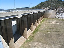
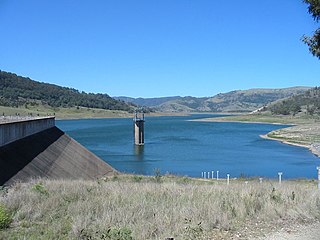
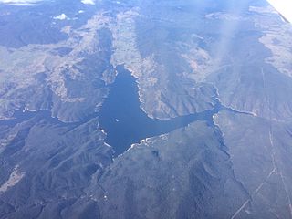
Windamere Dam is a minor ungated rock fill with clay core embankment dam with an uncontrolled unlined rock cutting spillway across the Cudgegong River at Cudgegong, upstream of Mudgee in the Central Tablelands of New South Wales, Australia. The dam's purpose includes hydro-power, irrigation, water supply, and conservation. The impounded reservoir is called Lake Windamere.

<span class="mw-page-title-main">Burrinjuck Dam</span> Dam in South West Slopes, New South Wales

Burrinjuck Dam is a heritage-listed major gated concrete-walled gravity hydro-electric dam at Burrinjuck, Yass Valley Shire, New South Wales, Australia. It has three spillways across the Murrumbidgee River located in the South West Slopes region of New South Wales, Australia. The dam's purpose includes flood mitigation, hydro-power, irrigation, water supply and conservation. The impounded reservoir is called Lake Burrinjuck. It was designed by Lawrence Augustus Burton Wade and built from 1907 to 1927 by Lane & Peters, Sydney. It is also known as Barren Jack Dam and Barrenjack. The property was owned by Department of Planning and Infrastructure. It was added to the New South Wales State Heritage Register on 2 April 1999.

<span class="mw-page-title-main">Blowering Dam</span> Dam in Snowy Mountains, New South Wales

The Blowering Dam is a major ungated rock fill with clay core embankment dam with concrete chute spillway impounding a reservoir under the same name. It is located on the Tumut River upstream of Tumut in the Snowy Mountains region of New South Wales, Australia. Purposes for the dam include flood mitigation, hydro-power, irrigation, water supply and conservation. The dam is part of the Snowy Mountains Scheme, a vast hydroelectricity and irrigation complex constructed in south-east Australia between 1949 and 1974 and now run by Snowy Hydro.

<span class="mw-page-title-main">Googong Dam</span> Dam in Queanbeyan, New South Wales

Googong Dam is a minor ungated earth and rock fill with clay core embankment dam with concrete chute spillway plus a nearby 13 metres (43 ft) high earthfill saddle embankment across the Queanbeyan River upstream of Queanbeyan in the Capital Country region of New South Wales, Australia. The dam's purpose includes water supply for Canberra and Queanbeyan. The impounded reservoir is called Googong Reservoir.

Cochrane Dam is a minor earthfill embankment dam with concrete spillway across Georges Creek, located in the South Coast region of New South Wales, Australia. The main purpose of the dam is to supply water for hydro-power at the downstream Brown Mountain Power Station and for irrigation purposes. The impounded reservoir is called Cochrane Lake.

<span class="mw-page-title-main">Split Rock Dam</span> Dam in North West Slopes, New South Wales

Split Rock Dam is a minor ungated concrete faced rock fill embankment dam with concrete chute spillway across the Manilla River upstream of Manilla in the north-western slopes region of New South Wales, Australia. The dam's purpose includes flood mitigation, irrigation, water supply and conservation. The impounded reservoir is called Split Rock Reservoir.

Pindari Dam is a minor concrete faced rockfill embankment dam with an ungated uncontrolled rock cut with concrete sill spillway across the Severn River located upstream of the town of Ashford, in the North West Slopes region of New South Wales, Australia. The dam's purpose includes flood mitigation, hydro-power, irrigation, water supply and conservation. The impounded reservoir is called Lake Pindari.

<span class="mw-page-title-main">Chaffey Dam</span> Dam in New South Wales, Australia

Chaffey Dam is a minor ungated rock fill with clay core embankment dam with an uncontrolled morning glory spillway across the Peel River, located upstream of the city of Tamworth, in the New England region of New South Wales, Australia. The dam's purpose includes flood mitigation, irrigation, water supply, and water conservation.

The Borumba Dam is a rock-fill embankment dam with an un-gated spillway located across the Yabba Creek in the Wide Bay–Burnett region of Queensland, Australia. The main purposes of the dam are for irrigation and potable water supply. The resultant impounded reservoir is called Lake Borumba.

<span class="mw-page-title-main">Toonumbar Dam</span> Dam in Northern Rivers, New South Wales

Toonumbar Dam is a minor ungated rock fill with clay core embankment dam with a concrete chute spillway across the Iron Pot Creek north-west of Casino in the Northern Rivers region of New South Wales, Australia. The dam's purpose includes hydro-power, irrigation, water supply, and conservation. The impounded reservoir is called Lake Toonumbar.

<span class="mw-page-title-main">Ben Chifley Dam</span> Dam in Central West, New South Wales

Ben Chifley Dam, or Chifley Dam, is a rock and earth-fill embankment dam across the Campbells River in the central west region of New South Wales, Australia. The main purpose of the dam is to supply potable water to the city of Bathurst.

Happy Jacks Dam is a major ungated concrete gravity dam across the Tumut River in the Snowy Mountains region of New South Wales, Australia. The dam's main purpose is for the generation of hydro-power and is one of the sixteen major dams that comprise the Snowy Mountains Scheme, a vast hydroelectricity and irrigation complex constructed in south-east Australia between 1949 and 1974 and now run by Snowy Hydro.

Island Bend Dam is a major ungated concrete gravity dam with a controlled spillway across the Snowy River in the Snowy Mountains region of New South Wales, Australia. The dam's main purpose is for the generation of hydro-power and is one of the sixteen major dams that comprise the Snowy Mountains Scheme, a vast hydroelectricity and irrigation complex constructed in south-east Australia between 1949 and 1974 and now run by Snowy Hydro.

Murray Two Dam or Murray 2 Dam is a major ungated concrete arch dam with a controlled spillway across Khancoban Bank, a diverted flow of the Snowy and Geehi rivers in the Snowy Mountains region of New South Wales, Australia. The impounded reservoir is called the Murray Two Pondage or Murray 2 Pondage.

Brogo Dam is a minor ungated rockfill embankment dam with an uncontrolled unlined rock cut spillway across the Brogo River upstream of Brogo in the South Coast region of New South Wales, Australia. The dam's purpose includes environmental flows, hydro-electric power generation, irrigation, and water supply. The impounded reservoir is also called Brogo Dam.

References

  1. "Copeton Dam". Geographical Names Register (GNR) of NSW. Geographical Names Board of New South Wales . Retrieved 14 April 2013. OOjs UI icon edit-ltr-progressive.svg
  2. 1 2 "Copeton Dam" (PDF). State Water Corporation. 2009. Archived from the original (PDF brochure) on 20 March 2012. Retrieved 15 April 2013.
  3. "Copeton Dam". Water delivery: Dams. State Water Corporation. Archived from the original on 11 April 2013. Retrieved 15 April 2013.
  4. 1 2 "Register of Large Dams in Australia" (Excel (requires download)). Dams information. The Australian National Committee on Large Dams Incorporated. 2010. Retrieved 22 April 2013.
  5. Pigram, John J. (2007). Australia's Water Resources: From use to management. Collingwood, Victoria: CSIRO Publishing. pp. 136–138. ISBN   978-0-643-09442-0.
  6. Amy Slessor (26 October 2007). "Copeton Dam upgrade unveiled". Inverell Times. Archived from the original on 22 March 2012. Retrieved 3 April 2011.
  7. "Copeton upgrade". Projects: Dam safety upgrades. State Water Corporation. Archived from the original on 18 April 2013. Retrieved 15 April 2013.
  8. 1 2 3 Woodward, Richard (2005). "Copeton Dam". Richard Woodward's Dam Projects. Retrieved 15 April 2013.
  9. 1 2 3 Woodward, Richard (2005). "Copeton Dam Spillway". Richard Woodward's Dam Projects. Retrieved 15 April 2013.
  10. "Copetoun (sic.) Power Station, New South Wales". Power generation portfolio: Hydro-electric. AGL Energy Limited. Archived from the original on 9 April 2013. Retrieved 15 April 2013.